
Huot, Minnesota
Encyclopedia
Unincorporated area
In law, an unincorporated area is a region of land that is not a part of any municipality.To "incorporate" in this context means to form a municipal corporation, a city, town, or village with its own government. An unincorporated community is usually not subject to or taxed by a municipal government...
in Louisville Township
Louisville Township, Red Lake County, Minnesota
Louisville Township is a township in Red Lake County, Minnesota, United States. The population was 192 at the 2000 census.-Geography:According to the United States Census Bureau, the township has a total area of 36.1 square miles , of which, 36.0 square miles of it is land and...
, Red Lake County, Minnesota
Minnesota
Minnesota is a U.S. state located in the Midwestern United States. The twelfth largest state of the U.S., it is the twenty-first most populous, with 5.3 million residents. Minnesota was carved out of the eastern half of the Minnesota Territory and admitted to the Union as the thirty-second state...
, United States
United States
The United States of America is a federal constitutional republic comprising fifty states and a federal district...
. The name of the village evokes the French-Canadian and Métis
Métis people (Canada)
The Métis are one of the Aboriginal peoples in Canada who trace their descent to mixed First Nations parentage. The term was historically a catch-all describing the offspring of any such union, but within generations the culture syncretised into what is today a distinct aboriginal group, with...
history of the Red River Trails
Red River Trails
The Red River Trails were a network of ox cart routes connecting the Red River Colony and Fort Garry in British North America with the head of navigation on the Mississippi River in the United States...
and the Pembina settlements of Assiniboia
Assiniboia
Assiniboia refers to a number of different locations and administrative jurisdictions in Canada. The name is taken from the Assiniboine First Nation.- District of Assiniboia:...
.
History
The location of Huot was originally dubbed the Old Crossing. In the 1840s and 1850s, this was a ford or crossingCrossing (river)
A river crossing is a means to get from one river bank to the other and may refer to:* A ford * A bridge* A tunnel* Any type of Ferry** A cable ferry** A reaction ferry** A water taxi-See also::Category:Crossings by river...
of the Red Lake River
Red Lake River
The Red Lake River is a river located in northwestern Minnesota. The river begins on the western side of the Lower Red Lake and flows westward. After passing through Thief River Falls, Red Lake Falls, and Crookston, the river merges with the Red River of the North in East Grand Forks. The total...
used by Red River ox cart
Red River ox cart
The Red River cart was a large two-wheeled cart made entirely of non-metallic materials. Often drawn by oxen, though also by horses or mules, these carts were used throughout most of the 19th century in the fur trade and in westward expansion in Canada and the United States, in the area of the Red...
trains en route from Pembina
Pembina, North Dakota
Pembina is a city in Pembina County, North Dakota in the United States. The population was 592 at the 2010 census.The area of Pembina was long inhabited by various indigenous peoples...
and Fort Garry
Fort Garry
Fort Garry, also known as Upper Fort Garry, was a Hudson's Bay Company trading post at the confluence of the Red and Assiniboine rivers in what is now downtown Winnipeg. It was established in 1822 on or near the site of the North West Company's Fort Gibraltar. Fort Garry was named after Nicholas...
in the Red River Colony
Red River Colony
The Red River Colony was a colonization project set up by Thomas Douglas, 5th Earl of Selkirk in 1811 on of land granted to him by the Hudson's Bay Company under what is referred to as the Selkirk Concession. The colony along the Red River of the North was never very successful...
to St. Paul, Minnesota. After negotiating the difficult and sometimes dangerous crossing, these cart trains typically camped overnight nearby, and the location became known as a regular stopping place on the "Woods Trail".
In the 1850s, Joe Rolette
Joe Rolette
Joseph Rolette was a well-known American fur trader and politician during Minnesota's territorial era and the Civil War. His father was Jean Joseph Rolette, often referred to as Joe Rolette the elder, a French-Canadian and a trader himself. Joseph Rolette’s mother was Jane Fisher, who married Joe...
, one of the colorful promoters of trade between British Assiniboia
Assiniboia
Assiniboia refers to a number of different locations and administrative jurisdictions in Canada. The name is taken from the Assiniboine First Nation.- District of Assiniboia:...
and St. Paul, established a trading house at the Old Crossing. Rolette also proposed to establish a city named "Douglas" at the same location. Rolette's compatriots in the Minnesota state legislature actually designated Douglas the county seat of Polk County
Polk County, Minnesota
As of the census of 2000, there were 31,369 people, 12,070 households, and 8,050 families residing in the county. The population density was 16 people per square mile . There were 14,008 housing units at an average density of 7 per square mile...
in 1858. This designation was quickly withdrawn when the Ojibwe, who had been contesting the Dakota Sioux
Sioux
The Sioux are Native American and First Nations people in North America. The term can refer to any ethnic group within the Great Sioux Nation or any of the nation's many language dialects...
for hunting rights in the vicinity over many decades, refused to grant permission for a ferry or a town in their territory.
Not coincidentally, the Old Crossing soon became the situs of the Treaties of Old Crossing, whereby the Ojibwe were induced to cede most of northwestern Minnesota to the United States. This cession was originally to be consummated at Old Crossing in September 1862, but events of the Dakota War of 1862
Dakota War of 1862
The Dakota War of 1862, also known as the Sioux Uprising, was an armed conflict between the United States and several bands of the eastern Sioux. It began on August 17, 1862, along the Minnesota River in southwest Minnesota...
intervened. A large contingent of Ojibwe chiefs and their family members were encamped at Grand Forks
Grand Forks, North Dakota
Grand Forks is the third-largest city in the U.S. state of North Dakota and the county seat of Grand Forks County. According to the 2010 census, the city's population was 52,838, while that of the city and surrounding metropolitan area was 98,461...
several miles below Old Crossing, when hostilities of the Dakota War of 1862
Dakota War of 1862
The Dakota War of 1862, also known as the Sioux Uprising, was an armed conflict between the United States and several bands of the eastern Sioux. It began on August 17, 1862, along the Minnesota River in southwest Minnesota...
spread to the Red River Valley
Red River Valley
The Red River Valley is a region in central North America that is drained by the Red River of the North. It is significant in the geography of North Dakota, Minnesota, and Manitoba for its relatively fertile lands and the population centers of Fargo, Moorhead, Grand Forks, and Winnipeg...
. The Ojibwe remained calm while panic swept through the nearby white settlements and outlying farms and trading posts, but the United States treaty negotiators fled to safety at Fort Abercrombie
Fort Abercrombie
Fort Abercrombie, in North Dakota, was an American fort established by authority of an act of Congress, March 3, 1857. The act allocated twenty-five square miles of land on the Red River in Dakota Territory to be used for a military outpost, but the exact location was left to the discretion of...
. The Ojibwe treaty negotiations were postponed to the following year until the Sioux
Sioux
The Sioux are Native American and First Nations people in North America. The term can refer to any ethnic group within the Great Sioux Nation or any of the nation's many language dialects...
were subdued. Eventually, the Treaty of Old Crossing (1863) and the Treaty of Old Crossing (1864) were consummated and signed at the site of the Old Crossing.
After the land was opened to non-native settlement in the early 1870s, a Métis contemporary of Joe Rolette, Pierre Bottineau
Pierre Bottineau
Pierre Bottineau was a Minnesota Frontiersman.Known as the "Kit Carson of the Northwest", he was an integral part of the history and development of Minnesota and North Dakota. He was an accomplished surveyor and his many settlement parties founded cities all over Minnesota and North Dakota...
, promoted immigration to the Red Lake River
Red Lake River
The Red Lake River is a river located in northwestern Minnesota. The river begins on the western side of the Lower Red Lake and flows westward. After passing through Thief River Falls, Red Lake Falls, and Crookston, the river merges with the Red River of the North in East Grand Forks. The total...
area by French-Canadian settlers. A substantial French-Canadian farming community developed nearby in what later became Red Lake County. One of these settlers, Louis Huot, arrived from Quebec in 1876. He established a ferry at the Old Crossing, just below the Black River, in 1877. The resulting village site and surrounding Louisville Township both were named after Louis Huot. As the neighborhood was homesteaded by other farmers, the village grew to include a Catholic church, a school, general store, a creamery (which later became the town hall) and a post office, as well as several houses. A bridge was built across the river, replacing the ferry, around 1900.
Following a brief period of prosperity, the town of Huot began to decline after the Northern Pacific Railroad bypassed Huot and much of the business and trade activity of Louisville Township
Louisville Township, Red Lake County, Minnesota
Louisville Township is a township in Red Lake County, Minnesota, United States. The population was 192 at the 2000 census.-Geography:According to the United States Census Bureau, the township has a total area of 36.1 square miles , of which, 36.0 square miles of it is land and...
moved to the town of Dorothy
Dorothy, Minnesota
Dorothy was a small town in Section 5, Louisville Township, Red Lake County, Minnesota, now a virtual ghost town. Dorothy initially was established as a railroad station in 1916-17 after the Northern Pacific Railway extended its line from Tilden Junction to Winnipeg and built a spur through Red...
, about five miles (8 km) north. The church building (St. Aloysius) was relocated to Dorothy in 1919, while the cemetery was left in its original location, where it still remains in use. The post office (operated in the Huot store) was discontued in 1936. The old creamery building burned in 1940, and the town meetings were moved to the school house. In 1966, the bridge collapsed and later that year, the school house was burned down by vandals. Huot Store continued in operation for a few more years, but in 2008, Huot is barely recognized or ascertainable as a village. The tiny community appears by name on some maps as the site of the Old Crossing Treaty Park.
Parks and Recreation
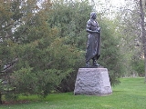
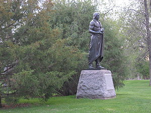
The Old Crossing Treaty Park in Huot was established on an 8.8 acres (35,612.4 m²) on the west bank of the Old Crossing site in 1933, and a memorial to the Treaty of Old Crossing (1863) was erected there on June 25, 1933. At about the same time, an additional 100 acre (0.404686 km²) on the north side of the river, which included portions of the old Pembina TrailPembina Trail
Pembina Trail is a local designation for one of the Red River ox cart trails in north western Minnesota. It refers to the easternmost of the three principal routes from Pembina and Fort Garry in the former Selkirk Colony of Manitoba to Mendota and St. Paul. A more common name for this route was...
, was acquired by citizens of Polk
Polk County, Minnesota
As of the census of 2000, there were 31,369 people, 12,070 households, and 8,050 families residing in the county. The population density was 16 people per square mile . There were 14,008 housing units at an average density of 7 per square mile...
and Red Lake counties. Today, the park includes primitive camping and picnicing facilities, seasonal historical exhibits, a boat landing and the monument to the Ojibwe treaties and Red River cart trails. It is managed by Red Lake County. *http://www.redlakerivercorridor.org/OldCrossing.htm
Cultural Events
The annual Old Crossing Arts Festival and Chautauqua is a four-day event held at Huot which is sponsored by AFRAN (Association of the French of the North), whose mission in the Red River ValleyRed River Valley
The Red River Valley is a region in central North America that is drained by the Red River of the North. It is significant in the geography of North Dakota, Minnesota, and Manitoba for its relatively fertile lands and the population centers of Fargo, Moorhead, Grand Forks, and Winnipeg...
of the North is to create an understanding of the world's French heritage through the arts and humanities. *http://lcweb2.loc.gov/cocoon/legacies/MN/200003183.html
See *http://www.harpercollege.edu/mhealy/tour/tour.htm#e5 for a description of several sites associated with Huot on the Red Lake County history tour.
Further reading
- Minnesota Historical Society, They Chose Minnesota (1981), at pp. 41–45.
- Minnesota Historical Society, The Red River Trails: Oxcart Routes Between St. Paul and the Selkirk Settlement 1820-1870, at pp. 18–19, 58-59.
- Polk County Historical Society, Bicentennial History of Polk County, Minnesota (Taylor Publishing Co., 1976), at pp. 458–59.
- Red Lake County Bicentennial Committee, A History of Red Lake County, Minnesota (Taylor Publishing Co., 1976), at pp. 8–9, 91-95, 236-37.
See also
Treaty of Old CrossingTreaty of Old Crossing
By the Treaty of Old Crossing and the Treaty of Old Crossing , the Pembina and Red Lake bands of the Ojibwe, then known as Chippewa Indians, purportedly ceded to the United States all of their rights to the Red River Valley...