Red Lake River
Encyclopedia


Minnesota
Minnesota is a U.S. state located in the Midwestern United States. The twelfth largest state of the U.S., it is the twenty-first most populous, with 5.3 million residents. Minnesota was carved out of the eastern half of the Minnesota Territory and admitted to the Union as the thirty-second state...
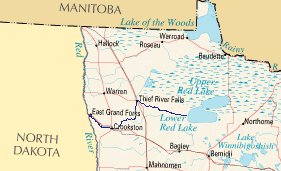
. The river begins on the western side of the Lower Red Lake
Lower Red Lake
Lower Red Lake is an unorganized territory in Beltrami County, Minnesota, USA.The territory is located on the Red Lake Indian Reservation, and the town of Red Lake is located in the area. The population was 5,057 at the 2000 census....
and flows westward. After passing through Thief River Falls
Thief River Falls, Minnesota
As of the census of 2000, there were 8,410 people, 3,619 households, and 2,091 families residing in the city. The population density was 1,760.0 people per square mile . There were 3,931 housing units at an average density of 822.7 per square mile...
, Red Lake Falls
Red Lake Falls, Minnesota
As of the census of 2000, there were 1,590 people, 608 households, and 380 families residing in the city. The population density was 749.7 people per square mile . There were 652 housing units at an average density of 307.4 per square mile...
, and Crookston
Crookston, Minnesota
As of the census of 2000, there were 8,192 people, 3,078 households, and 1,819 families residing in the city. The population density was 1,658.8 people per square mile . There were 3,382 housing units at an average density of 684.8 per square mile...
, the river merges with the Red River of the North
Red River of the North
The Red River is a North American river. Originating at the confluence of the Bois de Sioux and Otter Tail rivers in the United States, it flows northward through the Red River Valley and forms the border between the U.S. states of Minnesota and North Dakota before continuing into Manitoba, Canada...
in East Grand Forks
East Grand Forks, Minnesota
-K-12:The East Grand Forks School District enrolls over 1,000 students and operates two elementary schools , Central Middle School, and East Grand Forks Senior High School. There are also two private Christian schools. Sacred Heart School is a Roman Catholic elementary, middle, and high school...
. The total length of the river is 193 miles (310.6 km). The term "Forks" in Grand Forks comes from this forking (confluence
Confluence
Confluence, in geography, describes the meeting of two or more bodies of water.Confluence may also refer to:* Confluence , a property of term rewriting systems...
) of the Red and Red Lake rivers near downtown
Downtown Grand Forks
Downtown Grand Forks is the original commercial center of Grand Forks, North Dakota. Located on the western bank of the Red River of the North, the downtown neighborhood is situated near the fork of the Red River and the Red Lake River. While downtown is no longer the dominant commercial area of...
Grand Forks
Grand Forks, North Dakota
Grand Forks is the third-largest city in the U.S. state of North Dakota and the county seat of Grand Forks County. According to the 2010 census, the city's population was 52,838, while that of the city and surrounding metropolitan area was 98,461...
.
As a tributary of the Red River, the Red Lake River contributed to the heavy flooding of Greater Grand Forks
Greater Grand Forks
According to the 2006–2008 American Community Survey, the population of the Greater Grand Forks metro area was 97,260, of which 50.9% were male and 49.1% were female.-Age:* Under 5 years: 6.3%* 5–9 years: 5.5%* 10–14 years: 6.1%* 15–19 years: 9.6%...
in 1997. The river also caused damage in its own right, albeit less severe, in Crookston.
The Red Lake River is a popular source of recreation for area residents, and many enjoy the tubing
Tubing (recreation)
Tubing is a recreational activity where an individual rides on top of an inner tube, either on water, snow, or through the air. The tubes themselves are also known as "donuts" or "biscuits" due to their shape.-Water:Tubing on water generally consists of two forms: towed and free-floating, also...
and canoeing
Canoeing
Canoeing is an outdoor activity that involves a special kind of canoe.Open canoes may be 'poled' , sailed, 'lined and tracked' or even 'gunnel-bobbed'....
the river makes possible.
Terrain
The Red Lake River covers a wide variety of terrain. After leaving the Red Lake, the river flows through a marsh in the Red Lake Indian Reservation. The river then flows through a prairie, then through farmland. After St. HilaireSt. Hilaire, Minnesota
St. Hilaire is a city in section 6 of River Falls Township in Pennington County, Minnesota, United States. The population was 279 at the 2010 census.-History:...
the sides of the river grow steeper, becoming large eroding cliffs. Parts of the riverbanks are thickly forested.
The river is relatively smooth for most of the trip. There is a stretch between St. Hilaire and Crookston where there is a chain of rapids, which are easily navigated.
The Red Lake River is one of the few Minnesota state canoe routes in the area. There are a number of rest areas and camping facilities along the route.
Dams
The Minnesota State Department of Natural Resources (MN DNR) website (see References section) describing the nature of the river mentions three dams on the river (note that this is not be taken as the total number of dams and/or structures located on this river):- At river mile 181
- City of Red Lake Falls (dam owned by Otter Tail Power Company)
- City of Crookston (dam owned by Otter Tail Power Company)
Note: The Otter Tail Power Company
Otter Tail Power Company
Otter Tail Corporation is an energy company based in Fergus Falls, Minnesota. Its main subsidiary is the Otter Tail Power Company.As of 2007, Otter Tail Power Company serves at least 423 towns at retail and delivers power to about 14 municipal utilities...
site does not list the above 2 dams as a source of hydropower.

