

Hunter Valley floods of 1955
Encyclopedia
Flood
A flood is an overflow of an expanse of water that submerges land. The EU Floods directive defines a flood as a temporary covering by water of land not normally covered by water...
on the Hunter River in New South Wales
New South Wales
New South Wales is a state of :Australia, located in the east of the country. It is bordered by Queensland, Victoria and South Australia to the north, south and west respectively. To the east, the state is bordered by the Tasman Sea, which forms part of the Pacific Ocean. New South Wales...
, Australia
Australia
Australia , officially the Commonwealth of Australia, is a country in the Southern Hemisphere comprising the mainland of the Australian continent, the island of Tasmania, and numerous smaller islands in the Indian and Pacific Oceans. It is the world's sixth-largest country by total area...
. They were one of the most devastating natural disasters in Australia's history.
The flood overwhelmed rivers on both sides of the Great Dividing Range, creating an inland sea the size of England and Wales.
Worst hit was the inland city of Maitland
Maitland, New South Wales
Maitland is a city in the Lower Hunter Valley of New South Wales, Australia and the seat of Maitland City Council, situated on the Hunter River approximately by road north of Sydney and north-west of Newcastle...
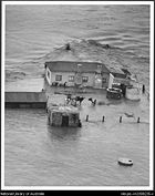
, which is sited precariously on low-lying land on the Hunter, was completely inundated by floodwaters. A total of 25 lives were claimed during a week of flooding that washed away 58 homes and damaged 103 beyond repair. In Maitland alone, 2180 homes were invaded by water.
Background
Heavy rain owing to the influence of La NiñaLa Niña
La Niña is a coupled ocean-atmosphere phenomenon that is the counterpart of El Niño as part of the broader El Niño-Southern Oscillation climate pattern. During a period of La Niña, the sea surface temperature across the equatorial Eastern Central Pacific Ocean will be lower than normal by 3–5 °C...
had been occurring over the catchment of the Hunter River
Hunter River
The Hunter River is a major river in New South Wales, Australia. The Hunter River rises in the Liverpool Range and flows generally south and then east, reaching the Pacific Ocean at Newcastle, the second largest city in New South Wales and a major port....
since October 1954 when, on 23 February 1955, an extremely intense monsoon
Monsoon
Monsoon is traditionally defined as a seasonal reversing wind accompanied by corresponding changes in precipitation, but is now used to describe seasonal changes in atmospheric circulation and precipitation associated with the asymmetric heating of land and sea...
al depression
Cyclone
In meteorology, a cyclone is an area of closed, circular fluid motion rotating in the same direction as the Earth. This is usually characterized by inward spiraling winds that rotate anticlockwise in the Northern Hemisphere and clockwise in the Southern Hemisphere of the Earth. Most large-scale...
developed over southern Queensland
Queensland
Queensland is a state of Australia, occupying the north-eastern section of the mainland continent. It is bordered by the Northern Territory, South Australia and New South Wales to the west, south-west and south respectively. To the east, Queensland is bordered by the Coral Sea and Pacific Ocean...
and moved southwards. The very strong and extremely moist northeasterly airflow meant that over the basin of the Hunter and parts of the Darling River
Darling River
The Darling River is the third longest river in Australia, measuring from its source in northern New South Wales to its confluence with the Murray River at Wentworth, New South Wales. Including its longest contiguous tributaries it is long, making it the longest river system in Australia.The...
, rainfall amounts for a 24 hour period were the highest since instrumental records began around 1885. Around Coonabarabran, as much as 327 millimetres (over 13 inches) fell in a single day, whilst falls in the upper part of the Hunter Basin the following day were generally around 200 millimetres (8 inches).
Flooding
With such heavy rain on already very wet ground the Hunter, along with tributaries of the Darling (CastlereaghCastlereagh River
The Castlereagh River is located in the State of New South Wales, Australia. The river rises in the heart of the Warrumbungle mountains and initially flows east through the town of Coonabarabran...
, Namoi
Namoi River
The Namoi River is a major tributary of the Darling River in inland New South Wales, Australia.- Course :The headwaters of the Namoi, including the Macdonald River, the Peel River, the Cockburn River and the Manilla River, rise on the western slopes of the Great Dividing Range on the Northern...
and Macquarie
Macquarie River
The Macquarie River is one of the main inland rivers in New South Wales. Its headwaters rise in the central highlands of New South Wales near the town of Oberon. The river travels generally northwest past the towns of Bathurst, Wellington, Dubbo, Narromine, and Warren to the Macquarie Marshes...
especially) reached levels quite unprecedented since measurements were first taken about 100 years earlier. For instance, the Namoi's discharge, normally only about 25 cubic metres (875 cubic feet) per second, reached a massive 9000 cubic metres (320,000 cubic feet) per second, whilst the Macquarie peaked at around 6100 cubic metres (215,000 cubic feet) per second.
In Maitland
Maitland, New South Wales
Maitland is a city in the Lower Hunter Valley of New South Wales, Australia and the seat of Maitland City Council, situated on the Hunter River approximately by road north of Sydney and north-west of Newcastle...
the Hunter exceeded its August 1952 record height by nearly a metre, flooding some homes with as much as five metres of muddy water. 15,000 people were evacuated, most by boat or helicopter
Helicopter
A helicopter is a type of rotorcraft in which lift and thrust are supplied by one or more engine-driven rotors. This allows the helicopter to take off and land vertically, to hover, and to fly forwards, backwards, and laterally...
, whilst 31 homes were never rebuilt. In Dubbo, four thousand residents were evacuated as the main street was under more than a metre of turgid, muddy water, and the same thing occurred all along the Macquarie River, and at Gilgandra
Gilgandra, New South Wales
Gilgandra, is a town and Local Government Area in the Central West region of New South Wales, Australia. It is located on the junction of the Newell Highway, Oxley Highway and Castlereagh Highway. It can be reached in about six hours by car from Sydney. Like Coonabarabran, Gilgandra can be...
, a third of the buildings were completely destroyed and a hole torn in the main street was later found to contain two large semi-trailers!
The floods took altogether the lives of 25 people. Some 2,000 cattle and many thousands of head of other livestock were drowned. The damage to bridges, roads, railways and telephone lines took months to repair. There also were millions of dollars of crops destroyed.
Timeline
Below in a timeline of the six days over which Maitland was ravaged by floodwaters:- 24 February 1955 - Torrential rain covers the Hunter Valley. Flights are cancelled at Williamtown Airport. First lives are lost as floodwaters submerge Singleton, stranding 600 people at the railway station and convent. People living in low-lying areas of Maitland are warned of imminent evacuation as water rises across the valley and an emergency declared. During the night, Muswellbrook in the Upper Hunter goes under water and a mail train crashes into floodwaters at Togar.
- 25 February 1955 - 1100 people stand stranded on the platform at Singleton Railway Station as the Hunter River begins to overflow in the Maitland suburb of Bolwarra. The main crossing over the river, the Belmore Bridge, is closed at 8:30am and evacuation of the city begins. The Mayor of Maitland warns of an approaching "wall of water" at 11am as the first major levee failures occur, first at Oakhampton where homes are instantly ripped from their foundations. Before nightfall, water is 2 m deep on the city's main thoroughfare, High Street. Five men are swept to their deaths across the city, three at the railway station. During the night, floodwaters thunder through the city. 21 homes are washed away on one residential street alone, many occupants still inside or clinging to rooftops. Only female victim of the flood, Elizabeth Dickson is swept to her death in pitch darkness.
- 26 February 1955 - Surfboats rescue hundreds across the city while a helicopter hits power lines in Maitland and electrocutes three who were being taken to safety while they dangled from a rope. The helicopter exploded. Nearby Raymond TerraceRaymond Terrace, New South WalesRaymond Terrace is a town in the Hunter Region of New South Wales, Australia, about by road north of Newcastle on the Pacific Highway. Established in 1837 it is situated at the confluence of the Hunter and Williams rivers and has about 12,600 residents. It is the administrative centre of the Port...
is hit hard while flooding extends across the valley. The entire township of Hexham, situated between Maitland and Newcastle on the Hunter River, is completely submerged and every resident evacuated. Floodwaters affect Newcastle and bring disruptions to industry and bring about evacuations in several suburbs, particularly Birmingham Gardens.
- 27 February 1955 - Thousands homeless, refugees taken to Greta migrant camp and homes all over the Hunter Valley as water levels remain at a historic high.
- 28 February 1955 - Water begins to subside, leaving thick layers of stinking silt and debris. Clean-up begins as areas begin to emerge from the floodwaters. Samuel Upton is found drowned in his Maitland home while refugees continue to be moved to Greta by the thousands.
- 29 February 1955 - Joseph Murray drowns; the last victim of the flood.