

Holywell, Eastbourne
Encyclopedia

Meads
Meads is an area of the town of Eastbourne in the English county of East Sussex. It is situated at the westerly end of the town below the South Downs.- Boundaries :...
, the latter a district of Eastbourne
Eastbourne
Eastbourne is a large town and borough in East Sussex, on the south coast of England between Brighton and Hastings. The town is situated at the eastern end of the chalk South Downs alongside the high cliff at Beachy Head...
in the county of East Sussex
East Sussex
East Sussex is a county in South East England. It is bordered by the counties of Kent, Surrey and West Sussex, and to the south by the English Channel.-History:...
, UK. Holywell has no specific boundaries, but lies approximately between the western end of the lower promenade and the chalk pinnacle below St Bedes Preparatory School.
History
William Figg’s 1816 map of Eastbourne shows an area called Holly Well Furlong near what was until 1896 the Hollywell fishing hamletHamlet
The Tragical History of Hamlet, Prince of Denmark, or more simply Hamlet, is a tragedy by William Shakespeare, believed to have been written between 1599 and 1601...
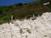
. This settlement was by the low cliff edge, above the place where fresh water emerges from the chalk. Below the chalk at this point lies an impervious stratum of gault which causes the rainwater which has seeped through the chalk to spill out almost at sea level. The fishing settlement was approached from what is now Holywell Road via the lane between the present Helen Gardens and St Bede's Preparatory School. On the left side of this lane, opposite the present sports complex of St Bede's School, stood Holywell House - said to have been an inn at one time. The house was standing as early as 1839 and demolished in about 1897.
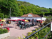
In 1905, the town council laid out a public garden, named somewhat loosely The Holywell Retreat, on the site of a disused chalk pit known as The Gore some 400 metres to the northeast of the Holywell fishing settlement. A tea chalet was later built in the garden and the area above was redesigned in the Italianate style after World War I
World War I
World War I , which was predominantly called the World War or the Great War from its occurrence until 1939, and the First World War or World War I thereafter, was a major war centred in Europe that began on 28 July 1914 and lasted until 11 November 1918...
to provide work for the unemployed. The Council later erected beach chalets above the lower promenade. In 1935, one of the chalets was set aside for the use of King George V
George V of the United Kingdom
George V was King of the United Kingdom and the British Dominions, and Emperor of India, from 6 May 1910 through the First World War until his death in 1936....
and Queen Mary
Mary of Teck
Mary of Teck was the queen consort of the United Kingdom and the British Dominions, and Empress of India, as the wife of King-Emperor George V....
during their visit to the town. More chalets were constructed in the 1950s; there were 69 brick-built chalets available for annual rent.
Second World War
During the Second World War, Canadian troops in Eastbourne set up a rife range in Whitbread Hollow, although their official War Diaries refer to this as the 'Holywell Range'. The targets were near the cliff edge and sentries were posted to ensure range safety. Cliff scaling exercises were also carried out here. The Canadians also referred to the 'Hollywell gun position' which was the site of a BoforsBofors
The name Bofors has been associated with the iron industry for more than 350 years.Located in Karlskoga, Sweden, the company originates from the hammer mill "Boofors" founded 1646. The modern corporate structure was created in 1873 with the foundation of Aktiebolaget Bofors-Gullspång...
anti-aircraft gun; again this was some distance from what is commonly known as Holywell, being situated on the footpath at the western end of the seafront - an area known locally as the Foot of Beachy Head
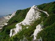
Beachy Head
Beachy Head is a chalk headland on the south coast of England, close to the town of Eastbourne in the county of East Sussex, immediately east of the Seven Sisters. The cliff there is the highest chalk sea cliff in Britain, rising to 162 m above sea level. The peak allows views of the south...
.
Etymology
Some historians trying to find a reason for the name Holy Well have associated it with the Chapel of St Gregory which is presumed to have existed near the South Cliff Tower in Bolsover Road. This, however, is some way distant from the present Holywell. The fresh water springs issuing from the low cliffs below the fishing settlement are mentioned in James Royer’s 1787 guide, Eastbourne – A Descriptive Account of that Village. The guide reports that ‘one of the springs is called Holy-well, supposed to be so named from the many advantages received from drinking those waters.’ In 1861, another book, Eastbourne as a Resort for Invalides [sic] states: "At Holywell there is a chalybeateChalybeate
Chalybeate waters, also known as ferruginous waters, are mineral spring waters containing salts of iron.-Name:The word "chalybeate" is derived from the Latin word for steel, "chalybs", which follows from the Greek word "khalups"...
spring, the curative properties of which have given the name of the Holy Well.' However, a subsequent analysis of the water demonstrated that it had no particular ‘curative properties". The original meaning of ‘well’ is a place where water welled out of the ground – in other words, a spring.
There are therefore two possible origins of the name Holywell. It could have been the spring used by a holy man or a spring close to a holly tree. However, the persistence of the local pronunciation ('holly well') would appear to favour the latter.
Chalk Pit Cottages
Weircombe Cottage
Weircombe Cottage is shown on higher ground to the east of the Pinnacle in the 1875 map. This seems to have had no connection with the fishermen's cottages. During the inter-war years, it was occupied by the actress and singer Winifred Barnes (b.1892 - d.1935), and her sister. The latter continued to live at the cottage after the death of Winifred. By that time it was the property of the Council, who finally demolished it in the 1970s.Holywell and Eastbourne’s water supply
Eastbourne’s original water supply was derived from the spring and pond in the old town at Motcombe. In 1857 a reservoir was created in what is now Motcombe Gardens; two years later the Eastbourne Waterworks Company was founded by the 7th Duke of DevonshireDuke of Devonshire
Duke of Devonshire is a title in the peerage of England held by members of the Cavendish family. This branch of the Cavendish family has been one of the richest and most influential aristocratic families in England since the 16th century, and have been rivalled in political influence perhaps only...
and this enterprise took over the Motcombe reservoir. Prior to 1896, the main water supply for the town had been drawn from the Bedford Well, near the present Whitley Road railway bridge. Pumping had started here in 1883, an inauguration attended by the future King Edward VII and Queen Alexandra. However, in the autumn of 1895, complaints were received that the town’s water tasted brackish and a decision was taken to extract water from Holywell. One year later, the hamlet at Holywell was taken over by the local water board. Rumours abounded that the womenfolk had sold their cottages to the water board while their husbands were out at sea, but the community was moved for reasons of public health — human habitation could not be countenanced on top of a water catchment area.
The water board's successors still own the site, and there is a pumping station but little evidence of the hamlet itself, as by now even most of the foundations of the cottages have gone over the cliff.
Telegraph cable
In May 1940, HMS Jaguar
HMS Jaguar
Two ships of the British Royal Navy have been named HMS Jaguar, after the feline jaguar.* The first Jaguar was a J-class destroyer launched in 1938 and sunk 1942 by U-652....
was involved in ‘Operation Quixote’ when the six telegraph cables between the East Coast of England and the German islands of Borkum
Borkum
Borkum is an island and a municipality in the Leer District in Lower Saxony, northwestern Germany.-Geography:Borkum is bordered to the west by the Westerems strait , to the east by the Osterems strait, to the north by the North Sea, and to the south by the Wadden Sea...
and Nordeney were severed. A signal from the Admiralty
Admiralty
The Admiralty was formerly the authority in the Kingdom of England, and later in the United Kingdom, responsible for the command of the Royal Navy...
dated 12 June 1940 ordered that four other cables which had not been cut during ‘Quixote’ should now be dealt with as they had only been cut on the beach. One of those cut on the beach was the "Holywell – Dieppe
Dieppe, Seine-Maritime
Dieppe is a commune in the Seine-Maritime department in France. In 1999, the population of the whole Dieppe urban area was 81,419.A port on the English Channel, famous for its scallops, and with a regular ferry service from the Gare Maritime to Newhaven in England, Dieppe also has a popular pebbled...
Telegraph Cable (1861–1922)"; the three others ran from the Cuckmere to Le Havre
Le Havre
Le Havre is a city in the Seine-Maritime department of the Haute-Normandie region in France. It is situated in north-western France, on the right bank of the mouth of the river Seine on the English Channel. Le Havre is the most populous commune in the Haute-Normandie region, although the total...
and had been laid in 1900 (Western Union), 1917 and 1918.
Dangerous rusting strands of the old cable could still be seen on the beach in the early 1950s. These have since been removed and a careful search of the terminal building in 2004 revealed no vestiges whatsoever of cable or terminal equipment.
External links
- http://www.eastbournecousins.com/cottages.htm Pictures of Chalk Pit Cottages and history of Boniface family, Eastbourne boatmen
- http://www.npg.org.uk/live/search/portrait.asp?search=as&grp=1096%3BSingers&lDate=&LinkID=mp61485&role=sit&rNo=0 Pictures of Winifred Barnes at Weircombe Cottage in 1924