
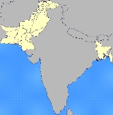
Historical regions of Pakistan
Encyclopedia
The former administrative units of Pakistan are states, provinces and territories which mainly existed between 1947 and 1975 when the current provinces and territories were established. The former units have no administrative function today but some remain as historical and cultural legacies. In some cases, the current provinces and territories correspond to the former units - for example the province of Punjab
includes almost all the territory of the former province of West Punjab
.
. The eastern wing comprised the single province of East Pakistan
, which included the Sylhet District
from the former Indian province
of Assam
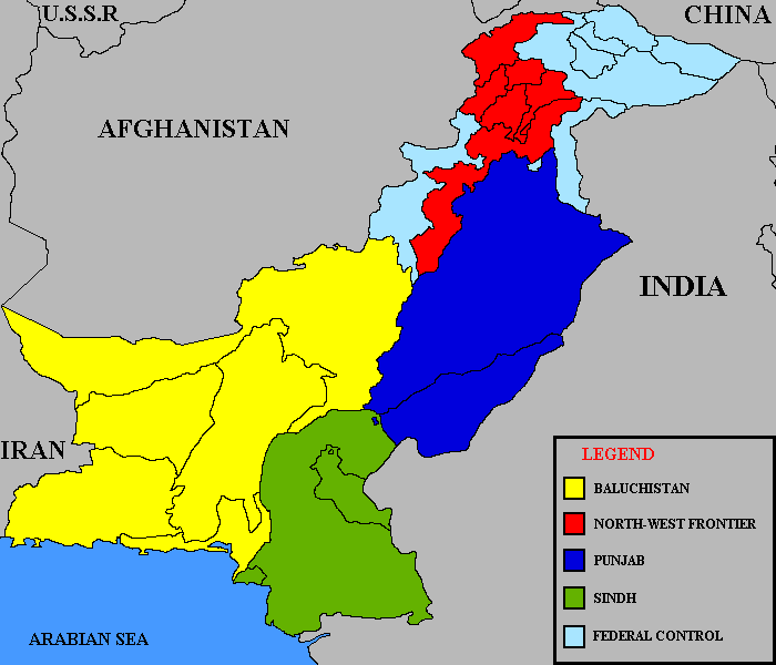
. The politically dominant western wing united three Governor's provinces (North-West Frontier Province
(NWFP), West Punjab
and Sind), one Chief Commissioner's Province (Baluchistan), several princely states and parts of Kashmir
. In 1948, the area around Karachi
was separated from Sind province to form the Federal Capital Territory
. In 1950 the North-West Frontier Province
was expanded to include the small states of Amb
and Phulra
and the name of West Punjab province was changed to Punjab. The Baluchistan States Union
was formed in 1952 by the four princely states of southwest Pakistan. Thus, between 1947 and 1955, Pakistan comprised five provinces and one territory:
The western wing included thirteen princely states, one union of states and parts of Kashmir:
policy announced by Prime Minister
Chaudhry Muhammad Ali
. The states and provinces of the western wing were merged in 1955, to become divisions of the new province of West Pakistan
with the provincial capital at Lahore
. At the same time, East Bengal became the new province of East Pakistan with the provincial capital at Dhaka. West Pakistan annexed the former Oman
i enclave of Gwadar
in 1958 as part of Kalat division. In 1960 the federal government was moved from Karachi to Rawalpindi
(provisional capital until Islamabad was completed), whilst the federal legislature moved to Dhaka. The Federal Capital Territory was merged with West Pakistan in 1961 to form the new division of Karachi. In 1963 the Trans-Karakoram Tract
was transferred by treaty from Gilgit Agency to China
under the proviso that the settlement was subject to the final solution of the Kashmir dispute. Thus from 1955 to 1970, Pakistan comprised two provinces:
and four new provinces were created along with some changes in Pakistani Kashmir. These provinces combined most of the former provinces and states as follows:
. The states of Hunza
and Nagar were abolished and their territories merged into the Gilgit-Baltistan in 1974. The Federally Administered Tribal Areas
were formed from parts of the North West Frontier Province districts of Peshawar
and Dera Ismail Khan
in 1975.
The status of the Islamabad area was changed to a capital territory in 1981. The names of two provinces were slightly modified in 1990 - Baluchistan became Balochistan and Sind became Sindh. In 2010, the North West Frontier Province changed its name to Khyber Pakhtunkhwa.
Punjab (Pakistan)
Punjab is the most populous province of Pakistan, with approximately 45% of the country's total population. Forming most of the Punjab region, the province is bordered by Kashmir to the north-east, the Indian states of Punjab and Rajasthan to the east, the Pakistani province of Sindh to the...
includes almost all the territory of the former province of West Punjab
West Punjab
West Punjab was a province of Pakistan from 1947 to 1955. The province covered an area of 160,622 km², including much of the current Punjab province and the Islamabad Capital Territory, but excluding the former princely state of Bahawalpur. The capital was the city of Lahore and the province...
.
After Independence
The origins of most of the former administrative units lay in the set-up inherited from British India. From 1947 to 1971 newly-independent Pakistan comprised two "wings" - 1600 kilometres apart and separated by IndiaIndia
India , officially the Republic of India , is a country in South Asia. It is the seventh-largest country by geographical area, the second-most populous country with over 1.2 billion people, and the most populous democracy in the world...
. The eastern wing comprised the single province of East Pakistan
East Pakistan
East Pakistan was a provincial state of Pakistan established in 14 August 1947. The provincial state existed until its declaration of independence on 26 March 1971 as the independent nation of Bangladesh. Pakistan recognized the new nation on 16 December 1971. East Pakistan was created from Bengal...
, which included the Sylhet District
Sylhet District
The district of Sylhet consists 6754 mosques, 453 temples, 96 churches and four Buddhist temples.-Places of Interests:-Historical:#The Shrine of Hazrat Shah Jalal#The Shrine of Hazrat Shah Paran#Shahi Eidgah#Gour Govinda Fort#Kean Bridge...
from the former Indian province
Provinces of India
Provinces of India, earlier Presidencies of British India, still earlier, Presidency towns, and collectively British India, were the administrative units of the territories of India under the tenancy or the sovereignty of either the East India Company or the British Crown between 1612 and...
of Assam
Assam
Assam , also, rarely, Assam Valley and formerly the Assam Province , is a northeastern state of India and is one of the most culturally and geographically distinct regions of the country...
. The politically dominant western wing united three Governor's provinces (North-West Frontier Province
North-West Frontier Province (historical)
The North-West Frontier Province was a former province of British India and then Pakistan which was established in 1901 and dissolved in 1955. The province covered an area of 70,709 km² including much of the current Khyber Pakhtunkhwa province but excluding the former princely states of Amb,...
(NWFP), West Punjab
West Punjab
West Punjab was a province of Pakistan from 1947 to 1955. The province covered an area of 160,622 km², including much of the current Punjab province and the Islamabad Capital Territory, but excluding the former princely state of Bahawalpur. The capital was the city of Lahore and the province...
and Sind), one Chief Commissioner's Province (Baluchistan), several princely states and parts of Kashmir
Kashmir
Kashmir is the northwestern region of the Indian subcontinent. Until the mid-19th century, the term Kashmir geographically denoted only the valley between the Great Himalayas and the Pir Panjal mountain range...
. In 1948, the area around Karachi
Karachi
Karachi is the largest city, main seaport and the main financial centre of Pakistan, as well as the capital of the province of Sindh. The city has an estimated population of 13 to 15 million, while the total metropolitan area has a population of over 18 million...
was separated from Sind province to form the Federal Capital Territory
Federal Capital Territory (Pakistan)
The Federal Capital Territory around Karachi was the original capital territory of Pakistan. The FCT was created in 1948 from the city of Karachi and surrounding areas as the location for Pakistan's capital following independence...
. In 1950 the North-West Frontier Province
North-West Frontier Province (historical)
The North-West Frontier Province was a former province of British India and then Pakistan which was established in 1901 and dissolved in 1955. The province covered an area of 70,709 km² including much of the current Khyber Pakhtunkhwa province but excluding the former princely states of Amb,...
was expanded to include the small states of Amb
Amb (princely state)
Amb was a princely state of the former British Indian Empire. In 1947, by the Indian Independence Act 1947, the British abandoned their supremacy, and following the Partition of India Amb's Nawab decided to give up his state's independence by acceding to the new country of Pakistan...
and Phulra
State of Phulra
Phulra was a minor princely state of both Pakistan and British India, located in the former North West Frontier province now Khyber-Pakhtunkhwa. It was situated east of the nearby princely Amb. In 1950, Phulra was merged into the NWFP as was some territory of Amb...
and the name of West Punjab province was changed to Punjab. The Baluchistan States Union
Baluchistan States Union
The Baluchistan States Union existed between 3 October 1952 and 14 October 1955 in southwest Pakistan. It was formed by the states of Kalat, Kharan, Las Bela and Makran with the capital at the town of Kalat. The area of the Union was roughly the western half of the modern province of Balochistan...
was formed in 1952 by the four princely states of southwest Pakistan. Thus, between 1947 and 1955, Pakistan comprised five provinces and one territory:
 Federal Capital Federal Capital Territory (Pakistan) The Federal Capital Territory around Karachi was the original capital territory of Pakistan. The FCT was created in 1948 from the city of Karachi and surrounding areas as the location for Pakistan's capital following independence... |
Baluchistan Baluchistan (Chief Commissioners Province) The Chief Commissioner's Province of Baluchistan was a province of British India located in the northern parts of the modern Balochistan province.- History :... |
East Pakistan East Pakistan East Pakistan was a provincial state of Pakistan established in 14 August 1947. The provincial state existed until its declaration of independence on 26 March 1971 as the independent nation of Bangladesh. Pakistan recognized the new nation on 16 December 1971. East Pakistan was created from Bengal... |
NWFP North-West Frontier Province (historical) The North-West Frontier Province was a former province of British India and then Pakistan which was established in 1901 and dissolved in 1955. The province covered an area of 70,709 km² including much of the current Khyber Pakhtunkhwa province but excluding the former princely states of Amb,... |
 Sind |
West Punjab West Punjab West Punjab was a province of Pakistan from 1947 to 1955. The province covered an area of 160,622 km², including much of the current Punjab province and the Islamabad Capital Territory, but excluding the former princely state of Bahawalpur. The capital was the city of Lahore and the province... |
The western wing included thirteen princely states, one union of states and parts of Kashmir:
- Baluchistan States UnionBaluchistan States UnionThe Baluchistan States Union existed between 3 October 1952 and 14 October 1955 in southwest Pakistan. It was formed by the states of Kalat, Kharan, Las Bela and Makran with the capital at the town of Kalat. The area of the Union was roughly the western half of the modern province of Balochistan...
(combining Kalat, Kharan, Las Bela and Makran - using flag of Kalat) - Gilgit AgencyGilgit AgencyThe Gilgit Agency was a political unit of British India, which administered the northern half of the Princely state of Jammu and Kashmir. The Gilgit Agency was created in 1877 and was overseen by a political agent of the Governor-General of British India. The seat of the agent was Srinagar...
(part of KashmirKashmirKashmir is the northwestern region of the Indian subcontinent. Until the mid-19th century, the term Kashmir geographically denoted only the valley between the Great Himalayas and the Pir Panjal mountain range...
)
Amb Amb (princely state) Amb was a princely state of the former British Indian Empire. In 1947, by the Indian Independence Act 1947, the British abandoned their supremacy, and following the Partition of India Amb's Nawab decided to give up his state's independence by acceding to the new country of Pakistan... |  Bahawalpur State of Bahawalpur Bahawalpur was a princely state, stretching along the southern bank of the Sutlej and Indus Rivers, with its capital city at Bahawalpur. The state was counted amongst the Rajputana states... | Chitral State of Chitral Chitral was a princely state of Pakistan and British India until 1969. The area of the state now forms the Chitral District of Khyber-Pakhtunkhwa.- Location :... |  Dir State of Dir Dir was a small located in what is today Khyber-Pakhtunkhwa province of Pakistan. The state ceased to exist in 1969, when it was incorporated into Pakistan. The area once occupied by the state, , now forms two districts of Pakistan – Upper Dir and Lower Dir... | Nagar State of Nagar Nagar was a princely state in the northernmost part of Gilgit-Baltistan in northern Pakistan, which existed until 1974. The state bordered the Gilgit Agency to the south and west, and the former princely state of Hunza to the north and east. The state capital was the town of Nagar. The area of... |  Kalat State of Kalat Kalat or Qalat was a princely state located in the centre of the modern province of Balochistan, Pakistan. The state capital was the town of Kalat.-Geography:The State of Kalat was located between 25°1′ and... |  Khayrpur State of Khayrpur The State of Khairpur was a princely state on the Indus River in what is now Pakistan, with its capital city at Khairpur. Together with Bahawalpur, the state was counted amongst the Punjab states rather than the neighbouring Rajputana states to the east.-History:thumb|left|Mir George ali Murad... |
 Kharan State of Kharan The State of Kharan was an autonomous princely state in India , located in the southwest of modern Pakistan.- History :The state of Kharan was established in about 1697 CE as a vassal state of Kalat, a status which remained until 1940. On 17 March 1948, Kharan acceded to Pakistan and on 3 October... |  Las Bela State of Las Bela Las Bela was a princely state in British India which existed until 1955. The state occupied an area of in the extreme southeast of the Balochistan province with an extensive coastline on the Arabian Sea to the south. Las Bela was bordered by the princely states of Kalat and Makran to the north... |  Makran State of Makran Makran was an autonomous princely state of both British India and Pakistan, which ceased to exist in 1955. It was located in the extreme southwest of Pakistan, an area occupied by the districts of Gwadar, Kech and Panjgur... | Nagar State of Nagar Nagar was a princely state in the northernmost part of Gilgit-Baltistan in northern Pakistan, which existed until 1974. The state bordered the Gilgit Agency to the south and west, and the former princely state of Hunza to the north and east. The state capital was the town of Nagar. The area of... | Swat State of Swat Swat was a province of the Mughal Empire ruled by local rulers known as the Akhwands, then until 1947 a princely state of the British Indian Empire, which was dissolved in 1947, when the Akhwand acceded to Pakistan... |
One-Unit System
Simmering tensions between the eastern and western wings of Pakistan led to the One UnitOne Unit
One-Unit was the title of a scheme launched by the federal government of Pakistan to merge the four provinces of West Pakistan into one homogenous unit, as a counterbalance against the numerical domination of the ethnic Bengalis of East Pakistan...
policy announced by Prime Minister
Prime Minister of Pakistan
The Prime Minister of Pakistan , is the Head of Government of Pakistan who is designated to exercise as the country's Chief Executive. By the Constitution of Pakistan, Pakistan has the parliamentary democratic system of government...
Chaudhry Muhammad Ali
Chaudhry Muhammad Ali
Chaudhry Muhammad Ali Chaudhry Muhammad Ali Chaudhry Muhammad Ali (Punjabi, ; (July 15, 1905 - December 2, 1980) was a Pakistani statesman who served as the fourth Prime Minister of Pakistan from 1955 to 1956.-Early life:...
. The states and provinces of the western wing were merged in 1955, to become divisions of the new province of West Pakistan
West Pakistan
West Pakistan , common name West-Pakistan , in the period between its establishment on 22 November 1955 to disintegration on December 16, 1971. This period, during which, Pakistan was divided, ended when East-Pakistan was disintegrated and succeeded to become which is now what is known as Bangladesh...
with the provincial capital at Lahore
Lahore
Lahore is the capital of the Pakistani province of Punjab and the second largest city in the country. With a rich and fabulous history dating back to over a thousand years ago, Lahore is no doubt Pakistan's cultural capital. One of the most densely populated cities in the world, Lahore remains a...
. At the same time, East Bengal became the new province of East Pakistan with the provincial capital at Dhaka. West Pakistan annexed the former Oman
Oman
Oman , officially called the Sultanate of Oman , is an Arab state in southwest Asia on the southeast coast of the Arabian Peninsula. It is bordered by the United Arab Emirates to the northwest, Saudi Arabia to the west, and Yemen to the southwest. The coast is formed by the Arabian Sea on the...
i enclave of Gwadar
Gwadar
Gwadar also known as Godar is a developing port city on the southwestern Arabian Sea coast of Pakistan. It is the district headquarters of Gwadar District in Balochistan province and has a population of approximately 50,000.Gwadar is strategically located at the apex of the Arabian Sea and at the...
in 1958 as part of Kalat division. In 1960 the federal government was moved from Karachi to Rawalpindi
Rawalpindi
Rawalpindi , locally known as Pindi, is a city in the Pothohar region of Pakistan near Pakistan's capital city of Islamabad, in the province of Punjab. Rawalpindi is the fourth largest city in Pakistan after Karachi, Lahore and Faisalabad...
(provisional capital until Islamabad was completed), whilst the federal legislature moved to Dhaka. The Federal Capital Territory was merged with West Pakistan in 1961 to form the new division of Karachi. In 1963 the Trans-Karakoram Tract
Trans-Karakoram Tract
The Trans-Karakoram Tract is an area of nearly along both sides of the Shaksgam River, is entirely administered by the People's Republic of China as a part of Kargilik County and Taxkorgan Tajik Autonomous County in the Kashgar Prefecture of Xinjiang Autonomous Region, but claimed by Pakistan...
was transferred by treaty from Gilgit Agency to China
China
Chinese civilization may refer to:* China for more general discussion of the country.* Chinese culture* Greater China, the transnational community of ethnic Chinese.* History of China* Sinosphere, the area historically affected by Chinese culture...
under the proviso that the settlement was subject to the final solution of the Kashmir dispute. Thus from 1955 to 1970, Pakistan comprised two provinces:
- East PakistanEast PakistanEast Pakistan was a provincial state of Pakistan established in 14 August 1947. The provincial state existed until its declaration of independence on 26 March 1971 as the independent nation of Bangladesh. Pakistan recognized the new nation on 16 December 1971. East Pakistan was created from Bengal...
- West PakistanWest PakistanWest Pakistan , common name West-Pakistan , in the period between its establishment on 22 November 1955 to disintegration on December 16, 1971. This period, during which, Pakistan was divided, ended when East-Pakistan was disintegrated and succeeded to become which is now what is known as Bangladesh...
New Provinces
The One Unit policy was regarded as a rational administrative reform to reduce expenditure and eliminate provincial prejudices. However the military coup of 1958 signalled troubled times for the two-province system as the office of Chief Minister of West Pakistan was abolished by President Ayub Khan to be replaced by Governor's rule. Eventually, in 1970, the province of West Pakistan was dissolved by President Yahya KhanYahya Khan
General Agha Mohammad Yahya Khan Qizilbash, H.Pk, HJ, S.Pk, psc was the third President of Pakistan from 1969 to 1971, following the resignation of Ayub Khan...
and four new provinces were created along with some changes in Pakistani Kashmir. These provinces combined most of the former provinces and states as follows:
| New Province | Constituent former administrative units |
|---|---|
| Baluchistan Province Balochistan (Pakistan) Balochistan is one of the four provinces or federating units of Pakistan. With an area of 134,051 mi2 or , it is the largest province of Pakistan, constituting approximately 44% of the total land mass of Pakistan. According to the 1998 population census, Balochistan had a population of... |
|
| North-West Frontier Province North-West Frontier Province Khyber Pakhtunkhwa , formerly known as the North-West Frontier Province and various other names, is one of the four provinces of Pakistan, located in the north-west of the country... |
|
| Punjab Province Punjab (Pakistan) Punjab is the most populous province of Pakistan, with approximately 45% of the country's total population. Forming most of the Punjab region, the province is bordered by Kashmir to the north-east, the Indian states of Punjab and Rajasthan to the east, the Pakistani province of Sindh to the... |
|
| Sindh Province Sindh Sindh historically referred to as Ba'ab-ul-Islam , is one of the four provinces of Pakistan and historically is home to the Sindhi people. It is also locally known as the "Mehran". Though Muslims form the largest religious group in Sindh, a good number of Christians, Zoroastrians and Hindus can... |
|
| Centrally Administered Area Islamabad Capital Territory The Islamabad Capital Territory is one of the two federal territories of Pakistan. It includes Islamabad, the capital city of Pakistan, and covers an area of 1,165.5 km² of which 906 km² is Islamabad proper... |
|
| Northern Areas |
|
Changes after 1970
The province of East Pakistan became independent in December 1971 as the new country of BangladeshBangladesh
Bangladesh , officially the People's Republic of Bangladesh is a sovereign state located in South Asia. It is bordered by India on all sides except for a small border with Burma to the far southeast and by the Bay of Bengal to the south...
. The states of Hunza
Hunza (princely state)
Hunza was a princely state in the northernmost part of the Northern Areas of Pakistan until 1974. The state was also known as Kanjut. The state bordered the Gilgit Agency to the south, the former princely state of Nagar to the east, China, to the north and Afghanistan to the northwest. The state...
and Nagar were abolished and their territories merged into the Gilgit-Baltistan in 1974. The Federally Administered Tribal Areas
Federally Administered Tribal Areas
The Federally Administered Tribal Areas are a semi-autonomous tribal region in the northwest of Pakistan, lying between the province of Khyber Pakhtunkhwa, Balochistan, and the neighboring country of Afghanistan. The FATA comprise seven Agencies and six FRs...
were formed from parts of the North West Frontier Province districts of Peshawar
Peshawar
Peshawar is the capital of Khyber-Pakhtunkhwa and the administrative center and central economic hub for the Federally Administered Tribal Areas of Pakistan....
and Dera Ismail Khan
Dera Ismail Khan
Dera Ismail Khan is a city in Khyber-Pakhtunkhwa Province, Pakistan. It is situated on the west bank of the Indus River, west of Lahore and northwest of Multan. The city is the capital of the district and tehsil of the same name. In Pakistan, its name is often abbreviated to D. I...
in 1975.
The status of the Islamabad area was changed to a capital territory in 1981. The names of two provinces were slightly modified in 1990 - Baluchistan became Balochistan and Sind became Sindh. In 2010, the North West Frontier Province changed its name to Khyber Pakhtunkhwa.