

Highway 108 (Ontario)
Encyclopedia
King's Highway 108, commonly referred to as Highway 108, is a provincially maintained highway in the Canadian
province of Ontario
. Located in the Algoma District in the remote north of the province, the highway extends for 41.6 kilometres from an intersection with Highway 17 west of Serpent River, through the urban core of Elliot Lake, to an intersection with Quirke Mine
Road in the north end of the city. The highway continues as Secondary Highway 639 north of Quirke Mine Road.
A second unrelated Highway 108 existed for approximately a year in Toronto
, following The Queensway between Highway 27 and the Queen Elizabeth Way
. Like most highways in Toronto, it was transferred to Metropolitan Toronto in 1954. The current Highway 108 was designated in 1957 and has remained more-or-less unchanged since then.
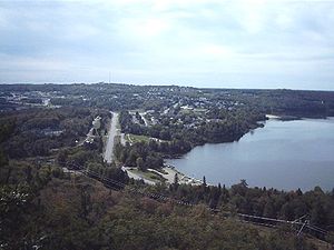
with the mines in the Elliot Lake and Quirke Lake area. Elliot Lake is the only community on the highway and is located approximately two-thirds of the distance between Highway 17 and Highway 546. The route begins at Highway 17, 6 kilometres (3.7 mi) east of Spragge and 2 kilometres (1.2 mi) west of Serpent River. It proceeds 24 kilometres (14.9 mi) north through a lake-ridden and remote wilderness before entering the built-up community of Elliot Lake.
Within Elliot Lake, the highway is locally maintained. It passes the Nuclear Mining Museum and the Mount Dufour ski resort
before leaving the community and crossing the eastern end of the geographic Elliot Lake. From this point to the northern terminus of the highway, the route provides access to several mines that dot the surrounding areas. Immediately south of Quirke Mine Road, Highway 108 becomes Secondary Highway 639; the centre lane ends and the pavement quality is visibly reduced.
Highway 108 forms part of the Deer Trail tourist route, which continues north along Highway 639, then southwest along Highway 546 to Iron Bridge.
The current iteration of Highway 108 was assumed by the Department of Highways in sections, beginning in late 1957, shortly after the discovery of Uranium
deposits in the area. Prior to is assumption, the route it followed was designated as Highway 612. The first section, located in the urbanized area of Elliot Lake, was assumed on December 19, 1957. This was followed on December 30 with the majority of the route being assumed. Finally, on January 23, 1958, the northernmost 15 kilometres (9.3 mi) of Highway 612 was designated as part of Highway 108, eliminating that highway entirely.
On January 1, 1998, a 5.7 kilometres (3.5 mi) section of the highway was transferred to the Municipality of Elliot Lake.
Canada
Canada is a North American country consisting of ten provinces and three territories. Located in the northern part of the continent, it extends from the Atlantic Ocean in the east to the Pacific Ocean in the west, and northward into the Arctic Ocean...
province of Ontario
Ontario
Ontario is a province of Canada, located in east-central Canada. It is Canada's most populous province and second largest in total area. It is home to the nation's most populous city, Toronto, and the nation's capital, Ottawa....
. Located in the Algoma District in the remote north of the province, the highway extends for 41.6 kilometres from an intersection with Highway 17 west of Serpent River, through the urban core of Elliot Lake, to an intersection with Quirke Mine
Quirke Mine
The Quirke Mine is an abandoned uranium mine located approximately 13.5 km north of Elliot Lake, Ontario, owned and operated by Rio Algom Ltd...
Road in the north end of the city. The highway continues as Secondary Highway 639 north of Quirke Mine Road.
A second unrelated Highway 108 existed for approximately a year in Toronto
Toronto
Toronto is the provincial capital of Ontario and the largest city in Canada. It is located in Southern Ontario on the northwestern shore of Lake Ontario. A relatively modern city, Toronto's history dates back to the late-18th century, when its land was first purchased by the British monarchy from...
, following The Queensway between Highway 27 and the Queen Elizabeth Way
Queen Elizabeth Way
The Queen Elizabeth Way, commonly abbreviated as the QEW, is a 400-Series highway in the Canadian province of Ontario. The freeway links Buffalo, New York and the Niagara Peninsula with Toronto. It begins at the Peace Bridge in Fort Erie and travels around the western shore of Lake Ontario, ending...
. Like most highways in Toronto, it was transferred to Metropolitan Toronto in 1954. The current Highway 108 was designated in 1957 and has remained more-or-less unchanged since then.
Route description
Highway 108 is a remote highway in Algoma District that serves to connect the Trans-Canada HighwayTrans-Canada Highway
The Trans-Canada Highway is a federal-provincial highway system that joins the ten provinces of Canada. It is, along with the Trans-Siberian Highway and Australia's Highway 1, one of the world's longest national highways, with the main route spanning 8,030 km...
with the mines in the Elliot Lake and Quirke Lake area. Elliot Lake is the only community on the highway and is located approximately two-thirds of the distance between Highway 17 and Highway 546. The route begins at Highway 17, 6 kilometres (3.7 mi) east of Spragge and 2 kilometres (1.2 mi) west of Serpent River. It proceeds 24 kilometres (14.9 mi) north through a lake-ridden and remote wilderness before entering the built-up community of Elliot Lake.
Within Elliot Lake, the highway is locally maintained. It passes the Nuclear Mining Museum and the Mount Dufour ski resort
Ski resort
A ski resort is a resort developed for skiing and other winter sports. In Europe a ski resort is a town or village in a ski area - a mountainous area, where there are ski trails and supporting services such as hotels and other accommodation, restaurants, equipment rental and a ski lift system...
before leaving the community and crossing the eastern end of the geographic Elliot Lake. From this point to the northern terminus of the highway, the route provides access to several mines that dot the surrounding areas. Immediately south of Quirke Mine Road, Highway 108 becomes Secondary Highway 639; the centre lane ends and the pavement quality is visibly reduced.
Highway 108 forms part of the Deer Trail tourist route, which continues north along Highway 639, then southwest along Highway 546 to Iron Bridge.
History
Highway 108 is Algoma is the second highway to carry the designation. In 1953, The Queensway in Toronto was assumed by the Department of Highways as the original Highway 108, between Highway 27 (now Highway 427) and the eastern end of the Queen Elizabeth Way. This designation was short lived, as all the highways within the city limits were transferred to Metropolitan Toronto in 1954.The current iteration of Highway 108 was assumed by the Department of Highways in sections, beginning in late 1957, shortly after the discovery of Uranium
Uranium
Uranium is a silvery-white metallic chemical element in the actinide series of the periodic table, with atomic number 92. It is assigned the chemical symbol U. A uranium atom has 92 protons and 92 electrons, of which 6 are valence electrons...
deposits in the area. Prior to is assumption, the route it followed was designated as Highway 612. The first section, located in the urbanized area of Elliot Lake, was assumed on December 19, 1957. This was followed on December 30 with the majority of the route being assumed. Finally, on January 23, 1958, the northernmost 15 kilometres (9.3 mi) of Highway 612 was designated as part of Highway 108, eliminating that highway entirely.
On January 1, 1998, a 5.7 kilometres (3.5 mi) section of the highway was transferred to the Municipality of Elliot Lake.
Major intersections
The following table lists the major junctions along Highway 108. The entirety of the highway is located within Algoma District.| Location | km | Destinations | Notes |
|---|---|---|---|
| The North Shore | 0.0 | ||
| Elliot Lake | 20.7 | Nordic Mine Road | Mine access road |
| 24.7 | Esten Drive South | Highway 108 ends | |
| 30.4 | Timber Road North | Highway 108 resumes | |
| 37.0 | Stanrock Mine Road | Mine access road | |
| 40.0 | Denison Mine Road | ||
| 41.0 | Panel Mine Road | ||
| 41.6 |