
Herøy, Møre og Romsdal
Encyclopedia
Herøy is a municipality in Møre og Romsdal
county
, Norway
. It is part of the Sunnmøre
region
. The administrative centre is the town of Fosnavåg
on the island of Bergsøy
a. The industrial area of Eggesbønes
is located south of Fosnavåg on the same island. The Runde Environmental Centre
is located in the northern part of the municipality on Runde
island.
). On 1 January 1867, the sub-parish of Sande
was separated from Herøy to form a municipality of its own. This left Herøy with 1,999 residents. On 1 January 1873, an area of Sande (population: 362) was transferred back to Herøy. On 1 January 1889, the Eiksund
area and Ekø island
(population: 119) were transferred from Sande to Herøy.
On 1 January 1964, three farms in the Gurskedalen
valley (population: 25) were transferred from Herøy to Sande. Also on that date, the Eiksund
area and the Eika island
(population: 222) were transferred from Herøy to Ulstein
.
) is named after a archipelago
of small islands (Old Norse
: Herøyjar). The first element is herr which means "army
" (here in the sense skipaherr which means "military fleet") and the last element is the plural
form of øy which means "island
". Before 1918, the name was written Herø.
is from modern times. They were granted in 1987. The arms show two stem
s which represent the 7th century Kvalsund boats found in the municipality.
has three parishes within the municipality of Herøy. It is part of the Diocese of Møre
and the Rural Deanery
(Prosti) of Søre Sunnmøre.
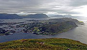 The main population and administrative centre of the municipality is the town of Fosnavåg
, located on the island of Bergsøy
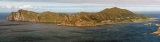
a. The municipality is entirely composed of islands, including the main islands of Bergsøy
a, Leinøy
a, Nerlandsøya
, Remøya
, Runde
, Skorpa, Flåvær
, and the eastern part of Gurskøy
a, plus many smaller islands, Runde
is especially notable for its large seabird colonies while Skorpa is famous for its role as a station for the Shetland bus
. The islands are connected together via a series of bridges including the Runde Bridge
, Remøy Bridge
, Herøy Bridge
, and Nerlandsøy Bridge
.
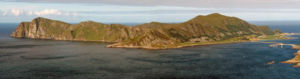
The Herøyfjord
bisects Herøy municipality. The half located south of the fjord is referred to as Inner Herøy, while the half located north of the fjord is referred to as Outer Herøy. Inner and Outer Herøy are tied together by the Herøy Bridge
which connects the islands of Gurskøy
and Leinøy
a. Along this main route of traffic is the islet Notøy and the even smaller Herøy islet, an old trading station (now museum) and the original location of the original Herøy church.
The fishing station Flåvær
is located on a group of islets and skerries
in the Herøyfjord, It includes the islets Flåvær, Husholmen, Torvholmen and Varholmen. The Flåvær lighthouse
is located on Varholmen.
The Svinøy lighthouse
is located on the very small island of Svinøy, about 12 kilometres (7.5 mi) west of the island of Skorpa.
Møre og Romsdal
is a county in the northernmost part of Western Norway. It borders the counties of Sør-Trøndelag, Oppland and Sogn og Fjordane. The county administration is located in Molde, while Ålesund is the largest city.-The name:...
county
Counties of Norway
Norway is divided into 19 administrative regions, called counties . The counties form the primary first-level subdivisions of Norway and are further divided into 430 municipalities...
, Norway
Norway
Norway , officially the Kingdom of Norway, is a Nordic unitary constitutional monarchy whose territory comprises the western portion of the Scandinavian Peninsula, Jan Mayen, and the Arctic archipelago of Svalbard and Bouvet Island. Norway has a total area of and a population of about 4.9 million...
. It is part of the Sunnmøre
Sunnmøre
Sunnmøre is the southernmost traditional district of the western Norwegian county of Møre og Romsdal. Its main city is Ålesund. The region comprises the municipalities of Giske, Hareid, Herøy, Norddal, Sande, Skodje, Haram, Stordal, Stranda, Sula, Sykkylven, Ulstein, Vanylven, Volda, Ørskog,...
region
Districts of Norway
The country Norway is historically divided into a number of districts. Many districts have deep historical roots, and only partially coincide with today's administrative units of counties and municipalities. The districts are defined by geographical features, often valleys, mountain ranges, fjords,...
. The administrative centre is the town of Fosnavåg
Fosnavåg
is a city in the municipality of Herøy in Møre og Romsdal county, Norway. It is the administrative center of the municipality of Herøy. The city is located on the island of Bergsøya which is connected to Kvalsund on the island of Nerlandsøya via the Nerlandsøy Bridge to the west...
on the island of Bergsøy
Bergsøy
Bergsøy or Bergsøya is an island in the municipality of Herøy in Møre og Romsdal county, Norway. The island is the location of the municipal center of Fosnavåg as well as the Eggesbønes industrial area. The island is connected to other islands via a network of bridges...
a. The industrial area of Eggesbønes
Eggesbønes
Eggesbønes is a village that is located in the southern part of the town of Fosnavåg in the municipality of Herøy in Møre og Romsdal county, Norway...
is located south of Fosnavåg on the same island. The Runde Environmental Centre
Runde Environmental Centre
Runde Environmental Centre is a research station at the Norwegian island of Runde. The centre has four main activities: a marine station, a house and hub for small spin-off businesses, an information centre, and a conference/overnight centre with 34 hotel-standard rooms in 8 apartment suites. The...
is located in the northern part of the municipality on Runde
Runde
Runde is an island in the municipality of Herøy in Møre og Romsdal county, Norway. The island has a population of about 90 people, and it's connected by the Runde Bridge to the island of Remøya to the south....
island.
General information
Herøy was established as a municipality on 1 January 1838 (see formannskapsdistriktFormannskapsdistrikt
Formannskapsdistrikt was the name for a Norwegian local self-government districts put into force in 1838. This system of municipality was created in a bill approved by the Storting and signed into law by King Carl Johan on 14 January 1837...
). On 1 January 1867, the sub-parish of Sande
Sande, Møre og Romsdal
Sande is a municipality in Møre og Romsdal county, Norway. It is part of the Sunnmøre region. The administrative centre is the village of Larsnes on the island of Gurskøya.-General information:...
was separated from Herøy to form a municipality of its own. This left Herøy with 1,999 residents. On 1 January 1873, an area of Sande (population: 362) was transferred back to Herøy. On 1 January 1889, the Eiksund
Eiksund
Eiksund is a village in the municipality of Ulstein in Møre og Romsdal county, Norway. It is located on the southern tip of the island of Hareidlandet...
area and Ekø island
Eika, Møre og Romsdal
Eika is an island in the municipality of Ulstein in Møre og Romsdal county, Norway. It is connected to the village of Eiksund on the island of Hareidlandet by the Eiksund Bridge. Eika is connected to the mainland of Norway by the Eiksund Tunnel....
(population: 119) were transferred from Sande to Herøy.
On 1 January 1964, three farms in the Gurskedalen
Gursken
Gursken is a village in the municipality of Sande in Møre og Romsdal county in the northwestern part of Norway. The village is situated on Gurskøya island in the southwestern part of Møre og Romsdal. Gursken church is located here. Neighboring villages are Gjerdsvika and Larsnes...
valley (population: 25) were transferred from Herøy to Sande. Also on that date, the Eiksund
Eiksund
Eiksund is a village in the municipality of Ulstein in Møre og Romsdal county, Norway. It is located on the southern tip of the island of Hareidlandet...
area and the Eika island
Eika, Møre og Romsdal
Eika is an island in the municipality of Ulstein in Møre og Romsdal county, Norway. It is connected to the village of Eiksund on the island of Hareidlandet by the Eiksund Bridge. Eika is connected to the mainland of Norway by the Eiksund Tunnel....
(population: 222) were transferred from Herøy to Ulstein
Ulstein
Ulstein is a municipality in Møre og Romsdal county, Norway. It is part of the Sunnmøre region. The commercial and administrative centre of Ulstein is Ulsteinvik, population 5,251 . The municipality occupies the western half of the island of Hareidlandet, as well as about 30 or more smaller...
.
Name
The municipality (originally the parishParish
A parish is a territorial unit historically under the pastoral care and clerical jurisdiction of one parish priest, who might be assisted in his pastoral duties by a curate or curates - also priests but not the parish priest - from a more or less central parish church with its associated organization...
) is named after a archipelago
Archipelago
An archipelago , sometimes called an island group, is a chain or cluster of islands. The word archipelago is derived from the Greek ἄρχι- – arkhi- and πέλαγος – pélagos through the Italian arcipelago...
of small islands (Old Norse
Old Norse
Old Norse is a North Germanic language that was spoken by inhabitants of Scandinavia and inhabitants of their overseas settlements during the Viking Age, until about 1300....
: Herøyjar). The first element is herr which means "army
Army
An army An army An army (from Latin arma "arms, weapons" via Old French armée, "armed" (feminine), in the broadest sense, is the land-based military of a nation or state. It may also include other branches of the military such as the air force via means of aviation corps...
" (here in the sense skipaherr which means "military fleet") and the last element is the plural
Plural
In linguistics, plurality or [a] plural is a concept of quantity representing a value of more-than-one. Typically applied to nouns, a plural word or marker is used to distinguish a value other than the default quantity of a noun, which is typically one...
form of øy which means "island
Island
An island or isle is any piece of sub-continental land that is surrounded by water. Very small islands such as emergent land features on atolls can be called islets, cays or keys. An island in a river or lake may be called an eyot , or holm...
". Before 1918, the name was written Herø.
Coat-of-arms
The coat-of-armsCoat of arms
A coat of arms is a unique heraldic design on a shield or escutcheon or on a surcoat or tabard used to cover and protect armour and to identify the wearer. Thus the term is often stated as "coat-armour", because it was anciently displayed on the front of a coat of cloth...
is from modern times. They were granted in 1987. The arms show two stem
Stem (ship)
The stem is the very most forward part of a boat or ship's bow and is an extension of the keel itself and curves up to the wale of the boat. The stem is more often found on wooden boats or ships, but not exclusively...
s which represent the 7th century Kvalsund boats found in the municipality.
Churches
The Church of NorwayChurch of Norway
The Church of Norway is the state church of Norway, established after the Lutheran reformation in Denmark-Norway in 1536-1537 broke the ties to the Holy See. The church confesses the Lutheran Christian faith...
has three parishes within the municipality of Herøy. It is part of the Diocese of Møre
Diocese of Møre
The Diocese of Møre is a diocese in the Church of Norway which geographically consists of Møre og Romsdal county, Norway. Its bishop and cathedral are located in the county administrative center of Molde...
and the Rural Deanery
Deanery
A Deanery is an ecclesiastical entity in both the Roman Catholic Church and the Church of England. A deanery is either the jurisdiction or residence of a Dean.- Catholic usage :...
(Prosti) of Søre Sunnmøre.
| Parish (Sokn) | Church Name | Year Built | Location of the Church |
|---|---|---|---|
| Herøy | Herøy kyrkje | 2003 | Fosnavåg Fosnavåg is a city in the municipality of Herøy in Møre og Romsdal county, Norway. It is the administrative center of the municipality of Herøy. The city is located on the island of Bergsøya which is connected to Kvalsund on the island of Nerlandsøya via the Nerlandsøy Bridge to the west... |
| Indre Herøy | Indre Herøy kyrkje | 1916 | Indre Herøy |
| Leikanger | Leikanger kyrkje | 1807 | Leikanger |
Geography
Fosnavåg
is a city in the municipality of Herøy in Møre og Romsdal county, Norway. It is the administrative center of the municipality of Herøy. The city is located on the island of Bergsøya which is connected to Kvalsund on the island of Nerlandsøya via the Nerlandsøy Bridge to the west...
, located on the island of Bergsøy
Bergsøy
Bergsøy or Bergsøya is an island in the municipality of Herøy in Møre og Romsdal county, Norway. The island is the location of the municipal center of Fosnavåg as well as the Eggesbønes industrial area. The island is connected to other islands via a network of bridges...
a. The municipality is entirely composed of islands, including the main islands of Bergsøy
Bergsøy
Bergsøy or Bergsøya is an island in the municipality of Herøy in Møre og Romsdal county, Norway. The island is the location of the municipal center of Fosnavåg as well as the Eggesbønes industrial area. The island is connected to other islands via a network of bridges...
a, Leinøy
Leinøy
Leinøy or Leinøya is an island in the municipality of Herøy in Møre og Romsdal county, Norway. Its original name was Bølandet, but Leinøy is now the common name. The island is located east of the municipal center of Fosnavåg. The island is connected to other islands via a network of bridges...
a, Nerlandsøya
Nerlandsøya
Nerlandsøya is an island in the municipality of Herøy in Møre og Romsdal county, Norway. The island is located northwest of the municipal center of Fosnavåg and east of the island of Skorpa. The island is connected to the island Bergsøya by the Nerlandsøy Bridge. The Flåvær islands lie to the...
, Remøya
Remøya
Remøya is an island in the municipality of Herøy in Møre og Romsdal county, Norway. The island is located north of the municipal center of Fosnavåg. The island is connected to other islands via a network of bridges. The Remøy Bridge connects it to the island Leinøya and the Runde Bridge connects...
, Runde
Runde
Runde is an island in the municipality of Herøy in Møre og Romsdal county, Norway. The island has a population of about 90 people, and it's connected by the Runde Bridge to the island of Remøya to the south....
, Skorpa, Flåvær
Flåvær
Flåvær is group of islets and skerries in the Herøyfjord in the municipality of Herøy in Møre og Romsdal county, Norway. The islands are located north of the island Gurskøy and southwest of Fosnavåg...
, and the eastern part of Gurskøy
Gurskøy
Gurskøy is an island in the municipalities of Sande and Herøy in Møre og Romsdal county, Norway. The island has an area of . The villages of Gursken, Larsnes, and Moldtustranda are located on the island...
a, plus many smaller islands, Runde
Runde
Runde is an island in the municipality of Herøy in Møre og Romsdal county, Norway. The island has a population of about 90 people, and it's connected by the Runde Bridge to the island of Remøya to the south....
is especially notable for its large seabird colonies while Skorpa is famous for its role as a station for the Shetland bus
Shetland bus
The Shetland Bus was the nickname of a clandestine special operations group that made a permanent link between Shetland, Scotland, and German-occupied Norway from 1941 until the German occupation ended on 8 May 1945. From mid-1942 the official name of the group was "Norwegian Naval Independent Unit"...
. The islands are connected together via a series of bridges including the Runde Bridge
Runde Bridge
Runde Bridge is a cantilever bridge that crosses the Rundasundet between the islands Remøya and Runde in the municipality of Herøy in Møre og Romsdal county, Norway...
, Remøy Bridge
Remøy Bridge
Remøy Bridge is a bridge from connecting the islands of Leinøya and Remøya in the municipality of Herøy in Møre og Romsdal county, Norway. The bridge carries the county highway 18 over the Nordre Vaulen strait....
, Herøy Bridge
Herøy Bridge
Herøy Bridge is a cantilever bridge that connects the islands of Gurskøya and Leinøya in the municipality of Herøy in Møre og Romsdal county, Norway. It is part of a bridge network which connects all of the main islands of the municipality together. It is about southeast of Fosnavåg.The bridge...
, and Nerlandsøy Bridge
Nerlandsøy Bridge
Nerlandsøy Bridge is a bridge that crosses the Søre Vaulen strait between the islands of Bergsøya and Nerlandsøya in the municipality of Herøy in Møre og Romsdal county, Norway.The long Nerlandsøy Bridge opened on 25 September 1968...
.
The Herøyfjord
Herøyfjord
The Herøyfjord is a fjord which bisects the municipality of Herøy in Møre og Romsdal county, Norway. The fjord is about long and about wide, between the islands of Bergsøya and Gurskøya. The fjord has a maximum depth of ....
bisects Herøy municipality. The half located south of the fjord is referred to as Inner Herøy, while the half located north of the fjord is referred to as Outer Herøy. Inner and Outer Herøy are tied together by the Herøy Bridge
Herøy Bridge
Herøy Bridge is a cantilever bridge that connects the islands of Gurskøya and Leinøya in the municipality of Herøy in Møre og Romsdal county, Norway. It is part of a bridge network which connects all of the main islands of the municipality together. It is about southeast of Fosnavåg.The bridge...
which connects the islands of Gurskøy
Gurskøy
Gurskøy is an island in the municipalities of Sande and Herøy in Møre og Romsdal county, Norway. The island has an area of . The villages of Gursken, Larsnes, and Moldtustranda are located on the island...
and Leinøy
Leinøy
Leinøy or Leinøya is an island in the municipality of Herøy in Møre og Romsdal county, Norway. Its original name was Bølandet, but Leinøy is now the common name. The island is located east of the municipal center of Fosnavåg. The island is connected to other islands via a network of bridges...
a. Along this main route of traffic is the islet Notøy and the even smaller Herøy islet, an old trading station (now museum) and the original location of the original Herøy church.
The fishing station Flåvær
Flåvær
Flåvær is group of islets and skerries in the Herøyfjord in the municipality of Herøy in Møre og Romsdal county, Norway. The islands are located north of the island Gurskøy and southwest of Fosnavåg...
is located on a group of islets and skerries
Skerries
Skerries is the plural of skerry, meaning a small rocky island.Skerries may refer to a number of geographical locations:-Ireland:*Skerries, Dublin, a seaside town in Ireland*The Skerries, Northern Ireland...
in the Herøyfjord, It includes the islets Flåvær, Husholmen, Torvholmen and Varholmen. The Flåvær lighthouse
Flåvær fyrstasjon
Flåvær fyr is a coastal lighthouse on the island of Vardholmen in the Flåvær islands in the Herøyfjord in the municipality of Herøy on west coast of Norway. The lighthouse is located southwest of Fosnavåg and Eggesbønes and north of the island of Gurskøya....
is located on Varholmen.
The Svinøy lighthouse
Svinøy fyrstasjon
Svinøy fyr is a fully automated lighthouse situated on the island of Svinøy in the sea off the Stad peninsula. It is located in the municipality of Herøy in Møre og Romsdal county, on the western coast of Norway. The island lies within sight of the mainland and it is from the nearest island. The...
is located on the very small island of Svinøy, about 12 kilometres (7.5 mi) west of the island of Skorpa.
External links
- The Bird Island of Runde
- Herøy Kommune
- Municipal fact sheet from Statistics NorwayStatistics NorwayStatistics Norway is the Norwegian statistics bureau. It was established in 1876.Relying on a staff of about 1,000, Statistics Norway publish about 1,000 new statistical releases every year on its web site. All releases are published both in Norwegian and English...