

Herbert River
Encyclopedia
The Herbert River is a river located in Far North
Queensland
, Australia
. The southernmost of Queensland's wet tropics river systems, it is named after Robert George Wyndham Herbert
(1831–1905), the first Premier of Queensland
. William Landsborough was the first European explorer to trace the river's source.
, part of the Great Dividing Range
, west of Herberton
and north of Ravenshoe
. Its two head streams are the Millstream
and Wild River. Flowing for 340 kilometres in a generally southeastern direction, it passes the town of Ingham
before entering the Coral Sea
near Lucinda
, at the southern end of the Hinchinbrook Channel
, 130 km north of Townsville. Heavy rainfall causes the river level and speed of flow to rise very quickly, especially in the lower flood plain areas around Ingham.
Its tributaries include Blunder, Sunday and Cameron Creeks, which all rise in the Cardwell Range and drain the northern portion of the river's catchment area
, upstream of the Herbert River Falls
. Further south the catchment is drained by Nanyeta (Return) and Rudd Creeks, which flow out of the Great Dividing Range
west of Mount Garnet and from the Forty Mile Scrub area. In total, the river has a catchment of 10130 km².
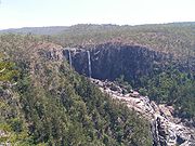 Wallaman Falls
on Stony Creek another tributary of the Herbert, are Australia's highest permanent waterfall. Other waterfalls on the river include Herbert River Falls, Blencoe Falls
and Millstream Falls
.
The river's upper region is used mainly for cattle grazing, while the lower Herbert River floodplain is given over to sugar cane production. The middle reaches of the catchment include National Parks
, State Forests
and sections of the Wet Tropics World Heritage Area
.
Parts of the river, especially the Herbert River Gorge stretch, are used for kayak
ing and white water rafting
.
, was filmed on the "Goshen" cattle station in the upper Herbert River region, near the Blencoe Falls and Herbert River Gorge.
Far North Queensland
Far North Queensland, or FNQ, is the northernmost part of the Australian state of Queensland. The region, which contains a large section of the Tropical North Queensland area, stretches from the city of Cairns north to the Torres Strait...
Queensland
Queensland
Queensland is a state of Australia, occupying the north-eastern section of the mainland continent. It is bordered by the Northern Territory, South Australia and New South Wales to the west, south-west and south respectively. To the east, Queensland is bordered by the Coral Sea and Pacific Ocean...
, Australia
Australia
Australia , officially the Commonwealth of Australia, is a country in the Southern Hemisphere comprising the mainland of the Australian continent, the island of Tasmania, and numerous smaller islands in the Indian and Pacific Oceans. It is the world's sixth-largest country by total area...
. The southernmost of Queensland's wet tropics river systems, it is named after Robert George Wyndham Herbert
Robert Herbert
Sir Robert George Wyndham Herbert, GCB , was the first Premier of Queensland, Australia.-Early years:Born in Brighton, England, Herbert was the only son of the Hon. Algernon Herbert, a younger son of the first Earl of Carnarvon. He was educated at Eton and Balliol College, Oxford...
(1831–1905), the first Premier of Queensland
Premiers of Queensland
Before the 1890s, there was no developed party system in Queensland. Political affiliation labels before that time indicate a general tendency only. Before the end of the first decade of the twentieth century, political parties were more akin to parliamentary factions, and were fluid, informal and...
. William Landsborough was the first European explorer to trace the river's source.
Geography
It rises at an elevation of 1070 metres on the Atherton TablelandAtherton Tableland
The Atherton Tableland is a fertile plateau which is part of the Great Dividing Range in Queensland, Australia. It is located west to south-south-west inland from Cairns, well into the tropics, but its elevated position provides a climate suitable for dairy farming. It has an area of around...
, part of the Great Dividing Range
Great Dividing Range
The Great Dividing Range, or the Eastern Highlands, is Australia's most substantial mountain range and the third longest in the world. The range stretches more than 3,500 km from Dauan Island off the northeastern tip of Queensland, running the entire length of the eastern coastline through...
, west of Herberton
Herberton, Queensland
Herberton is a town on the Atherton Tableland in Far North Queensland, Australia. At the 2006 census, Herberton had a population of 974.-History:...
and north of Ravenshoe
Ravenshoe, Queensland
Ravenshoe is a town on the Atherton Tableland in Far North Queensland, Australia. It is located south west of the regional centre, Cairns. At the 2006 census, Ravenshoe had a population of 910....
. Its two head streams are the Millstream
Millstream
Millstream may refer to:*Millstream, a headstream of the Herbert River in Australia.*Millstream Falls*The Millstream, a fictional stream in the World of Greyhawk campaign setting for the Dungeons & Dragons role-playing game....
and Wild River. Flowing for 340 kilometres in a generally southeastern direction, it passes the town of Ingham
Ingham, Queensland
Ingham is a town in the Great Green Way region of North Queensland, Australia. The town was founded in 1864, gazetted a shire in 1879, and is the service centre for many sugarcane plantations, pioneered in the 1870s by William Ingham, for whom the town is named...
before entering the Coral Sea
Coral Sea
The Coral Sea is a marginal sea off the northeast coast of Australia. It is bounded in the west by the east coast of Queensland, thereby including the Great Barrier Reef, in the east by Vanuatu and by New Caledonia, and in the north approximately by the southern extremity of the Solomon Islands...
near Lucinda
Lucinda, Queensland
Lucinda is a coastal town in the state of Queensland, Australia, located at the southern entrance to Hinchinbrook Channel near the town of Ingham. A sugar-exporting town, Lucinda is noted for its 6km-long sugar jetty, the world's largest bulk sugar loading facility...
, at the southern end of the Hinchinbrook Channel
Hinchinbrook Channel
The Hinchinbrook Channel is a channel between the Australian mainland and Hinchinbrook Island. It runs between Oyster Point, just south of Cardwell, and Lucinda in Far North Queensland. The Aboriginal name for the channel is Bolan Milbirmi. The Herbert River flows into the channel's southern...
, 130 km north of Townsville. Heavy rainfall causes the river level and speed of flow to rise very quickly, especially in the lower flood plain areas around Ingham.
Its tributaries include Blunder, Sunday and Cameron Creeks, which all rise in the Cardwell Range and drain the northern portion of the river's catchment area
Drainage basin
A drainage basin is an extent or an area of land where surface water from rain and melting snow or ice converges to a single point, usually the exit of the basin, where the waters join another waterbody, such as a river, lake, reservoir, estuary, wetland, sea, or ocean...
, upstream of the Herbert River Falls
Herbert River Falls
Herbert River Falls are on the Herbert River on the northern boundary of the Girringun National Park, west of Cardwell, in Queensland, Australia....
. Further south the catchment is drained by Nanyeta (Return) and Rudd Creeks, which flow out of the Great Dividing Range
Great Dividing Range
The Great Dividing Range, or the Eastern Highlands, is Australia's most substantial mountain range and the third longest in the world. The range stretches more than 3,500 km from Dauan Island off the northeastern tip of Queensland, running the entire length of the eastern coastline through...
west of Mount Garnet and from the Forty Mile Scrub area. In total, the river has a catchment of 10130 km².
Wallaman Falls
The Wallaman Falls are notable for their single-drop of 268 metres, which is Australia's highest permanent waterfall. The pool at the end of the waterfall is 20 metres deep....
on Stony Creek another tributary of the Herbert, are Australia's highest permanent waterfall. Other waterfalls on the river include Herbert River Falls, Blencoe Falls
Blencoe Falls
Blencoe Falls are located on Blencoe Creek, a tributary of the Herbert River, 2 km north of a confluence, within the Girringun National Park in Queensland, Australia...
and Millstream Falls
Millstream Falls
Millstream Falls is found on a tributary to the Herbert River known as The Millstream, 15 km southwest of Ravenshoe, on the Atherton Tableland in Far North Queensland, Australia. Protected within the Millstream Falls National Park, the falls are accessible by road from the Kennedy...
.
People and land use
The catchment area holds a population of about 18,000, 75% of whom dwell in the lower flood plain area.The river's upper region is used mainly for cattle grazing, while the lower Herbert River floodplain is given over to sugar cane production. The middle reaches of the catchment include National Parks
Protected areas of Queensland
Queensland is the second largest state in Australia. It contains 470 separate Protected Areas with a total land area of 69,388 km² . 223 of these are National parks, which is the highest number of any Australian state or territory, totalling 65,871 km²...
, State Forests
State forest
A state forest is a forest that is administered or protected by some agency of a sovereign state.The precise application of the term varies by jurisdiction...
and sections of the Wet Tropics World Heritage Area
Wet Tropics of Queensland
The Wet Tropics of Queensland World Heritage Site consists of approximately 8,940 km² of Australian wet tropical forests growing along the north-east Queensland portion of the Great Dividing Range, stretching from Townsville to Cooktown, running in close parallel to the Great Barrier Reef...
.
Parts of the river, especially the Herbert River Gorge stretch, are used for kayak
Kayak
A kayak is a small, relatively narrow, human-powered boat primarily designed to be manually propelled by means of a double blade paddle.The traditional kayak has a covered deck and one or more cockpits, each seating one paddler...
ing and white water rafting
Rafting
Rafting or white water rafting is a challenging recreational outdoor activity using an inflatable raft to navigate a river or other bodies of water. This is usually done on white water or different degrees of rough water, in order to thrill and excite the raft passengers. The development of this...
.
Recent history
The second series of American reality television series, SurvivorSurvivor: The Australian Outback
Survivor: The Australian Outback is the second season of the United States reality show Survivor. Filming took place at Goshen Station in northern Queensland during 2000 and aired from January 28, 2001 to May 3, 2001 on CBS...
, was filmed on the "Goshen" cattle station in the upper Herbert River region, near the Blencoe Falls and Herbert River Gorge.
2010–2011 Queensland floods
The river has been one of the rivers involved in the 2010–2011 Queensland floods2010–2011 Queensland floods
A series of floods hit Australia, beginning in December 2010, primarily in the state of Queensland including its capital city, Brisbane. The floods forced the evacuation of thousands of people from towns and cities. At least seventy towns and over 200,000 people were affected. Damage initially was...