
Hatley, Cambridgeshire
Encyclopedia
Hatley is a civil parish in South
Cambridgeshire
, England
. It lies between the villages of Gamlingay
and Croydon
, 12 miles south-west of the city of Cambridge
and eight miles south-east of the town of St Neots
. In 2001, the population of Hatley parish was 205 people living in 77 households.
. The parishes were known as 'Hungry Hatley' by 1218, possibly because the clay soil could not be cultivated effectively until mechanisation in the 20th century. The adjoining parish of Cockayne Hatley
, in Bedfordshire
, is said to be unconnected to the Cambridgeshire Hatleys.
In 1831, the population of the parish of Hatley St George was 105 people. At the time of the census in 1921, it was 67 people.
by one councillor for the Gamlingay electoral division. It is in the parliamentary constituency of South Cambridgeshire, represented at the House of Commons by Andrew Lansley
.
and 45 miles north of London
. The elevation ranges between 55 and 79 metres (180-260 feet) above sea level. The soil is clay subsoil with boulder clay
. The parish covers an area of 958 hectares.
Around half of the land in Hatley parish belongs to the Hatley Park Estate. 76% of land is used for crops or fallow land; 9.5% is covered by grass, 4.9% by woodland and 7.1% by set-aside
. Wheat
, barley
and rapeseed
are grown. In summer, the estate's parkland is grazed by beef cattle and by sheep in winter. The yard at Church Farm, owned by the estate, has been converted to small business units. One other farm is in the parish and two neighbouring farmers use land in it.
There are two main settlements in the parish, connected by a minor road. Hatley St George consists of a row of houses along the Gamlingay-Croydon road. It has a small shop and post office, (subsidised by the estate) a playing field, playground and cricket
club. It is presumed that the hamlet's name is derived from that of the St George family, who were the principal landowners from the 13th century to 1658. Hatley St George is an 'estate village' - Hatley Park Estate owns all the houses except for five. About a third are used for current and retired estate workers, with the others rented out.
 East Hatley is a row of houses along a smaller road. It was formerly known as Castell Hatley. In 1929, the hamlet was owned by the Master and Fellows of Downing College, Cambridge
. Sir George Downing, 1st Baronet
, after whom Downing Street
is named, owned land in East Hatley (his grandson, Sir George Downing, 3rd Baronet
, founded Downing College).
Historically, East Hatley housed local farm labourers. Now, few agricultural workers live there and it has been described as a 'small, middle-class commuter settlement'. The houses are mainly privately owned but there are three council-owned bungalows. There is little interaction between East Hatley and Hatley St George.
Hatley village hall was built by the estate in 1960. It was run as a social club before it became financially unviable, closing in 2005, and is now run by the Parish Council.
Around one-third of the parish is occupied by Hatley Park, an area of private landscaped parkland south of the road, formerly owned by Sir John Astor MBE
.
, the population of Hatley parish was 205 people living in 77 households. The ethnic group of 98.6% of Hatley residents was white and 1.4% Asian or Asian British. 73.7% described themselves as Christian
.
Hatley has a high rate of in-migration and commuting, and retains economically strong farming activities. Hatley Park once employed most Hatley St George residents. There was formerly a Thoroughbred
stud farm
in Hatley Park, employing 15 people, but it is now a livery yard staffed by two for most of the year. Seven Hatley St George residents were employed on the estate in 2007; a number of people work for the Royal Society for the Protection of Birds
, whose headquarters
is nearby at Sandy, Bedfordshire
. At the time of the 2001 census, 17.7% of Hatley residents were self-employed, 2.1% were unemployed and 4% were employed in agriculture.
 In addition to the two churches, two buildings in Hatley parish are listed: Hatley Park Lodge and model farm
buildings at Church Farm, Hatley St George.
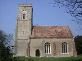
Hatley St George has a church, dedicated to St George, which was first built in 1352. It is a Grade II* listed building. Services take place every two weeks. East Hatley's church, dedicated to St Denis
, has been disused since 1980. It is also a Grade II* listed building. Hatley's churches are part of the ecclesiastical parish
of Gamlingay with Hatley St George and East Hatley, in the diocese of Ely
.
There are remnants of ancient woodland: Buff Wood
, south-west of East Hatley, is a Site of Special Scientific Interest
(SSSI) owned by the estate and managed by the local Wildlife Trust
, and Hayley Wood
, another SSSI, borders the parish in the north.
South Cambridgeshire
South Cambridgeshire is a mostly rural local government district of Cambridgeshire, England. It was formed on 1 April 1974 by the merger of Chesterton Rural District and South Cambridgeshire Rural District. It surrounds the city of Cambridge, which is administered separately from the district by...
Cambridgeshire
Cambridgeshire
Cambridgeshire is a county in England, bordering Lincolnshire to the north, Norfolk to the northeast, Suffolk to the east, Essex and Hertfordshire to the south, and Bedfordshire and Northamptonshire to the west...
, England
England
England is a country that is part of the United Kingdom. It shares land borders with Scotland to the north and Wales to the west; the Irish Sea is to the north west, the Celtic Sea to the south west, with the North Sea to the east and the English Channel to the south separating it from continental...
. It lies between the villages of Gamlingay
Gamlingay
Gamlingay is a village and civil parish in South Cambridgeshire, England, near the border with Bedfordshire, and the traditional county of Huntingdonshire...
and Croydon
Croydon, Cambridgeshire
Croydon is a village and civil parish in South Cambridgeshire, England. It is south-west of Cambridge and immediately west of the A1198 road . The population in 2001 was 221 people...
, 12 miles south-west of the city of Cambridge
Cambridge
The city of Cambridge is a university town and the administrative centre of the county of Cambridgeshire, England. It lies in East Anglia about north of London. Cambridge is at the heart of the high-technology centre known as Silicon Fen – a play on Silicon Valley and the fens surrounding the...
and eight miles south-east of the town of St Neots
St Neots
St Neots is a town and civil parish with a population of 26,356 people. It lies on the River Great Ouse in Huntingdonshire District, approximately north of central London, and is the largest town in Cambridgeshire . The town is named after the Cornish monk St...
. In 2001, the population of Hatley parish was 205 people living in 77 households.
History
The Hatley name was in use as early as 986, derived from 'laie' or 'ley', a woodland clearing, or 'woodland clearing on the hill'. The spelling Hatelaie was used in the 1086 Domesday BookDomesday Book
Domesday Book , now held at The National Archives, Kew, Richmond upon Thames in South West London, is the record of the great survey of much of England and parts of Wales completed in 1086...
. The parishes were known as 'Hungry Hatley' by 1218, possibly because the clay soil could not be cultivated effectively until mechanisation in the 20th century. The adjoining parish of Cockayne Hatley
Cockayne Hatley
Cockayne Hatley is a small village in Bedfordshire dating back to Saxon times , bordering on Cambridgeshire, 3 miles east of Potton, 6 miles north-east from Biggleswade and 9 miles south-east from St. Neots. The village's population in 1891 was 104.The soil is strong clay with clay subsoil...
, in Bedfordshire
Bedfordshire
Bedfordshire is a ceremonial county of historic origin in England that forms part of the East of England region.It borders Cambridgeshire to the north-east, Northamptonshire to the north, Buckinghamshire to the west and Hertfordshire to the south-east....
, is said to be unconnected to the Cambridgeshire Hatleys.
In 1831, the population of the parish of Hatley St George was 105 people. At the time of the census in 1921, it was 67 people.
Governance
The parish was established in 1957 when the parish of Hatley St George was united with East Hatley. Hatley Parish Council comprises three members, a chairman, vice-chairman and a clerk. The parish is represented on the South Cambridgeshire District Council by two councillors for the Gamlingay ward and on Cambridgeshire County CouncilCambridgeshire County Council
Cambridgeshire County Council is the county council of Cambridgeshire, England. The council currently consists of 69 councillors, representing 60 electoral divisions. The Conservative Party has a majority on the council, having gained control in the 1997 local elections...
by one councillor for the Gamlingay electoral division. It is in the parliamentary constituency of South Cambridgeshire, represented at the House of Commons by Andrew Lansley
Andrew Lansley
Andrew David Lansley, CBE, MP is the UK Secretary of State for Health, who has been the Conservative Member of Parliament for South Cambridgeshire since the 1997 general election, and was Shadow Secretary of State for Health from June 2004 until becoming Secretary of State for Health in May 2010...
.
Geography
Hatley is 12 miles south-west of the county town of CambridgeCambridge
The city of Cambridge is a university town and the administrative centre of the county of Cambridgeshire, England. It lies in East Anglia about north of London. Cambridge is at the heart of the high-technology centre known as Silicon Fen – a play on Silicon Valley and the fens surrounding the...
and 45 miles north of London
London
London is the capital city of :England and the :United Kingdom, the largest metropolitan area in the United Kingdom, and the largest urban zone in the European Union by most measures. Located on the River Thames, London has been a major settlement for two millennia, its history going back to its...
. The elevation ranges between 55 and 79 metres (180-260 feet) above sea level. The soil is clay subsoil with boulder clay
Boulder clay
Boulder clay, in geology, is a deposit of clay, often full of boulders, which is formed in and beneath glaciers and ice-sheets wherever they are found, but is in a special sense the typical deposit of the Glacial Period in northern Europe and North America...
. The parish covers an area of 958 hectares.
Around half of the land in Hatley parish belongs to the Hatley Park Estate. 76% of land is used for crops or fallow land; 9.5% is covered by grass, 4.9% by woodland and 7.1% by set-aside
Set-aside
Set-aside was introduced as a political measure by the European Union in 1988 to help reduce the large and costly surpluses produced in Europe under the guaranteed price system of the Common Agricultural Policy ; and to deliver some environmental benefits following considerable damage to...
. Wheat
Wheat
Wheat is a cereal grain, originally from the Levant region of the Near East, but now cultivated worldwide. In 2007 world production of wheat was 607 million tons, making it the third most-produced cereal after maize and rice...
, barley
Barley
Barley is a major cereal grain, a member of the grass family. It serves as a major animal fodder, as a base malt for beer and certain distilled beverages, and as a component of various health foods...
and rapeseed
Rapeseed
Rapeseed , also known as rape, oilseed rape, rapa, rappi, rapaseed is a bright yellow flowering member of the family Brassicaceae...
are grown. In summer, the estate's parkland is grazed by beef cattle and by sheep in winter. The yard at Church Farm, owned by the estate, has been converted to small business units. One other farm is in the parish and two neighbouring farmers use land in it.
There are two main settlements in the parish, connected by a minor road. Hatley St George consists of a row of houses along the Gamlingay-Croydon road. It has a small shop and post office, (subsidised by the estate) a playing field, playground and cricket
Cricket
Cricket is a bat-and-ball game played between two teams of 11 players on an oval-shaped field, at the centre of which is a rectangular 22-yard long pitch. One team bats, trying to score as many runs as possible while the other team bowls and fields, trying to dismiss the batsmen and thus limit the...
club. It is presumed that the hamlet's name is derived from that of the St George family, who were the principal landowners from the 13th century to 1658. Hatley St George is an 'estate village' - Hatley Park Estate owns all the houses except for five. About a third are used for current and retired estate workers, with the others rented out.
Cambridge
The city of Cambridge is a university town and the administrative centre of the county of Cambridgeshire, England. It lies in East Anglia about north of London. Cambridge is at the heart of the high-technology centre known as Silicon Fen – a play on Silicon Valley and the fens surrounding the...
. Sir George Downing, 1st Baronet
Sir George Downing, 1st Baronet
Sir George Downing, 1st Baronet was an Anglo-Irish soldier, statesman, and diplomat. Downing Street in London is named after him. As Treasury Secretary he is credited with instituting major reforms in public finance. His influence was substantial on the passage and substance of the mercantilist...
, after whom Downing Street
Downing Street
Downing Street in London, England has for over two hundred years housed the official residences of two of the most senior British cabinet ministers: the First Lord of the Treasury, an office now synonymous with that of Prime Minister of the United Kingdom, and the Second Lord of the Treasury, an...
is named, owned land in East Hatley (his grandson, Sir George Downing, 3rd Baronet
Sir George Downing, 3rd Baronet
Sir George Downing, 3rd Baronet, KB was a politician and, through a donation in his will, the founder of Downing College, Cambridge.Gordon Goodwin, ‘Downing, Sir George, third baronet ’, rev...
, founded Downing College).
Historically, East Hatley housed local farm labourers. Now, few agricultural workers live there and it has been described as a 'small, middle-class commuter settlement'. The houses are mainly privately owned but there are three council-owned bungalows. There is little interaction between East Hatley and Hatley St George.
Hatley village hall was built by the estate in 1960. It was run as a social club before it became financially unviable, closing in 2005, and is now run by the Parish Council.
Around one-third of the parish is occupied by Hatley Park, an area of private landscaped parkland south of the road, formerly owned by Sir John Astor MBE
Jakie Astor
Sir John Jacob "Jakie" Astor MBE was a British politician and sportsman and a member of the prominent Astor family....
.
Demography
At the time of the 2001 censusUnited Kingdom Census 2001
A nationwide census, known as Census 2001, was conducted in the United Kingdom on Sunday, 29 April 2001. This was the 20th UK Census and recorded a resident population of 58,789,194....
, the population of Hatley parish was 205 people living in 77 households. The ethnic group of 98.6% of Hatley residents was white and 1.4% Asian or Asian British. 73.7% described themselves as Christian
Christian
A Christian is a person who adheres to Christianity, an Abrahamic, monotheistic religion based on the life and teachings of Jesus of Nazareth as recorded in the Canonical gospels and the letters of the New Testament...
.
Hatley has a high rate of in-migration and commuting, and retains economically strong farming activities. Hatley Park once employed most Hatley St George residents. There was formerly a Thoroughbred
Thoroughbred
The Thoroughbred is a horse breed best known for its use in horse racing. Although the word thoroughbred is sometimes used to refer to any breed of purebred horse, it technically refers only to the Thoroughbred breed...
stud farm
Stud farm
A stud farm or stud in animal husbandry, is an establishment for selective breeding of livestock. The word "stud" comes from the Old English stod meaning "herd of horses, place where horses are kept for breeding" Historically, documentation of the breedings that occur on a stud farm leads to the...
in Hatley Park, employing 15 people, but it is now a livery yard staffed by two for most of the year. Seven Hatley St George residents were employed on the estate in 2007; a number of people work for the Royal Society for the Protection of Birds
Royal Society for the Protection of Birds
Bird Notes and News was first published in April 1903.The title changed to 'Bird Notes' in 1947. In the 1950s, there were four copies per year . Each volume covered two years, spread over three calendar years...
, whose headquarters
RSPB The Lodge
RSPB The Lodge is a nature reserve run by the RSPB, named after the building there, The Lodge, which is their headquarters. It is located south-east of the town of Sandy, Bedfordshire, in England.- Reserve :...
is nearby at Sandy, Bedfordshire
Sandy, Bedfordshire
Sandy is a small market town and civil parish in Bedfordshire, England. It is between Cambridge and Bedford, and on the A1 road from London to Edinburgh. The area is dominated by a range of hills known as the Sand Hills. The River Ivel runs through Sandy. The dedication of the Anglican church is to...
. At the time of the 2001 census, 17.7% of Hatley residents were self-employed, 2.1% were unemployed and 4% were employed in agriculture.
Landmarks
Model Farm
A model farm was an 18th–19th century experimental farm, which researched and demonstrated improvements in agricultural techniques, efficiency, and building layout. Education and commitment to improving welfare standards of workers were also aspects of the ideal farm movement...
buildings at Church Farm, Hatley St George.
Hatley St George has a church, dedicated to St George, which was first built in 1352. It is a Grade II* listed building. Services take place every two weeks. East Hatley's church, dedicated to St Denis
Denis
Saint Denis is a Christian martyr and saint. In the third century, he was Bishop of Paris. He was martyred in connection with the Decian persecution of Christians, shortly after A.D. 250...
, has been disused since 1980. It is also a Grade II* listed building. Hatley's churches are part of the ecclesiastical parish
Parish
A parish is a territorial unit historically under the pastoral care and clerical jurisdiction of one parish priest, who might be assisted in his pastoral duties by a curate or curates - also priests but not the parish priest - from a more or less central parish church with its associated organization...
of Gamlingay with Hatley St George and East Hatley, in the diocese of Ely
Diocese of Ely
The Diocese of Ely is a Church of England diocese in the Province of Canterbury. It is headed by the Bishop of Ely, who sits at Ely Cathedral in Ely. There is one suffragan bishop, the Bishop of Huntingdon. The diocese now covers Cambridgeshire and western Norfolk...
.
There are remnants of ancient woodland: Buff Wood
Buff Wood
Buff Wood has a core of ancient woodland, with surrounding areas of secondary woodland planted from the middle ages onward. The wood is 15.6 ha in area, managed by the Wildlife Trust for Bedfordshire, Cambridgeshire, Northamptonshire and Peterborough. It is located south of the village of...
, south-west of East Hatley, is a Site of Special Scientific Interest
Site of Special Scientific Interest
A Site of Special Scientific Interest is a conservation designation denoting a protected area in the United Kingdom. SSSIs are the basic building block of site-based nature conservation legislation and most other legal nature/geological conservation designations in Great Britain are based upon...
(SSSI) owned by the estate and managed by the local Wildlife Trust
Wildlife Trust for Bedfordshire, Cambridgeshire, Northamptonshire and Peterborough
The Wildlife Trust for Bedfordshire, Cambridgeshire, Northamptonshire and Peterborough is a wildlife trust covering the counties of Bedfordshire, Cambridgeshire, Northamptonshire and the City of Peterborough in England....
, and Hayley Wood
Hayley Wood
Hayley Wood, in Cambridgeshire, is managed as a nature reserve by the Wildlife Trust for Bedfordshire, Cambridgeshire, Northamptonshire and Peterborough...
, another SSSI, borders the parish in the north.