
Hardraw Force
Encyclopedia
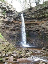
Hardraw Force is a waterfall
on the Hardraw Beck in Hardraw Scar, a wooded ravine
just outside the hamlet
of Hardraw
at the foot of Buttertubs Pass
and the head of Wensleydale
in the Yorkshire Dales
. The Pennine Way
long distance footpath passes close by.
Comprising a single drop of 100 feet from a rocky
overhang, Hardraw Force is claimed to be England's
highest unbroken waterfall – at least discounting underground
falls. (The underground waterfall inside nearby Gaping Gill
on the western flank of Ingleborough
has an unbroken fall of over 300 feet.)
Geologically, the bed of the river and plunge pool is slate; on top of that is sandstone and the top layer is carboniferous limestone.
Public viewing of Hardraw Force is rather unusual, as the visitor has to go through the bar of the Green Dragon Inn public house in Hardraw to reach the falls; an entrance fee is payable on the way through the pub. It is currently £2 per adult. Access behind the falls is now prohibited.
gorge located behind the Green Dragon inn at Hardraw near Hawes
in the Yorkshire Dales
. It is a natural amphitheatre and is the site of an annual brass band entertainment contest in September. The contest attracts bands from all over the North of England an is a popular event amongst players and audiences alike.
The gorge is situated alongside the Pennine Way
and also has an impressive waterfall, Hardraw Force, at the far end. Access to the gorge is via the nearby public house.
, in the scene where Maid Marian catches Robin Hood bathing under a waterfall.
Hardraw Force is the setting for a brass band competition held annually on the second Sunday in September. The competition was first held in the falls' natural amphitheatre in 1884 when six bands took part; the competition lapsed in 1927 but was revived in 1976 and has gone from strength to strength since. In recent years two other musical events have started up at the falls: the Hawdraw Bash is a Folk Rock concert in early July and the Hardraw Gathering is a three-day festival of traditional music at the end of July.
Waterfall
A waterfall is a place where flowing water rapidly drops in elevation as it flows over a steep region or a cliff.-Formation:Waterfalls are commonly formed when a river is young. At these times the channel is often narrow and deep. When the river courses over resistant bedrock, erosion happens...
on the Hardraw Beck in Hardraw Scar, a wooded ravine
Ravine
A ravine is a landform narrower than a canyon and is often the product of streamcutting erosion. Ravines are typically classified as larger in scale than gullies, although smaller than valleys. A ravine is generally a fluvial slope landform of relatively steep sides, on the order of twenty to...
just outside the hamlet
Hamlet (place)
A hamlet is usually a rural settlement which is too small to be considered a village, though sometimes the word is used for a different sort of community. Historically, when a hamlet became large enough to justify building a church, it was then classified as a village...
of Hardraw
Hardraw
Hardraw is a hamlet near Hawes within the Yorkshire Dales in North Yorkshire, England. It takes its name from the nearby Hardraw Force waterfall....
at the foot of Buttertubs Pass
Buttertubs Pass
The Buttertubs Pass is a high road in the Yorkshire Dales, England. The road winds its way north from Simonstone near Hawes towards Thwaite and Muker past 20 metre deep limestone potholes called the Buttertubs, It is said that the name of the potholes came from the times when farmers would rest...
and the head of Wensleydale
Wensleydale
Wensleydale is the valley of the River Ure on the east side of the Pennines in North Yorkshire, England.Wensleydale lies in the Yorkshire Dales National Park – one of only a few valleys in the Dales not currently named after its principal river , but the older name, "Yoredale", can still be seen...
in the Yorkshire Dales
Yorkshire Dales
The Yorkshire Dales is the name given to an upland area in Northern England.The area lies within the historic county boundaries of Yorkshire, though it spans the ceremonial counties of North Yorkshire, West Yorkshire and Cumbria...
. The Pennine Way
Pennine Way
The Pennine Way is a National Trail in England. The trail runs from Edale, in the northern Derbyshire Peak District, north through the Yorkshire Dales and the Northumberland National Park and ends at Kirk Yetholm, just inside the Scottish border. The path runs along the Pennine hills, sometimes...
long distance footpath passes close by.
Comprising a single drop of 100 feet from a rocky
Rock (geology)
In geology, rock or stone is a naturally occurring solid aggregate of minerals and/or mineraloids.The Earth's outer solid layer, the lithosphere, is made of rock. In general rocks are of three types, namely, igneous, sedimentary, and metamorphic...
overhang, Hardraw Force is claimed to be England's
England
England is a country that is part of the United Kingdom. It shares land borders with Scotland to the north and Wales to the west; the Irish Sea is to the north west, the Celtic Sea to the south west, with the North Sea to the east and the English Channel to the south separating it from continental...
highest unbroken waterfall – at least discounting underground
Karst topography
Karst topography is a geologic formation shaped by the dissolution of a layer or layers of soluble bedrock, usually carbonate rock such as limestone or dolomite, but has also been documented for weathering resistant rocks like quartzite given the right conditions.Due to subterranean drainage, there...
falls. (The underground waterfall inside nearby Gaping Gill
Gaping Gill
Gaping Gill is a natural cave in North Yorkshire, England. It is one of the unmistakable landmarks on the southern slopes of Ingleborough – a deep pothole with the stream Fell Beck flowing into it...
on the western flank of Ingleborough
Ingleborough
Ingleborough is the second highest mountain in the Yorkshire Dales. It is one of the Yorkshire Three Peaks, the other two being Whernside and Pen-y-ghent. Ingleborough is frequently climbed as part of the Yorkshire Three Peaks Challenge, which is a 24-mile circular challenge walk starting and...
has an unbroken fall of over 300 feet.)
Geologically, the bed of the river and plunge pool is slate; on top of that is sandstone and the top layer is carboniferous limestone.
Public viewing of Hardraw Force is rather unusual, as the visitor has to go through the bar of the Green Dragon Inn public house in Hardraw to reach the falls; an entrance fee is payable on the way through the pub. It is currently £2 per adult. Access behind the falls is now prohibited.
Hardraw Scar
Hardraw Scar (54.316°N 2.205°W) is a limestoneLimestone
Limestone is a sedimentary rock composed largely of the minerals calcite and aragonite, which are different crystal forms of calcium carbonate . Many limestones are composed from skeletal fragments of marine organisms such as coral or foraminifera....
gorge located behind the Green Dragon inn at Hardraw near Hawes
Hawes
Hawes is a small market town and civil parish in the Richmondshire district of North Yorkshire, England, being granted its market charter in 1699...
in the Yorkshire Dales
Yorkshire Dales
The Yorkshire Dales is the name given to an upland area in Northern England.The area lies within the historic county boundaries of Yorkshire, though it spans the ceremonial counties of North Yorkshire, West Yorkshire and Cumbria...
. It is a natural amphitheatre and is the site of an annual brass band entertainment contest in September. The contest attracts bands from all over the North of England an is a popular event amongst players and audiences alike.
The gorge is situated alongside the Pennine Way
Pennine Way
The Pennine Way is a National Trail in England. The trail runs from Edale, in the northern Derbyshire Peak District, north through the Yorkshire Dales and the Northumberland National Park and ends at Kirk Yetholm, just inside the Scottish border. The path runs along the Pennine hills, sometimes...
and also has an impressive waterfall, Hardraw Force, at the far end. Access to the gorge is via the nearby public house.
Hardraw Force and popular culture
The falls were used as a location in the film Robin Hood: Prince of ThievesRobin Hood: Prince of Thieves
Robin Hood: Prince of Thieves is a 1991 American adventure film directed by Kevin Reynolds. Kevin Costner heads the cast list as Robin Hood...
, in the scene where Maid Marian catches Robin Hood bathing under a waterfall.
Hardraw Force is the setting for a brass band competition held annually on the second Sunday in September. The competition was first held in the falls' natural amphitheatre in 1884 when six bands took part; the competition lapsed in 1927 but was revived in 1976 and has gone from strength to strength since. In recent years two other musical events have started up at the falls: the Hawdraw Bash is a Folk Rock concert in early July and the Hardraw Gathering is a three-day festival of traditional music at the end of July.
External links
- http://www.hardrawforce.com/
- http://www.mikes-walks.co.uk/Walks/Yorkshire_Dales/Selside/Hardraw_Force/hardraw_force.html