
Haldwani
Encyclopedia
Haldwani is a city, which along with its twin township of Kathgodam
forms the Haldwani-Kathgodam (हल्द्वानी-काठगोदाम) municipal board in Nainital District in the India
n state
of Uttarakhand
.
Haldwani is the third most populous city in Uttarakhand, and is known as the "Gateway of Kumaon
". In Kumaoni, the local dialect, the place is called "Halduvani", literally "forest (vana
) of Haldu", after the tree named "Haldu"http://dsal.uchicago.edu/reference/gazetteer/pager.html?objectid=DS405.1.I34_V13_016.gif, often referred to as "Kadamb" (Haldina cordifolia), which was found in abundance prior to deforestation for agriculture and settlement.
In 1816, after the British defeated Gorkhas, Gardner was appointed the Commissioner of Kumaon. Later George William Trail took over as Commissioner and renamed Halduvani as Haldwani in 1834. Though British records suggest that the place was established in 1834, as a mart for hill people who visited the Bhabhar
(Himalayan foothills) region, during the cold season.
 Mughal
historians mention that in 14th century, a local ruler, Gyan Chand of Chand Dynasty, visited Delhi Sultanate
and received the regions of Bhabhar
- Terai
up to the Ganges as a grant from then Sultan. Later, the Mughals tried to take over the hills, but their attempts received a setback due to the difficult terrain.
In 1856, Sir Henry Ramsay
took over as the Commissioner of Kumaon
. During the Indian Rebellion of 1857
, it was briefly seized by the rebels of Rohilkhand
, soon martial law was declared in the region by Sir Henry Ramsay, and by 1858, the region was cleared of the rebels.
Later, Ramsay connected Nainital with Kathgodam
by road in 1882. In 1883-84, the railway track was laid between Bareilly
and Kathgodam
. The first train arrived at Haldwani from Lucknow
on 24 April 1884. Later, the railway line was extended to Kathgodam.
In 1901, with a population of 6,624, Haldwani was the headquarters of the Bhabhar
region of Nainital District, in the United Province
, and it also used to become the winter headquarters of the officers of the Kumaun Division and of Nainital District. The Arya Samaj
Bhavan was built in 1901 and Sanatan Dharm Sabha in 1902. The Tehsil office was opened here in 1899, when it became the tehsil headquarters of the Bhabhar, one of four division of Nainital district, and included 4 towns and 511 villages; and had a combined population of 93,445 (1901), spread over 1,279 sq. miles. Though before the formation of Nainital district in 1891, it was part of the Kumaon District, which was later called Almora
district.
In 1904, it was consitituted as a 'notified area' and in 1907 Haldwani got the status of town area.
Gora Padao
, 4 km south of Haldwani was named after a British camp/post at that location in the mid-19th century, Gora being a slang for the British.
Haldwani-Kathgodam Municipal Council was established on 21 September 1942. Currently it is the third largest Municipal Council in the state of Uttarakhand after Haridwar
.
) where the mountain rivers go underground to re-emerge in the Indo-Gangetic plain
. It has historically been a trading post and then a hub between the hilly regions of Kumaon and the Indo-Gangetic Plain.
cremation ground. A fair called Uttarayani (also called Ghughutiya in Kumaoni) is held here on Makar Sankranti (on 13-14 of January) every year. To the south of Haldwani lies Pantnagar
famous for its Pantnagar University. The Gaula
river runs to the east, and to the west is the fertile agricultural region of Lamachaur and Kaladhungi merging into the world-renowned Corbett National Park.
Long in the shadow of its famous hill cousins, the Haldwani area has a lot to offer by the way of quaint villages, rolling deciduous forests and open spaces outside the urban sprawl.
Famous Personalities like G.B. Pant, Narayan Dutt Tewari etc. have been associated with Haldwani.
As of 2001 India census, [9] Haldwani-Kathgodam had a population of 497,869 . Males constitute 53% of the population and females 47%. Haldwani-Kathgodam has an average literacy rate of 69%, higher than the national average of 59.5% : male literacy is 73%, and female literacy is 65%. (The current population is between 5-6 lakhs). Change as per Censes.
Culture & lifestyle :
Haldwani (Nainital) today houses people of nearly all religions who have migrated and settled down in town in addition to the local Kumaonis and Garhwalis. This confluence of cultures is as evident in the architecture of the town as in the culture, occasions for celebration, attire and cuising.
Kuamoni and Hindi are the primary languages spoken in Haldwani. Urdu is prevalent amongst the muslim community while Punjabi is spoken by the large Sikh community settled in the town.
http://www.geohive.com/cntry/in-05.aspx
A small town till about 2 decades ago, rapid urbanization due to a number of factors has contributed to its rise as a regional hub trading in modern amenities and a better infrastructure (roads, shopping centres and hospitals).
Haldwani is said to be a "Great city shadowed by Nainital". Haldwani at all geo-political bases is always above Nainital town which is the District centre. The Govt. policy of "Polishing" Nainital and doing nothing for the ever big Haldwani city, has left the citizens of Haldwani demanding Haldwani as a new District headquarters in place of Nainital, or creating a new District called Haldwani consisting the Bhabhar area of Kumaon excluding the hilly Nainital. Many uprisings were led by the local public since independence with the demand for the creation of new District.
, ADVAYA classes ( a coaching classes for IIT-JEE/AIEEE/PMT)is the only institute in the city, which is fully run by IITians and producing IITians,NITians and good engineers every year to serve INDIA and World,FUTURE FORUM (Run by team of iitian & Ex. Faculties of KOTA)akash(for IIT-JEE/AIEEE/PMT) . D.A.V. Centenary Public School, The Heritage School which is one of the finest school in the town, Aryaman Vikram Birla, Dikshant International Pre-School, Aacharya Narendra Dev Vidyalaya (near Block Office), Hargovind Suyal Sharashwati Vidya Mandir Inter college, Govt. Inter College Banbhoolpura, Govt. Girls Inter College Haldwani, Mahatma Gandhi Inter College, H.N. Inter College, M.B. Inter College. Having One Degree College Moti Ram Babu Ram Govt. (Post Graduate) College. It has a premier university of agriculture and technology nearby namely Pantnagar University. It also has Sikkim Manipal University, Learning Center providing Management & IT Programs under the distance education mode address IT Campus, Tikonia Haldwani,ARENA ANIMATION(NAWABI ROAD), NIIT Education centre which has been providing careers in the global IT industry to the local students.
on 31 October 2005 with a view to democratize education, so that it covers large segments of population, vocations and professions. Uttarakhand Open University is the only Open University in Uttarakhand...
In the opening years of Uttarakhand Open University, corruption cases against the Principal and the mentor happened to arrive. This resulted in a gloomy future of the University.
Swami Rama Cancer Hospital and Research Institute is an affiliated institute which was envisioned to provide state-of-the-art treatment to cancer patients of Uttarakhand. Dr. Abhishek Singh, radiation and clinical oncologist at the institute feels need of efforts for cancer awareness in school children and general public of Kumaun region as well as Uttarakhand.
the Medical college is now undertaken by government in 2009.So its now GOVERNMENT SUSHILA TIWARI MEDICAL COLLEGE.
Its a college in uttarakhand which provides medical degree in only Rs.15000/-, but still most of the free seats are not taken up by local students, because of the fear that they would be sent to distant places in the country-side. This fear is being taken in consideration by the Govt. of the State and they are planning for some more benefits for medical students, so that both students and the public are treated equally..
, Dehradun
and Lucknow
) and rail (New Delhi
, Lucknow
and Agra
), Haldwani is an important commercial hub. It is home to one of the largest vegetable, fruit and foodgrain markets in Kumaon. Being the gateway to most of Kumaon
and parts of Garhwal
, it is an important revenue center of Uttarakhand
based on its advantageous location as a base depot for goods in transit to the hills. The Gaula river is exploited for a large quantity of boulders, sand and gravels every year, and forms an important revenue source for both the government and local business.
Aryaman Vikram Birla (Most famous school and number 2 due to array of facilities it provides)
List of some other schools which provide Higher Secondary education:-
1 . Nirmala convent
2 . Maharishi Vidya Mandir Public School
3 . Guru Tek Bahadur Public school
4 . Beersheba Sr. Sec. School
5 . St.Pauls Sr. Sec. School
6 . St. Theresa Sr. Sec. School
7 . Himalaya Sr sec school
8 . Queen Public school
9 . ABM Public sr.sec School
10 . Sacred Hearts Public School
11 . DAV Centenary Public School
12 . Mahatma Gandhi School
13 . M.B. inter college for boys
14 . GGIC and Khalsa college for girls
Some noted schools for small children are Parvatiya Shishu Niketan, Pratibha Vikas School and Tikku Modern.
Haldwani has many schools, and actually there are different educational houses which are providing education to the local children.
The nearest airport is Pantnagar airport with connecting flight of jackson airways to delhi.
The railway station is Haldwani railway station with four trains running per day to delhi.
The shortage of water in the Gaula river has forced the Administration to create some new projects for water harvesting and also increase of number of water treatment plants.
Haldwani is said to be a fast growing educational hub of Uttarakhand. Many new institutions are open in lower Haldwani areas. Since, the success of 108 Mobile medical van services across the province, the Govt. is planning to expand this service in a better way for the more populated Haldwani city. Haldwani's forests which bear the best timber (cite?) anywhere in India and South Asia, are for now in a motion of significant demand because of their best quality. So the Govt. is also planning to keep the forestry as green as it always was.
Kathgodam
Kathgodam is a town in the Nainital district of Uttarakhand state of India. It is part of the twin township of Haldwani-Kathgodam , and is immediately north of Haldwani.-History:...
forms the Haldwani-Kathgodam (हल्द्वानी-काठगोदाम) municipal board in Nainital District in the India
India
India , officially the Republic of India , is a country in South Asia. It is the seventh-largest country by geographical area, the second-most populous country with over 1.2 billion people, and the most populous democracy in the world...
n state
States and territories of India
India is a federal union of states comprising twenty-eight states and seven union territories. The states and territories are further subdivided into districts and so on.-List of states and territories:...
of Uttarakhand
Uttarakhand
Uttarakhand , formerly Uttaranchal, is a state in the northern part of India. It is often referred to as the Land of Gods due to the many holy Hindu temples and cities found throughout the state, some of which are among Hinduism's most spiritual and auspicious places of pilgrimage and worship...
.
Haldwani is the third most populous city in Uttarakhand, and is known as the "Gateway of Kumaon
Kumaon Division
For Kumaoni/Kumauni People see Kumauni PeopleKumaon or Kumaun is one of the two regions and administrative divisions of Uttarakhand, a mountainous state of northern India, the other being Garhwal. It includes the districts of Almora, Bageshwar, Champawat, Nainital, Pithoragarh, and Udham Singh Nagar...
". In Kumaoni, the local dialect, the place is called "Halduvani", literally "forest (vana
Vana
Vana can be:* The Hawaiian name for the Sea urchin * Vána — a fictional character from J R R Tolkien's legendarium* The Vanir — a family of gods in Norse mythology....
) of Haldu", after the tree named "Haldu"http://dsal.uchicago.edu/reference/gazetteer/pager.html?objectid=DS405.1.I34_V13_016.gif, often referred to as "Kadamb" (Haldina cordifolia), which was found in abundance prior to deforestation for agriculture and settlement.
In 1816, after the British defeated Gorkhas, Gardner was appointed the Commissioner of Kumaon. Later George William Trail took over as Commissioner and renamed Halduvani as Haldwani in 1834. Though British records suggest that the place was established in 1834, as a mart for hill people who visited the Bhabhar
Bhabhar
Bhabhar is the region south of the Lower Himalayas and the Siwalik Hills It is the alluvial apron of sediments washed down from the Siwaliks along the northern edge of the Indo-Gangetic Plain.-Etymology:...
(Himalayan foothills) region, during the cold season.
History
Mughal Empire
The Mughal Empire , or Mogul Empire in traditional English usage, was an imperial power from the Indian Subcontinent. The Mughal emperors were descendants of the Timurids...
historians mention that in 14th century, a local ruler, Gyan Chand of Chand Dynasty, visited Delhi Sultanate
Delhi Sultanate
The Delhi Sultanate is a term used to cover five short-lived, Delhi based kingdoms or sultanates, of Turkic origin in medieval India. The sultanates ruled from Delhi between 1206 and 1526, when the last was replaced by the Mughal dynasty...
and received the regions of Bhabhar
Bhabhar
Bhabhar is the region south of the Lower Himalayas and the Siwalik Hills It is the alluvial apron of sediments washed down from the Siwaliks along the northern edge of the Indo-Gangetic Plain.-Etymology:...
- Terai
Terai
The Terai is a belt of marshy grasslands, savannas, and forests located south of the outer foothills of the Himalaya, the Siwalik Hills, and north of the Indo-Gangetic Plain of the Ganges, Brahmaputra and their tributaries. The Terai belongs to the Terai-Duar savanna and grasslands ecoregion...
up to the Ganges as a grant from then Sultan. Later, the Mughals tried to take over the hills, but their attempts received a setback due to the difficult terrain.
In 1856, Sir Henry Ramsay
Henry Ramsay (Indian Army officer)
General Sir Henry Ramsay, KCSI, CB. was a general in the Indian Army, Commissioner of the Kumaon and Garwhal districts. He is regarded as one of the great soldier-administrators of British India....
took over as the Commissioner of Kumaon
Kumaon Division
For Kumaoni/Kumauni People see Kumauni PeopleKumaon or Kumaun is one of the two regions and administrative divisions of Uttarakhand, a mountainous state of northern India, the other being Garhwal. It includes the districts of Almora, Bageshwar, Champawat, Nainital, Pithoragarh, and Udham Singh Nagar...
. During the Indian Rebellion of 1857
Indian Rebellion of 1857
The Indian Rebellion of 1857 began as a mutiny of sepoys of the British East India Company's army on 10 May 1857, in the town of Meerut, and soon escalated into other mutinies and civilian rebellions largely in the upper Gangetic plain and central India, with the major hostilities confined to...
, it was briefly seized by the rebels of Rohilkhand
Rohilkhand
Rohilkhand is a region of northwestern Uttar Pradesh state of India.Rohilkhand lies on the upper Ganges alluvial plain and has an area of about 25,000 km²/10,000 square miles...
, soon martial law was declared in the region by Sir Henry Ramsay, and by 1858, the region was cleared of the rebels.
Later, Ramsay connected Nainital with Kathgodam
Kathgodam
Kathgodam is a town in the Nainital district of Uttarakhand state of India. It is part of the twin township of Haldwani-Kathgodam , and is immediately north of Haldwani.-History:...
by road in 1882. In 1883-84, the railway track was laid between Bareilly
Bareilly
Bareilly is a prominent city in Bareilly district in the northern Indian state of Uttar Pradesh. Standing on the Ramganga river, it is the capital of the Bareilly division and the geographical region Rohilkhand...
and Kathgodam
Kathgodam
Kathgodam is a town in the Nainital district of Uttarakhand state of India. It is part of the twin township of Haldwani-Kathgodam , and is immediately north of Haldwani.-History:...
. The first train arrived at Haldwani from Lucknow
Lucknow
Lucknow is the capital city of Uttar Pradesh in India. Lucknow is the administrative headquarters of Lucknow District and Lucknow Division....
on 24 April 1884. Later, the railway line was extended to Kathgodam.
In 1901, with a population of 6,624, Haldwani was the headquarters of the Bhabhar
Bhabhar
Bhabhar is the region south of the Lower Himalayas and the Siwalik Hills It is the alluvial apron of sediments washed down from the Siwaliks along the northern edge of the Indo-Gangetic Plain.-Etymology:...
region of Nainital District, in the United Province
United Provinces of Agra and Oudh
The United Provinces of Agra and Oudh was a province of India under the British Raj, which existed from 1902 to 1947; the official name was shortened by the Government of India Act 1935 to United Provinces, by which the province had been commonly known, and by which name it was also a province of...
, and it also used to become the winter headquarters of the officers of the Kumaun Division and of Nainital District. The Arya Samaj
Arya Samaj
Arya Samaj is a Hindu reform movement founded by Swami Dayananda on 10 April 1875. He was a sannyasi who believed in the infallible authority of the Vedas. Dayananda emphasized the ideals of brahmacharya...
Bhavan was built in 1901 and Sanatan Dharm Sabha in 1902. The Tehsil office was opened here in 1899, when it became the tehsil headquarters of the Bhabhar, one of four division of Nainital district, and included 4 towns and 511 villages; and had a combined population of 93,445 (1901), spread over 1,279 sq. miles. Though before the formation of Nainital district in 1891, it was part of the Kumaon District, which was later called Almora
Almora
Almora is a municipal board, a cantonment town in the Almora district in the state of Uttarakhand, India. Almora was founded in 1568.It is a town bustling with activity and a rich cultural heritage and history. It is considered the cultural heart of the Kumaon region of...
district.
In 1904, it was consitituted as a 'notified area' and in 1907 Haldwani got the status of town area.
Gora Padao
Gora Padao
Gora Padao , is an Indian village 4 km south of Haldwani is named after a British camp/post at that location in the mid-19th century. In 1856, Henry Ramsay took over as the Commissioner of Kumaon.The village population is about 5,000...
, 4 km south of Haldwani was named after a British camp/post at that location in the mid-19th century, Gora being a slang for the British.
Haldwani-Kathgodam Municipal Council was established on 21 September 1942. Currently it is the third largest Municipal Council in the state of Uttarakhand after Haridwar
Haridwar
Haridwar is an important pilgrimage city and municipality in the Haridwar district of Uttarakhand, India...
.
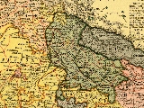
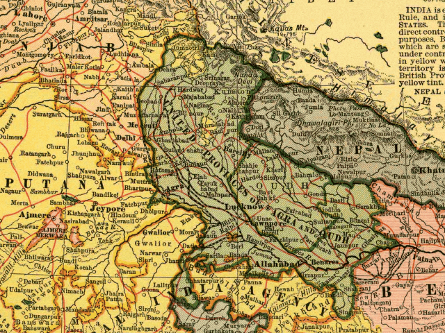
Geography
Haldwani is located at 29.22°N 79.52°E. It has an average elevation of 424 metres (1,391 feet). Geologically, Haldwani is settled on a piedmont grade (called BhabharBhabhar
Bhabhar is the region south of the Lower Himalayas and the Siwalik Hills It is the alluvial apron of sediments washed down from the Siwaliks along the northern edge of the Indo-Gangetic Plain.-Etymology:...
) where the mountain rivers go underground to re-emerge in the Indo-Gangetic plain
Indo-Gangetic plain
The northern Plains also known as the Indo - Gangetic Plain and The North Indian River Plain is a large and fertile plain encompassing most of northern and eastern India, the most populous parts of Pakistan, parts of southern Nepal and virtually all of Bangladesh...
. It has historically been a trading post and then a hub between the hilly regions of Kumaon and the Indo-Gangetic Plain.
Overview
Eight kilometres north of Haldwani at Ranibagh is Chitrashila Ghat, the venerable HinduHindu
Hindu refers to an identity associated with the philosophical, religious and cultural systems that are indigenous to the Indian subcontinent. As used in the Constitution of India, the word "Hindu" is also attributed to all persons professing any Indian religion...
cremation ground. A fair called Uttarayani (also called Ghughutiya in Kumaoni) is held here on Makar Sankranti (on 13-14 of January) every year. To the south of Haldwani lies Pantnagar
Pantnagar
Pantnagar is a town and a University campus in Udham Singh Nagar district, Uttarakhand. Nainital, Rudrapur and Kiccha, Haldwani are the major cities surrounding Pantnagar....
famous for its Pantnagar University. The Gaula
Gaula River (India)
The Gaula River is a river in India. It is approximately 500 kilometers long. It originates in the Sattal lakes of Uttarakhand state, and flows south past Kathgodam, Haldwani, and Shahi, finally joining the Ramganga River about northwest of Bareilly in Uttar Pradesh, Ramganga in turn is a...
river runs to the east, and to the west is the fertile agricultural region of Lamachaur and Kaladhungi merging into the world-renowned Corbett National Park.
Long in the shadow of its famous hill cousins, the Haldwani area has a lot to offer by the way of quaint villages, rolling deciduous forests and open spaces outside the urban sprawl.
Famous Personalities like G.B. Pant, Narayan Dutt Tewari etc. have been associated with Haldwani.
As of 2001 India census, [9] Haldwani-Kathgodam had a population of 497,869 . Males constitute 53% of the population and females 47%. Haldwani-Kathgodam has an average literacy rate of 69%, higher than the national average of 59.5% : male literacy is 73%, and female literacy is 65%. (The current population is between 5-6 lakhs). Change as per Censes.
Culture & lifestyle :
Haldwani (Nainital) today houses people of nearly all religions who have migrated and settled down in town in addition to the local Kumaonis and Garhwalis. This confluence of cultures is as evident in the architecture of the town as in the culture, occasions for celebration, attire and cuising.
Kuamoni and Hindi are the primary languages spoken in Haldwani. Urdu is prevalent amongst the muslim community while Punjabi is spoken by the large Sikh community settled in the town.
http://www.geohive.com/cntry/in-05.aspx
Culture, Sub culture & lifestyle
Since Haldwani is termed as the "Gateway of Kumaon" the region is dominated by Kumaoni people but still it is home to a significant percentage of people belonging to other religions and regions. One can find variety in all aspects from dishes to clothings and from dialect to architecture.Because of the dominance of Kumoani culture, Kumoani craftwork is usually visible in all aspects of Haldwani. Rock and popular English music is finding a good market in the rapidly expanding music market along with traditional Pahadi music of the state. Drinking is not considered a taboo anymore, given that the person doesn't drink in noon time, and is busy with his own job. Haldwani's people are usually very generous and also give good donations in all religious happening across the city. All types of National holidays are observed in the city with full joy.A small town till about 2 decades ago, rapid urbanization due to a number of factors has contributed to its rise as a regional hub trading in modern amenities and a better infrastructure (roads, shopping centres and hospitals).
Haldwani is said to be a "Great city shadowed by Nainital". Haldwani at all geo-political bases is always above Nainital town which is the District centre. The Govt. policy of "Polishing" Nainital and doing nothing for the ever big Haldwani city, has left the citizens of Haldwani demanding Haldwani as a new District headquarters in place of Nainital, or creating a new District called Haldwani consisting the Bhabhar area of Kumaon excluding the hilly Nainital. Many uprisings were led by the local public since independence with the demand for the creation of new District.
Education
Haldwani is home to the schools which provide an exceptionally high standard of pre-college education, without the elitism and expenses associated with the residential hill schools of Uttarakhand. The best schools of Haldwani are Aryaman vikram Birla institute Of Learning Nirmala Convent Sr. Sec. School and st theresa sr. sec school, few other local schools are A.B.M Senior Secondary School, Sri Guru Tegh Bahadur Senior Sec. School, Naini Valley School, Kendriya Vidhyalaya,beersheba senior secondary school, White Hall School, Unchapul. Maharishi Vidya Mandir, Queens Public school, , Birla Vidya mandir, St. Paul's Sr. Sec. School,Inspiration public school, Little flower school, Amrapali Institute - LamachaurAmrapali Institute - Lamachaur
Amrapali Institute is promoted by the Modern Academy Society, in Modinagar. Appreciating the difficulties faced by the youth of the area and also due to the paucity of suitable professional institutes, the Management decided to set up the Amrapali Institute at Haldwani, the gateway to the Kumaun...
, ADVAYA classes ( a coaching classes for IIT-JEE/AIEEE/PMT)is the only institute in the city, which is fully run by IITians and producing IITians,NITians and good engineers every year to serve INDIA and World,FUTURE FORUM (Run by team of iitian & Ex. Faculties of KOTA)akash(for IIT-JEE/AIEEE/PMT) . D.A.V. Centenary Public School, The Heritage School which is one of the finest school in the town, Aryaman Vikram Birla, Dikshant International Pre-School, Aacharya Narendra Dev Vidyalaya (near Block Office), Hargovind Suyal Sharashwati Vidya Mandir Inter college, Govt. Inter College Banbhoolpura, Govt. Girls Inter College Haldwani, Mahatma Gandhi Inter College, H.N. Inter College, M.B. Inter College. Having One Degree College Moti Ram Babu Ram Govt. (Post Graduate) College. It has a premier university of agriculture and technology nearby namely Pantnagar University. It also has Sikkim Manipal University, Learning Center providing Management & IT Programs under the distance education mode address IT Campus, Tikonia Haldwani,ARENA ANIMATION(NAWABI ROAD), NIIT Education centre which has been providing careers in the global IT industry to the local students.
Uttarakhand Open University
The University was established by an Act Of Uttarakhand Legislative AssemblyUttarakhand Legislative Assembly
The Uttarakhand Legislative Assembly also known as the Uttarakhand Vidhan Sabha, is a unicameral law making body of Uttarakhand, one of the 28 States in India, and is situated at Dehradun, the state capital of Uttarakhand, with 70 Members of the Legislative Assembly .The Chief Minister of...
on 31 October 2005 with a view to democratize education, so that it covers large segments of population, vocations and professions. Uttarakhand Open University is the only Open University in Uttarakhand...
In the opening years of Uttarakhand Open University, corruption cases against the Principal and the mentor happened to arrive. This resulted in a gloomy future of the University.
Govt. Shusila Tiwari Medical College
- A medical collegeMedical collegeA Medical College is a trade association that brings together practitioners of a particular geographical area . In common law countries often are grouped by medical specialties ....
(Sushila Tiwari Memorial(Uttarakhand Forest Hospital Trust ) Medical College), established by former CM N.D. Tiwari Ji.
Swami Rama Cancer Hospital and Research Institute is an affiliated institute which was envisioned to provide state-of-the-art treatment to cancer patients of Uttarakhand. Dr. Abhishek Singh, radiation and clinical oncologist at the institute feels need of efforts for cancer awareness in school children and general public of Kumaun region as well as Uttarakhand.
the Medical college is now undertaken by government in 2009.So its now GOVERNMENT SUSHILA TIWARI MEDICAL COLLEGE.
Its a college in uttarakhand which provides medical degree in only Rs.15000/-, but still most of the free seats are not taken up by local students, because of the fear that they would be sent to distant places in the country-side. This fear is being taken in consideration by the Govt. of the State and they are planning for some more benefits for medical students, so that both students and the public are treated equally..
Economy
Well connected with the Indo-Gangetic plain by road (to New DelhiNew Delhi
New Delhi is the capital city of India. It serves as the centre of the Government of India and the Government of the National Capital Territory of Delhi. New Delhi is situated within the metropolis of Delhi. It is one of the nine districts of Delhi Union Territory. The total area of the city is...
, Dehradun
Dehradun
- Geography :The Dehradun district has various types of physical geography from Himalayan mountains to Plains. Raiwala is the lowest point at 315 meters above sea level, and the highest points are within the Tiuni hills, rising to 3700 m above sea level...
and Lucknow
Lucknow
Lucknow is the capital city of Uttar Pradesh in India. Lucknow is the administrative headquarters of Lucknow District and Lucknow Division....
) and rail (New Delhi
New Delhi
New Delhi is the capital city of India. It serves as the centre of the Government of India and the Government of the National Capital Territory of Delhi. New Delhi is situated within the metropolis of Delhi. It is one of the nine districts of Delhi Union Territory. The total area of the city is...
, Lucknow
Lucknow
Lucknow is the capital city of Uttar Pradesh in India. Lucknow is the administrative headquarters of Lucknow District and Lucknow Division....
and Agra
Agra
Agra a.k.a. Akbarabad is a city on the banks of the river Yamuna in the northern state of Uttar Pradesh, India, west of state capital, Lucknow and south from national capital New Delhi. With a population of 1,686,976 , it is one of the most populous cities in Uttar Pradesh and the 19th most...
), Haldwani is an important commercial hub. It is home to one of the largest vegetable, fruit and foodgrain markets in Kumaon. Being the gateway to most of Kumaon
Kumaon Division
For Kumaoni/Kumauni People see Kumauni PeopleKumaon or Kumaun is one of the two regions and administrative divisions of Uttarakhand, a mountainous state of northern India, the other being Garhwal. It includes the districts of Almora, Bageshwar, Champawat, Nainital, Pithoragarh, and Udham Singh Nagar...
and parts of Garhwal
Garhwal Division
Garhwal is the north-western region and administrative division of the northern Indian state of Uttarakhand which is home to the Garhwali people. Lying in the Himalayas, It is bounded on the north by Tibet, on the east by Kumaon region, on the south by Uttar Pradesh state, and on the north-west by...
, it is an important revenue center of Uttarakhand
Uttarakhand
Uttarakhand , formerly Uttaranchal, is a state in the northern part of India. It is often referred to as the Land of Gods due to the many holy Hindu temples and cities found throughout the state, some of which are among Hinduism's most spiritual and auspicious places of pilgrimage and worship...
based on its advantageous location as a base depot for goods in transit to the hills. The Gaula river is exploited for a large quantity of boulders, sand and gravels every year, and forms an important revenue source for both the government and local business.
Hotels
- Hotel Happy Home, Bhawani Ganj, Nainital Road, Haldwani Ph: 05946- 251155 M: 7417412800
- Hotel Maharani,Nainital Road,Haldwani is a 3 star hotel.For more details and information please contact:05946-281550,281551. |
- Hotel Comfort Inn Saurabh Haldwani is a 3 star hotel. |
- Jaiguru Plaza, Nainital Road, Haldwani |
- Amrapali Hotel,Judge court Nainital road , Haldwani |
Cuisine
Some local delicacies are:- Bal MithaiBal MithaiBal Mithai is a brown chocolate-like fudge, made with roasted khoya, coated with white sugar balls, and is a popular sweet from the Himalayan state of Uttarakhand in India, especially regions around Almora...
("Chocolate" Mithai) - Bhatt ka joula
- Muli ka thechua
- Kakdi raee ka raita
- Gathi
- Gaderi ki sabzi
- Gauhat ki daal
- Lason ka lur
- Ras Bhat
- Jholi Bhat
- Bathue ka Paratha
- Madwe ki roti
- Bhatt ki churkani
- Bari bhat
- Bhang ki chatny
- Kaapa Bhaat
- Churkani
- Dhai ka Jaula
- Papad Ki Sabzi
- Peenalu Ki Sabzi
- Malta (fruit)
- Allu Gutuk
- Chanda Devi aur Saladi ka Raita
- Pinalu Gutuk
- Tinar
- Lai ka saag
- kafhal(fruit)
- khumani(fruit)
- pulam(fruit)
- bhutwa
Schools
Nirmala School (Number 1 school based on board results)Aryaman Vikram Birla (Most famous school and number 2 due to array of facilities it provides)
List of some other schools which provide Higher Secondary education:-
1 . Nirmala convent
2 . Maharishi Vidya Mandir Public School
3 . Guru Tek Bahadur Public school
4 . Beersheba Sr. Sec. School
5 . St.Pauls Sr. Sec. School
6 . St. Theresa Sr. Sec. School
7 . Himalaya Sr sec school
8 . Queen Public school
9 . ABM Public sr.sec School
10 . Sacred Hearts Public School
11 . DAV Centenary Public School
12 . Mahatma Gandhi School
13 . M.B. inter college for boys
14 . GGIC and Khalsa college for girls
Some noted schools for small children are Parvatiya Shishu Niketan, Pratibha Vikas School and Tikku Modern.
Haldwani has many schools, and actually there are different educational houses which are providing education to the local children.
Connectivity
Haldwani is well connected to the capital Delhi via road and air.The nearest airport is Pantnagar airport with connecting flight of jackson airways to delhi.
The railway station is Haldwani railway station with four trains running per day to delhi.
Future plans
There are various developmental plans for the city owing to its importance in the state of Uttarakhand. These include building of additional infrastructure like stadium, flyover, bus terminus and industrial complex. All this has come at a cost - the last 20 years have seen an explosion in the demographics leading to a creaking infrastructure. The city is struggling to live up to its sobriquet of "Green City".The shortage of water in the Gaula river has forced the Administration to create some new projects for water harvesting and also increase of number of water treatment plants.
Haldwani is said to be a fast growing educational hub of Uttarakhand. Many new institutions are open in lower Haldwani areas. Since, the success of 108 Mobile medical van services across the province, the Govt. is planning to expand this service in a better way for the more populated Haldwani city. Haldwani's forests which bear the best timber (cite?) anywhere in India and South Asia, are for now in a motion of significant demand because of their best quality. So the Govt. is also planning to keep the forestry as green as it always was.