
Hackney Brook
Encyclopedia
The Hackney Brook is one of the subterranean rivers of London
. It crossed the northern parts of the current London borough
s of Hackney
and Islington
, emptying into the River Lea at Hackney Wick
, with its source in Holloway
.
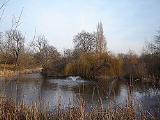
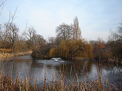 In Hackney, the river ran through the northern part of Clissold Park
, where its course is now marked by two lakes. It crossed the artificial New River
, which now flows at right angles to the brook and leaves the park to the south. The two Clissold park lakes are now fed from the main water supply, not the brook.
It then wandered through Abney Park Cemetery
to cross at the bottom of the road Stamford Hill to run along the north side of Stoke Newington Common
. At this point, builders found, in the 1860s, very early evidence of human occupation in the form of 200,000-year old palaeolithic flint
axes, which were being made on the banks of the brook. These are among the earliest human artefacts found in Britain.
From here, the brook followed the western side of Hackney Downs
, then ran south-east to cross Dalston Lane and Mare Street in Hackney Central
near Bohemia Place. Many 18th and 19th-century illustrations show the ford here, which was at the bend in the road where the North London Railway
bridge now crosses Mare Street. From here it ran through Homerton
and Hackney Wick to join the Lea.
In its heyday, up until the late 1830s, the brook was a substantial river, 10 metres wide in full flood at Stoke Newington and perhaps 30 metres wide at its junction with the Lea.
Its course can be seen on some old maps http://archivemaps.com/mapco/preview/index.htm.
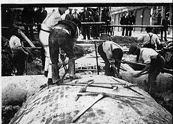 Although much of the Hackney Brook had already been covered over by 1856, local population growth in the area had turned the open portions into little more than an open sewer. In response to this, the Metropolitan Board of Works
constructed its northern high-level sewer in 1860 to a design by Sir Joseph Bazalgette
to contain the brook and its many tributaries. The sewer followed the course of the brook as far as Hackney Church Street (now Mare Street), but then struck south to cross Victoria Park
, joining the larger sewer network at Old Ford. Subsequent sewerage building has resulted in the Hackney Brook becoming quite untraceable, lost somewhere in the subterranean labyrinth of piping.
Subterranean rivers of London
The subterranean or underground rivers of London are the tributaries of the River Thames and River Lea that were built over during the growth of the metropolis of London...
. It crossed the northern parts of the current London borough
London borough
The administrative area of Greater London contains thirty-two London boroughs. Inner London comprises twelve of these boroughs plus the City of London. Outer London comprises the twenty remaining boroughs of Greater London.-Functions:...
s of Hackney
London Borough of Hackney
The London Borough of Hackney is a London borough of North/North East London, and forms part of inner London. The local authority is Hackney London Borough Council....
and Islington
London Borough of Islington
The London Borough of Islington is a London borough in Inner London. It was formed in 1965 by merging the former metropolitan boroughs of Islington and Finsbury. The borough contains two Westminster parliamentary constituencies, Islington North and Islington South & Finsbury...
, emptying into the River Lea at Hackney Wick
Hackney Wick
Hackney Wick is an area straddling the boundary between the London Borough of Hackney and the London Borough of Tower Hamlets in east London. It is an inner-city development situated 5 miles northeast of Charing Cross...
, with its source in Holloway
Holloway, London
Holloway is an inner-city district in the London Borough of Islington located north of Charing Cross and follows for the most part, the line of the Holloway Road . At the centre of Holloway is the Nag's Head area...
.
Course of the River
Clissold Park
Clissold Park is a community park in Stoke Newington within the London Borough of Hackney. Facilities include a children's playground, sports fields, a bowling green, tennis courts, a cafe and some animal attractions including terrapins in its lakes...
, where its course is now marked by two lakes. It crossed the artificial New River
New River (England)
The New River is an artificial waterway in England, opened in 1613 to supply London with fresh drinking water taken from the River Lea and from Amwell Springs , and other springs and wells along its course....
, which now flows at right angles to the brook and leaves the park to the south. The two Clissold park lakes are now fed from the main water supply, not the brook.
It then wandered through Abney Park Cemetery
Abney Park Cemetery
Abney Park in Stoke Newington, in the London Borough of Hackney, is a historic parkland originally laid out in the early 18th century by Lady Mary Abney and Dr. Isaac Watts, and the neighbouring Hartopp family. In 1840 it became a non-denominational garden cemetery, semi-public park arboretum, and...
to cross at the bottom of the road Stamford Hill to run along the north side of Stoke Newington Common
Stoke Newington Common
Stoke Newington Common is an open space in Stoke Newington in the London Borough of Hackney. It is east of Stoke Newington High Street, with Northwold Road to the north, and it straddles the busy Rectory Road....
. At this point, builders found, in the 1860s, very early evidence of human occupation in the form of 200,000-year old palaeolithic flint
Flint
Flint is a hard, sedimentary cryptocrystalline form of the mineral quartz, categorized as a variety of chert. It occurs chiefly as nodules and masses in sedimentary rocks, such as chalks and limestones. Inside the nodule, flint is usually dark grey, black, green, white, or brown in colour, and...
axes, which were being made on the banks of the brook. These are among the earliest human artefacts found in Britain.
From here, the brook followed the western side of Hackney Downs
Hackney Downs
Hackney Downs is an open space and a broader area in Lower Clapton, in the London Borough of Hackney; it is also the name of a local council ward. It borders on Stoke Newington to the west and Shacklewell to the south...
, then ran south-east to cross Dalston Lane and Mare Street in Hackney Central
Hackney Central
Hackney Central is the central district of the London Borough of Hackney in London, England. It comprises the area roughly surrounding, and extending north from Mare Street. It is situated north east of Charing Cross...
near Bohemia Place. Many 18th and 19th-century illustrations show the ford here, which was at the bend in the road where the North London Railway
North London Railway
The North London Railway was a railway company that opened lines connecting the north of London to the East and West India Docks. The main east to west route is now part the North London Line. Other lines operated by the company fell into disuse, but were later revived as part of the Docklands...
bridge now crosses Mare Street. From here it ran through Homerton
Homerton
Homerton is a place in the London Borough of Hackney. It is bordered to the west by Hackney Central, to the north by Lower Clapton, in the east by Hackney Wick, Leyton and by South Hackney to the south.-Origins:...
and Hackney Wick to join the Lea.
In its heyday, up until the late 1830s, the brook was a substantial river, 10 metres wide in full flood at Stoke Newington and perhaps 30 metres wide at its junction with the Lea.
Its course can be seen on some old maps http://archivemaps.com/mapco/preview/index.htm.
Disappearance
Metropolitan Board of Works
The Metropolitan Board of Works was the principal instrument of London-wide government from 1855 until the establishment of the London County Council in 1889. Its principal responsibility was to provide infrastructure to cope with London's rapid growth, which it successfully accomplished. The MBW...
constructed its northern high-level sewer in 1860 to a design by Sir Joseph Bazalgette
Joseph Bazalgette
Sir Joseph William Bazalgette, CB was an English civil engineer of the 19th century. As chief engineer of London's Metropolitan Board of Works his major achievement was the creation of a sewer network for central London which was instrumental in relieving the city from cholera epidemics, while...
to contain the brook and its many tributaries. The sewer followed the course of the brook as far as Hackney Church Street (now Mare Street), but then struck south to cross Victoria Park
Victoria Park, East London
Victoria Park is 86.18 hectares of open space that stretches out across part of the East End of London, England bordering parts of Bethnal Green, Hackney, and Bow, such as along Old Ford Road, London E3 and Victoria Park Road E9. The park is entirely within the London Borough of Tower Hamlets...
, joining the larger sewer network at Old Ford. Subsequent sewerage building has resulted in the Hackney Brook becoming quite untraceable, lost somewhere in the subterranean labyrinth of piping.