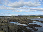
Green Point, Newfoundland and Labrador
Encyclopedia

Gros Morne National Park
Gros Morne National Park is a world heritage site located on the west coast of Newfoundland. At , it is the second largest national park in Atlantic Canada ....
, on the west coast of Newfoundland. It is the home to a small summer fishing community and a drive-in campground. In 2000, Green Point was designated the Global Stratotype Section and Point
Global Boundary Stratotype Section and Point
A Global Boundary Stratotype Section and Point, abbreviated GSSP, is an internationally agreed upon stratigraphic section which serves as the reference section for a particular boundary on the geologic time scale. The effort to define GSSPs is conducted by the International Commission on...
(GSSP) representing the division between the Cambrian
Cambrian
The Cambrian is the first geological period of the Paleozoic Era, lasting from Mya ; it is succeeded by the Ordovician. Its subdivisions, and indeed its base, are somewhat in flux. The period was established by Adam Sedgwick, who named it after Cambria, the Latin name for Wales, where Britain's...
and the Ordovician
Ordovician
The Ordovician is a geologic period and system, the second of six of the Paleozoic Era, and covers the time between 488.3±1.7 to 443.7±1.5 million years ago . It follows the Cambrian Period and is followed by the Silurian Period...
systems.
Geology
In 2000, the cliffs at Green Point were approved as the Global Stratotype Section and Point for the base of the Ordovician system by the International Union of Geological SciencesInternational Union of Geological Sciences
The International Union of Geological Sciences is an international non-governmental organization devoted to international cooperation in the field of geology.-About:...
. The boundary is a section 60m thick composed of layers of shale and limestone with overturned beds dipping 60-70 degrees to the South East. It is marked by the first appearance of Iapetognathus fluctivagus, a conodont
Conodont
Conodonts are extinct chordates resembling eels, classified in the class Conodonta. For many years, they were known only from tooth-like microfossils now called conodont elements, found in isolation. Knowledge about soft tissues remains relatively sparse to this day...
fossil, 4.8m below the earliest known planktic graptolite
Graptolite
Graptolithina is a class in the animal phylum Hemichordata, the members of which are known as Graptolites. Graptolites are fossil colonial animals known chiefly from the Upper Cambrian through the Lower Carboniferous...
fossil, Rhabdinopora praeparabola.
The shales
Shalës
Shalës is a municipality in the Elbasan District, Elbasan County, central Albania. The municipality consists of the villages Shalës, Licaj, Kurtalli, Xibrake, Xherie and Kodras....
represent a 30 million year record of deep-ocean sediments laid in a base-of-slope environment in the Iapetus Ocean
Iapetus Ocean
The Iapetus Ocean was an ocean that existed in the Neoproterozoic and Paleozoic eras of the geologic timescale . The Iapetus Ocean was situated in the southern hemisphere, between the paleocontinents of Laurentia, Baltica and Avalonia...
. The limestone
Limestone
Limestone is a sedimentary rock composed largely of the minerals calcite and aragonite, which are different crystal forms of calcium carbonate . Many limestones are composed from skeletal fragments of marine organisms such as coral or foraminifera....
layers indicate periodic avalanches from the shallower waters. Portions of the same limestone avalanches that came rest to further up the coastal slopes are featured at Cow Head. There, the individual rocks in the limestone conglomerate
Conglomerate (geology)
A conglomerate is a rock consisting of individual clasts within a finer-grained matrix that have become cemented together. Conglomerates are sedimentary rocks consisting of rounded fragments and are thus differentiated from breccias, which consist of angular clasts...
are much larger.
See also
Gros Morne National ParkGros Morne National Park
Gros Morne National Park is a world heritage site located on the west coast of Newfoundland. At , it is the second largest national park in Atlantic Canada ....
List of Global Boundary Stratotype Sections and Points

