

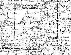
Gold Ridge, Georgia
Encyclopedia
Unincorporated area
In law, an unincorporated area is a region of land that is not a part of any municipality.To "incorporate" in this context means to form a municipal corporation, a city, town, or village with its own government. An unincorporated community is usually not subject to or taxed by a municipal government...
in Cherokee County
Cherokee County, Georgia
As of the census of 2000, there were 141,903 people, 49,495 households, and 39,200 families residing in the county. The population density was 335 people per square mile . There were 51,937 housing units at an average density of 123 per square mile...
, Georgia
Georgia (U.S. state)
Georgia is a state located in the southeastern United States. It was established in 1732, the last of the original Thirteen Colonies. The state is named after King George II of Great Britain. Georgia was the fourth state to ratify the United States Constitution, on January 2, 1788...
, United States
United States
The United States of America is a federal constitutional republic comprising fifty states and a federal district...
. It was settled in the middle 19th century and is located between Canton
Canton, Georgia
Canton is a city in and the county seat of Cherokee County, Georgia, United States. As of the 2010 census, the city had a population of 22,958.-Geography:Canton is located at ....
and the Sixes
Sixes, Georgia
Sixes is an unincorporated community in western Cherokee County, Georgia, United States, located about three miles west of Holly Springs and near the eastern shore of current-day Lake Allatoona. The community is located in the Georgia Gold Belt, which runs southwest to northeast along the southern...
community, which is home to the now-defunct Sixes Gold Mine
Sixes mine
The Sixes Mine is a group of former gold placer mines in the Georgia Gold Belt. They are near Sixes in Cherokee County, Georgia, United States, located off Bell's Ferry Road, south of Canton, Georgia. The mine's coordinates are .-History:...
. The area is located in the Georgia Gold Belt
Georgia Gold Belt
The largest quantities of gold found in the eastern United States were found in the Georgia Gold Belt, which extends from eastern Alabama to Rabun County, Georgia. The biggest concentration of gold was found in White, Lumpkin, and northern Cherokee counties in Georgia. The gold in the Georgia Gold...
, which runs southwest to northeast along the southern edge of the foothills
Foothills
Foothills are geographically defined as gradual increases in elevation at the base of a mountain range. They are a transition zone between plains and low relief hills to the adjacent topographically high mountains.-Examples:...
of the Blue Ridge mountains
Blue Ridge Mountains
The Blue Ridge Mountains are a physiographic province of the larger Appalachian Mountains range. This province consists of northern and southern physiographic regions, which divide near the Roanoke River gap. The mountain range is located in the eastern United States, starting at its southern-most...
. The Gold Ridge area is becoming more residential, and now makes-up part of southwestern suburban Canton. The area is traversed by state route 20
Georgia State Route 20
State Route 20 is an abnormally-oriented route in roughly the shape of a capital J rotated ninety degrees to the left. Its counterclockwise terminus is at the Alabama state line in Floyd County, and its clockwise terminus occurs in the middle of an overpass over US 19/US 41 and SR 3 in Hampton in...
(Knox Bridge Highway) and Bells Ferry Road (former Georgia 205) and is bordered to the north and west by the Etowah River
Etowah River
The Etowah River is a waterway that rises northwest of Dahlonega, Georgia, north of Atlanta. Its name is the Cherokee version of the original Muskogee word Etalwa, which means a "trail crossing". On Matthew Carey's 1795 map the river was labeled "High Town River"...
.