
Salt Pan Creek
Encyclopedia
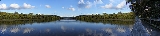
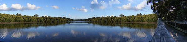
Salt Pan Creek is a small creek located in the Salt Pan Creek catchment area, in south-western
Sydney
, in the state of New South Wales
, Australia
. It is located between the suburbs of Padstow
and Riverwood
and feeds into the Georges River
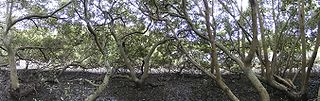
. The catchment area covers about 26km2, with 11.7km2 of this being located in the local government area of Bankstown. The creek is now subject to flooding
due to vegetation
modification and urban development
..
 Prior to 1926, Salt Pan Creek was the site of an Aboriginal
squatters camp consisting of refugee families of the dispossessed and those seeking to escape the brutal policies of the Aboriginal Protection Board
. From 1926 to 1935, it became a focal point of Aboriginal resistance in New South Wales
.
Salt Pan Creek was named after a popular watering place on the Kent
ish coast in England
.
South-western Sydney
South-western Sydney is a general term which is used to describe the metropolitan area in south-west Sydney, New South Wales, Australia. It is part of the Greater Western Sydney area....
Sydney
Sydney
Sydney is the most populous city in Australia and the state capital of New South Wales. Sydney is located on Australia's south-east coast of the Tasman Sea. As of June 2010, the greater metropolitan area had an approximate population of 4.6 million people...
, in the state of New South Wales
New South Wales
New South Wales is a state of :Australia, located in the east of the country. It is bordered by Queensland, Victoria and South Australia to the north, south and west respectively. To the east, the state is bordered by the Tasman Sea, which forms part of the Pacific Ocean. New South Wales...
, Australia
Australia
Australia , officially the Commonwealth of Australia, is a country in the Southern Hemisphere comprising the mainland of the Australian continent, the island of Tasmania, and numerous smaller islands in the Indian and Pacific Oceans. It is the world's sixth-largest country by total area...
. It is located between the suburbs of Padstow
Padstow, New South Wales
Padstow, a suburb of local government area City of Bankstown, is located 22 kilometres inner south-west of the Sydney central business district, in the state of New South Wales, Australia, and is a part of the South-western Sydney region....
and Riverwood
Riverwood, New South Wales
Riverwood is a suburb in southern Sydney, in the state of New South Wales, Australia. Riverwood is located 18 kilometres south-west of the Sydney central business district and is part of the St George area...
and feeds into the Georges River
Georges River
The Georges River is a waterway in the state of New South Wales in Australia. It rises to the south-west of Sydney near the coal mining town of Appin, and then flows north past Campbelltown, roughly parallel to the Main South Railway...
. The catchment area covers about 26km2, with 11.7km2 of this being located in the local government area of Bankstown. The creek is now subject to flooding
Flood
A flood is an overflow of an expanse of water that submerges land. The EU Floods directive defines a flood as a temporary covering by water of land not normally covered by water...
due to vegetation
Vegetation
Vegetation is a general term for the plant life of a region; it refers to the ground cover provided by plants. It is a general term, without specific reference to particular taxa, life forms, structure, spatial extent, or any other specific botanical or geographic characteristics. It is broader...
modification and urban development
Urbanization
Urbanization, urbanisation or urban drift is the physical growth of urban areas as a result of global change. The United Nations projected that half of the world's population would live in urban areas at the end of 2008....
..
History
Indigenous Australians
Indigenous Australians are the original inhabitants of the Australian continent and nearby islands. The Aboriginal Indigenous Australians migrated from the Indian continent around 75,000 to 100,000 years ago....
squatters camp consisting of refugee families of the dispossessed and those seeking to escape the brutal policies of the Aboriginal Protection Board
Aboriginal Protection Board
There was an Aboriginal Protection Board in a number of Australian States with the function of "protecting" and regulating the lives of Indigenous Australians. They were also responsible for administering the various Half-caste acts where these existed and had a key role in the Stolen generations...
. From 1926 to 1935, it became a focal point of Aboriginal resistance in New South Wales
New South Wales
New South Wales is a state of :Australia, located in the east of the country. It is bordered by Queensland, Victoria and South Australia to the north, south and west respectively. To the east, the state is bordered by the Tasman Sea, which forms part of the Pacific Ocean. New South Wales...
.
Salt Pan Creek was named after a popular watering place on the Kent
Kent
Kent is a county in southeast England, and is one of the home counties. It borders East Sussex, Surrey and Greater London and has a defined boundary with Essex in the middle of the Thames Estuary. The ceremonial county boundaries of Kent include the shire county of Kent and the unitary borough of...
ish coast in England
England
England is a country that is part of the United Kingdom. It shares land borders with Scotland to the north and Wales to the west; the Irish Sea is to the north west, the Celtic Sea to the south west, with the North Sea to the east and the English Channel to the south separating it from continental...
.