

Geography of Minneapolis, Minnesota
Encyclopedia
Minneapolis
is the largest city
in the state of Minnesota
in the United States
, and the county seat
of Hennepin County
.
 According to the United States Census Bureau
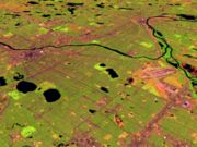
, the city has a total area of 151.3 km² (58.4 mi²). 142.2 km² (54.9 mi²) of it is land and 9.1 km² (3.5 mi²) of it (6.01%) is water. The city center is located just south of 45 degrees north latitude
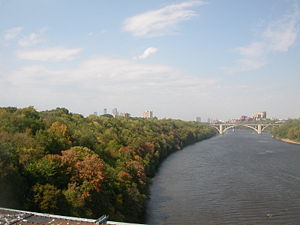
. On the south side of Golden Valley Road just east of Wirth Parkway, a stone containing a weathered plaque marks a point on the 45th parallel. The Mississippi, which runs to the southeast, directed the early growth of the city. Most early streets ran parallel to the river to maximize the amount of land that could be used. Eventually, growth of Minneapolis turned to north-south and east-west streets. Many unique intersections like Seven Corners on the eastern periphery of downtown were formed to translate between the two layouts. Some streets, especially older and more traditionally important ones like Hennepin Avenue
and Nicollet Avenue
, have both orientations at different points.
 Minneapolis has a large park system consisting of ten square miles (26 km²) of land and water that is interlinked in many places. Theodore Wirth
is often credited with the development of this system that brought a playground within the reach of most children and the canopy of trees and boulevards in much of the city. The Mississippi National River and Recreation Area
connects regional parks and visitors centers.
Theodore Wirth Park
is the largest in the city, shared with Golden Valley
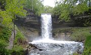
, and is about 60% the size of Central Park in New York City. Minnehaha Park is one of the most famous, the site of Minnehaha Falls
and cultural heritage events every year. Tower Hill Park in Prospect Park
is the home of a 1913 water tower, the highest point in Minneapolis.
The Grand Rounds Scenic Byway
circles through the city and many of the larger park areas including land along the Mississippi, lakes and scenic areas. A parkway
for cars, a bikeway for riders, and a walkway for pedestrians run parallel paths along the 50-mile route. A growing number of bikeways and walkways crisscross the city and interconnect with neighboring cities.
Twenty four small lakes are within the city limits. Among the largest freshwater lakes to the west are Lake Harriet, Lake Calhoun
, Lake of the Isles
, and Cedar Lake
, known together as the "Chain of Lakes
". Lake Nokomis
and Lake Hiawatha
are to the east. Connected by bike, running and walking paths, Minneapolis lakes are used for swimming, fishing, picnics and boating.


, under a 16 foot (5 m) thick layer of shale
, under a 35 foot (11 m) thick layer of Platteville limestone
. These layers were the result of an Ordovician Period sea which covered east-central Minnesota 500 million years ago. The hard limestone cap was formed from fossilized shell fish. About 20,000 years ago, the area was covered by the Superior Lobe of the Laurentide ice sheet
, which left the St. Croix moraine
on the Twin Cities as it receded. Later the Grantsburg Sublobe of the Des Moines Lobe also covered the area. Under these vast layers of ice, tunnel valley
s were formed, cutting through the limestone layer with tremendous force, to release ice meltwater and glacier effluence. The result was a series of troughs in the limestone, which were filled by glacial till and outwash deposit as the glaciers receded. Sometimes the sediment would be mixed with huge chunks of ice, which would leave voids in the soil. These voids created basins for the Twin Cities Lakes, such as Harriet and Lake Calhoun
. Connecting the city lakes in several north-south arteries are gorges cut through the bedrock, but filled with sand and sediment.
When River Warren Falls
receded past the confluence of the much smaller Upper Mississippi River
, a new waterfall was created where that river entered the much-lower glacial River Warren
. The new falls also receded upstream on the Mississippi, migrating eight miles (12875 m) over 9600 years to where Louis Hennepin
first saw it and named St. Anthony Falls in 1680. Due to its value as a power source, this waterfall determined the location of Minneapolis. One branch of the river coming from the west, Minnehaha Creek receded only a few hundred yards from one of the channels of the Mississippi. Minnehaha Falls
remains as a picturesque and informative relic of River Warren Falls, and the limestone-over-sandstone construction is readily apparent in its small gorge.
Minneapolis, Minnesota
Minneapolis , nicknamed "City of Lakes" and the "Mill City," is the county seat of Hennepin County, the largest city in the U.S. state of Minnesota, and the 48th largest in the United States...
is the largest city
City
A city is a relatively large and permanent settlement. Although there is no agreement on how a city is distinguished from a town within general English language meanings, many cities have a particular administrative, legal, or historical status based on local law.For example, in the U.S...
in the state of Minnesota
Minnesota
Minnesota is a U.S. state located in the Midwestern United States. The twelfth largest state of the U.S., it is the twenty-first most populous, with 5.3 million residents. Minnesota was carved out of the eastern half of the Minnesota Territory and admitted to the Union as the thirty-second state...
in the United States
United States
The United States of America is a federal constitutional republic comprising fifty states and a federal district...
, and the county seat
County seat
A county seat is an administrative center, or seat of government, for a county or civil parish. The term is primarily used in the United States....
of Hennepin County
Hennepin County, Minnesota
Hennepin County is a county located in the U.S. state of Minnesota, named in honor of the 17th-century explorer Father Louis Hennepin. As of 2010 the population was 1,152,425. Its county seat is Minneapolis. It is by far the most populous county in Minnesota; more than one in five Minnesotans live...
.
Physical
United States Census Bureau
The United States Census Bureau is the government agency that is responsible for the United States Census. It also gathers other national demographic and economic data...
, the city has a total area of 151.3 km² (58.4 mi²). 142.2 km² (54.9 mi²) of it is land and 9.1 km² (3.5 mi²) of it (6.01%) is water. The city center is located just south of 45 degrees north latitude
Latitude
In geography, the latitude of a location on the Earth is the angular distance of that location south or north of the Equator. The latitude is an angle, and is usually measured in degrees . The equator has a latitude of 0°, the North pole has a latitude of 90° north , and the South pole has a...
. On the south side of Golden Valley Road just east of Wirth Parkway, a stone containing a weathered plaque marks a point on the 45th parallel. The Mississippi, which runs to the southeast, directed the early growth of the city. Most early streets ran parallel to the river to maximize the amount of land that could be used. Eventually, growth of Minneapolis turned to north-south and east-west streets. Many unique intersections like Seven Corners on the eastern periphery of downtown were formed to translate between the two layouts. Some streets, especially older and more traditionally important ones like Hennepin Avenue
Hennepin Avenue
Hennepin Avenue is a major street in Minneapolis, Minnesota, United States. It runs from Lakewood Cemetery , north through the Uptown District of Southwest Minneapolis, through the former "Bottleneck" area west of Loring Park, through the North Loop in the city center, to Northeast Minneapolis and...
and Nicollet Avenue
Nicollet Avenue
Nicollet Avenue is a major street in Minneapolis, Minnesota, and three of its suburbs. It passes through a number of locally well-known neighborhoods and districts, notably Eat Street in south Minneapolis and the traffic-restricted Nicollet Mall in the city's downtown.It began as a military road...
, have both orientations at different points.
Parks and lakes
Theodore Wirth
Theodore Wirth was instrumental in designing the Minneapolis system of parks. Swiss-born, he was widely regarded as the dean of the local parks movement in America. The various titles he was given included administrator of parks, horticulturalist, and park planner. Before emigrating to America...
is often credited with the development of this system that brought a playground within the reach of most children and the canopy of trees and boulevards in much of the city. The Mississippi National River and Recreation Area
Mississippi National River and Recreation Area
The Mississippi National River and Recreation Area protects a and corridor along the Mississippi River from the cities of Dayton and Ramsey, Minnesota to just downstream of Hastings, Minnesota. This includes the stretch of Mississippi River which flows through Minneapolis and St. Paul, Minnesota...
connects regional parks and visitors centers.
Theodore Wirth Park
Theodore Wirth Park
Theodore Wirth Park is the largest park managed by the Minneapolis Park and Recreation Board. The park land is shared by Minneapolis and the neighboring suburb of Golden Valley. The park includes two golf courses , Wirth Lake, Birch Pond, and other amenities...
is the largest in the city, shared with Golden Valley
Golden Valley, Minnesota
As of the census of 2000, there were 20,281 people, 8,449 households, and 5,508 families residing in the city. The population density was 1,982.3 people per square mile . There were 8,589 housing units at an average density of 839.5 per square mile...
, and is about 60% the size of Central Park in New York City. Minnehaha Park is one of the most famous, the site of Minnehaha Falls
Minnehaha Falls
Minnehaha Creek is a tributary of the Mississippi River located in Hennepin County, Minnesota that extends from Lake Minnetonka in the west and flows east for 22 miles through several suburbs west of Minneapolis and then through south Minneapolis. Including Lake Minnetonka, the watershed for the...
and cultural heritage events every year. Tower Hill Park in Prospect Park
Prospect Park, Minneapolis
Prospect Park is an historic neighborhood within the University community of the U.S. city of Minneapolis, Minnesota. The area is bounded by the Mississippi River to the south, the City of Saint Paul, Minnesota to the east, the Burlington Northern railroad yard to the north, and the Stadium...
is the home of a 1913 water tower, the highest point in Minneapolis.
The Grand Rounds Scenic Byway
Grand Rounds Scenic Byway
The Grand Rounds Scenic Byway is a linked series of park areas in Minneapolis, Minnesota that takes a roughly circular path through the city. The corridors include roads for automobile traffic plus paths for pedestrians and bicycles, and extend slightly into neighboring cities...
circles through the city and many of the larger park areas including land along the Mississippi, lakes and scenic areas. A parkway
Parkway
The term parkway has several distinct principal meanings and numerous synonyms around the world, for either a type of landscaped area or a type of road.Type of landscaped area:...
for cars, a bikeway for riders, and a walkway for pedestrians run parallel paths along the 50-mile route. A growing number of bikeways and walkways crisscross the city and interconnect with neighboring cities.
Twenty four small lakes are within the city limits. Among the largest freshwater lakes to the west are Lake Harriet, Lake Calhoun
Lake Calhoun
Lake Calhoun is the biggest lake in Minneapolis, Minnesota, and part of the city's Chain of Lakes. Surrounded by city park land and circled by bike and walking trails, it is popular for many outdoor activities...
, Lake of the Isles
Lake of the Isles
Lake of the Isles is a lake in Minneapolis, Minnesota connected to Cedar Lake and Lake Calhoun. It is home to winter ice skating and hockey, as well as a New Year's Eve celebration featuring roasted marshmallows and hot chocolate...
, and Cedar Lake
Cedar Lake (Minnesota)
Cedar Lake is a lake on the west side of Minneapolis, north of Lake Calhoun and west of Lake of the Isles. The lake is surrounded by parkland on the west side, while the east side borders the Kenwood residential area. The north side is bordered by the Cedar Lake Trail and the BNSF Railway...
, known together as the "Chain of Lakes
Chain of Lakes (Minneapolis)
The Chain of Lakes is a district in Minneapolis, Minnesota. It is one of seven districts that make up the Grand Rounds Scenic Byway, a greenspace circling through the city...
". Lake Nokomis
Lake Nokomis
Lake Nokomis is one of several lakes in Minneapolis, Minnesota. The lake was originally named Lake Amelia in honor of Captain George Gooding’s daughter, Amelia, in 1819. Its current name was adopted in 1910 to honor Nokomis, grandmother of Hiawatha...
and Lake Hiawatha
Lake Hiawatha
Lake Hiawatha is located just north of Lake Nokomis in Minneapolis, Minnesota. It was purchased by the Minneapolis park system in 1922 for $550,000. At that time the lake was just a swamp, but over four years, the park system transformed the bog into a beautiful lake surrounded by a...
are to the east. Connected by bike, running and walking paths, Minneapolis lakes are used for swimming, fishing, picnics and boating.
Flora and fauna
Waterfalls
The area now occupied by the Twin Cities generally consisted of a 155 foot (47 m) thick layer of St. Peter SandstoneSt. Peter Sandstone
The St. Peter Sandstone is an Ordovician formation in the Chazyan stage of the Champlainian series. This sandstone originated as a sheet of sand in clear, shallow water near the shore of a Paleozoic sea and consists of fine-to-medium-size, well-rounded quartz grains with frosted surfaces...
, under a 16 foot (5 m) thick layer of shale
Shale
Shale is a fine-grained, clastic sedimentary rock composed of mud that is a mix of flakes of clay minerals and tiny fragments of other minerals, especially quartz and calcite. The ratio of clay to other minerals is variable. Shale is characterized by breaks along thin laminae or parallel layering...
, under a 35 foot (11 m) thick layer of Platteville limestone
Platteville Limestone
The Platteville Limestone is the Ordivician limestone formation in the sedimentary sequence characteristic of the upper Midwestern United States. It overlies the thin Glenwood Shale, which overlies the thick Saint Peter Sandstone...
. These layers were the result of an Ordovician Period sea which covered east-central Minnesota 500 million years ago. The hard limestone cap was formed from fossilized shell fish. About 20,000 years ago, the area was covered by the Superior Lobe of the Laurentide ice sheet
Laurentide ice sheet
The Laurentide Ice Sheet was a massive sheet of ice that covered hundreds of thousands of square miles, including most of Canada and a large portion of the northern United States, multiple times during Quaternary glacial epochs. It last covered most of northern North America between c. 95,000 and...
, which left the St. Croix moraine
Moraine
A moraine is any glacially formed accumulation of unconsolidated glacial debris which can occur in currently glaciated and formerly glaciated regions, such as those areas acted upon by a past glacial maximum. This debris may have been plucked off a valley floor as a glacier advanced or it may have...
on the Twin Cities as it receded. Later the Grantsburg Sublobe of the Des Moines Lobe also covered the area. Under these vast layers of ice, tunnel valley
Tunnel valley
A tunnel valley is a large, long, U-shaped valley originally cut under the glacial ice near the margin of continental ice sheets such as that now covering Antarctica and formerly covering portions of all continents during past glacial ages....
s were formed, cutting through the limestone layer with tremendous force, to release ice meltwater and glacier effluence. The result was a series of troughs in the limestone, which were filled by glacial till and outwash deposit as the glaciers receded. Sometimes the sediment would be mixed with huge chunks of ice, which would leave voids in the soil. These voids created basins for the Twin Cities Lakes, such as Harriet and Lake Calhoun
Lake Calhoun
Lake Calhoun is the biggest lake in Minneapolis, Minnesota, and part of the city's Chain of Lakes. Surrounded by city park land and circled by bike and walking trails, it is popular for many outdoor activities...
. Connecting the city lakes in several north-south arteries are gorges cut through the bedrock, but filled with sand and sediment.
When River Warren Falls
River Warren Falls
The River Warren Falls was a massive waterfall on the glacial River Warren initially located in present-day Saint Paul, Minnesota, United States. The waterfall was 2700 feet across and 175 feet high.-Geologic history:...
receded past the confluence of the much smaller Upper Mississippi River
Upper Mississippi River
The Upper Mississippi River is the portion of the Mississippi River upstream of Cairo, Illinois, United States. From the headwaters at Lake Itasca, Minnesota, the river flows approximately 2000 kilometers to Cairo, where it is joined by the Ohio River to form the Lower Mississippi...
, a new waterfall was created where that river entered the much-lower glacial River Warren
Glacial River Warren
right|thumb|210px|The course of the Minnesota River follows the valley carved by Glacial River WarrenGlacial River Warren or River Warren was a prehistoric river that drained Lake Agassiz in central North America between 11,700 and 9,400 years ago...
. The new falls also receded upstream on the Mississippi, migrating eight miles (12875 m) over 9600 years to where Louis Hennepin
Louis Hennepin
Father Louis Hennepin, O.F.M. baptized Antoine, was a Catholic priest and missionary of the Franciscan Recollect order and an explorer of the interior of North America....
first saw it and named St. Anthony Falls in 1680. Due to its value as a power source, this waterfall determined the location of Minneapolis. One branch of the river coming from the west, Minnehaha Creek receded only a few hundred yards from one of the channels of the Mississippi. Minnehaha Falls
Minnehaha Falls
Minnehaha Creek is a tributary of the Mississippi River located in Hennepin County, Minnesota that extends from Lake Minnetonka in the west and flows east for 22 miles through several suburbs west of Minneapolis and then through south Minneapolis. Including Lake Minnetonka, the watershed for the...
remains as a picturesque and informative relic of River Warren Falls, and the limestone-over-sandstone construction is readily apparent in its small gorge.