

Nicollet Avenue
Encyclopedia
Minneapolis, Minnesota
Minneapolis , nicknamed "City of Lakes" and the "Mill City," is the county seat of Hennepin County, the largest city in the U.S. state of Minnesota, and the 48th largest in the United States...
, and three of its suburbs. It passes through a number of locally well-known neighborhoods and districts, notably Eat Street in south Minneapolis and the traffic-restricted Nicollet Mall
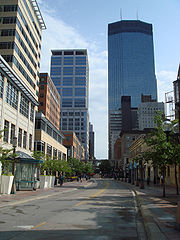
Nicollet Mall
Nicollet Mall is a portion of Nicollet Avenue running through downtown Minneapolis, Minnesota, United States. Working as a pedestrian and transit mall, it is also an upscale shopping and dining district...
in the city's downtown.
It began as a military road between St. Anthony Falls and Fort Snelling. Nicollet Avenue was named for early 19th-century French explorer and mapmaker Joseph Nicollet
Joseph Nicollet
Joseph Nicolas Nicollet , also known as Jean-Nicolas Nicollet, was a French geographer and mathematician known for mapping the Upper Mississippi River basin during the 1830s....
, who led three expeditions in what is now Minnesota. Nicollet Mall
Nicollet Mall
Nicollet Mall is a portion of Nicollet Avenue running through downtown Minneapolis, Minnesota, United States. Working as a pedestrian and transit mall, it is also an upscale shopping and dining district...
occupies the oldest section of the avenue. Before the mall was constructed in 1968, Nicollet Avenue stretched from the Mississippi River
Mississippi River
The Mississippi River is the largest river system in North America. Flowing entirely in the United States, this river rises in western Minnesota and meanders slowly southwards for to the Mississippi River Delta at the Gulf of Mexico. With its many tributaries, the Mississippi's watershed drains...
to the Minnesota River
Minnesota River
The Minnesota River is a tributary of the Mississippi River, approximately 332 miles long, in the U.S. state of Minnesota. It drains a watershed of nearly , in Minnesota and about in South Dakota and Iowa....
.
Technically, the avenue begins at Grant Street in Loring Park
Loring Park
Loring Park is the largest park in the Central Community of Minneapolis, Minnesota on the southwest corner of downtown Minneapolis. It also lends its name to the surrounding neighborhood.- Park :...
and continues south to West 29th Street/Cecil B. Newman Lane, where it is interrupted by a K-Mart store, and begins again at Lake Street, continuing through Richfield
Richfield, Minnesota
As of the census of 2000, there were 34,439 people, 15,073 households, and 8,727 families residing in the city. The population density was 4,993.9 people per square mile . There were 15,357 housing units at an average density of 2,226.9 per square mile...
and Bloomington
Bloomington, Minnesota
Bloomington is the fifth largest city in the U.S. state of Minnesota in Hennepin County. Located on the north bank of the Minnesota River above its confluence with the Mississippi River, Bloomington lies at the heart of the southern...
to 107th Street just north of the Minnesota River
Minnesota River
The Minnesota River is a tributary of the Mississippi River, approximately 332 miles long, in the U.S. state of Minnesota. It drains a watershed of nearly , in Minnesota and about in South Dakota and Iowa....
. Across the river in Burnsville
Burnsville, Minnesota
Burnsville is a city south of downtown Minneapolis in Dakota County in the U.S. state of Minnesota. The city lies on the south bank of the Minnesota River, upstream from the confluence with the Mississippi River...
, Nicollet begins again at Cliff Road West and ends at County Road 42.
One block of the street between 29th Street and Lake Street
Lake Street (Minneapolis)
Lake Street is a major east-west thoroughfare in Minneapolis, Minnesota which is located between 29th and 31st Streets in south Minneapolis. It was named such because it runs through the Chain of Lakes area on the west side of town and passes over a small channel linking Lake Calhoun and Lake of...
was removed in the 1970s to build a K-Mart store which covers two city blocks, detouring southbound traffic to Blaisdell Avenue and northbound traffic to First Avenue South. The city of Minneapolis has plans to restore Nicollet Avenue starting in 2014 by reconstructing the K-Mart site into a new configuration that would include both commercial and residential development.
The Metro Transit
Metro Transit (Minnesota)
Metro Transit is the transit division of the Metropolitan Council, a regional governmental agency in the Minneapolis-St. Paul metro area of the U.S. state of Minnesota. Metro Transit is the largest operator of bus services in the seven-county region surrounding Minneapolis and St...
route 18 bus travels most of Nicollet Avenue. Historically, Nicollet had rail transportation, starting with the Minneapolis, Lyndale & Minnetonka Railway Co., also known as the "Motor Line". The Motor Line ran along Marquette Avenue in downtown Minneapolis, then turned west for one block at 13th Street South to reach Nicollet. The line was constructed south to 31st Street in 1879, to 37th Street in 1884, and was extended further south to 50th Street in 1887. It was converted to streetcar operation in 1890, and the Twin City Rapid Transit Company (TCRT) extended the route to Diamond Lake Road in 1911, 58th Street in 1928, and 62nd Street (now Minnesota State Highway 62
Minnesota State Highway 62 (east)
Minnesota State Highway 62 is a highway in the Twin Cities region of Minnesota. The route was part of Hennepin County Road 62 until 1988, when a portion of the route was inherited by the state. The western terminus of the route is at Interstate Highway 494 in Eden Prairie, where the roadway...
) in 1947. Streetcars on the road had a service frequency of one every 5 minutes off-peak, and ran about twice as often during the morning and afternoon peak periods.
The Dan Patch Line, a separate railroad serving communities as far south as Northfield, Minnesota
Northfield, Minnesota
As of the census of 2000, there were 17,147 people, 4,909 households, and 3,210 families residing in the city. The population density was 2,452.2 people per square mile . There were 5,119 housing units at an average density of 732.1 per square mile...
, ran parallel to the streetcar line between 60th Street and Diamond Lake Road. Nicollet Station, a carhouse originally built for the Motor Line, was kept and expanded by TCRT, but was torn down as the system was dismantled in 1953–1954. The station was located at Nicollet and 31st Street, just south of the Minneapolis Millers
Minneapolis Millers
The Minneapolis Millers were an American professional minor league baseball team that played in Minneapolis, Minnesota, until 1960. In the 19th century a different Minneapolis Millers were part of the Western League.The team played first in Athletic Park and later Nicollet Park.The name Minneapolis...
' Nicollet Park
Nicollet Park
Nicollet Park is a former baseball ground located in Minneapolis, Minnesota, United States. The ground was home to the minor league Minneapolis Millers of the Western League and later American Association from 1896 to 1955. During its first season it was officially known as Wright Field name for...
baseball field, which itself closed in 1955.
In popular culture
The avenue was used as a backdrop for the end of the famous opening sequence of The Mary Tyler Moore ShowThe Mary Tyler Moore Show
The Mary Tyler Moore Show is an American television sitcom created by James L. Brooks and Allan Burns that aired on CBS from 1970 to 1977...
, in which a jubilant Moore tosses her hat into the air while watched by a curious group of passersby who were, in fact, real people and not extras.