Geography of American Samoa
Encyclopedia
American Samoa
, located within the geographical region of Oceania
, is one of only two possessions of the United States
in the Southern Hemisphere
, the other being Jarvis Island
. Its total land area is 76.8 square miles (198.9 km²) -- slightly larger than Washington, D.C.
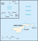
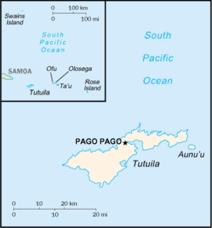
-- consisting of five rugged, volcanic islands and two coral atolls. The five volcanic islands islands are: Tutuila
, Aunu'u
, Ofu
, Olosega
, Tau
. The coral atolls are: Swains
, and Rose Atoll
. Of the seven islands, Rose Atoll is an uninhabited Marine National Monument.
Due to its positioning in the South Pacific Ocean, it is frequently hit by typhoons between December and March. Rose Atoll is the easternmost point of the territory. American Samoa is the southernmost part of the United States. American Samoa is home to the National Park of American Samoa
.
American Samoa
American Samoa is an unincorporated territory of the United States located in the South Pacific Ocean, southeast of the sovereign state of Samoa...
, located within the geographical region of Oceania
Oceania
Oceania is a region centered on the islands of the tropical Pacific Ocean. Conceptions of what constitutes Oceania range from the coral atolls and volcanic islands of the South Pacific to the entire insular region between Asia and the Americas, including Australasia and the Malay Archipelago...
, is one of only two possessions of the United States
United States
The United States of America is a federal constitutional republic comprising fifty states and a federal district...
in the Southern Hemisphere
Southern Hemisphere
The Southern Hemisphere is the part of Earth that lies south of the equator. The word hemisphere literally means 'half ball' or "half sphere"...
, the other being Jarvis Island
Jarvis Island
Jarvis Island is an uninhabited 4.5 square kilometer coral island located in the South Pacific Ocean at , about halfway between Hawaii and the Cook Islands...
. Its total land area is 76.8 square miles (198.9 km²) -- slightly larger than Washington, D.C.
Washington, D.C.
Washington, D.C., formally the District of Columbia and commonly referred to as Washington, "the District", or simply D.C., is the capital of the United States. On July 16, 1790, the United States Congress approved the creation of a permanent national capital as permitted by the U.S. Constitution....
-- consisting of five rugged, volcanic islands and two coral atolls. The five volcanic islands islands are: Tutuila
Tutuila
Tutuila is the largest and the main island of American Samoa in the archipelago of Samoan Islands. It is the third largest island in the Samoan Islands chain of the Central Pacific located roughly northeast of Brisbane, Australia and over northeast of Fiji. It contains a large, natural harbor,...
, Aunu'u
Aunu'u
Aunu'u is a small volcanic island off the southeastern shore of Tutuila in American Samoa. It has a land area of and a 2000 census population of 476 persons. Politically it is a part of the Eastern District, one of the primary divisions of American Samoa....
, Ofu
Ofu-Olosega
Ofu and Olosega are parts of a volcanic doublet in the Manu‘a Group of the Samoan Islands—part of American Samoa. The twin islands, formed from shield volcanoes, have a combined length of 6km. They are geographic volcanic remnants separated by the narrow 137m wide Asaga strait, a natural...
, Olosega
Ofu-Olosega
Ofu and Olosega are parts of a volcanic doublet in the Manu‘a Group of the Samoan Islands—part of American Samoa. The twin islands, formed from shield volcanoes, have a combined length of 6km. They are geographic volcanic remnants separated by the narrow 137m wide Asaga strait, a natural...
, Tau
Tau, American Samoa
Ta‘ū is the largest island in the Manu‘a Group and the easternmost volcanic island of the Samoan Islands. Ta‘ū is part of American Samoa. In the early 19th century, the island was sometimes called Opoun....
. The coral atolls are: Swains
Swains Island
Swains Island is an atoll in the Tokelau chain. Culturally a part of Tokelau, it is an unincorporated unorganized territory of the United States administered by American Samoa. Swains Island has also been known at various times as Olosenga Island, Olohega Island, Quiros Island, Gente Hermosa...
, and Rose Atoll
Rose Atoll
Rose Atoll, sometimes called Rose Island or Motu O Manu by people of the nearby Manu'a Islands, is an oceanic atoll within the U.S. territory of American Samoa. It is an uninhabited wildlife refuge. It is the southernmost point in the United States. The land area is 0.214 km²...
. Of the seven islands, Rose Atoll is an uninhabited Marine National Monument.
Due to its positioning in the South Pacific Ocean, it is frequently hit by typhoons between December and March. Rose Atoll is the easternmost point of the territory. American Samoa is the southernmost part of the United States. American Samoa is home to the National Park of American Samoa
National Park of American Samoa
The National Park of American Samoa is a national park on the American territory of American Samoa, distributed across three separate islands: Tutuila, Ofu-Olosega, and Ta‘ū. The park includes coral reefs and rain forest and is popular for hiking, snorkeling, and scuba diving, although the primary...
.
|
||
| Continent Continent A continent is one of several very large landmasses on Earth. They are generally identified by convention rather than any strict criteria, with seven regions commonly regarded as continents—they are : Asia, Africa, North America, South America, Antarctica, Europe, and Australia.Plate tectonics is... |
Oceania Oceania Oceania is a region centered on the islands of the tropical Pacific Ocean. Conceptions of what constitutes Oceania range from the coral atolls and volcanic islands of the South Pacific to the entire insular region between Asia and the Americas, including Australasia and the Malay Archipelago... |
|
| Subregion Subregion A subregion is a conceptual unit which derives from a larger region or continent and is usually based on location. Cardinal directions, such as south or southern, are commonly used to define a subregion.- United Nations subregions :... |
Oceania Oceania Oceania is a region centered on the islands of the tropical Pacific Ocean. Conceptions of what constitutes Oceania range from the coral atolls and volcanic islands of the South Pacific to the entire insular region between Asia and the Americas, including Australasia and the Malay Archipelago... |
|
| Geographic coordinates | 14°20′S 170°00′W | |
| Area Area Area is a quantity that expresses the extent of a two-dimensional surface or shape in the plane. Area can be understood as the amount of material with a given thickness that would be necessary to fashion a model of the shape, or the amount of paint necessary to cover the surface with a single coat... - Total - Water |
Ranked 212th 199 km² 0 km² |
|
| Coastline | 116 km | |
| Land boundaries | 0 km | |
| Countries bordered | none | |
| Maritime claims | 200 nmi (370.4 km) | |
| Highest point | Lata Mountain, 964 m | |
| Lowest point | Pacific Ocean Pacific Ocean The Pacific Ocean is the largest of the Earth's oceanic divisions. It extends from the Arctic in the north to the Southern Ocean in the south, bounded by Asia and Australia in the west, and the Americas in the east.At 165.2 million square kilometres in area, this largest division of the World... , 0 m |
|
| Longest river | ||
| Largest inland body of water | ||
| Land Use - Arable land - Permanent crops - Other |
10 % 15 % 75 % (2005 est.) |
|
| Irrigated Land: | n/a | |
| Climate Climate Climate encompasses the statistics of temperature, humidity, atmospheric pressure, wind, rainfall, atmospheric particle count and other meteorological elemental measurements in a given region over long periods... : |
tropical marine Tropical marine ecosystem Islands and coastal areas 10° to 20° north or south of the equator usually have a tropical marine climate.The ocean is the main influence in creating the tropical marine system climate.... , little seasonal temperature variation |
|
| Terrain Terrain Terrain, or land relief, is the vertical and horizontal dimension of land surface. When relief is described underwater, the term bathymetry is used... : |
volcano Volcano 2. Bedrock3. Conduit 4. Base5. Sill6. Dike7. Layers of ash emitted by the volcano8. Flank| 9. Layers of lava emitted by the volcano10. Throat11. Parasitic cone12. Lava flow13. Vent14. Crater15... , limited coastal plain Plain In geography, a plain is land with relatively low relief, that is flat or gently rolling. Prairies and steppes are types of plains, and the archetype for a plain is often thought of as a grassland, but plains in their natural state may also be covered in shrublands, woodland and forest, or... s, two coral atoll Atoll An atoll is a coral island that encircles a lagoon partially or completely.- Usage :The word atoll comes from the Dhivehi word atholhu OED... s |
|
| Natural resources | pumice Pumice Pumice is a textural term for a volcanic rock that is a solidified frothy lava typically created when super-heated, highly pressurized rock is violently ejected from a volcano. It can be formed when lava and water are mixed. This unusual formation is due to the simultaneous actions of rapid... , pumicite |
|
| Natural hazards | typhoons from December to March | |
| Environmental issues | limited fresh water Fresh Water Fresh Water is the debut album by Australian rock and blues singer Alison McCallum, released in 1972. Rare for an Australian artist at the time, it came in a gatefold sleeve... |
|
See also
- Samoan IslandsSamoan IslandsThe Samoan Islands or Samoa Islands is an archipelago covering in the central South Pacific, forming part of Polynesia and the wider region of Oceania...
- Geography of SamoaGeography of SamoaThe independent country of Samoa consists of the two large islands of Upolu and Savai'i and 8 smaller islands located about halfway between Hawaii and New Zealand in the Polynesian region of the South Pacific....
- Swamps of American SamoaSwamps of American SamoaThis is a list of swamps in American Samoa, categorized by island.There are four marshes on the island of Tutuila:*Faimulivai Marsh: This freshwater marsh in Aunu'u Crater is the largest such wetland in American Samoa. It was formed from drainage of the low-lying crater. It is part of a protected...


