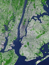
Geography and environment of New York City
Encyclopedia
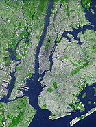
New York City
New York is the most populous city in the United States and the center of the New York Metropolitan Area, one of the most populous metropolitan areas in the world. New York exerts a significant impact upon global commerce, finance, media, art, fashion, research, technology, education, and...
is characterized by its coastal position at the meeting of the Hudson River
Hudson River
The Hudson is a river that flows from north to south through eastern New York. The highest official source is at Lake Tear of the Clouds, on the slopes of Mount Marcy in the Adirondack Mountains. The river itself officially begins in Henderson Lake in Newcomb, New York...
and the Atlantic Ocean
Atlantic Ocean
The Atlantic Ocean is the second-largest of the world's oceanic divisions. With a total area of about , it covers approximately 20% of the Earth's surface and about 26% of its water surface area...
in a naturally sheltered harbor. The city's geography, with its scarce availability of land, is a contributing factor in making New York City
New York City
New York is the most populous city in the United States and the center of the New York Metropolitan Area, one of the most populous metropolitan areas in the world. New York exerts a significant impact upon global commerce, finance, media, art, fashion, research, technology, education, and...
the most densely populated city in the United States
United States
The United States of America is a federal constitutional republic comprising fifty states and a federal district...
with a population over 100,000. Environmental issues are chiefly concerned with managing this density, which also explains why New York is among the most energy efficient and least automobile-dependent cities in the United States. The city's climate is temperate.
Geography
New York City is located on the coast of the Northeastern United StatesNortheastern United States
The Northeastern United States is a region of the United States as defined by the United States Census Bureau.-Composition:The region comprises nine states: the New England states of Connecticut, Maine, Massachusetts, New Hampshire, Rhode Island and Vermont; and the Mid-Atlantic states of New...
at the mouth of the Hudson River
Hudson River
The Hudson is a river that flows from north to south through eastern New York. The highest official source is at Lake Tear of the Clouds, on the slopes of Mount Marcy in the Adirondack Mountains. The river itself officially begins in Henderson Lake in Newcomb, New York...
in southeastern New York
New York
New York is a state in the Northeastern region of the United States. It is the nation's third most populous state. New York is bordered by New Jersey and Pennsylvania to the south, and by Connecticut, Massachusetts and Vermont to the east...
state. The New York Harbor
New York Harbor
New York Harbor refers to the waterways of the estuary near the mouth of the Hudson River that empty into New York Bay. It is one of the largest natural harbors in the world. Although the U.S. Board of Geographic Names does not use the term, New York Harbor has important historical, governmental,...
, with its deep waters and sheltered bays, helped the city grow in significance as a trading city. Much of New York is built on the three islands of Manhattan, Staten Island, and western Long Island, making land scarce and encouraging a high population density.
The Hudson River flows from the Hudson Valley
Hudson Valley
The Hudson Valley comprises the valley of the Hudson River and its adjacent communities in New York State, United States, from northern Westchester County northward to the cities of Albany and Troy.-History:...
into New York Bay
New York Bay
New York Bay is the collective term for the marine areas surrounding the entrance of the Hudson River into the Atlantic Ocean. Its two largest components are Upper New York Bay and Lower New York Bay, which are connected by The Narrows...
, becoming a tidal estuary that separates the Bronx and Manhattan from Northern New Jersey. The Harlem River
Harlem River
The Harlem River is a navigable tidal strait in New York City, USA that flows 8 miles between the Hudson River and the East River, separating the boroughs of Manhattan and the Bronx...
, another tidal strait between the East and Hudson Rivers, separates Manhattan from the Bronx.
The boroughs of New York City straddle the border between two geologic provinces of eastern North America. Brooklyn
Brooklyn
Brooklyn is the most populous of New York City's five boroughs, with nearly 2.6 million residents, and the second-largest in area. Since 1896, Brooklyn has had the same boundaries as Kings County, which is now the most populous county in New York State and the second-most densely populated...
and Queens
Queens
Queens is the easternmost of the five boroughs of New York City. The largest borough in area and the second-largest in population, it is coextensive with Queens County, an administrative division of New York state, in the United States....
, located on Long Island
Long Island
Long Island is an island located in the southeast part of the U.S. state of New York, just east of Manhattan. Stretching northeast into the Atlantic Ocean, Long Island contains four counties, two of which are boroughs of New York City , and two of which are mainly suburban...
, are part of the eastern coastal plain
Coastal plain
A coastal plain is an area of flat, low-lying land adjacent to a seacoast and separated from the interior by other features. One of the world's longest coastal plains is located in eastern South America. The southwestern coastal plain of North America is notable for its species diversity...
. Long Island is a massive moraine
Moraine
A moraine is any glacially formed accumulation of unconsolidated glacial debris which can occur in currently glaciated and formerly glaciated regions, such as those areas acted upon by a past glacial maximum. This debris may have been plucked off a valley floor as a glacier advanced or it may have...
which formed at the southern fringe of the Laurentide Ice Sheet
Laurentide ice sheet
The Laurentide Ice Sheet was a massive sheet of ice that covered hundreds of thousands of square miles, including most of Canada and a large portion of the northern United States, multiple times during Quaternary glacial epochs. It last covered most of northern North America between c. 95,000 and...
during the last Ice Age
Ice age
An ice age or, more precisely, glacial age, is a generic geological period of long-term reduction in the temperature of the Earth's surface and atmosphere, resulting in the presence or expansion of continental ice sheets, polar ice sheets and alpine glaciers...
. The Bronx and Manhattan
Manhattan
Manhattan is the oldest and the most densely populated of the five boroughs of New York City. Located primarily on the island of Manhattan at the mouth of the Hudson River, the boundaries of the borough are identical to those of New York County, an original county of the state of New York...
lie on the eastern edge of the Newark Basin
Newark Basin
The Newark Basin is a sediment-filled rift basin located mainly in northern New Jersey but also stretching into south-eastern Pennsylvania and southern New York. It is part of the system of Eastern North America Rift Basins.-Geology:...
, a block of the Earth's crust
Continental crust
The continental crust is the layer of igneous, sedimentary, and metamorphic rocks which form the continents and the areas of shallow seabed close to their shores, known as continental shelves. This layer is sometimes called sial due to more felsic, or granitic, bulk composition, which lies in...
which sank downward during the disintegration of the supercontinent
Supercontinent
In geology, a supercontinent is a landmass comprising more than one continental core, or craton. The assembly of cratons and accreted terranes that form Eurasia qualifies as a supercontinent today.-History:...
Pangaea
Pangaea
Pangaea, Pangæa, or Pangea is hypothesized as a supercontinent that existed during the Paleozoic and Mesozoic eras about 250 million years ago, before the component continents were separated into their current configuration....
during the Triassic
Triassic
The Triassic is a geologic period and system that extends from about 250 to 200 Mya . As the first period of the Mesozoic Era, the Triassic follows the Permian and is followed by the Jurassic. Both the start and end of the Triassic are marked by major extinction events...
period. The Palisades Sill
Palisades Sill
The Palisades Sill is a Triassic, 200 Ma diabase intrusion. It extends through portions of New York and New Jersey. It is most noteworthy for The Palisades, the cliffs that rise steeply above the western bank of the Hudson River...
on the New Jersey
New Jersey
New Jersey is a state in the Northeastern and Middle Atlantic regions of the United States. , its population was 8,791,894. It is bordered on the north and east by the state of New York, on the southeast and south by the Atlantic Ocean, on the west by Pennsylvania and on the southwest by Delaware...
shore of the Hudson River
Hudson River
The Hudson is a river that flows from north to south through eastern New York. The highest official source is at Lake Tear of the Clouds, on the slopes of Mount Marcy in the Adirondack Mountains. The river itself officially begins in Henderson Lake in Newcomb, New York...
exposes ancient, once-molten rock that filled the basin. Tough metamorphic rocks underlie much of Manhattan, providing solid support for its many skyscrapers.
The city's land has been altered considerably by human intervention, with substantial land reclamation
Land reclamation
Land reclamation, usually known as reclamation, is the process to create new land from sea or riverbeds. The land reclaimed is known as reclamation ground or landfill.- Habitation :...
along the waterfronts since Dutch colonial times. Reclamation is most notable in Lower Manhattan
Lower Manhattan
Lower Manhattan is the southernmost part of the island of Manhattan, the main island and center of business and government of the City of New York...
with modern developments like Battery Park City. Much of the natural variations in topography have been evened out, particularly in Manhattan.
The city's land area is estimated to be 321 mi² (831.4 km²). However, a more recent estimate calculates a total land area of 304.8 sq mi (789.4 km²). The highest natural point in the city is Todt Hill
Todt Hill
Todt Hill [elevation 410 ft ] is a hill formed of serpentine rock on Staten Island, New York. It is the highest natural point in the five boroughs of New York City and the highest elevation on the entire Atlantic Coastal Plain from Florida to Cape Cod., The summit of the ridge is largely covered...
on Staten Island, which at 409.8 ft (124.9 m) above sea level is the highest hill on the Eastern Seaboard south of Maine
Maine
Maine is a state in the New England region of the northeastern United States, bordered by the Atlantic Ocean to the east and south, New Hampshire to the west, and the Canadian provinces of Quebec to the northwest and New Brunswick to the northeast. Maine is both the northernmost and easternmost...
. The summit of the ridge is largely covered in woodlands as part of the Staten Island Greenbelt
Staten Island Greenbelt
The Staten Island Greenbelt is a system of contiguous public parkland and natural areas in the central hills of the New York City borough of Staten Island...
.
Boroughs
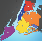
Borough (New York City)
New York City, one of the largest cities in the world, is composed of five boroughs. Each borough now has the same boundaries as the county it is in. County governments were dissolved when the city consolidated in 1898, along with all city, town, and village governments within each county...
, an unusual form of government used to administer the five constituent counties that make up the city. Throughout the boroughs there are hundreds of distinct neighborhoods, many with a definable history and character all their own. If the boroughs were each independent cities, four of the boroughs (Brooklyn, Queens, Manhattan, and the Bronx) would be among the ten most populous cities in the United States.
- The Bronx (Bronx County, pop. 1,364,566) is New York City's northernmost borough. It is the birthplace of rap and hip hop culture, the site of Yankee StadiumYankee StadiumYankee Stadium was a stadium located in The Bronx in New York City, New York. It was the home ballpark of the New York Yankees from 1923 to 1973 and from 1976 to 2008. The stadium hosted 6,581 Yankees regular season home games during its 85-year history. It was also the former home of the New York...
and home to the largest cooperatively owned housing complex in the United States, Co-op CityCo-op City, BronxCo-op City , located in the Baychester section of the Borough of the Bronx in northeast New York City, is one of the largest cooperative housing developments in the world. Situated at the intersection of Interstate 95 and the Hutchinson River Parkway, the community is part of Bronx Community Board 10...
. Except for a small piece of Manhattan known as Marble HillMarble Hill, ManhattanMarble Hill is the neighborhood which makes up the northernmost part of the Borough of Manhattan in New York City, United States. Although it is politically part of Manhattan and New York County, because of the re-routing of the Harlem River, it is located on the North American mainland contiguous...
, the Bronx is the only section of the city that is part of the United States mainland.
- BrooklynBrooklynBrooklyn is the most populous of New York City's five boroughs, with nearly 2.6 million residents, and the second-largest in area. Since 1896, Brooklyn has had the same boundaries as Kings County, which is now the most populous county in New York State and the second-most densely populated...
(Kings County, pop. 2,511,408) is the city's most populous borough and was an independent city until 1898. Brooklyn is known for its cultural diversity, an independent art scene, distinct neighborhoods and a unique architectural heritage. The borough also features a long beachfront and Coney IslandConey IslandConey Island is a peninsula and beach on the Atlantic Ocean in southern Brooklyn, New York, United States. The site was formerly an outer barrier island, but became partially connected to the mainland by landfill....
, famous as one of the earliest amusement grounds in the country.
- ManhattanManhattanManhattan is the oldest and the most densely populated of the five boroughs of New York City. Located primarily on the island of Manhattan at the mouth of the Hudson River, the boundaries of the borough are identical to those of New York County, an original county of the state of New York...
(New York County, pop. 1,606,275) is the most densely populated borough and home to most of the city's skyscrapers. The borough contains the major business centers of the city and many cultural attractions. Manhattan is loosely divided into downtown, midtownMidtown ManhattanMidtown Manhattan, or simply Midtown, is an area of Manhattan, New York City home to world-famous commercial zones such as Rockefeller Center, Broadway, and Times Square...
, and uptownUpper ManhattanUpper Manhattan denotes the more northerly region of the New York City Borough of Manhattan. Its southern boundary may be defined anywhere between 59th Street and 155th Street. Between these two extremes lies the most common definitions of Upper Manhattan as Manhattan above 96th Street...
regions.
- QueensQueensQueens is the easternmost of the five boroughs of New York City. The largest borough in area and the second-largest in population, it is coextensive with Queens County, an administrative division of New York state, in the United States....
(Queens County, pop. 2,256,576) is geographically the largest borough and the most ethnically diverse county in the United States. Historically a collection of small towns and villages founded by the Dutch, the borough today is mainly residential and middle class, with enclaves of above average income and wealth. It is the only large county in the United States where the median income among African-American households, about $52,000 a year, has surpassed that of Caucasian households. Queens is the site of Citi Field and its predecessor Shea StadiumShea StadiumWilliam A. Shea Municipal Stadium, usually shortened to Shea Stadium or just Shea , was a stadium in the New York City borough of Queens, in Flushing Meadows–Corona Park. It was the home baseball park of Major League Baseball's New York Mets from 1964 to 2008...
, the home of the New York MetsNew York MetsThe New York Mets are a professional baseball team based in the borough of Queens in New York City, New York. They belong to Major League Baseball's National League East Division. One of baseball's first expansion teams, the Mets were founded in 1962 to replace New York's departed National League...
, and annually hosts the US Tennis OpenU.S. Open (tennis)The US Open, formally the United States Open Tennis Championships, is a hardcourt tennis tournament which is the modern iteration of one of the oldest tennis championships in the world, the U.S. National Championship, which for men's singles was first contested in 1881...
.
- Staten IslandStaten IslandStaten Island is a borough of New York City, New York, United States, located in the southwest part of the city. Staten Island is separated from New Jersey by the Arthur Kill and the Kill Van Kull, and from the rest of New York by New York Bay...
(Richmond County, pop. 475,014) is the most suburban in character of the five boroughs. It is connected to Brooklyn by the Verrazano-Narrows BridgeVerrazano-Narrows BridgeThe Verrazano-Narrows Bridge is a double-decked suspension bridge that connects the boroughs of Staten Island and Brooklyn in New York City at the Narrows, the reach connecting the relatively protected upper bay with the larger lower bay....
and to Manhattan by the free Staten Island FerryStaten Island FerryThe Staten Island Ferry is a passenger ferry service operated by the New York City Department of Transportation that runs between the boroughs of Manhattan and Staten Island.-Overview:...
. Until 2001 the borough was home to the Fresh Kills LandfillFresh Kills LandfillThe Fresh Kills Landfill was a landfill covering in the New York City borough of Staten Island in the United States. The name comes from the landfill's location along the banks of the Fresh Kills estuary in western Staten Island...
, formerly the largest landfill in the world, which is now being reconstructed as one of the largest urban parks in the United States.
Climate
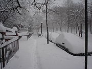
Although it is not in the subtropics and its winters are cold, New York has a humid subtropical climate according to the Köppen climate classification
Köppen climate classification
The Köppen climate classification is one of the most widely used climate classification systems. It was first published by Crimea German climatologist Wladimir Köppen in 1884, with several later modifications by Köppen himself, notably in 1918 and 1936...
because the coldest month's average temperatures are not low enough for persistent snow cover, at 29.5 °F (-1.4 °C) at JFK and 32.1 °F (0.0555555555559977 °C) in Central Park. The region's climate is vastly affected by its proximity to the Atlantic Ocean
Atlantic Ocean
The Atlantic Ocean is the second-largest of the world's oceanic divisions. With a total area of about , it covers approximately 20% of the Earth's surface and about 26% of its water surface area...
. New York City's climate patterns are affected by the Atlantic Multidecadal Oscillation
Atlantic Multidecadal Oscillation
The Atlantic multidecadal oscillation is a mode of variability occurring in the North Atlantic Ocean and which has its principal expression in the sea surface temperature field...
, a 70-year-long warming and cooling cycle in the Atlantic that influences the frequency and severity of hurricanes and coastal storms.
- Winters are typically cold. Temperatures below 0 °F (-17.8 °C) only occur about several times per decade on average, but temperatures of 10–20 °F (-12.2–-6.7 C) are common at the height of typical winters, especially during cold nights. New York winters sometimes feature snowstorms that can paralyze the city with over a foot of snow. However, variation in the climate also occasionally renders winter mild and almost snowless (such as in 1997-98).
- Springs are mild, averaging in the 50s °F (10 to 15 °C) in late March to the lower 80s °F (26-28 °C) in early June. The weather is unpredictable and can even bring relatively cool summers (such as in 1992) as an occasional surprise, and snowstorms arriving as late as the second week in April (significant snow after mid-March is fairly rare though). Thunderstorms are common in spring.
- Summers in New York are hot and humid, with temperatures commonly exceeding 90 °F (32 °C), although high temperatures above 100 °F (38 °C) are about as rare as subzero (F) lows in winter. Humidity levels are usually quite high in July and August. Thunderstorms are common in summer, and produce even the occasional tornadoTornadoA tornado is a violent, dangerous, rotating column of air that is in contact with both the surface of the earth and a cumulonimbus cloud or, in rare cases, the base of a cumulus cloud. They are often referred to as a twister or a cyclone, although the word cyclone is used in meteorology in a wider...
, although severe weather is more common west of the city in New JerseyNew JerseyNew Jersey is a state in the Northeastern and Middle Atlantic regions of the United States. , its population was 8,791,894. It is bordered on the north and east by the state of New York, on the southeast and south by the Atlantic Ocean, on the west by Pennsylvania and on the southwest by Delaware...
because the city's proximity to the ocean usually kills severe thunderstorms before they hit the city. Hurricanes are considered to be a major threat to the area (and especially the Long Island suburbs). While relatively infrequent compared to areas south and east, a direct hit could cause large loss of life and enormous property damage due to the high population in coastal areas.
- Autumns are comfortable in New York and similar to spring in temperature. However, the weather is notably unpredictable and travelers are advised to check forecasts and bring several layers of clothing in late fall and in the early spring months (e.g., November, March, April) as temperatures do fluctuate quickly at these times of year.
- Precipitation is plentiful and averages at 49.7 in (1,262 mm) annually, with spring being the wettest season and February the driest month. Snow averages at 28.1 in (71.4 cm)
- Temperature records have been set as high as 106 °F (41 °C) on July 9, 1936 (in Central ParkCentral ParkCentral Park is a public park in the center of Manhattan in New York City, United States. The park initially opened in 1857, on of city-owned land. In 1858, Frederick Law Olmsted and Calvert Vaux won a design competition to improve and expand the park with a plan they entitled the Greensward Plan...
; LaGuardia AirportLaGuardia AirportLaGuardia Airport is an airport located in the northern part of Queens County on Long Island in the City of New York. The airport is located on the waterfront of Flushing Bay and Bowery Bay, and borders the neighborhoods of Astoria, Jackson Heights and East Elmhurst. The airport was originally...
recorded a 107 °F (42 °C) temperature on July 3, 1966) and as low as -15 °F (-26 °C) on February 9, 1934. These temperatures are not common and have not been matched or surpassed in more than seven decades. Temperatures hit 104 degrees as recently as July 2011 in Central ParkCentral ParkCentral Park is a public park in the center of Manhattan in New York City, United States. The park initially opened in 1857, on of city-owned land. In 1858, Frederick Law Olmsted and Calvert Vaux won a design competition to improve and expand the park with a plan they entitled the Greensward Plan...
and 103 degrees in August 2006 at LaGuardia AirportLaGuardia AirportLaGuardia Airport is an airport located in the northern part of Queens County on Long Island in the City of New York. The airport is located on the waterfront of Flushing Bay and Bowery Bay, and borders the neighborhoods of Astoria, Jackson Heights and East Elmhurst. The airport was originally...
; Central ParkCentral ParkCentral Park is a public park in the center of Manhattan in New York City, United States. The park initially opened in 1857, on of city-owned land. In 1858, Frederick Law Olmsted and Calvert Vaux won a design competition to improve and expand the park with a plan they entitled the Greensward Plan...
dropped to 1 °F as recently as January 2004 (Central Park is cooler than the rest of Manhattan and the boroughs to its south). New York can have excessive days of rain or long stretches of dry weather.
Environmental Issues
New York City
New York is the most populous city in the United States and the center of the New York Metropolitan Area, one of the most populous metropolitan areas in the world. New York exerts a significant impact upon global commerce, finance, media, art, fashion, research, technology, education, and...
plays an important role in the green policy agenda because of its size. Environmental groups make large efforts to help shape legislation in New York because they see the strategy as an efficient way to influence national programs. New York City's economy is larger than Switzerland's, a size that means the city has potential to set new defacto standards. Manufacturers are also attuned to the latest trends and needs in the city because the market is simply too big to ignore.
Although cities like San Francisco or Portland, Oregon
Portland, Oregon
Portland is a city located in the Pacific Northwest, near the confluence of the Willamette and Columbia rivers in the U.S. state of Oregon. As of the 2010 Census, it had a population of 583,776, making it the 29th most populous city in the United States...
are most commonly associated with urban environmentalism in the United States, New York City's unique urban footprint and extensive transportation systems make it more sustainable than most American cities.
See also
- Climate change in New York City
- Geography of New York HarborGeography of New York HarborThe system of waterways of the Port of New York and New Jersey forms one of the most intricate natural harbors in the world, a fact that is reflected in the diversity of place names...
- New York metropolitan areaNew York metropolitan areaThe New York metropolitan area, also known as Greater New York, or the Tri-State area, is the region that composes of New York City and the surrounding region...
- Northeast MegalopolisNortheast megalopolisThe Northeast megalopolis or Boston–Washington megalopolis is the heavily urbanized area of the United States stretching from the the northern suburbs of Boston, Massachusetts to the southern suburbs of Washington, D.C. On a map, the region appears almost as a perfectly straight line. As of 2000,...
- New York City AudubonNew York City AudubonNew York City Audubon is an American non-profit environmental organization incorporated in 1979. The group’s mission reads in part: “New York City Audubon is a grassroots community that works for the protection of wild birds and habitat in the five boroughs, improving the quality of life for all...
External links
- Green Apple Map - Interactive green map of New York City's environmental resources.
- NYC Open Accessible Space Information System - Interactive mapping resource of open space in New York City.
- Council on the Environment of New York City (CENYC) - Privately funded citizens' organization in the Office of the Mayor of New York City.
- NYCityMap - New York City Government interactive map

