
GOES 1
Encyclopedia
GOES 1, designated GOES-A and SMS-C prior to entering service, was a weather satellite
operated by the United States
National Oceanic and Atmospheric Administration
. It was the first Geostationary Operational Environmental Satellite
to be launched.
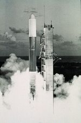
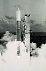 GOES-A was launched atop a Delta 2914
from Launch Complex 17B at the Cape Canaveral Air Force Station
. The launch occurred at 22:40:00 GMT on October 16, 1975, and left the satellite in a geosynchronous transfer orbit. Following launch, it raised itself to a geostationary orbit
by means of its onboard SVM-5 apogee motor, at which time it was redesignated GOES 1.
to gather data for the Global Atmospheric Research Programme
. GOES 1 was equipped with a Visible Infrared Spin Scan Radiometer, or VISSER, which provided day and night imagery of terrestrial cloud conditions. It returned its first image on October 25, 1975, nine days after launch. The satellite continuously monitored weather events and relayed this meteorological data from over 10,000 surface locations into a central processing center. The data was then incorporated into weather prediction models. It also carried a Space Environment Monitor and a Data Collection System, derived from those used on TIROS
satellites.
GOES 1 was replaced by GOES 3
, which was launched in 1978. After finishing operations over the Indian Ocean, it was moved to replace SMS-2 over the Pacific Ocean
. It remained operational there until it was deactivated by NASA on March 7, 1985.
Weather satellite
The weather satellite is a type of satellite that is primarily used to monitor the weather and climate of the Earth. Satellites can be either polar orbiting, seeing the same swath of the Earth every 12 hours, or geostationary, hovering over the same spot on Earth by orbiting over the equator while...
operated by the United States
United States
The United States of America is a federal constitutional republic comprising fifty states and a federal district...
National Oceanic and Atmospheric Administration
National Oceanic and Atmospheric Administration
The National Oceanic and Atmospheric Administration , pronounced , like "noah", is a scientific agency within the United States Department of Commerce focused on the conditions of the oceans and the atmosphere...
. It was the first Geostationary Operational Environmental Satellite
Geostationary Operational Environmental Satellite
The Geostationary Satellite system, operated by the United States National Environmental Satellite, Data, and Information Service , supports weather forecasting, severe storm tracking, and meteorology research. Spacecraft and ground-based elements of the system work together to provide a continuous...
to be launched.
Launch
Delta 2000
The Delta 2000 series was an American expendable launch system which was used to conduct forty-four orbital launches between 1974 and 1981. It was a member of the Delta family of rockets. Several variants existed, which were differentiated by a four digit numerical code.The first stage was an...
from Launch Complex 17B at the Cape Canaveral Air Force Station
Cape Canaveral Air Force Station
Cape Canaveral Air Force Station is an installation of the United States Air Force Space Command's 45th Space Wing, headquartered at nearby Patrick Air Force Base. Located on Cape Canaveral in the state of Florida, CCAFS is the primary launch head of America's Eastern Range with four launch pads...
. The launch occurred at 22:40:00 GMT on October 16, 1975, and left the satellite in a geosynchronous transfer orbit. Following launch, it raised itself to a geostationary orbit
Geostationary orbit
A geostationary orbit is a geosynchronous orbit directly above the Earth's equator , with a period equal to the Earth's rotational period and an orbital eccentricity of approximately zero. An object in a geostationary orbit appears motionless, at a fixed position in the sky, to ground observers...
by means of its onboard SVM-5 apogee motor, at which time it was redesignated GOES 1.
Operations
It was positioned over the Indian OceanIndian Ocean
The Indian Ocean is the third largest of the world's oceanic divisions, covering approximately 20% of the water on the Earth's surface. It is bounded on the north by the Indian Subcontinent and Arabian Peninsula ; on the west by eastern Africa; on the east by Indochina, the Sunda Islands, and...
to gather data for the Global Atmospheric Research Programme
Global Atmospheric Research Programme
The Global Atmospheric Research Programme was a fifteen year international research programme led by the World Meteorological Organization and the International Council of Scientific Unions. It began in 1967 and organised several important field experiments including GARP Atlantic Tropical...
. GOES 1 was equipped with a Visible Infrared Spin Scan Radiometer, or VISSER, which provided day and night imagery of terrestrial cloud conditions. It returned its first image on October 25, 1975, nine days after launch. The satellite continuously monitored weather events and relayed this meteorological data from over 10,000 surface locations into a central processing center. The data was then incorporated into weather prediction models. It also carried a Space Environment Monitor and a Data Collection System, derived from those used on TIROS
TIROS
TIROS, or Television Infrared Observation Satellite, is a series of early weather satellites launched by NASA, beginning with TIROS-1 in 1960. TIROS was the first satellite that was capable of remote sensing of the Earth. This initial remote-sensing effort was significant because it enabled Earth...
satellites.
GOES 1 was replaced by GOES 3
GOES 3
GOES 3, known as GOES-C before becoming operational, is an American geostationary weather and communications satellite. It was originally built for the National Oceanic and Atmospheric Administration as part of the Geostationary Operational Environmental Satellite system, and was launched in June...
, which was launched in 1978. After finishing operations over the Indian Ocean, it was moved to replace SMS-2 over the Pacific Ocean
Pacific Ocean
The Pacific Ocean is the largest of the Earth's oceanic divisions. It extends from the Arctic in the north to the Southern Ocean in the south, bounded by Asia and Australia in the west, and the Americas in the east.At 165.2 million square kilometres in area, this largest division of the World...
. It remained operational there until it was deactivated by NASA on March 7, 1985.