
Fuar Tholl
Encyclopedia
Scottish Highlands
The Highlands is an historic region of Scotland. The area is sometimes referred to as the "Scottish Highlands". It was culturally distinguishable from the Lowlands from the later Middle Ages into the modern period, when Lowland Scots replaced Scottish Gaelic throughout most of the Lowlands...
of Scotland
Scotland
Scotland is a country that is part of the United Kingdom. Occupying the northern third of the island of Great Britain, it shares a border with England to the south and is bounded by the North Sea to the east, the Atlantic Ocean to the north and west, and the North Channel and Irish Sea to the...
. It is situated in the Coulin deer forest 21 km SW of Achnasheen
Achnasheen
Achnasheen is a small village in Ross-shire in the Highland council area of Scotland. Despite the size of the village, Achnasheen is also the name of a postal district which covers several much larger communities. This dates from the time when the village railway station was an important stop on...
in the Wester Ross
Wester Ross
is a western area of Ross and Cromarty in Scotland, notably containing the villages on the west coast such as:* Lochcarron* Applecross* Shieldaig* Torridon* Kinlochewe * * * Aultbea* Laide* Ullapool* Achiltibuie...
region of the Highland
Highland (council area)
Highland is a council area in the Scottish Highlands and is the largest local government area in both Scotland and the United Kingdom as a whole. It shares borders with the council areas of Moray, Aberdeenshire, Perth and Kinross, and Argyll and Bute. Their councils, and those of Angus and...
council area.
Overview
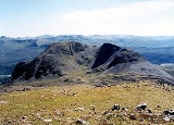
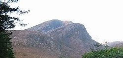
Fuar Tholl has a rocky summit, and has acquired the nickname Wellington's Nose because the summit ridge is similar in profile to an upturned face which bears a supposed likeness to Arthur Wellesley, 1st Duke of WellingtonArthur Wellesley, 1st Duke of Wellington
Field Marshal Arthur Wellesley, 1st Duke of Wellington, KG, GCB, GCH, PC, FRS , was an Irish-born British soldier and statesman, and one of the leading military and political figures of the 19th century...
. The considerable nose on the face is provided the tip of the Mainreachan Buttress which can just be seen over the outline of the main summit. Fuar Tholl reaches a height of 907 metres (2976 feet) making it the 13th highest Corbett. It fails to reach Munro status by just seven metres, but despite this it is regarded by many as the finest of the mountains in the Glen Carron area. The mountain’s name translates from the Gaelic
Scottish Gaelic language
Scottish Gaelic is a Celtic language native to Scotland. A member of the Goidelic branch of the Celtic languages, Scottish Gaelic, like Modern Irish and Manx, developed out of Middle Irish, and thus descends ultimately from Primitive Irish....
language as “Cold Hole”, it was probably named by ancient settlers in Glen Carron and refers to the deep eastern corrie
Cirque
Cirque may refer to:* Cirque, a geological formation* Makhtesh, an erosional landform found in the Negev desert of Israel and Sinai of Egypt*Cirque , an album by Biosphere* Cirque Corporation, a company that makes touchpads...
which is shaded from sunlight and faces that glen.
Geography
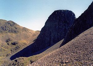
Fuar Tholl’s best feature is the rough stone filled Coire Mainnrichean on the western side of the mountain, which has the spectacular 500 foot high cliffs of the Mainreachan Buttress within it. The buttress is one of the finest ice climbingIce climbing
Ice climbing, as the term indicates, is the activity of ascending inclined ice formations. Usually, ice climbing refers to roped and protected climbing of features such as icefalls, frozen waterfalls, and cliffs and rock slabs covered with ice refrozen from flows of water. For the purposes of...
venues in Scotland with Andy Nisbet having pioneered many of the routes. The one kilometre long summit ridge has three high points, the 907 metre main top is marked by a trig point
Trig point
A triangulation station, also known as a triangulation pillar, trigonometrical station, trigonometrical point, trig station, trig beacon or trig point, and sometimes informally as a trig, is a fixed surveying station, used in geodetic surveying and other surveying projects in its vicinity...
and is situated at the eastern end of the ridge above the eastern corrie which gives the mountain its name. The top of the Mainreachan Buttress is the second top with a height of 895 metres while the third peak is Creag Mainnrichean at the western end of the summit ridge with a height of 857 metres.
Ascents
The hill is close to both the A890 road and the Kyle of Lochalsh railway lineKyle of Lochalsh Line
The Kyle of Lochalsh Line is a primarily single track railway line in the Scottish Highlands, running from Dingwall to Kyle of Lochalsh. The population along the route is sparse in nature, but the scenery is beautiful and can be quite dramatic, the Kyle line having been likened to a symphony in...
. The most common route of ascent starts from Achnashellach
Achnashellach
Achnashellach is an area in Wester Ross in the Highlands of Scotland, and within the Highland council area. It is at the eastern end of Loch Dùghaill, and on the A890 road...
station, initially following the right-of-way
Rights of way in Scotland
In Scotland a right of way is defined as any defined route over which the public has been able to pass unhindered for at least 20 years. The route must link two "public places", such as villages, churches or roads. Unlike in England and Wales there is no obligation on Scottish local authorities to...
to Torridon
Torridon
Torridon is a small village in the Northwest Highlands of Scotland. However the name is also applied to the area surrounding the village, particularly the Torridon Hills, mountains to the north of Glen Torridon. It lies on the shore of Loch Torridon.Torridon is on the west coast of Scotland, ...
. After about 2 kilometres another path leads off to the left, heading for the bealach
Mountain pass
A mountain pass is a route through a mountain range or over a ridge. If following the lowest possible route, a pass is locally the highest point on that route...
between Fuar Tholl and Sgorr Ruadh
Sgorr Ruadh
Sgorr Ruadh is a mountain situated in the mountainous area between Strath Carron and Glen Torridon in Wester Ross in the Highland Region of Scotland...
. From here the summit may be reached by way of a steep and somewhat loose path. There are a number of other possible routes from the south; they are usually utilised for descent, allowing a circular route to be undertaken
Fuar Tholl may also be climbed as part of a circuit of Corrie Lair, taking in two Munro
Munro
A Munro is a mountain in Scotland with a height over . They are named after Sir Hugh Munro, 4th Baronet , who produced the first list of such hills, known as Munros Tables, in 1891. A Munro top is a summit over 3,000 ft which is not regarded as a separate mountain...
s: Sgorr Ruadh and Beinn Liath Mhòr
Beinn Liath Mhòr
Beinn Liath Mhòr is a Scottish mountain situated in the mountainous area between Strath Carron and Glen Torridon in Wester Ross in the Highland region. Geologically Beinn Liath Mhòr is made up of Cambrian quartzite scree and Torridonian sandstones giving the mountain a distinctive colour contrast...
.