
Beinn Liath Mhòr
Encyclopedia
Beinn Liath Mhòr is a Scottish
mountain situated in the mountainous area between Strath Carron and Glen Torridon
in Wester Ross
in the Highland region
. Geologically Beinn Liath Mhòr is made up of Cambrian
quartzite
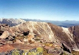
scree
and Torridonian sandstones giving the mountain a distinctive colour contrast of light and dark. The mountain's other main characteristic is its two kilometre long undulating summit ridge which does not drop below 800 metres for its entire length. This culminates at the summit at its far western end at a height of 926 metres (3038 feet) making Beinn Liath Mhòr the 258th highest Munro
.
on the A890 road and goes by the right of way
to Glen Torridon. This follows the impressive Coire Lair, a rugged valley surrounded by three imposing mountains, the other two being Sgorr Ruadh
(which is also a Munro) and Fuar Tholl
which is ranked as one of the finest Corbetts
by mountain writers. The Coire Lair path is followed for two kilometres until the path forks, here the right hand fork is taken across moorland for 0.5 kilometre until reaching the steep climb of Beinn Liath Mhòr’s south east ridge, which leads directly to the summit plateau. The summit ridge consists of light coloured quartzite
stones, whilst the highest point at the far end is crowned by a quartzite cairn
. It is also possible to climb Beinn Liath Mhòr from Glen Torridon starting at the car park at grid reference and following the Ling path to its termination and then ascending the mountain by its western ridge.
The prospect from the summit gives splendid views of the Torridon mountains
to the west including a unique side on view of Liathach
and its pinnacles, there are many small lochans well seen below the mountain, as is Upper Loch Torridon
. Many walkers will continue from Beinn Liath Mhòr to take in the accompanying Munro of Sgorr Ruadh and strong walkers will also take in Fuar Tholl giving a top class high level walk around Coire Lair.
Scotland
Scotland is a country that is part of the United Kingdom. Occupying the northern third of the island of Great Britain, it shares a border with England to the south and is bounded by the North Sea to the east, the Atlantic Ocean to the north and west, and the North Channel and Irish Sea to the...
mountain situated in the mountainous area between Strath Carron and Glen Torridon
Torridon Hills
The Torridon Hills surround Torridon village in the Northwest Highlands of Scotland. The name is usually applied to the mountains to the north of Glen Torridon...
in Wester Ross
Wester Ross
is a western area of Ross and Cromarty in Scotland, notably containing the villages on the west coast such as:* Lochcarron* Applecross* Shieldaig* Torridon* Kinlochewe * * * Aultbea* Laide* Ullapool* Achiltibuie...
in the Highland region
Highland (council area)
Highland is a council area in the Scottish Highlands and is the largest local government area in both Scotland and the United Kingdom as a whole. It shares borders with the council areas of Moray, Aberdeenshire, Perth and Kinross, and Argyll and Bute. Their councils, and those of Angus and...
. Geologically Beinn Liath Mhòr is made up of Cambrian
Cambrian
The Cambrian is the first geological period of the Paleozoic Era, lasting from Mya ; it is succeeded by the Ordovician. Its subdivisions, and indeed its base, are somewhat in flux. The period was established by Adam Sedgwick, who named it after Cambria, the Latin name for Wales, where Britain's...
quartzite
Quartzite
Quartzite is a hard metamorphic rock which was originally sandstone. Sandstone is converted into quartzite through heating and pressure usually related to tectonic compression within orogenic belts. Pure quartzite is usually white to gray, though quartzites often occur in various shades of pink...
scree
Scree
Scree, also called talus, is a term given to an accumulation of broken rock fragments at the base of crags, mountain cliffs, or valley shoulders. Landforms associated with these materials are sometimes called scree slopes or talus piles...
and Torridonian sandstones giving the mountain a distinctive colour contrast of light and dark. The mountain's other main characteristic is its two kilometre long undulating summit ridge which does not drop below 800 metres for its entire length. This culminates at the summit at its far western end at a height of 926 metres (3038 feet) making Beinn Liath Mhòr the 258th highest Munro
Munro
A Munro is a mountain in Scotland with a height over . They are named after Sir Hugh Munro, 4th Baronet , who produced the first list of such hills, known as Munros Tables, in 1891. A Munro top is a summit over 3,000 ft which is not regarded as a separate mountain...
.
Ascent
The most common approach to Beinn Liath Mhòr starts at AchnashellachAchnashellach
Achnashellach is an area in Wester Ross in the Highlands of Scotland, and within the Highland council area. It is at the eastern end of Loch Dùghaill, and on the A890 road...
on the A890 road and goes by the right of way
Rights of way in Scotland
In Scotland a right of way is defined as any defined route over which the public has been able to pass unhindered for at least 20 years. The route must link two "public places", such as villages, churches or roads. Unlike in England and Wales there is no obligation on Scottish local authorities to...
to Glen Torridon. This follows the impressive Coire Lair, a rugged valley surrounded by three imposing mountains, the other two being Sgorr Ruadh
Sgorr Ruadh
Sgorr Ruadh is a mountain situated in the mountainous area between Strath Carron and Glen Torridon in Wester Ross in the Highland Region of Scotland...
(which is also a Munro) and Fuar Tholl
Fuar Tholl
Fuar Tholl is a mountain in the highlands of Scotland. It is situated in the Coulin deer forest 21 km SW of Achnasheen in the Wester Ross region of the Highland council area.-Overview:...
which is ranked as one of the finest Corbetts
Hill lists in the British Isles
The mountains and hills of Great Britain, and to a lesser extent Ireland, are the subject of a considerable number of lists that categorise them by height, topographic prominence, or other criteria. They are commonly used as a basis for peak bagging, whereby hillwalkers attempt to reach all the...
by mountain writers. The Coire Lair path is followed for two kilometres until the path forks, here the right hand fork is taken across moorland for 0.5 kilometre until reaching the steep climb of Beinn Liath Mhòr’s south east ridge, which leads directly to the summit plateau. The summit ridge consists of light coloured quartzite
Quartzite
Quartzite is a hard metamorphic rock which was originally sandstone. Sandstone is converted into quartzite through heating and pressure usually related to tectonic compression within orogenic belts. Pure quartzite is usually white to gray, though quartzites often occur in various shades of pink...
stones, whilst the highest point at the far end is crowned by a quartzite cairn
Cairn
Cairn is a term used mainly in the English-speaking world for a man-made pile of stones. It comes from the or . Cairns are found all over the world in uplands, on moorland, on mountaintops, near waterways and on sea cliffs, and also in barren desert and tundra areas...
. It is also possible to climb Beinn Liath Mhòr from Glen Torridon starting at the car park at grid reference and following the Ling path to its termination and then ascending the mountain by its western ridge.
The prospect from the summit gives splendid views of the Torridon mountains
Torridon Hills
The Torridon Hills surround Torridon village in the Northwest Highlands of Scotland. The name is usually applied to the mountains to the north of Glen Torridon...
to the west including a unique side on view of Liathach
Liathach
Liathach is one of the most famous of the Torridon Hills. It lies to the north of the A896 road, in the Northwest Highlands of Scotland, and has two peaks of Munro status: Spidean a' Choire Leith at the east of the main ridge, and Mullach an Rathain at the western end of the mountain...
and its pinnacles, there are many small lochans well seen below the mountain, as is Upper Loch Torridon
Loch Torridon
Loch Torridon is a sea loch on the west coast of Scotland in the Northwest Highlands. The loch was created by glacial processes and is in total around 15 miles long. It has two sections: Upper Loch Torridon to landward, east of Rubha na h-Airde Ghlaise, at which point it joins Loch Sheildaig;...
. Many walkers will continue from Beinn Liath Mhòr to take in the accompanying Munro of Sgorr Ruadh and strong walkers will also take in Fuar Tholl giving a top class high level walk around Coire Lair.