
Fowlers Bay, South Australia
Encyclopedia
Fowlers Bay, formerly Yalata, is a small coastal town in South Australia
, located approximately 912 kilometres (567 mi) north west of the state capital, Adelaide
. Situated on the Nullarbor Plain
, it was once an active port and a gateway to the western reaches of the continent, but fell into decline in the 1960s. At the 2006 census
, Fowlers Bay and the surrounding area had a population of 125.
, a Dutch sea captain. His ship was the Golden Seahorse (Gulden Zeepard). Fowlers Bay was named by Matthew Flinders
when he anchored his ship The Investigator in the waters on 28 January 1802, after his first lieutenant, Robert Fowler.
Edward John Eyre
set up base camp here in 1840 during his epic journeys across the Nullarbor Plain
. By this time the area was well-known to American and French whaling
ships; Eyre documents seeing whalers in the area.
In the 1860s, the first pastoral leases were established by William Swan and Robert Barr-Smith, forming Yalata station, a massive farming property, whose boundaries encompassed from the Head of the Great Australian Bight
to Streaky Bay.
The region was surveyed
in March 1890 and proclaimed a town (under the name Yalata) in the Government Gazette in 1890, with the name changed to Fowler's Bay in 1940. Yalata now refers to a nearby township.
(only 15% of the state is under Local Government). The town does not receive reticulated power or water. It is currently a popular overnight destination between Nundroo and Penong, and its good fishing facilities, attractive beaches and surrounding historical ruins gives the town some interest for tourists and sightseers. There are no sealed roads to Fowlers Bay and visitors should seek advice before driving across the saltwater bog behind the town.
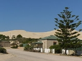
Visually the town is dominated by a large sand dune
that protects the town from the Southern Ocean
.
The ruins of the homestead of the Yalata station can be found several kilometres from the town. There is a small cemetery on the outskirts of the town.
South Australia
South Australia is a state of Australia in the southern central part of the country. It covers some of the most arid parts of the continent; with a total land area of , it is the fourth largest of Australia's six states and two territories.South Australia shares borders with all of the mainland...
, located approximately 912 kilometres (567 mi) north west of the state capital, Adelaide
Adelaide
Adelaide is the capital city of South Australia and the fifth-largest city in Australia. Adelaide has an estimated population of more than 1.2 million...
. Situated on the Nullarbor Plain
Nullarbor Plain
The Nullarbor Plain is part of the area of flat, almost treeless, arid or semi-arid country of southern Australia, located on the Great Australian Bight coast with the Great Victoria Desert to its north. It is the world's largest single piece of limestone, and occupies an area of about...
, it was once an active port and a gateway to the western reaches of the continent, but fell into decline in the 1960s. At the 2006 census
Census in Australia
The Australian census is administered once every five years by the Australian Bureau of Statistics. The most recent census was conducted on 9 August 2011; the next will be conducted in 2016. Prior to the introduction of regular censuses in 1961, they had also been run in 1901, 1911, 1921, 1933,...
, Fowlers Bay and the surrounding area had a population of 125.
History
The coastline around Fowlers Bay was first mapped in 1627 by François ThijssenFrançois Thijssen
François Thijssen or Frans Thijsz was a Dutch explorer who explored the southern coast of Australia.He was the captain of the ship t Gulden Zeepaerdt when sailing from Cape of Good Hope to Batavia...
, a Dutch sea captain. His ship was the Golden Seahorse (Gulden Zeepard). Fowlers Bay was named by Matthew Flinders
Matthew Flinders
Captain Matthew Flinders RN was one of the most successful navigators and cartographers of his age. In a career that spanned just over twenty years, he sailed with Captain William Bligh, circumnavigated Australia and encouraged the use of that name for the continent, which had previously been...
when he anchored his ship The Investigator in the waters on 28 January 1802, after his first lieutenant, Robert Fowler.
Edward John Eyre
Edward John Eyre
Edward John Eyre was an English land explorer of the Australian continent, colonial administrator, and a controversial Governor of Jamaica....
set up base camp here in 1840 during his epic journeys across the Nullarbor Plain
Nullarbor Plain
The Nullarbor Plain is part of the area of flat, almost treeless, arid or semi-arid country of southern Australia, located on the Great Australian Bight coast with the Great Victoria Desert to its north. It is the world's largest single piece of limestone, and occupies an area of about...
. By this time the area was well-known to American and French whaling
Whaling
Whaling is the hunting of whales mainly for meat and oil. Its earliest forms date to at least 3000 BC. Various coastal communities have long histories of sustenance whaling and harvesting beached whales...
ships; Eyre documents seeing whalers in the area.
In the 1860s, the first pastoral leases were established by William Swan and Robert Barr-Smith, forming Yalata station, a massive farming property, whose boundaries encompassed from the Head of the Great Australian Bight
Great Australian Bight
The Great Australian Bight is a large bight, or open bay, off the central and western portions of the southern coastline of mainland Australia.-Extent:...
to Streaky Bay.
The region was surveyed
Surveying
See Also: Public Land Survey SystemSurveying or land surveying is the technique, profession, and science of accurately determining the terrestrial or three-dimensional position of points and the distances and angles between them...
in March 1890 and proclaimed a town (under the name Yalata) in the Government Gazette in 1890, with the name changed to Fowler's Bay in 1940. Yalata now refers to a nearby township.
In the 2000s
Today Fowlers Bay is located in the unincorporated area of South AustraliaOutback Areas Community Development Trust
The Outback Areas Community Development Trust is a trust in South Australia which is operated under the Outback Areas Community Development Trust Act...
(only 15% of the state is under Local Government). The town does not receive reticulated power or water. It is currently a popular overnight destination between Nundroo and Penong, and its good fishing facilities, attractive beaches and surrounding historical ruins gives the town some interest for tourists and sightseers. There are no sealed roads to Fowlers Bay and visitors should seek advice before driving across the saltwater bog behind the town.
Visually the town is dominated by a large sand dune
Dune
In physical geography, a dune is a hill of sand built by wind. Dunes occur in different forms and sizes, formed by interaction with the wind. Most kinds of dunes are longer on the windward side where the sand is pushed up the dune and have a shorter "slip face" in the lee of the wind...
that protects the town from the Southern Ocean
Southern Ocean
The Southern Ocean comprises the southernmost waters of the World Ocean, generally taken to be south of 60°S latitude and encircling Antarctica. It is usually regarded as the fourth-largest of the five principal oceanic divisions...
.
The ruins of the homestead of the Yalata station can be found several kilometres from the town. There is a small cemetery on the outskirts of the town.