

Four Corners (Canada)
Encyclopedia
Canada
Canada is a North American country consisting of ten provinces and three territories. Located in the northern part of the continent, it extends from the Atlantic Ocean in the east to the Pacific Ocean in the west, and northward into the Arctic Ocean...
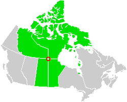
is a point near 60°00′00"N 102°00′00"W where four political subdivisions almost meet. These are the provinces of Manitoba
Manitoba
Manitoba is a Canadian prairie province with an area of . The province has over 110,000 lakes and has a largely continental climate because of its flat topography. Agriculture, mostly concentrated in the fertile southern and western parts of the province, is vital to the province's economy; other...
and Saskatchewan
Saskatchewan
Saskatchewan is a prairie province in Canada, which has an area of . Saskatchewan is bordered on the west by Alberta, on the north by the Northwest Territories, on the east by Manitoba, and on the south by the U.S. states of Montana and North Dakota....
and the territories of the Northwest Territories
Northwest Territories
The Northwest Territories is a federal territory of Canada.Located in northern Canada, the territory borders Canada's two other territories, Yukon to the west and Nunavut to the east, and three provinces: British Columbia to the southwest, and Alberta and Saskatchewan to the south...
and Nunavut
Nunavut
Nunavut is the largest and newest federal territory of Canada; it was separated officially from the Northwest Territories on April 1, 1999, via the Nunavut Act and the Nunavut Land Claims Agreement Act, though the actual boundaries had been established in 1993...
.
The point is located near the southern shore of Kasba Lake
Kasba Lake
Kasba Lake is a lake in the northern Canadian wilderness. The majority of the lake lies within the Northwest Territories but a small section is in Nunavut.-See also:*Kasba Lake Airport*Kasba Lake Water Aerodrome*List of lakes in the Northwest Territories...
. It is in remote northern wilderness, hundreds of kilometres from any road, railway, or airport. The point is marked by a metre-high aluminium obelisk. The obelisk was erected in 1962 to mark the intersection of the boundaries of Manitoba and Saskatchewan.
In the legal definition of Nunavut, its border is specified as "Commencing at the intersection of 60°00'N
60th parallel north
The 60th parallel north is a circle of latitude that is 60 degrees north of the Earth's equatorial plane. It crosses Europe, Asia, the Pacific Ocean, North America, and the Atlantic Ocean....
latitude
Latitude
In geography, the latitude of a location on the Earth is the angular distance of that location south or north of the Equator. The latitude is an angle, and is usually measured in degrees . The equator has a latitude of 0°, the North pole has a latitude of 90° north , and the South pole has a...
with 102°00'W
102nd meridian west
The meridian 102° west of Greenwich is a line of longitude that extends from the North Pole across the Arctic Ocean, North America, the Pacific Ocean, the Southern Ocean, and Antarctica to the South Pole....
longitude
Longitude
Longitude is a geographic coordinate that specifies the east-west position of a point on the Earth's surface. It is an angular measurement, usually expressed in degrees, minutes and seconds, and denoted by the Greek letter lambda ....
, being the intersection of the Manitoba, Northwest Territories and Saskatchewan borders". The pre-existing boundary of Saskatchewan and Manitoba as surveyed does not fall precisely on the meridian of 102°W
102nd meridian west
The meridian 102° west of Greenwich is a line of longitude that extends from the North Pole across the Arctic Ocean, North America, the Pacific Ocean, the Southern Ocean, and Antarctica to the South Pole....
.