
Fortrose, New Zealand
Encyclopedia
South Island
The South Island is the larger of the two major islands of New Zealand, the other being the more populous North Island. It is bordered to the north by Cook Strait, to the west by the Tasman Sea, to the south and east by the Pacific Ocean...
of New Zealand
New Zealand
New Zealand is an island country in the south-western Pacific Ocean comprising two main landmasses and numerous smaller islands. The country is situated some east of Australia across the Tasman Sea, and roughly south of the Pacific island nations of New Caledonia, Fiji, and Tonga...
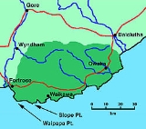
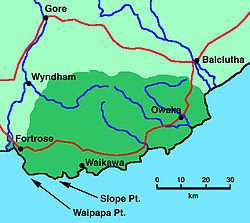
in the Southland region. It is situated on Toetoes Bay
Toetoes Bay
Toetoes Bay is the easternmost of three large bays lying on the Foveaux Strait coast of Southland, New Zealand, the others being Te Waewae Bay and Oreti Beach. Thirty kilometres in length, the bay is the southern end of the Awarua Plain, an area of swampy land stretching inland for about fifteen...
at the mouth of the Mataura River
Mataura River
The Mataura River is in the Southland Region of the South Island of New Zealand. It is 190 kilometres in length.The river's headwaters are located in mountains to the south of Lake Wakatipu. From there it flows southeast towards Gore, where it turns southward...
, and is on the far western edge of the Catlins
The Catlins
The Catlins comprises an area in the southeastern corner of the South Island of New Zealand. The area lies between Balclutha and Invercargill, straddling the boundary between the Otago and Southland regions...
. Nearby settlements include Otara to the southeast, Pukewao
Pukewao
Pukewao is a locality in the southeastern corner of the Southland region of New Zealand's South Island. It is located inland from Toetoes Bay in the very western part of the Catlins, and nearby settlements include Tokanui to the southeast, Fortrose on the coast to the southwest, and Te Peka and...
and Tokanui
Tokanui
Tokanui is a community in the eastern portion of Southland District Council, located on the Southern Scenic Route about 55 km east of Invercargill and 109 km southwest of Balclutha, New Zealand....
to the northeast, and Titiroa
Titiroa
Titiroa is a locality in the Southland Region of New Zealand's South Island. It is on the eastern bank of the lower Mataura River, inland from Toetoes Bay...
and Waimahaka
Waimahaka
Waimahaka is a locality in the Southland region of New Zealand's South Island. It is situated in a rural area, inland from Toetoes Bay. Nearby settlements include Pine Bush and Titiroa to the northwest, Fortification and Te Peka to the east, Pukewao and Tokanui to the southwest, and Fortrose on...
to the north.
History
From 1834 to 1836, whalers lived at a station in the Fortrose area, and the first surveys for a town - slightly to the west of Fortrose's present location - gave it the name of Russelltown. In the mid-19th century, Fortrose acquired its current name, a tribute to FortroseFortrose
Fortrose is a burgh in the Scottish Highlands, located on the Moray Firth, approximately ten kilometres north east of Inverness. The town is known for its ruined 13th century cathedral, and as the home of the Brahan Seer. In the Middle Ages it was the seat of the bishopric of Ross...
in Scotland
Scotland
Scotland is a country that is part of the United Kingdom. Occupying the northern third of the island of Great Britain, it shares a border with England to the south and is bounded by the North Sea to the east, the Atlantic Ocean to the north and west, and the North Channel and Irish Sea to the...
, from a Scottish drover
Droving
Droving is the practice of moving livestock over large distances by walking them "on the hoof".Droving stock to market, usually on foot and often with the aid of dogs, has a very long history in the old world...
. Its location at the Mataura's mouth meant it developed as a port to service the local region, and in 1875, a 200 feet (61 m) long jetty was built. However, Fortrose's economy declined after the Tokanui Branch
Tokanui Branch
The Tokanui Branch, also known as the Seaward Bush Branch, was a branch line railway located in Southland, New Zealand. It diverged from the Bluff Branch south of the main railway station in Invercargill and ran for 54 kilometres in a southeasterly direction...
railway was opened to Waimahaka in 1899 and then Tokanui in 1911, as the railway provided much quicker transportation for freight to Invercargill
Invercargill
Invercargill is the southernmost and westernmost city in New Zealand, and one of the southernmost cities in the world. It is the commercial centre of the Southland region. It lies in the heart of the wide expanse of the Southland Plains on the Oreti or New River some 18 km north of Bluff,...
.
A number of Fortrose residents fought overseas in World War I
World War I
World War I , which was predominantly called the World War or the Great War from its occurrence until 1939, and the First World War or World War I thereafter, was a major war centred in Europe that began on 28 July 1914 and lasted until 11 November 1918...
and World War II
World War II
World War II, or the Second World War , was a global conflict lasting from 1939 to 1945, involving most of the world's nations—including all of the great powers—eventually forming two opposing military alliances: the Allies and the Axis...
. Six were killed in the former and two in the latter. A round obelisk stands in Fortrose as a memorial to the deceased; it was unveiled in 1922 in honour of the World War I victims, with the names of the World War II casualties added later.
Economy
In the 19th century, goods such as grain, logs, and wool were significant in the local economy. After its early 20th century decline, it is now reviving somewhat as 'The Gateway to the CatlinsThe Catlins
The Catlins comprises an area in the southeastern corner of the South Island of New Zealand. The area lies between Balclutha and Invercargill, straddling the boundary between the Otago and Southland regions...
'.