
.gif)
Fort Rock (Oregon)
Encyclopedia
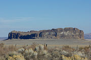
Fort Rock is a volcanic landmark called a tuff ring, located on an ice age
lake bed in north Lake County
, Oregon
, United States
.
The ring is about 4460 foot in diameter and stands about 200 foot high above the surrounding plain. Its tall, straight sides resemble the palisade
s of a fort, thus giving the rock its name. The region of Fort Rock Basin
contains about 40 such tuff rings and maar
s and is located in the Brothers Fault Zone of central Oregon
's Great Basin
. On June 20, 1925, the Bend Bulletin
wrote that Fort Rock was named by William Sullivan, an early resident.
magma
rose to the surface and encountered the wet muds of a lake bottom. Powered by a jet of steam, molten basalt was blown into the air, creating a fountain of hot lava
particles and frothy ash
. The pieces and blobs of hot lava and ash rained down around the vent and formed a saucer-shaped ring of lapilli
tuff
and volcanic ash
sitting like an island in the lake waters. Steam explosions also loosened angular chunks of black and red lava rock comprising the valley floor. These are thought to be similar to if not continuous with Picture Gorge Basalt flows of the John Day
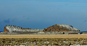
country. These blocky inclusions are incorporated into the fine-grained tuff layers at Fort Rock. Waves from the lake waters eroded the outside of the ring, cutting the steep cliffs into terraces 66 foot above the floor of Fort Rock Valley.
The wave-cut terraces on the south side of the ring mark former lake levels of this now-dry lakebed. Southerly winds, which are still predominant in this region, apparently drove waves against the south side of the ring, eroding the soft ash layers, breaching it, and creating a large opening on the south side.
 Previous age estimates of Fort Rock ranged upwards to 1.8 million years. Recently, the age of Fort Rock has been estimated at 50,000 to 100,000 years. This coincides with a period of time when large pluvial
lakes filled the valleys of central Oregon and much of the Great Basin of the western United States. At its maximum, the water in Fort Rock Lake was estimated to cover nearly 900 square miles (2,331 km²) and was about 150 feet (45.7 m) deep where the Fort Rock tuff ring formed.
The extensive terrace on the side of Fort Rock marks one lakeshore about 14,000 years ago. Even higher water levels are recorded on the tuff cliffs and at one point only the tops of the tuff ring were exposed as rocky islands in this inland sea. An age of about 21,000 years ago has been found for this highest lake level.
(formerly Fort Rock State Park)
Camping is not permitted. There is day-use with hiking trails, interpretive signs, restrooms and picnic tables. A seasonal park host is on site to answer questions.
, where in 1936 Dr. Luther Cressman
from the University of Oregon
discovered sagebrush
sandals and human artifacts dated approximately 9,000 to 10,000 years ago.
Entry to the cave is by prearranged tour only. Contact Oregon State Parks using their website.
Hole-in-the-Ground
and Big Hole
are two nearby maars nearly one mile in diameter formed by steam explosion. They resemble impact crater
s formed by meteorites, but lack the heavy metal signature residues of space objects.
Crack in the Ground
and Fossil Lake
are two more nearby Ice Age
geological features.
South Ice Cave is a lava tube with easy access. Derrick's Cave is estimated to be 1200 feet (365.8 m) long, perhaps Oregon's third-longest lava tube cave. Both are accessible on public BLM and Forest Service land near Fort Rock. Devil's Garden Lava Field and East Lava Field are other geological oddities northeast of Fort Rock a few miles. Inflated lava, kīpuka
, and lava ponds are found here, plus both ʻaʻā and pāhoehoe flows.
Fort Rock Valley Historical Homestead Museum
and the small community of Fort Rock
are one mile south of Fort Rock State Natural Area. The open air museum
consists of an office/interpretive center/gift shop and a collection of historic buildings from north Lake County.
They offer tours Friday, Saturday, and Sunday from Memorial Day to Labor Day. School groups and families can tour other days by pre-arrangement. Contact info is on the park website.
Ice age
An ice age or, more precisely, glacial age, is a generic geological period of long-term reduction in the temperature of the Earth's surface and atmosphere, resulting in the presence or expansion of continental ice sheets, polar ice sheets and alpine glaciers...
lake bed in north Lake County
Lake County, Oregon
Lake County is a county in the high desert south central region of the U.S. state of Oregon, so named for the many lakes found within its boundaries, including Lake Abert, Hart Lake Reservoir, and Goose Lake. While Lake is among Oregon's largest counties, it is sparsely populated with 7,895...
, Oregon
Oregon
Oregon is a state in the Pacific Northwest region of the United States. It is located on the Pacific coast, with Washington to the north, California to the south, Nevada on the southeast and Idaho to the east. The Columbia and Snake rivers delineate much of Oregon's northern and eastern...
, United States
United States
The United States of America is a federal constitutional republic comprising fifty states and a federal district...
.
The ring is about 4460 foot in diameter and stands about 200 foot high above the surrounding plain. Its tall, straight sides resemble the palisade
Palisade
A palisade is a steel or wooden fence or wall of variable height, usually used as a defensive structure.- Typical construction :Typical construction consisted of small or mid sized tree trunks aligned vertically, with no spacing in between. The trunks were sharpened or pointed at the top, and were...
s of a fort, thus giving the rock its name. The region of Fort Rock Basin
Fort Rock Basin
Portions of this article include public domain text from the USFS .The Fort Rock-Christmas Lake Valley Basin is the basin of a former inland sea that existed in that region from Pliocene through late Pleistocene time....
contains about 40 such tuff rings and maar
Maar
A maar is a broad, low-relief volcanic crater that is caused by a phreatomagmatic eruption, an explosion caused by groundwater coming into contact with hot lava or magma. A maar characteristically fills with water to form a relatively shallow crater lake. The name comes from the local Moselle...
s and is located in the Brothers Fault Zone of central Oregon
Central Oregon
Central Oregon is a geographic region in the U.S. state of Oregon and is traditionally considered to be made up of Deschutes, Jefferson, and Crook counties. Other definitions include larger areas, often encompassing areas to the north towards the Columbia River, eastward towards Burns, or south...
's Great Basin
Great Basin
The Great Basin is the largest area of contiguous endorheic watersheds in North America and is noted for its arid conditions and Basin and Range topography that varies from the North American low point at Badwater Basin to the highest point of the contiguous United States, less than away at the...
. On June 20, 1925, the Bend Bulletin
The Bulletin (Bend)
The Bulletin is the daily newspaper of Bend, Oregon, United States. The Bulletin is owned by Western Communications, a family-owned corporation founded by editor Robert W. Chandler. WesCom owns nine publications in Oregon and California.-History:...
wrote that Fort Rock was named by William Sullivan, an early resident.
Geology
Fort Rock was created when basaltBasalt
Basalt is a common extrusive volcanic rock. It is usually grey to black and fine-grained due to rapid cooling of lava at the surface of a planet. It may be porphyritic containing larger crystals in a fine matrix, or vesicular, or frothy scoria. Unweathered basalt is black or grey...
magma
Magma
Magma is a mixture of molten rock, volatiles and solids that is found beneath the surface of the Earth, and is expected to exist on other terrestrial planets. Besides molten rock, magma may also contain suspended crystals and dissolved gas and sometimes also gas bubbles. Magma often collects in...
rose to the surface and encountered the wet muds of a lake bottom. Powered by a jet of steam, molten basalt was blown into the air, creating a fountain of hot lava
Lava
Lava refers both to molten rock expelled by a volcano during an eruption and the resulting rock after solidification and cooling. This molten rock is formed in the interior of some planets, including Earth, and some of their satellites. When first erupted from a volcanic vent, lava is a liquid at...
particles and frothy ash
Volcanic ash
Volcanic ash consists of small tephra, which are bits of pulverized rock and glass created by volcanic eruptions, less than in diameter. There are three mechanisms of volcanic ash formation: gas release under decompression causing magmatic eruptions; thermal contraction from chilling on contact...
. The pieces and blobs of hot lava and ash rained down around the vent and formed a saucer-shaped ring of lapilli
Lapilli
Lapilli is a size classification term for tephra, which is material that falls out of the air during a volcanic eruption or during some meteorite impacts. Lapilli means "little stones" in Latin. They are in some senses similar to ooids or pisoids in calcareous sediments.By definition lapilli range...
tuff
Tuff
Tuff is a type of rock consisting of consolidated volcanic ash ejected from vents during a volcanic eruption. Tuff is sometimes called tufa, particularly when used as construction material, although tufa also refers to a quite different rock. Rock that contains greater than 50% tuff is considered...
and volcanic ash
Volcanic ash
Volcanic ash consists of small tephra, which are bits of pulverized rock and glass created by volcanic eruptions, less than in diameter. There are three mechanisms of volcanic ash formation: gas release under decompression causing magmatic eruptions; thermal contraction from chilling on contact...
sitting like an island in the lake waters. Steam explosions also loosened angular chunks of black and red lava rock comprising the valley floor. These are thought to be similar to if not continuous with Picture Gorge Basalt flows of the John Day
John Day, Oregon
John Day is a city located about north of Canyon City in Grant County, Oregon, at the intersection of U.S. Routes 26 and 395. The city was named for the nearby John Day River, which had been named for a Virginian member of the 1811 Astor Expedition, John Day...
country. These blocky inclusions are incorporated into the fine-grained tuff layers at Fort Rock. Waves from the lake waters eroded the outside of the ring, cutting the steep cliffs into terraces 66 foot above the floor of Fort Rock Valley.
The wave-cut terraces on the south side of the ring mark former lake levels of this now-dry lakebed. Southerly winds, which are still predominant in this region, apparently drove waves against the south side of the ring, eroding the soft ash layers, breaching it, and creating a large opening on the south side.
Age estimates
Pluvial
In geology and climatology, a pluvial was an extended period of abundant rainfall lasting many thousands of years. Pluvial is also applied to the sediments of these periods . The term is especially applied to such periods during the Pleistocene Epoch...
lakes filled the valleys of central Oregon and much of the Great Basin of the western United States. At its maximum, the water in Fort Rock Lake was estimated to cover nearly 900 square miles (2,331 km²) and was about 150 feet (45.7 m) deep where the Fort Rock tuff ring formed.
The extensive terrace on the side of Fort Rock marks one lakeshore about 14,000 years ago. Even higher water levels are recorded on the tuff cliffs and at one point only the tops of the tuff ring were exposed as rocky islands in this inland sea. An age of about 21,000 years ago has been found for this highest lake level.
Fort Rock State Natural Area
Fort Rock is designated as Fort Rock State Natural Area.(formerly Fort Rock State Park)
Camping is not permitted. There is day-use with hiking trails, interpretive signs, restrooms and picnic tables. A seasonal park host is on site to answer questions.
Other geological features
A nearby tuff ring has a water-formed cave, called Fort Rock CaveFort Rock Cave
Fort Rock Cave was the site of the earliest evidence of human habitation in the U.S. state of Oregon prior to excavation of Paisley Caves. Fort Rock Cave featured numerous well-preserved sagebrush sandals, ranging from 9,000 to 13,000 years old....
, where in 1936 Dr. Luther Cressman
Luther Cressman
Luther Sheeleigh Cressman was an American anthropologist. He is known as the father of Oregon anthropology....
from the University of Oregon
University of Oregon
-Colleges and schools:The University of Oregon is organized into eight schools and colleges—six professional schools and colleges, an Arts and Sciences College and an Honors College.- School of Architecture and Allied Arts :...
discovered sagebrush
Artemisia tridentata
Artemisia tridentata is a shrub or small tree from the family Asteraceae. Some botanists treat it in the segregate genus Seriphidium, as S. tridentatum W. A. Weber, but this is not widely followed...
sandals and human artifacts dated approximately 9,000 to 10,000 years ago.
Entry to the cave is by prearranged tour only. Contact Oregon State Parks using their website.
Hole-in-the-Ground
Hole-in-the-Ground
Hole-in-the-Ground is a large maar in the Fort Rock Basin of Lake County, central Oregon, northeast of Crater Lake, near Oregon Route 31....
and Big Hole
Big Hole (Oregon)
Big Hole is a large maar in the Fort Rock Basin of Lake County, central Oregon, northeast of Crater Lake, near Oregon Route 31. It is approximately 6000 ft across and deep....
are two nearby maars nearly one mile in diameter formed by steam explosion. They resemble impact crater
Impact crater
In the broadest sense, the term impact crater can be applied to any depression, natural or manmade, resulting from the high velocity impact of a projectile with a larger body...
s formed by meteorites, but lack the heavy metal signature residues of space objects.
Crack in the Ground
Crack in the Ground
Crack in the Ground is a volcanic fissure over two miles long and up to 70 feet deep in central Oregon, US.The eruptions from the Four Craters Lava Field were accompanied by a slight sinking of the older rock surface, forming a shallow, graben-like structure about 3 kilometers wide and extending...
and Fossil Lake
are two more nearby Ice Age
Ice age
An ice age or, more precisely, glacial age, is a generic geological period of long-term reduction in the temperature of the Earth's surface and atmosphere, resulting in the presence or expansion of continental ice sheets, polar ice sheets and alpine glaciers...
geological features.
South Ice Cave is a lava tube with easy access. Derrick's Cave is estimated to be 1200 feet (365.8 m) long, perhaps Oregon's third-longest lava tube cave. Both are accessible on public BLM and Forest Service land near Fort Rock. Devil's Garden Lava Field and East Lava Field are other geological oddities northeast of Fort Rock a few miles. Inflated lava, kīpuka
Kipuka
A kīpuka is an area of land completely surrounded by one or more younger lava flows. A kīpuka forms when lava flows on either side of a hill, ridge, or older lava dome as it moves downslope or spreads from its source. Older and more weathered than their surroundings, kīpukas often appear to be like...
, and lava ponds are found here, plus both ʻaʻā and pāhoehoe flows.
Fort Rock Valley Historical Homestead Museum
Fort Rock Valley Historical Homestead Museum
The Fort Rock Valley Historical Homestead Museum is located in Fort Rock, Oregon, United States. Opened in 1988, it is a collection of original pioneer buildings including a church, school, houses, homestead cabins, and several other buildings assembled in a village setting. The structures were...
and the small community of Fort Rock
Fort Rock, Oregon
Fort Rock is an unincorporated community in Lake County, Oregon, United States, southeast of Fort Rock State Natural Area.The community of Fort Rock was named after the natural feature Fort Rock by the town's founder, Ray Nash. Fort Rock post office was established in 1908 under postmaster Josiah...
are one mile south of Fort Rock State Natural Area. The open air museum
Open air museum
An open-air museum is a distinct type of museum exhibiting its collections out-of-doors. The first open-air museums were established in Scandinavia towards the end of the nineteenth century, and the concept soon spread throughout Europe and North America. Open-air museums are variously known as...
consists of an office/interpretive center/gift shop and a collection of historic buildings from north Lake County.
They offer tours Friday, Saturday, and Sunday from Memorial Day to Labor Day. School groups and families can tour other days by pre-arrangement. Contact info is on the park website.