
Fort Greely, Alaska
Encyclopedia
Census-designated place
A census-designated place is a concentration of population identified by the United States Census Bureau for statistical purposes. CDPs are delineated for each decennial census as the statistical counterparts of incorporated places such as cities, towns and villages...
(CDP) in Southeast Fairbanks Census Area
Southeast Fairbanks Census Area, Alaska
Southeast Fairbanks Census Area is a census area located in the state of Alaska, United States. As of the 2000 census, the population was 6,174. It is part of the unorganized borough and therefore has no borough seat...
, Alaska
Alaska
Alaska is the largest state in the United States by area. It is situated in the northwest extremity of the North American continent, with Canada to the east, the Arctic Ocean to the north, and the Pacific Ocean to the west and south, with Russia further west across the Bering Strait...
, United States
United States
The United States of America is a federal constitutional republic comprising fifty states and a federal district...
. It is home to the Fort Greely
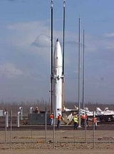
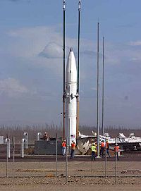
Fort Greely
Fort Greely is a United States Army launch site for anti-ballistic missiles located approximately 100 miles southeast of Fairbanks, Alaska. It is also the home of the Cold Regions Test Center , as Fort Greely is one of the coldest areas in Alaska, and can accommodate cold, extreme cold, or...
military installation. At the 2000 census the population was 461.
Geography
Fort Greely is located at 63°58′2"N 145°42′33"W (63.905016, -145.554566). Fort Greely is located 5 miles (8 km) south of Delta JunctionDelta Junction, Alaska
Delta Junction is a city in the Southeast Fairbanks Census Area, Alaska, United States. According to 2005 Census Bureau estimates, the population of the city is 897. The city is located a short distance south of the confluence of the Delta River with the Tanana River, which is at Big Delta...
on the Richardson Highway
Richardson Highway
The Richardson Highway is a highway in the U.S. state of Alaska, running 368 miles from Valdez to Fairbanks. It is marked as Alaska Route 4 from Valdez to Delta Junction and as Alaska Route 2 from there to Fairbanks. It is also connects segments of Alaska Route 1 between the Glenn Highway and the...
. According to the United States Census Bureau
United States Census Bureau
The United States Census Bureau is the government agency that is responsible for the United States Census. It also gathers other national demographic and economic data...
, the CDP has a total area of 169.7 square miles (439.5 km²). 169.4 square miles (438.7 km²) of it is land and 0.4 square miles (1 km²) of it (0.21%) is water.
Demographics
As of the censusCensus
A census is the procedure of systematically acquiring and recording information about the members of a given population. It is a regularly occurring and official count of a particular population. The term is used mostly in connection with national population and housing censuses; other common...
of 2000, there were 461 people, 126 households, and 112 families residing in the CDP. The population density
Population density
Population density is a measurement of population per unit area or unit volume. It is frequently applied to living organisms, and particularly to humans...
was 2.7/sq mi (1.1/km²). There were 354 housing units at an average density of 2.1/sq mi (0.8/km²). The racial makeup of the CDP was 65.73% White
Race (United States Census)
Race and ethnicity in the United States Census, as defined by the Federal Office of Management and Budget and the United States Census Bureau, are self-identification data items in which residents choose the race or races with which they most closely identify, and indicate whether or not they are...
, 19.74% Black
Race (United States Census)
Race and ethnicity in the United States Census, as defined by the Federal Office of Management and Budget and the United States Census Bureau, are self-identification data items in which residents choose the race or races with which they most closely identify, and indicate whether or not they are...
or African American
Race (United States Census)
Race and ethnicity in the United States Census, as defined by the Federal Office of Management and Budget and the United States Census Bureau, are self-identification data items in which residents choose the race or races with which they most closely identify, and indicate whether or not they are...
, 1.30% Native American
Race (United States Census)
Race and ethnicity in the United States Census, as defined by the Federal Office of Management and Budget and the United States Census Bureau, are self-identification data items in which residents choose the race or races with which they most closely identify, and indicate whether or not they are...
, 1.30% Asian
Race (United States Census)
Race and ethnicity in the United States Census, as defined by the Federal Office of Management and Budget and the United States Census Bureau, are self-identification data items in which residents choose the race or races with which they most closely identify, and indicate whether or not they are...
, 1.95% Pacific Islander
Race (United States Census)
Race and ethnicity in the United States Census, as defined by the Federal Office of Management and Budget and the United States Census Bureau, are self-identification data items in which residents choose the race or races with which they most closely identify, and indicate whether or not they are...
, 3.69% from other races
Race (United States Census)
Race and ethnicity in the United States Census, as defined by the Federal Office of Management and Budget and the United States Census Bureau, are self-identification data items in which residents choose the race or races with which they most closely identify, and indicate whether or not they are...
, and 6.29% from two or more races. 15.40% of the population were Hispanic
Race (United States Census)
Race and ethnicity in the United States Census, as defined by the Federal Office of Management and Budget and the United States Census Bureau, are self-identification data items in which residents choose the race or races with which they most closely identify, and indicate whether or not they are...
or Latino
Race (United States Census)
Race and ethnicity in the United States Census, as defined by the Federal Office of Management and Budget and the United States Census Bureau, are self-identification data items in which residents choose the race or races with which they most closely identify, and indicate whether or not they are...
of any race.
There were 126 households out of which 73.8% had children under the age of 18 living with them, 80.2% were married couples
Marriage
Marriage is a social union or legal contract between people that creates kinship. It is an institution in which interpersonal relationships, usually intimate and sexual, are acknowledged in a variety of ways, depending on the culture or subculture in which it is found...
living together, 7.1% had a female householder with no husband present, and 11.1% were non-families. 11.1% of all households were made up of individuals and none had someone living alone who was 65 years of age or older. The average household size was 3.25 and the average family size was 3.53.
In the CDP the population was spread out with 38.6% under the age of 18, 16.1% from 18 to 24, 43.4% from 25 to 44, 2.0% from 45 to 64, . The median age was 23 years. For every 100 females there were 115.4 males. For every 100 females age 18 and over, there were 119.4 males.
The median income for a household in the CDP was $33,750, and the median income for a family was $32,969. Males had a median income of $26,544 versus $21,375 for females. The per capita income
Per capita income
Per capita income or income per person is a measure of mean income within an economic aggregate, such as a country or city. It is calculated by taking a measure of all sources of income in the aggregate and dividing it by the total population...
for the CDP was $12,368. About 11.6% of families and 10.4% of the population were below the poverty line, including 10.9% of those under age 18 and none of those age 65 or over.
Climate
As it is not near the ocean, this area is drier than coastal Alaska and experiences seasonal extremes typical of subarctic areas. The annual precipitation is only 12 inches (305 mm), including 37 inches (94 cm) of snow. The average low temperature in January is −11 °F (−23 °C). The average high during July is +69 °F (+20 °C). Temperature extremes have been recorded from −63 °F to +92 °F (−53 °C to +33 °C).Fort Greely is mostly sunny in the summer and split between clear and overcast days in the winter. On clear winter nights, the aurora borealis can often be seen dancing in the sky. Like all subarctic regions, the months from May to July in the summer have no night, only a twilight during the night hours. The months of November to January have little daylight.
Sources and references
- "Fort Greely". Encyclopedia Astronautica. Retrieved Jul. 18, 2006.
External links
- Fort Greely Homepage (official site)
- U.S. Army Cold Regions Test Center