
Form based codes
Encyclopedia
A form-based code (FBC) is a means of regulating development to achieve a specific urban form. Form-based codes create a predictable public realm by controlling physical form primarily, with a lesser focus on land use
, through city or county regulations.
Form-based codes are a new response to the modern challenges of urban sprawl, deterioration of historic neighborhoods, and neglect of pedestrian safety in new development. Tradition has declined as a guide to development patterns, and the widespread adoption by cities of single-use zoning
regulations has discouraged compact, walkable urbanism. Form-based codes are a tool to address these deficiencies, and to provide local governments the regulatory means to achieve development objectives with greater certainty.
's focus on the micromanagement and segregation of land uses, and the control of development intensity through abstract and uncoordinated parameters (e.g., floor area ratio
s, dwelling units per acre, setback
s, parking ratios) to the neglect of an integrated built form. Not to be confused with design guidelines or general statements of policy, form-based codes are regulatory, not advisory.
Form-based codes are drafted to achieve a community vision based on time-tested forms of urbanism. Ultimately, a form-based code is a tool; the quality of development outcomes is dependent on the quality and objectives of the community plan that a code implements.
, the planning of cities in ancient China, and Roman town planning. The Laws of the Indies
, promulgated by the Spanish Crown starting in the 16th century, established some basic urban form requirements for colonial towns in the Americas. William Penn
when planning Philadelphia in the 17th century did not shy from precise urban form requirements when he said, "Let every house be in a line, or upon a line, as much as may be."
During the 18th century, Baroque urban design
commonly brought buildings to the fronts of their lots with common facade treatments. Baron Haussmann
, appointed by Napoleon III to oversee the redevelopment of Paris in the 19th century, stipulated precise ratios of building heights to street widths; disposition and sizes of windows and doors on building facades; consistent planting of street trees; and standardization of material colors to bring unity and harmony to the public environment.
The development of modern form-based codes was started by architects, urban designers, and physical planners frustrated by the ineffectiveness of past criticisms of sprawl development and the failure of critics to propose realistic alternatives. These professionals, used to thinking physically about community problems, began the search for systematic physical solutions in the 1970s. Architect Christopher Alexander
published A Pattern Language in 1977, a compendium of physical rules for designing humane buildings and places. Ian McHarg
developed systematic mapping tools to encourage deliberate development patterns sensitive to local environmental conditions. Traditional Neighborhood Development ordinances were drafted beginning in the early 1990s as sets of development regulations to promote traditional neighborhood forms in new development projects. TND ordinances were typically adopted as an optional regulatory procedure that developers could request in place of conventional zoning . But their design regulations were not mapped to parcels or streets in advance, so lacked predictability of outcomes; TND ordinances proved to be an instructive effort, but showed few results.
Meanwhile, the accelerating scale of worldwide urban growth and the rapid expansion of the extent of cities heightened the need for regulatory tools better equipped to deal with such growth. The first serious attempt at creating a modern form-based code was done in 1982 to guide the development of the Florida resort town of Seaside
by the husband and wife design team of Andres Duany
and Elizabeth Plater-Zyberk
. Realizing that designing an entire town would be an overwhelming task and would in the end lack the visual serendipity that only comes from myriad creative minds at work, they created a design code that established basic physical standards mapped to parcels, and then invited developers and architects to put their own distinctive stamp on their projects—but operating within those standards. The Seaside Code proved very successful; the resulting development of the town of Seaside is widely recognized as one of the most important and appealing planning efforts of the post-World War II era.
Duany/Plater-Zyberk's codes and the work of subsequent form-based code practitioners are not top-down mandates from imperial designers as in the baroque era or the wishful thinking of design guidelines that lack enforceability, but are instead legal regulations adopted by units of local government. As regulations they possess police power
; violators of the regulations can be cited, and their invocation or retraction must go through a legislative process. As such, the community plays a more forceful role in shaping its physical future.

-based code that can be calibrated for local needs—the SMARTCODE
. Its first attempted customization was done for Vicksburg, Mississippi in 2001 (Mouzon & Greene). The lessons learned there led to the first California adoption of a citywide form-based code for the City of Sonoma in March 2003 (Crawford Multari & Clark Associates, Moule & Polyzoides), followed on June 16, 2003, by the first SmartCode adopted in the U.S., for central Petaluma, California (Fisher and Hall Urban Design, Crawford Multari & Clark Associates). SmartCodes are now being calibrated for Miami, Florida and Hurricane Katrina ravaged communities in Mississippi and Louisiana, along with cities as diverse as Taos, NM, Michigan City, IN, Jamestown, RI, Lawrence, KS, New Castle, DE, and Bran, Romania. Planetary climate change that must be mitigated by changes in the human environment will no doubt be an inducement to form-based and transect-based coding in the future.
Because of the growing number of consultants advertising themselves as capable of writing FBCs but with little or no training, in 2004 the non-profit Form-Based Codes Institute was organized to establish standards and teach best practices. In addition, SmartCode workshops are regularly scheduled by PlaceMakers.com, SmartCodePro.com, and SmartCodeLocal.com.
Form-based codes also sometimes include:
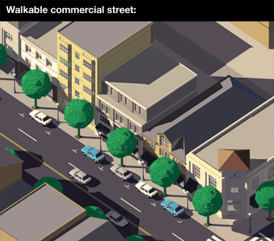 The types of buildings that make for a lively main street are different from the types of buildings that make for a quiet residential street. Building Form Standards are sets of enforceable design regulations for controlling building types and how they impact the public realm. These Standards are mapped to streets on a Regulating Plan. Building Form Standards can control such things as: the alignment of buildings to the street; how close buildings are to sidewalks; the visibility and accessibility of building entrances; minimum and maximum buildings heights; minimum or maximum lot frontage coverage; minimum and maximum amounts of window coverage on facades; physical elements required on buildings (e.g. stoops, porches, types of permitted balconies); and the general usage of floors (e.g. office, residential, or retail). These regulations are less concerned with architectural styles and designs than in how buildings shape public spaces. If a local government also wishes to regulate the quality of architecture--for example to preserve the historic appearance of a neighborhood--then Architectural Standards should be drafted in addition to Building Form Standards.
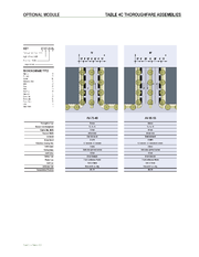 Public Space Standards control the physical form of squares, parks, the public right-of-way of streets, and other public spaces. Public spaces are typically under the control of public works, parks, and highway departments. Streets, being the most common public spaces in a community, are the most frequently regulated. Public Space Standards for streets are typically described with dimensioned cross-sections and/or plan views showing travel lane widths, sidewalk widths, street tree and street lamp placement, locations of transit lanes, and the placement of architecture. Plan view diagrams may also be included showing spacing of street trees and lamps, and the radii of the curves of street corners.
Mandatory codes. This is the most common adoption approach. It has the most regulatory "teeth"—compliance is required. But it is the most ambitious of the approaches, making the new code a seamless part of, or a complete replacement for, the existing zoning ordinance. The form-based code can be adopted as a new zoning district or as an overlay district.
Unique to California and a few other states with appropriate enabling legislation, form-based codes can be contained within a planning document called a "specific plan," which can completely override the zoning ordinance for a given geographic area. Since it stands apart from the zoning ordinance, it can be more creative in its format, giving the coder greater freedom in designing for user-friendliness through page layout, diagrams, and illustrations. Also, the urban design plan and the implementing regulations are bundled together, greatly improving user comprehension. But since the specific plan is not securely integrated within the existing zoning ordinance, it may be more politically vulnerable to retraction.
Example adopted codes:
Optional (parallel) codes. An optional or parallel form-based code serves as an alternative to, but doesn't replace, a present zoning ordinance. Compliance is voluntary. The developer has the choice of complying with the form-based code or the zoning ordinance, but it must be one or the other. This approach makes sense when compliance with the zoning ordinance is so difficult and time consuming that most development is stymied. Thus a developer has the option of following a form-based code that will streamline and simplify his development process. But, for a local government to maintain two different sets of development regulations for one area is added work which can be significant if the area is extensive. Also depending on the area being regulated, if some developers are choosing the form-based code and others nearby are not, the possibilities for integrated place-making can be compromised.
Example codes:
Floating-zone codes. Floating zones are most often written to facilitate master-planned suburban communities and are called PUDs (planned unit developments). However, floating-zone codes are now being written as form-based codes to facilitate urban development. A floating-zone form-based code does not contain a regulating plan but includes instructions and standards for developers to follow when they prepare a regulating plan for their property (e.g. maximum block dimensions, street types, building types, open space accessibility, sidewalk widths.) This distinguishes floating-zone codes from the other two approaches–developers rather than the local government create the regulating plans and the urban designs that they facilitate, but the local government sets the standards. Floating-zone codes allow local governments to establish urban form standards for development without incurring the expense of developing urban design and regulating plans. Developers are given the freedom, within clear parameters, to prepare regulating plans for their property that are likely to meet government approval. A developer submits his or her regulating plan for approval through the rezoning process. Upon rezoning, the floating zone replaces the prior zoning for that property and the regulating plan becomes binding.
Example codes:
Initially a local government may wish to adopt a form-based code for its entire jurisdiction following one approach, but find this too ambitious with short-term resource and political limitations requiring a more focused effort. Instead it may wish to follow one approach for a smaller area, and then phase in other areas using the same or different approaches as needed. Or a floating-zone code could be adopted for large areas awaiting the public resources coming later that would allow the local government to draft its own regulating plans. Whatever approach is followed—or combination of approaches—simplicity and consistency helps at the permit desk where the code is implemented.
Land use
Land use is the human use of land. Land use involves the management and modification of natural environment or wilderness into built environment such as fields, pastures, and settlements. It has also been defined as "the arrangements, activities and inputs people undertake in a certain land cover...
, through city or county regulations.
Form-based codes are a new response to the modern challenges of urban sprawl, deterioration of historic neighborhoods, and neglect of pedestrian safety in new development. Tradition has declined as a guide to development patterns, and the widespread adoption by cities of single-use zoning
Zoning
Zoning is a device of land use planning used by local governments in most developed countries. The word is derived from the practice of designating permitted uses of land based on mapped zones which separate one set of land uses from another...
regulations has discouraged compact, walkable urbanism. Form-based codes are a tool to address these deficiencies, and to provide local governments the regulatory means to achieve development objectives with greater certainty.
Scope
Form-based codes address the relationship between building facades and the public realm, the form and mass of buildings in relation to one another, and the scale and types of streets and blocks. The regulations and standards in form-based codes, presented in both diagrams and words, are keyed to a regulating plan that designates the appropriate form and scale (and therefore, character) of development rather than only distinctions in land-use types. This is in contrast to conventional zoningZoning
Zoning is a device of land use planning used by local governments in most developed countries. The word is derived from the practice of designating permitted uses of land based on mapped zones which separate one set of land uses from another...
's focus on the micromanagement and segregation of land uses, and the control of development intensity through abstract and uncoordinated parameters (e.g., floor area ratio
Floor Area Ratio
The floor area ratio or floor space index is the ratio of the total floor area of buildings on a certain location to the size of the land of that location, or the limit imposed on such a ratio....
s, dwelling units per acre, setback
Setback
Setback may have the following meanings:* Setback , the distance a structure must be from the edge of a lot* Setback , making upper storeys of a high-rise building further back than the lower ones for aesthetic, structural, or land-use restriction reasons* Pitch , a card game related to All Fours*A...
s, parking ratios) to the neglect of an integrated built form. Not to be confused with design guidelines or general statements of policy, form-based codes are regulatory, not advisory.
Form-based codes are drafted to achieve a community vision based on time-tested forms of urbanism. Ultimately, a form-based code is a tool; the quality of development outcomes is dependent on the quality and objectives of the community plan that a code implements.
History
Form-based codes are part of a long history of shaping the built landscape for public benefit. Such efforts go back to the urban designs of Hippodamus of MiletusHippodamus of Miletus
Hippodamus of Miletos was an ancient Greek architect, urban planner, physician, mathematician, meteorologist and philosopher and is considered to be the “father” of urban planning, the namesake of Hippodamian plan of city layouts...
, the planning of cities in ancient China, and Roman town planning. The Laws of the Indies
Laws of the Indies
The Laws of the Indies are the entire body of laws issued by the Spanish Crown for its American and Philippine possessions of its empire. They regulated social, political and economic life in these areas...
, promulgated by the Spanish Crown starting in the 16th century, established some basic urban form requirements for colonial towns in the Americas. William Penn
William Penn
William Penn was an English real estate entrepreneur, philosopher, and founder of the Province of Pennsylvania, the English North American colony and the future Commonwealth of Pennsylvania. He was an early champion of democracy and religious freedom, notable for his good relations and successful...
when planning Philadelphia in the 17th century did not shy from precise urban form requirements when he said, "Let every house be in a line, or upon a line, as much as may be."
During the 18th century, Baroque urban design
Urban design
Urban design concerns the arrangement, appearance and functionality of towns and cities, and in particular the shaping and uses of urban public space. It has traditionally been regarded as a disciplinary subset of urban planning, landscape architecture, or architecture and in more recent times has...
commonly brought buildings to the fronts of their lots with common facade treatments. Baron Haussmann
Baron Haussmann
Georges-Eugène Haussmann, commonly known as Baron Haussmann , was a French civic planner whose name is associated with the rebuilding of Paris...
, appointed by Napoleon III to oversee the redevelopment of Paris in the 19th century, stipulated precise ratios of building heights to street widths; disposition and sizes of windows and doors on building facades; consistent planting of street trees; and standardization of material colors to bring unity and harmony to the public environment.
Emergence
Regulating urban form is a challenge in modern democracies. Design guidelines adopted by municipalities, without legal enforceability, often invite capricious observance, thus failing to produce the comprehensive changes required to produce satisfying public places. When public planning exercises fail to produce predictable results, citizens often rebel against any development. In addition, from early in the twentieth century to the present, attempts at regulating the built landscape have usually been done for reasons that neglect community form, that are more concerned with the uses of property and impacts of scale than the form that development takes. And a planning profession that in recent decades has focused on policy, neglecting design, encouraged an abstract intellectual response to problems that are largely physical in nature.The development of modern form-based codes was started by architects, urban designers, and physical planners frustrated by the ineffectiveness of past criticisms of sprawl development and the failure of critics to propose realistic alternatives. These professionals, used to thinking physically about community problems, began the search for systematic physical solutions in the 1970s. Architect Christopher Alexander
Christopher Alexander
Christopher Wolfgang Alexander is a registered architect noted for his theories about design, and for more than 200 building projects in California, Japan, Mexico and around the world...
published A Pattern Language in 1977, a compendium of physical rules for designing humane buildings and places. Ian McHarg
Ian McHarg
Ian L. McHarg was born in Clydebank, Scotland and became a landscape architect and a renowned writer on regional planning using natural systems. He was the founder of the department of landscape architecture at the University of Pennsylvania in the United States. His 1969 book Design with Nature...
developed systematic mapping tools to encourage deliberate development patterns sensitive to local environmental conditions. Traditional Neighborhood Development ordinances were drafted beginning in the early 1990s as sets of development regulations to promote traditional neighborhood forms in new development projects. TND ordinances were typically adopted as an optional regulatory procedure that developers could request in place of conventional zoning . But their design regulations were not mapped to parcels or streets in advance, so lacked predictability of outcomes; TND ordinances proved to be an instructive effort, but showed few results.
Meanwhile, the accelerating scale of worldwide urban growth and the rapid expansion of the extent of cities heightened the need for regulatory tools better equipped to deal with such growth. The first serious attempt at creating a modern form-based code was done in 1982 to guide the development of the Florida resort town of Seaside
Seaside, Florida
Seaside is an unincorporated master-planned community on the Florida panhandle in Walton County, between Panama City Beach and Destin. The town has become the topic of slide lectures in architectural schools and in housing-industry magazines, and is visited by design professionals from all over the...
by the husband and wife design team of Andres Duany
Andrés Duany
Andrés Duany is an American architect and urban planner.Duany was born in New York City but grew up in Cuba until 1960. He attended The Choate School and received his undergraduate degree in architecture and urban planning from Princeton University...
and Elizabeth Plater-Zyberk
Elizabeth Plater-Zyberk
Elizabeth Plater-Zyberk is an American architect and urban planner of Polish aristocratic roots based in Miami, Florida...
. Realizing that designing an entire town would be an overwhelming task and would in the end lack the visual serendipity that only comes from myriad creative minds at work, they created a design code that established basic physical standards mapped to parcels, and then invited developers and architects to put their own distinctive stamp on their projects—but operating within those standards. The Seaside Code proved very successful; the resulting development of the town of Seaside is widely recognized as one of the most important and appealing planning efforts of the post-World War II era.
Duany/Plater-Zyberk's codes and the work of subsequent form-based code practitioners are not top-down mandates from imperial designers as in the baroque era or the wishful thinking of design guidelines that lack enforceability, but are instead legal regulations adopted by units of local government. As regulations they possess police power
Police power
In United States constitutional law, police power is the capacity of the states to regulate behavior and enforce order within their territory for the betterment of the general welfare, morals, health, and safety of their inhabitants...
; violators of the regulations can be cited, and their invocation or retraction must go through a legislative process. As such, the community plays a more forceful role in shaping its physical future.
Recent developments
Although the Seaside code was commissioned by a private developer, most current codes are commissioned by counties and municipalities. Since Seaside, the scale of form-based coding projects has grown. Form-based coding can be applied at many scales, from a two-block main street to a county-wide region. An early form-based code was adopted for downtown West Palm Beach in 1995. A significant code for a major urban arterial, the Columbia Pike in Arlington County, Virginia, was adopted in 2003 (Ferrell Madden Associates). A regional FBC was adopted in 2006 by St. Lucie County, Florida (Spikowski Associates, Dover-Kohl Partners). Duany/Plater-Zyberk has drafted a model FBC that is also a transectTransect (urban)
The urban-to-rural transect is an urban planning model created by New Urbanist Andrés Duany. The transect defines a series of zones that transition from sparse rural farmhouses to the dense urban core. Each zone is fractal in that it contains a similar transition from the edge to the center of the...
-based code that can be calibrated for local needs—the SMARTCODE
SMARTCODE
SmartCode is a unified land development ordinance template for planning and urban design. Originally developed by Duany Plater-Zyberk & Company, this open source program is a model form-based unified land development ordinance designed to create walkable neighborhoods across the full spectrum of...
. Its first attempted customization was done for Vicksburg, Mississippi in 2001 (Mouzon & Greene). The lessons learned there led to the first California adoption of a citywide form-based code for the City of Sonoma in March 2003 (Crawford Multari & Clark Associates, Moule & Polyzoides), followed on June 16, 2003, by the first SmartCode adopted in the U.S., for central Petaluma, California (Fisher and Hall Urban Design, Crawford Multari & Clark Associates). SmartCodes are now being calibrated for Miami, Florida and Hurricane Katrina ravaged communities in Mississippi and Louisiana, along with cities as diverse as Taos, NM, Michigan City, IN, Jamestown, RI, Lawrence, KS, New Castle, DE, and Bran, Romania. Planetary climate change that must be mitigated by changes in the human environment will no doubt be an inducement to form-based and transect-based coding in the future.
Because of the growing number of consultants advertising themselves as capable of writing FBCs but with little or no training, in 2004 the non-profit Form-Based Codes Institute was organized to establish standards and teach best practices. In addition, SmartCode workshops are regularly scheduled by PlaceMakers.com, SmartCodePro.com, and SmartCodeLocal.com.
Components
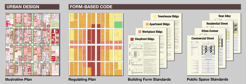
Form-based codes commonly include the following elements:- Regulating Plan. A plan or map of the regulated area designating the locations where different building form standards apply, based on clear community intentions regarding the physical character of the area being coded.
- Public Space Standards. Specifications for the elements within the public realm (e.g., sidewalks, travel lanes, on-street parking, street trees, street furniture, etc.).
- Building Form Standards. Regulations controlling the configuration, features, and functions of buildings that define and shape the public realm.
- Administration. A clearly defined application and project review process.
- Definitions. A glossary to ensure the precise use of technical terms.
Form-based codes also sometimes include:
- Architectural Standards. Regulations controlling external architectural materials and quality.
- Landscaping Standards. Regulations controlling landscape design and plant materials on private property as they impact public spaces (e.g. regulations about parking lot screening and shading, maintaining sight lines, insuring unobstructed pedestrian movements, etc.).
- Signage Standards. Regulations controlling allowable signage sizes, materials, illumination, and placement.
- Environmental Resource Standards. Regulations controlling issues such as storm water drainage and infiltration, development on slopes, tree protection, solar access, etc.
- Annotation. Text and illustrations explaining the intentions of specific code provisions.
Building Form Standards
Public Space Standards
Identification
How does one determine if a development regulation is a form-based code and a well-crafted one? Form-based codes generally receive affirmative answers to all of the following questions:- Is the code's focus primarily on regulating urban form and less on land use?
- Is the code regulatory rather than advisory?
- Does the code emphasize standards and parameters for form with predictable physical outcomes (build-to lines, frontage type requirements, etc.) rather than relying on numerical parameters (floor-area ratios, density, etc.) whose outcomes are impossible to predict?
- Does the code require private buildings to shape public space through the use of building form standards with specific requirements for building placement?
- Does the code promote and/or conserve an interconnected street network and pedestrian-scaled blocks?
- Are regulations and standards keyed to specific locations on a regulating plan?
- Are the diagrams in the code unambiguous, clearly labeled, and accurate in their presentation of spatial configurations?
Implementation
How are form-based codes incorporated into a local government's development regulations? There are three basic ways:Mandatory codes. This is the most common adoption approach. It has the most regulatory "teeth"—compliance is required. But it is the most ambitious of the approaches, making the new code a seamless part of, or a complete replacement for, the existing zoning ordinance. The form-based code can be adopted as a new zoning district or as an overlay district.
Unique to California and a few other states with appropriate enabling legislation, form-based codes can be contained within a planning document called a "specific plan," which can completely override the zoning ordinance for a given geographic area. Since it stands apart from the zoning ordinance, it can be more creative in its format, giving the coder greater freedom in designing for user-friendliness through page layout, diagrams, and illustrations. Also, the urban design plan and the implementing regulations are bundled together, greatly improving user comprehension. But since the specific plan is not securely integrated within the existing zoning ordinance, it may be more politically vulnerable to retraction.
Example adopted codes:
- Winter Springs Town Center District Code, Winter Springs, Florida
- Farmers Branch Station Area Form-Based Code, Farmers Branch, Texas
- Central Petaluma Specific Plan and SmartCode, Petaluma, California
Optional (parallel) codes. An optional or parallel form-based code serves as an alternative to, but doesn't replace, a present zoning ordinance. Compliance is voluntary. The developer has the choice of complying with the form-based code or the zoning ordinance, but it must be one or the other. This approach makes sense when compliance with the zoning ordinance is so difficult and time consuming that most development is stymied. Thus a developer has the option of following a form-based code that will streamline and simplify his development process. But, for a local government to maintain two different sets of development regulations for one area is added work which can be significant if the area is extensive. Also depending on the area being regulated, if some developers are choosing the form-based code and others nearby are not, the possibilities for integrated place-making can be compromised.
Example codes:
- Columbia Pike Form-Based Code, Arlington County, Virginia
- Pike Road SmartCode, Pike Road, Alabama
- Pass Christian SmartCode, Pass Christian, Mississippi
Floating-zone codes. Floating zones are most often written to facilitate master-planned suburban communities and are called PUDs (planned unit developments). However, floating-zone codes are now being written as form-based codes to facilitate urban development. A floating-zone form-based code does not contain a regulating plan but includes instructions and standards for developers to follow when they prepare a regulating plan for their property (e.g. maximum block dimensions, street types, building types, open space accessibility, sidewalk widths.) This distinguishes floating-zone codes from the other two approaches–developers rather than the local government create the regulating plans and the urban designs that they facilitate, but the local government sets the standards. Floating-zone codes allow local governments to establish urban form standards for development without incurring the expense of developing urban design and regulating plans. Developers are given the freedom, within clear parameters, to prepare regulating plans for their property that are likely to meet government approval. A developer submits his or her regulating plan for approval through the rezoning process. Upon rezoning, the floating zone replaces the prior zoning for that property and the regulating plan becomes binding.
Example codes:
- Miami/Dade County TND District, Dade County, Florida
- Towns, Villages, Countryside Land Development Regulations, St. Lucie County, Florida
- Flowood SmartCode, Flowood, Mississippi
- Montgomery SmartCode, Montgomery, Alabama (not to be confused with the mandatory SmartCode for downtown)
Initially a local government may wish to adopt a form-based code for its entire jurisdiction following one approach, but find this too ambitious with short-term resource and political limitations requiring a more focused effort. Instead it may wish to follow one approach for a smaller area, and then phase in other areas using the same or different approaches as needed. Or a floating-zone code could be adopted for large areas awaiting the public resources coming later that would allow the local government to draft its own regulating plans. Whatever approach is followed—or combination of approaches—simplicity and consistency helps at the permit desk where the code is implemented.
See also
- Zoning in the United StatesZoning in the United StatesZoning in the United States comprise land use state laws falling under the police power rights that State governments and local governments have the authority to exercise over privately owned real property.-Origins and history:...
- Development control in the United Kingdom
- Statutory planningStatutory planningUrban planning is not just concerned with the making of plans but also with the management of development to ensure that it accords with the objectives of the plan and is developed to the benefit of the general public...