

Florida State Road 399
Encyclopedia
State Road 399 is a Florida State Road in Escambia
and Santa Rosa
, although in Santa Rosa County it is known as a county road. It is 28.33 miles (45.59 kilometers) long, mostly on Santa Rosa Island
. It is an access road to Gulf Islands National Seashore
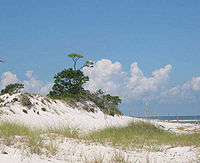
. Along its entire route, it traversed into an area that the Longleaf Pine
s lie next to the sand dunes of the Gulf Of Mexico
. The western terminus is at a parking lot
at Fort Pickens
. The eastern terminus is with an intersection of US 98–SR 30 in Navarre
.
 Beginning at the US 98–SR 30 in Navarre
, it first heads north–south, traveling on the Navarre Bridge, which crosses Santa Rosa Sound
from the mainland to Santa Rosa Island
. The Navarre Bridge was a toll bridge with one cash and one Sunpass
lane for southbound traffic until 2005 but it is now toll-free. In Pensacola Beach
, the road splits, with the north–south causeway to US 98, and the other road leading to Fort Pickens
, which is considered the main road. In Gulf Islands National Seashore
, it ends as a cul-de-sac
at a parking lot
.
Note: U.S. roads are generally numbered under the assumed parameters that odd numbered roads run south-to-north, and even numbered roads run west-to-east direction in order to follow the order of their mileposts. However, this section of SR 399 runs almost exclusively west-to-east.
Escambia County, Florida
Escambia County is the westernmost county in the U.S. state of Florida. The 2010 population was 297,619. The U.S. Census Bureau 2005 estimate for the county is 296,772. Its county seat is Pensacola.- History :...
and Santa Rosa
Santa Rosa County, Florida
Santa Rosa County is a county located in the U.S. state of Florida. According to the 2000 U.S. Census, the population was 117,743, while a July 1, 2005, estimate placed the population at 143,105, an 18% increase making it the 84th fastest growing county in the United States between 2000 and 2005. ...
, although in Santa Rosa County it is known as a county road. It is 28.33 miles (45.59 kilometers) long, mostly on Santa Rosa Island
Santa Rosa Island, Florida
Santa Rosa Island[p] is a 40-mile barrier island located in the U.S. state of Florida, thirty miles east of the Alabama state border...
. It is an access road to Gulf Islands National Seashore
Gulf Islands National Seashore
Gulf Islands National Seashore offers recreation opportunities and preserves natural and historic resources along the Gulf of Mexico barrier islands of Florida and Mississippi. The protected regions include mainland areas and parts of 7 islands...
. Along its entire route, it traversed into an area that the Longleaf Pine
Longleaf Pine
Pinus palustris, commonly known as the Longleaf Pine, is a pine native to the southeastern United States, found along the coastal plain from eastern Texas to southeast Virginia extending into northern and central Florida....
s lie next to the sand dunes of the Gulf Of Mexico
Gulf of Mexico
The Gulf of Mexico is a partially landlocked ocean basin largely surrounded by the North American continent and the island of Cuba. It is bounded on the northeast, north and northwest by the Gulf Coast of the United States, on the southwest and south by Mexico, and on the southeast by Cuba. In...
. The western terminus is at a parking lot
Parking lot
A parking lot , also known as car lot, is a cleared area that is intended for parking vehicles. Usually, the term refers to a dedicated area that has been provided with a durable or semi-durable surface....
at Fort Pickens
Fort Pickens
Fort Pickens is a pentagonal historic United States military fort on Santa Rosa Island in the Pensacola, Florida, area. It is named after American Revolutionary War hero Andrew Pickens. The fort was completed in 1834 and remained in use until 1947...
. The eastern terminus is with an intersection of US 98–SR 30 in Navarre
Navarre, Florida
Navarre is an unincorporated community in Santa Rosa County in the Northwest Florida Panhandle. Navarre is about 25 miles east of Pensacola and about 15 miles west of Fort Walton Beach. The community is roughly centered on the junction of U.S. Route 98 and State Road 87...
.
Route description
Navarre, Florida
Navarre is an unincorporated community in Santa Rosa County in the Northwest Florida Panhandle. Navarre is about 25 miles east of Pensacola and about 15 miles west of Fort Walton Beach. The community is roughly centered on the junction of U.S. Route 98 and State Road 87...
, it first heads north–south, traveling on the Navarre Bridge, which crosses Santa Rosa Sound
Santa Rosa Sound
Santa Rosa Sound is a sound connecting Pensacola Bay and Choctawhatchee Bay in Florida. The northern shore consists of the Fairpoint Peninsula and portions of the mainland in Santa Rosa County and Okaloosa County...
from the mainland to Santa Rosa Island
Santa Rosa Island, Florida
Santa Rosa Island[p] is a 40-mile barrier island located in the U.S. state of Florida, thirty miles east of the Alabama state border...
. The Navarre Bridge was a toll bridge with one cash and one Sunpass
SunPass
SunPass is an electronic toll collection system in use by the State of Florida and was originally created by the Florida Department of Transportation's Florida's Turnpike...
lane for southbound traffic until 2005 but it is now toll-free. In Pensacola Beach
Pensacola Beach, Florida
Pensacola Beach is an unincorporated community located on Santa Rosa Island, a barrier island, in Escambia County, Florida, United States. It is situated south of Pensacola, and Gulf Breeze connected via bridges spanning to the Fairpoint Peninsula and then to the island, on the Gulf of Mexico...
, the road splits, with the north–south causeway to US 98, and the other road leading to Fort Pickens
Fort Pickens
Fort Pickens is a pentagonal historic United States military fort on Santa Rosa Island in the Pensacola, Florida, area. It is named after American Revolutionary War hero Andrew Pickens. The fort was completed in 1834 and remained in use until 1947...
, which is considered the main road. In Gulf Islands National Seashore
Gulf Islands National Seashore
Gulf Islands National Seashore offers recreation opportunities and preserves natural and historic resources along the Gulf of Mexico barrier islands of Florida and Mississippi. The protected regions include mainland areas and parts of 7 islands...
, it ends as a cul-de-sac
Cul-de-sac
A cul-de-sac is a word of French origin referring to a dead end, close, no through road or court meaning dead-end street with only one inlet/outlet...
at a parking lot
Parking lot
A parking lot , also known as car lot, is a cleared area that is intended for parking vehicles. Usually, the term refers to a dedicated area that has been provided with a durable or semi-durable surface....
.
Note: U.S. roads are generally numbered under the assumed parameters that odd numbered roads run south-to-north, and even numbered roads run west-to-east direction in order to follow the order of their mileposts. However, this section of SR 399 runs almost exclusively west-to-east.