

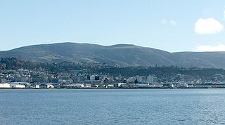
Flagstaff, Otago
Encyclopedia
Dunedin
Dunedin is the second-largest city in the South Island of New Zealand, and the principal city of the Otago Region. It is considered to be one of the four main urban centres of New Zealand for historic, cultural, and geographic reasons. Dunedin was the largest city by territorial land area until...
, in New Zealand
New Zealand
New Zealand is an island country in the south-western Pacific Ocean comprising two main landmasses and numerous smaller islands. The country is situated some east of Australia across the Tasman Sea, and roughly south of the Pacific island nations of New Caledonia, Fiji, and Tonga...
's South Island
South Island
The South Island is the larger of the two major islands of New Zealand, the other being the more populous North Island. It is bordered to the north by Cook Strait, to the west by the Tasman Sea, to the south and east by the Pacific Ocean...
. Together with Mount Cargill
Mount Cargill
Mount Cargill is a 680 metre high volcanic outcrop which dominates the skyline of northern Dunedin, New Zealand. It is situated some 15 kilometres north of the city centre....
, which lies to its northeast, it dominates the skyline of the city. Flagstaff lies seven kilometres to the north of Dunedin's city centre.
The hill was known by the Māori as Whakari, and an anglicised form of this name is still used for the Dunedin suburb of Wakari, which lies to the south of Flagstaff. The first European name for the hill was Mount Kettle, after an early surveyor, Charles Kettle
Charles Kettle
Charles Henry Kettle surveyed the city of Dunedin in New Zealand, imposing a bold design on a challenging landscape. He was aiming to create a Romantic effect and incidentally produced the world's steepest street, Baldwin Street....
. The city's first road route to the Taieri Plains
Taieri Plains
The Taieri Plains are an area of fertile agricultural land to the southwest of Dunedin, in Otago, New Zealand. The plains cover an area of some 300 square kilometres, with a maximum extent of 30 kilometres....
, which lie to the west, skirted the slopes of Flagstaff, and is still used as an alternative route out of the city.
Flagstaff rises to a height of 666 metres, and is part of the rim of the Dunedin Volcano, a long-extinct volcano of which the crater forms the Otago Harbour
Otago Harbour
Otago Harbour is the natural harbour of Dunedin, New Zealand, consisting of a long, much-indented stretch of generally navigable water separating the Otago Peninsula from the mainland. They join at its southwest end, from the harbour mouth...
. The Pineapple Track, part of Dunedin's Skyline Walkway, crosses the peak of Flagstaff. This track, though not an arduous walk, needs to be treated with care, as the weather around Flagstaff can be extremely unpredictable.
