
Ferragudo
Encyclopedia
Ferragudo is a Portuguese
civil parish
at the western border of the municipality of Lagoa Municipality, covering an area of 5.41 km² and encompassing a small population of 1867 inhabitants (2001 census). Ferragudo serves mainly as a bedroom community for its much larger neighbour, the city of Portimão
; its residents routinely travel across the Arade River to work in the neighboring municipality.
Ferragudo was selected by Phoenicians, Carthiginians and Roman, who were attracted to the mouth of the Arade River for its shelter and access to the Atlantic Ocean. It was in the 14th century that fishers began to settle the region, primarily to avoid the winter storms that afflicted the Atlantic coast. In 1520, Queen Leonor, noting the potential of area, secured the protection of the area, and thereby allowed continued occupation of the territory. The privileges conceded to the region mimicked those extended to Silves and its inhabitants. Consequently, the Bishop of the Algarve, began to reside in the zone. Similarly, the Bishop of Silves, D.
Fernando Coutinho had erected a wall to protect the population, at the same time ordering the construction of the local castle, remaining in the area until his death.
In the 18th century, the local area evolved with its base in the fishery and interior agriculture, secure in the support of the monarchy, resulting in a population growth. This change led to the de-annexation of the territory of Ferragudo from Estômbar in 1749. For along time the territory of Ferragudo was shared between its neighbouring parishes of Lagoa and of Estômbar
, after it was deannexed from the municipality of Silves on 26 January 1773.
The continued growth of the canning/preservation industry, allowed Ferragudo to prosper. Until the late 20th century, Ferragudo was a fishing community that depended on seasonal employment along the Arade River or in the Atlantic Ocean and the estuary
of the Arade River and the river itself. With the collapse of fishing along the southern coast, the civil parish began to move to a tertiary economic model, concentrating on attracting tourism into the region.
On 3 May 1999 the village was elevated to the civil status of town, absorbing the villages and hamlets of Aldeia de São Francisco, Vale de Azinhaga, Corgos, Gramacho, Presa de Moura and Vale de Lapa.
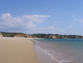 The civil parish is bordered on the west and south by Arade River and the Atlantic Ocean, and its landscapes are coloured by the fishing economy and tourist beaches, such as Angrinha
, Caneiros, Torrados, Infanta, Afurada, João Lopes, Molhe, Pintadinho and Praia Grande
. It is situated between the parish of Parchal (in the north), Estômbar (in the east) and the municipality of Portimão
(in the west, across the Arade River). The population is concentrated along the E.N.539 motorway and Atlantic coast, separated into two principal localities: Ferragudo and Vale de Azinhaga.
Among the natural scenic sites is the Ponta do Altar as well as various cliffs, underground caverns, vent chimneys and steep cliffed islets.
Portugal
Portugal , officially the Portuguese Republic is a country situated in southwestern Europe on the Iberian Peninsula. Portugal is the westernmost country of Europe, and is bordered by the Atlantic Ocean to the West and South and by Spain to the North and East. The Atlantic archipelagos of the...
civil parish
Freguesia
Freguesia is the Portuguese term for a secondary local administrative unit in Portugal and some of its former colonies, and a former secondary local administrative unit in Macau, roughly equivalent to an administrative parish. A freguesia is a subdivision of a concelho, the Portuguese synonym term...
at the western border of the municipality of Lagoa Municipality, covering an area of 5.41 km² and encompassing a small population of 1867 inhabitants (2001 census). Ferragudo serves mainly as a bedroom community for its much larger neighbour, the city of Portimão
Portimão
Portimão is a Portuguese town located in the District of Faro in the Region of Algarve, the southern coast of Portugal. It was formerly known as Vila Nova de Portimão . In 1924, it was incorporated as a cidade and became known merely as Portimão. The town has 41,000 inhabitants and the Portimão...
; its residents routinely travel across the Arade River to work in the neighboring municipality.
History
There have been various explanations for the communities name: from the inheritance of Ferragudo in Castro Verde, the fort of Ferragudo in Vila Viçosa, the Spanishman Johane Anes Ferro Agudo de Espanha or the locality of Ferragudo, there have been several interpretations. Of the most plausible interpretations, the most sensible has been the traditional associated to the 14th century, which suggested the existance of a iron machine that existed on the beach of Angrinha, and which was used to raise fish for market. This iron machinery or "engenho de ferro", which was relatively "pointy" or "agudo" evolved into "ferro agudo" or Ferragudo.Ferragudo was selected by Phoenicians, Carthiginians and Roman, who were attracted to the mouth of the Arade River for its shelter and access to the Atlantic Ocean. It was in the 14th century that fishers began to settle the region, primarily to avoid the winter storms that afflicted the Atlantic coast. In 1520, Queen Leonor, noting the potential of area, secured the protection of the area, and thereby allowed continued occupation of the territory. The privileges conceded to the region mimicked those extended to Silves and its inhabitants. Consequently, the Bishop of the Algarve, began to reside in the zone. Similarly, the Bishop of Silves, D.
Dom (title)
Dom is a title of respect prefixed to the given name. It derives from Latin Dominus.It is used in English for certain Benedictine and Carthusian monks, and for members of certain communities of Canons Regular. Examples include Benedictine monks of the English Benedictine Congregation...
Fernando Coutinho had erected a wall to protect the population, at the same time ordering the construction of the local castle, remaining in the area until his death.
In the 18th century, the local area evolved with its base in the fishery and interior agriculture, secure in the support of the monarchy, resulting in a population growth. This change led to the de-annexation of the territory of Ferragudo from Estômbar in 1749. For along time the territory of Ferragudo was shared between its neighbouring parishes of Lagoa and of Estômbar
Estômbar
Estômbar is a Portuguese civil parish/freguesia in the municipality/concelho of Lagoa, just west of the city of Lagoa itself. It is 23.83 km² in area, with 4,658 inhabitants ; the population density is 195.5 inhabitants per km²...
, after it was deannexed from the municipality of Silves on 26 January 1773.
The continued growth of the canning/preservation industry, allowed Ferragudo to prosper. Until the late 20th century, Ferragudo was a fishing community that depended on seasonal employment along the Arade River or in the Atlantic Ocean and the estuary
Estuary
An estuary is a partly enclosed coastal body of water with one or more rivers or streams flowing into it, and with a free connection to the open sea....
of the Arade River and the river itself. With the collapse of fishing along the southern coast, the civil parish began to move to a tertiary economic model, concentrating on attracting tourism into the region.
On 3 May 1999 the village was elevated to the civil status of town, absorbing the villages and hamlets of Aldeia de São Francisco, Vale de Azinhaga, Corgos, Gramacho, Presa de Moura and Vale de Lapa.
Geography
Praia da Angrinha (Ferragudo)
Praia da Angrinha is situated along the wide estuary of the Rio Arade, south of Ferragudo, in the municipality/concelho of Lagoa.Map location:...
, Caneiros, Torrados, Infanta, Afurada, João Lopes, Molhe, Pintadinho and Praia Grande
Praia Grande (Ferragudo)
Praia Grande is on the east bank of the wide estuary of the Rio Arade, south of Ferragudo, in the municipality/concelho of Lagoa , in Portugal.Map location:...
. It is situated between the parish of Parchal (in the north), Estômbar (in the east) and the municipality of Portimão
Portimão Municipality
Portimão is a municipality in the district of Faro, in the Algarve region of southern Portugal. Historically a fishing and ship-building centre, it has nonetheless developed into a strong tourist centre oriented along its beaches and southern coast.-History:...
(in the west, across the Arade River). The population is concentrated along the E.N.539 motorway and Atlantic coast, separated into two principal localities: Ferragudo and Vale de Azinhaga.
Among the natural scenic sites is the Ponta do Altar as well as various cliffs, underground caverns, vent chimneys and steep cliffed islets.
Economy
For a long time the population of Ferragudo was connect with the fishery, suffering the ups and downs associated with this seasonal shifts. Meanwhile agriculture and the raising of cattle/dairy herds was always present within the territory (also influenced by the changes in the business cycles), while the cultivation of almonds, figs and carob predominated. Ferragudo, which in the past was the centre of a cattle fair historically, has traditionally be the location of several fish canning and/or conservancy industries. While this has been steadily abandoned, due to the growth of touris, there are still many fishermen that sail from the ports of the region.Civic
- Fishing village/shacks
- Lifeguard station of Ferragudo
- Lighthouse of Ponta do Altar
Military
- Atalaia da Ponta do Altar
- Fort of São João do AradeFort of São João do AradeThe Fort of São João do Arade is located in the Algarve in the town and civil parish/freguesia of Ferragudo, in the municipality/concelho of Lagoa, in Portugal.Map location: Situated in a dominant position at the mouth of the Rio...
Religious
- Church of Nossa Senhora da Conceição