

Fayette County, Illinois
Encyclopedia
Fayette County is a county located in the U.S. state
of Illinois
. According to the 2010 census, it has a population of 22,140, which is an increase of 1.6% from 21,802 in 2000. Its county seat
is Vandalia
. Ramsey Lake State Recreation Area
is located in the northwest part of this county.
, Clark, and Crawford Counties. It was named in honor of the Marquis de LaFayette
, French hero of the American Revolutionary War.
:
 ]
]
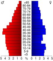
As of the census
of 2000, there were 21,802 people, 8,146 households, and 5,653 families residing in the county. The population density
was 30 people per square mile (12/km²). There were 9,053 housing units at an average density of 13 per square mile (5/km²). The racial makeup of the county was 94.02% White
, 4.88% Black
or African American
, 0.12% Native American
, 0.17% Asian
, 0.02% Pacific Islander
, 0.25% from other races
, and 0.54% from two or more races. 0.80% of the population were Hispanic
or Latino
of any race. 34.7% were of German
, 23.5% American
, 11.6% English
and 9.6% Irish
ancestry according to Census 2000. 98.2% spoke English
and 1.3% Spanish
as their first language.
There were 8,146 households out of which 31.90% had children under the age of 18 living with them, 56.60% were married couples
living together, 8.50% had a female householder with no husband present, and 30.60% were non-families. 27.20% of all households were made up of individuals and 13.60% had someone living alone who was 65 years of age or older. The average household size was 2.46 and the average family size was 2.98.
In the county the population was spread out with 23.80% under the age of 18, 9.00% from 18 to 24, 29.30% from 25 to 44, 21.90% from 45 to 64, and 15.90% who were 65 years of age or older. The median age was 38 years. For every 100 females there were 108.60 males. For every 100 females age 18 and over, there were 111.50 males.
The median income for a household in the county was $31,873, and the median income for a family was $39,044. Males had a median income of $29,478 versus $20,254 for females. The per capita income
for the county was $15,357. About 8.40% of families and 12.20% of the population were below the poverty line, including 15.60% of those under age 18 and 11.90% of those age 65 or over.
U.S. state
A U.S. state is any one of the 50 federated states of the United States of America that share sovereignty with the federal government. Because of this shared sovereignty, an American is a citizen both of the federal entity and of his or her state of domicile. Four states use the official title of...
of Illinois
Illinois
Illinois is the fifth-most populous state of the United States of America, and is often noted for being a microcosm of the entire country. With Chicago in the northeast, small industrial cities and great agricultural productivity in central and northern Illinois, and natural resources like coal,...
. According to the 2010 census, it has a population of 22,140, which is an increase of 1.6% from 21,802 in 2000. Its county seat
County seat
A county seat is an administrative center, or seat of government, for a county or civil parish. The term is primarily used in the United States....
is Vandalia
Vandalia, Illinois
Vandalia is a city in Fayette County, Illinois, United States, northeast of St. Louis, on the Kaskaskia River. From 1819 to 1839 it served as the state capital of Illinois. Vandalia was the western terminus of the National Road. Today it is the county seat of Fayette County and the home of the...
. Ramsey Lake State Recreation Area
Ramsey Lake State Recreation Area
Ramsey Lake State Recreation Area is a 1,980 acre state park located in Fayette County, Illinois, United States. The nearest town is Ramsey, Illinois, and the park is adjacent to U.S. Highway 51...
is located in the northwest part of this county.
Geography
According to the 2010 census, the county has a total area of 725.34 square miles (1,878.6 km²), of which 716.48 square miles (1,855.7 km²) (or 98.78%) is land and 8.86 square miles (22.9 km²) (or 1.22%) is water.Adjacent counties
- Shelby County - northeast
- Effingham County - east
- Clay CountyClay County, IllinoisClay County is a county located in the U.S. state of Illinois. In 1950, the U.S. Census Bureau placed the mean center of U.S. population in Clay County. According to the 2010 census, it has a population of 13,815, which is a decrease of 5.1% from 14,560 in 2000...
- southeast - Marion County - south
- Clinton CountyClinton County, Illinois-Demographics: As of the census of 2000, there were 35,535 people, 12,754 households, and 9,221 families residing in the county. The population density was 75 people per square mile . There were 13,805 housing units at an average density of 29 per square mile...
- southwest - Bond CountyBond County, IllinoisBond County is a county located in the U.S. state of Illinois. It is part of the St. Louis Metro Area. According to the 2010 census, it has a population of 17,768, which is an increase of 0.8% from 17,633 in 2000. Its county seat is Greenville, Illinois....
- west - Montgomery County - northwest
Major highways
-
 Interstate 57Interstate 57Interstate 57 is an Interstate Highway in Missouri and Illinois that parallels the old Illinois Central rail line for much of its route. It goes from Miner, Missouri, at Interstate 55 to Chicago, Illinois, at Interstate 94. I-57 essentially serves as a shortcut route for travelers headed between...
 -
 Interstate 70Interstate 70Interstate 70 is an Interstate Highway in the United States that runs from Interstate 15 near Cove Fort, Utah, to a Park and Ride near Baltimore, Maryland. It was the first Interstate Highway project in the United States. I-70 approximately traces the path of U.S. Route 40 east of the Rocky...
 -
 US Route 40
 -
 US Route 51
 -
 Illinois Route 33Illinois Route 33Illinois Route 33 is a multidirectional highway in southeastern Illinois, with its western terminus at Illinois Route 128 on the Fayette–Effingham county line near Beecher City and its southern terminus at U.S. Highway 50 east of Lawrenceville. It also overlaps Illinois Route 32 from Shumway to...
 -
 Illinois Route 128Illinois Route 128Illinois Route 128 is a north–south state road in east-central Illinois. It runs from Interstate 70 in Altamont to Illinois Route 121 in Dalton City. This is a distance of .- Route description :...
 -
 Illinois Route 140Illinois Route 140Illinois Route 140 is an east–west highway with its western terminus at Alton and its eastern terminus at Illinois Route 185 and U.S. Route 40 in Vandalia. It also overlaps Illinois Route 111 in Alton and Illinois Route 127 in Greenville...
 -
 Illinois Route 185Illinois Route 185Illinois Route 185 is an east–west state road in the south-central portion of the U.S. state of Illinois. Its western terminus is in Taylor Springs at Illinois Route 127, and the eastern terminus is at Farina at Illinois Route 37. This is a distance of ....
History
Fayette County was formed in 1821 out of BondBond County, Illinois
Bond County is a county located in the U.S. state of Illinois. It is part of the St. Louis Metro Area. According to the 2010 census, it has a population of 17,768, which is an increase of 0.8% from 17,633 in 2000. Its county seat is Greenville, Illinois....
, Clark, and Crawford Counties. It was named in honor of the Marquis de LaFayette
Gilbert du Motier, marquis de La Fayette
Marie-Joseph Paul Yves Roch Gilbert du Motier, Marquis de La Fayette , often known as simply Lafayette, was a French aristocrat and military officer born in Chavaniac, in the province of Auvergne in south central France...
, French hero of the American Revolutionary War.
Villages
- BinghamBingham, IllinoisBingham is a village in Fayette County, Illinois, United States. The population was 117 at the 2000 census.-Geography:Bingham is located at ....
- BrownstownBrownstown, IllinoisBrownstown is a village in Fayette County, Illinois, United States. The population was 705 at the 2000 census.-Geography:Brownstown is located at ....
- FarinaFarina, IllinoisFarina is a village in Fayette County, Illinois, United States. As of the 1990 census, the village population was 575, in 254 housing units. The population was 558 at the 2000 census...
- RamseyRamsey, IllinoisRamsey is a village in Fayette County, Illinois, United States. The population was 1,056 at the 2000 census.-Geography:Ramsey is located at...
- St. PeterSt. Peter, IllinoisSt. Peter is a village in Fayette County, Illinois, United States. The population was 386 at the 2000 census.-Geography:St. Peter is located at ....
Unincorporated
- Augsburg
- Bayle
- Bluff City
- Confidence
- Four Mile
- Frogtown
- HagarstownHagarstown, IllinoisHagarstown is an unincorporated community in Fayette County, Illinois, United States. Hagarstown is southwest of Vandalia. Hagarstown has a post office with ZIP code 62247....
- LoogooteeLoogootee, IllinoisLoogootee is an unincorporated community in Fayette County, Illinois, United States. Loogootee is located along a railroad line north of St. Peter. Loogootee had a post office, which closed on June 17, 2011....
- PittsburgPittsburg, IllinoisPittsburg is a village in Williamson County, Illinois, United States. The population was 575 at the 2000 census.-Geography:Pittsburg is located at ....
- Shafter
- ShobonierShobonier, IllinoisShobonier is an unincorporated community, located on U.S. Route 51, about 10 miles south of Vandalia, Illinois in Fayette County, Illinois. The population was 837 at the 2000 census.-Demographics:*White Population - 825;*Black Population - 2;...
- St. Paul
- Stringtown
- VeraVera, IllinoisVera is an unincorporated community in Sharon Township, Fayette County, Illinois, USA.-Geography:Vera is located at at an elevation of ....
- Woodyard
Townships
Fayette County is divided into twenty townshipsCivil township
A civil township is a widely used unit of local government in the United States, subordinate to, and geographic divisions of, a county. Specific responsibilities and the degree of autonomy vary based on each state. Civil townships are distinct from survey townships, but in states that have both,...
:
|
LaClede Township, Fayette County, Illinois LaClede Township is one of twenty townships in Fayette County, Illinois, USA. As of the 2000 census, its population was 917.-Geography:According to the United States Census Bureau, LaClede Township covers an area of ; of this, or 0.12 percent is water.... Lone Grove Township, Fayette County, Illinois Lone Grove Township is one of twenty townships in Fayette County, Illinois, USA. As of the 2000 census, its population was 707. This township was formed from LaClede and Wilberton townships in September 1876.-Geography:... Loudon Township, Fayette County, Illinois Loudon Township is one of twenty townships in Fayette County, Illinois, USA. As of the 2000 census, its population was 676.-Geography:According to the United States Census Bureau, Loudon Township covers an area of ; of this, or 0.06 percent is water.... North Hurricane Township, Fayette County, Illinois North Hurricane Township is one of twenty townships in Fayette County, Illinois, USA. As of the 2000 census, its population was 247. This township, along with South Hurricane Township, formed when Hurricane Township split sometime after 1921.-Geography:... Otego Township, Fayette County, Illinois Otego Township is one of twenty townships in Fayette County, Illinois, USA. As of the 2000 census, its population was 1,438. Its name changed from Cumberland township on September 24, 1860... |
Pope Township, Fayette County, Illinois Pope Township is one of twenty townships in Fayette County, Illinois, USA. As of the 2000 census, its population was 226. It was formed from part of Kaskaskia Township in March 1878.-Geography:... Ramsey Township, Fayette County, Illinois Ramsey Township is one of 20 townships in Fayette County, Illinois, USA. As of the 2000 census, its population was 1,885.-Geography:According to the United States Census Bureau, Ramsey Township covers an area of ; of this, or 0.23 percent is water.... Sefton Township, Fayette County, Illinois Sefton Township is one of twenty townships in Fayette County, Illinois, USA. As of the 2000 census, its population was 605.-Geography:According to the United States Census Bureau, Sefton Township covers an area of ; of this, or 0.05 percent is water.... Seminary Township, Fayette County, Illinois Seminary Township is one of twenty townships in Fayette County, Illinois, USA. As of the 2000 census, its population was 538.-Geography:According to the United States Census Bureau, Seminary Township covers an area of ; of this, or 4.17 percent is water.... Shafter Township, Fayette County, Illinois Shafter Township is one of twenty townships in Fayette County, Illinois, USA. As of the 2000 census, its population was 468. Shafter Township was formed out of Sharon Township in December, 1920.-Geography:... |
Sharon Township, Fayette County, Illinois Sharon Township is one of twenty townships in Fayette County, Illinois, USA. As of the 2000 census, its population was 940.-Geography:According to the United States Census Bureau, Sharon Township covers an area of ; of this, or 1.6 percent is water.... South Hurricane Township, Fayette County, Illinois South Hurricane Township is one of twenty townships in Fayette County, Illinois, USA. As of the 2000 census, its population was 335. This township, along with North Hurricane Township, was formed when Hurricane Township split sometime after 1921.-Geography:... Vandalia Township, Fayette County, Illinois Vandalia Township is one of twenty townships in Fayette County, Illinois, USA. At the 2000 census, its population was 8,104.-Geography:According to the United States Census Bureau, Vandalia Township covers an area of ; of this, or 0.82 percent is water.... Wheatland Township, Fayette County, Illinois Wheatland Township is one of twenty townships in Fayette County, Illinois, USA. As of the 2000 census, its population was 490.-Geography:According to the United States Census Bureau, Wheatland Township covers an area of ; of this, or 0.11 percent is water.... Wilberton Township, Fayette County, Illinois Wilberton Township is one of twenty townships in Fayette County, Illinois, USA. As of the 2000 census, its population was 465. Its name changed from Richland Township on September 24, 1860.-Geography:... |
Demographics
As of the census
Census
A census is the procedure of systematically acquiring and recording information about the members of a given population. It is a regularly occurring and official count of a particular population. The term is used mostly in connection with national population and housing censuses; other common...
of 2000, there were 21,802 people, 8,146 households, and 5,653 families residing in the county. The population density
Population density
Population density is a measurement of population per unit area or unit volume. It is frequently applied to living organisms, and particularly to humans...
was 30 people per square mile (12/km²). There were 9,053 housing units at an average density of 13 per square mile (5/km²). The racial makeup of the county was 94.02% White
Race (United States Census)
Race and ethnicity in the United States Census, as defined by the Federal Office of Management and Budget and the United States Census Bureau, are self-identification data items in which residents choose the race or races with which they most closely identify, and indicate whether or not they are...
, 4.88% Black
Race (United States Census)
Race and ethnicity in the United States Census, as defined by the Federal Office of Management and Budget and the United States Census Bureau, are self-identification data items in which residents choose the race or races with which they most closely identify, and indicate whether or not they are...
or African American
Race (United States Census)
Race and ethnicity in the United States Census, as defined by the Federal Office of Management and Budget and the United States Census Bureau, are self-identification data items in which residents choose the race or races with which they most closely identify, and indicate whether or not they are...
, 0.12% Native American
Race (United States Census)
Race and ethnicity in the United States Census, as defined by the Federal Office of Management and Budget and the United States Census Bureau, are self-identification data items in which residents choose the race or races with which they most closely identify, and indicate whether or not they are...
, 0.17% Asian
Race (United States Census)
Race and ethnicity in the United States Census, as defined by the Federal Office of Management and Budget and the United States Census Bureau, are self-identification data items in which residents choose the race or races with which they most closely identify, and indicate whether or not they are...
, 0.02% Pacific Islander
Race (United States Census)
Race and ethnicity in the United States Census, as defined by the Federal Office of Management and Budget and the United States Census Bureau, are self-identification data items in which residents choose the race or races with which they most closely identify, and indicate whether or not they are...
, 0.25% from other races
Race (United States Census)
Race and ethnicity in the United States Census, as defined by the Federal Office of Management and Budget and the United States Census Bureau, are self-identification data items in which residents choose the race or races with which they most closely identify, and indicate whether or not they are...
, and 0.54% from two or more races. 0.80% of the population were Hispanic
Race (United States Census)
Race and ethnicity in the United States Census, as defined by the Federal Office of Management and Budget and the United States Census Bureau, are self-identification data items in which residents choose the race or races with which they most closely identify, and indicate whether or not they are...
or Latino
Race (United States Census)
Race and ethnicity in the United States Census, as defined by the Federal Office of Management and Budget and the United States Census Bureau, are self-identification data items in which residents choose the race or races with which they most closely identify, and indicate whether or not they are...
of any race. 34.7% were of German
Germans
The Germans are a Germanic ethnic group native to Central Europe. The English term Germans has referred to the German-speaking population of the Holy Roman Empire since the Late Middle Ages....
, 23.5% American
United States
The United States of America is a federal constitutional republic comprising fifty states and a federal district...
, 11.6% English
English people
The English are a nation and ethnic group native to England, who speak English. The English identity is of early mediaeval origin, when they were known in Old English as the Anglecynn. England is now a country of the United Kingdom, and the majority of English people in England are British Citizens...
and 9.6% Irish
Irish people
The Irish people are an ethnic group who originate in Ireland, an island in northwestern Europe. Ireland has been populated for around 9,000 years , with the Irish people's earliest ancestors recorded having legends of being descended from groups such as the Nemedians, Fomorians, Fir Bolg, Tuatha...
ancestry according to Census 2000. 98.2% spoke English
English language
English is a West Germanic language that arose in the Anglo-Saxon kingdoms of England and spread into what was to become south-east Scotland under the influence of the Anglian medieval kingdom of Northumbria...
and 1.3% Spanish
Spanish language
Spanish , also known as Castilian , is a Romance language in the Ibero-Romance group that evolved from several languages and dialects in central-northern Iberia around the 9th century and gradually spread with the expansion of the Kingdom of Castile into central and southern Iberia during the...
as their first language.
There were 8,146 households out of which 31.90% had children under the age of 18 living with them, 56.60% were married couples
Marriage
Marriage is a social union or legal contract between people that creates kinship. It is an institution in which interpersonal relationships, usually intimate and sexual, are acknowledged in a variety of ways, depending on the culture or subculture in which it is found...
living together, 8.50% had a female householder with no husband present, and 30.60% were non-families. 27.20% of all households were made up of individuals and 13.60% had someone living alone who was 65 years of age or older. The average household size was 2.46 and the average family size was 2.98.
In the county the population was spread out with 23.80% under the age of 18, 9.00% from 18 to 24, 29.30% from 25 to 44, 21.90% from 45 to 64, and 15.90% who were 65 years of age or older. The median age was 38 years. For every 100 females there were 108.60 males. For every 100 females age 18 and over, there were 111.50 males.
The median income for a household in the county was $31,873, and the median income for a family was $39,044. Males had a median income of $29,478 versus $20,254 for females. The per capita income
Per capita income
Per capita income or income per person is a measure of mean income within an economic aggregate, such as a country or city. It is calculated by taking a measure of all sources of income in the aggregate and dividing it by the total population...
for the county was $15,357. About 8.40% of families and 12.20% of the population were below the poverty line, including 15.60% of those under age 18 and 11.90% of those age 65 or over.
Climate and weather
In recent years, average temperatures in the county seat of Vandalia have ranged from a low of 18 °F (-7.8 °C) in January to a high of 88 °F (31.1 °C) in July, although a record low of -21 °F was recorded in January 1985 and a record high of 104 °F (40 °C) was recorded in July 1980. Average monthly precipitation ranged from 2.41 inches (6.1 cm) in February to 4.11 inches (10.4 cm) in May.See also
- National Register of Historic Places listings in Fayette County, Illinois