

Extreme points of Russia
Encyclopedia
This is a list of the extreme points and extreme elevations in Russia
.
The northernmost and easternmost points of Russia coincide with those of Eurasia
(both for the mainland and including the islands).
The extreme points of the Soviet Union
were identical, except that the southernmost point of the Soviet Union was Kushka
in Turkmenistan
, and the extreme elevation was the Communism Peak in Tajikistan
, at 7,495 m.
From 1799 until 1867 the easternmost point of the Russian Empire
was located in North America
, on the border between Russian Alaska
and British North America
, which superimposed on the then International Date Line
. The westernmost point of the Empire was located at Pyzdry
in Congress Poland
from 1815 until its occupation by German and Austro-Hungarian troops
in 1915. Kushka
in present-day Turkmenistan
has been the southernmost point of the Empire since 1885. Again, until the Alaska Purchase
, the peak of Mount McKinley
was the extreme point of elevation in the Empire, at 6,194 m above sea level.
The remaining extreme points were the same as the extreme points of the Soviet Union.
Contiguous mainland only
Towns and cities
Permanent settlements
1according to the path of the International Date Line
.
Russia
Russia or , officially known as both Russia and the Russian Federation , is a country in northern Eurasia. It is a federal semi-presidential republic, comprising 83 federal subjects...
.
The northernmost and easternmost points of Russia coincide with those of Eurasia
Extreme points of Eurasia
This is a list of the extreme points of Eurasia, the points that are farther north, south, east or west than any other location on the continent...
(both for the mainland and including the islands).
The extreme points of the Soviet Union
Soviet Union
The Soviet Union , officially the Union of Soviet Socialist Republics , was a constitutionally socialist state that existed in Eurasia between 1922 and 1991....
were identical, except that the southernmost point of the Soviet Union was Kushka
Serhetabat
Serhetabat is a small town in the Mary Province in Turkmenistan, located in the valley of the Kushka River. Population: 5,200 ....
in Turkmenistan
Turkmenistan
Turkmenistan , formerly also known as Turkmenia is one of the Turkic states in Central Asia. Until 1991, it was a constituent republic of the Soviet Union, the Turkmen Soviet Socialist Republic . Turkmenistan is one of the six independent Turkic states...
, and the extreme elevation was the Communism Peak in Tajikistan
Tajikistan
Tajikistan , officially the Republic of Tajikistan , is a mountainous landlocked country in Central Asia. Afghanistan borders it to the south, Uzbekistan to the west, Kyrgyzstan to the north, and China to the east....
, at 7,495 m.
From 1799 until 1867 the easternmost point of the Russian Empire
Russian Empire
The Russian Empire was a state that existed from 1721 until the Russian Revolution of 1917. It was the successor to the Tsardom of Russia and the predecessor of the Soviet Union...
was located in North America
North America
North America is a continent wholly within the Northern Hemisphere and almost wholly within the Western Hemisphere. It is also considered a northern subcontinent of the Americas...
, on the border between Russian Alaska
Russian Alaska
Russian America was the name of Russian colonial possessions in the Americas from 1733 to 1867 that today is the U.S. state of Alaska and settlements farther south in California and Hawaii...
and British North America
British North America
British North America is a historical term. It consisted of the colonies and territories of the British Empire in continental North America after the end of the American Revolutionary War and the recognition of American independence in 1783.At the start of the Revolutionary War in 1775 the British...
, which superimposed on the then International Date Line
International Date Line
The International Date Line is a generally north-south imaginary line on the surface of the Earth, passing through the middle of the Pacific Ocean, that designates the place where each calendar day begins...
. The westernmost point of the Empire was located at Pyzdry
Pyzdry
Pyzdry is a town in Września County, Greater Poland Voivodeship, Poland, with 3,163 inhabitants .- History :In 1390 the treaty of Pyzdry was signed there. In 1815 the town was the western most point of the Russian Empire. There was a narrow-gauge railway in Pyzdry....
in Congress Poland
Congress Poland
The Kingdom of Poland , informally known as Congress Poland , created in 1815 by the Congress of Vienna, was a personal union of the Russian parcel of Poland with the Russian Empire...
from 1815 until its occupation by German and Austro-Hungarian troops
Eastern Front (World War I)
The Eastern Front was a theatre of war during World War I in Central and, primarily, Eastern Europe. The term is in contrast to the Western Front. Despite the geographical separation, the events in the two theatres strongly influenced each other...
in 1915. Kushka
Serhetabat
Serhetabat is a small town in the Mary Province in Turkmenistan, located in the valley of the Kushka River. Population: 5,200 ....
in present-day Turkmenistan
Turkmenistan
Turkmenistan , formerly also known as Turkmenia is one of the Turkic states in Central Asia. Until 1991, it was a constituent republic of the Soviet Union, the Turkmen Soviet Socialist Republic . Turkmenistan is one of the six independent Turkic states...
has been the southernmost point of the Empire since 1885. Again, until the Alaska Purchase
Alaska purchase
The Alaska Purchase was the acquisition of the Alaska territory by the United States from Russia in 1867 by a treaty ratified by the Senate. The purchase, made at the initiative of United States Secretary of State William H. Seward, gained of new United States territory...
, the peak of Mount McKinley
Mount McKinley
Mount McKinley or Denali in Alaska, United States is the highest mountain peak in North America and the United States, with a summit elevation of above sea level. It is the centerpiece of Denali National Park and Preserve.- Geology and features :Mount McKinley is a granitic pluton...
was the extreme point of elevation in the Empire, at 6,194 m above sea level.
The remaining extreme points were the same as the extreme points of the Soviet Union.
Extreme coordinates
Including islands and exclaves- Northernmost point — Cape Fligely, Franz Josef LandFranz Josef LandFranz Josef Land, Franz Joseph Land, or Francis Joseph's Land is an archipelago located in the far north of Russia. It is found in the Arctic Ocean north of Novaya Zemlya and east of Svalbard, and is administered by Arkhangelsk Oblast. Franz Josef Land consists of 191 ice-covered islands with a...
, Nenets Autonomous OkrugNenets Autonomous OkrugNenets Autonomous Okrug is a federal subject of Russia .It has an area of 176,700 km2 and population of 42,628 as of the preliminary results of the 2010 Census , 21,296 of whom live in Naryan-Mar, the administrative center.-Geography and ecology:The arctic ecology of this...
(81°50′35"N 59°14′22"E) - Southernmost point — Mount Bazardyuzyu, Republic of DagestanDagestanThe Republic of Dagestan is a federal subject of Russia, located in the North Caucasus region. Its capital and the largest city is Makhachkala, located at the center of Dagestan on the Caspian Sea...
(41°13′14"N 47°51′28"E) - Westernmost point — Narmeln, Vistula SpitVistula SpitThe Vistula Spit is a spit, or peninsular stretch of land, which separates Vistula Lagoon from Gdańsk Bay in the Baltic Sea. The border between Poland and Kaliningrad Oblast, an exclave of Russia, bisects it, politically dividing the spit in half between the two countries. The westernmost point...
, Kaliningrad OblastKaliningrad OblastKaliningrad Oblast is a federal subject of Russia situated on the Baltic coast. It has a population of The oblast forms the westernmost part of the Russian Federation, but it has no land connection to the rest of Russia. Since its creation it has been an exclave of the Russian SFSR and then the...
(19°38'E) - Easternmost point1 — Big Diomede IslandDiomede IslandsThe Diomede Islands , also known in Russia as Gvozdev Islands , consist of two rocky, tuya-like islands:* The U.S. island of Little Diomede or, in its native language, Ignaluk , and* The Russian island of Big Diomede , also known as Imaqliq,...
, Chukotka Autonomous OkrugChukotka Autonomous OkrugChukotka Autonomous Okrug , or Chukotka , is a federal subject of Russia located in the Russian Far East.Chukotka has a population of 53,824 according to the 2002 Census, and a surface area of . The principal town and the administrative center is Anadyr...
(65°47′N 169°01′W)
Contiguous mainland only
- Northernmost point — Cape ChelyuskinCape ChelyuskinCape Chelyuskin is the northernmost point of the Eurasian continent , and the northernmost point of mainland Russia. It is situated at the tip of the Taymyr Peninsula, south of Severnaya Zemlya archipelago, in Krasnoyarsk Krai, Russia...
, Krasnoyarsk KraiKrasnoyarsk KraiKrasnoyarsk Krai is a federal subject of Russia . It is the second largest federal subject after the Sakha Republic, and Russia's largest krai, occupying an area of , which is 13% of the country's total territory. The administrative center of the krai is the city of Krasnoyarsk...
(77°43'N) - Southernmost point — Mount Bazardyuzyu, Republic of DagestanDagestanThe Republic of Dagestan is a federal subject of Russia, located in the North Caucasus region. Its capital and the largest city is Makhachkala, located at the center of Dagestan on the Caspian Sea...
(41°12'N) - Westernmost point — near Lavry, Pskov OblastPskov OblastPskov Oblast is a federal subject of Russia . Pskov Oblast borders the countries of Estonia and Latvia, as well as Belarus. It is the westernmost federal subject of contiguous Russia . Its major cities are the administrative center Pskov and Velikiye Luki . Area: 55,300 km²...
(27°19'E) - Easternmost point1 — Cape DezhnevCape DezhnevCape Dezhnyov or Cape Dezhnev is a cape that forms the eastmost mainland point of Eurasia. It is located on the Chukchi Peninsula in the very thinly populated Chukotka Autonomous Okrug of Russia. This cape is located between the Bering Sea and the Chukchi Sea, across from Cape Prince of Wales in...
(East Cape), Chukotka Autonomous OkrugChukotka Autonomous OkrugChukotka Autonomous Okrug , or Chukotka , is a federal subject of Russia located in the Russian Far East.Chukotka has a population of 53,824 according to the 2002 Census, and a surface area of . The principal town and the administrative center is Anadyr...
(169°40'W)
Towns and cities
- Northernmost — PevekPevekPevek is a town and Arctic port in Chaunsky District, part of the Chukotka Autonomous Okrug, Russia. After Anadyr and Bilibino it is the third largest town in Chukotka. Population: Municipally, the town is subordinated to Chaunsky Municipal district and together with Apapelgino and Yanranay, is...
, Chukotka Autonomous OkrugChukotka Autonomous OkrugChukotka Autonomous Okrug , or Chukotka , is a federal subject of Russia located in the Russian Far East.Chukotka has a population of 53,824 according to the 2002 Census, and a surface area of . The principal town and the administrative center is Anadyr...
(69°42′N) - Southernmost — DerbentDerbentDerbent |Lak]]: Чурул, Churul; Persian: دربند; Judæo-Tat: דארבּאנד/Дэрбэнд/Dərbənd) is a city in the Republic of Dagestan, Russia, close to the Azerbaijani border. It is the southernmost city in Russia, and it is the second most important city of Dagestan...
, Republic of DagestanDagestanThe Republic of Dagestan is a federal subject of Russia, located in the North Caucasus region. Its capital and the largest city is Makhachkala, located at the center of Dagestan on the Caspian Sea...
(42°04′N) - Westernmost — BaltiyskBaltiyskBaltiysk , prior to 1945 known by its German name Pillau , is a seaport town and the administrative center of Baltiysky District of Kaliningrad Oblast, located on the northern part of the Vistula Spit, on the shore of the Strait of Baltiysk separating the Vistula Bay from the Gdańsk Bay. Baltiysk...
, Kaliningrad OblastKaliningrad OblastKaliningrad Oblast is a federal subject of Russia situated on the Baltic coast. It has a population of The oblast forms the westernmost part of the Russian Federation, but it has no land connection to the rest of Russia. Since its creation it has been an exclave of the Russian SFSR and then the...
(19°55′E) - Easternmost — AnadyrAnadyr (town)Anadyr is a port town and the administrative centre of Chukotka Autonomous Okrug, the extreme north-eastern region of Russia. It is at the mouth of the Anadyr River, on the tip of the southern promontory that sticks out into Anadyrskiy Liman...
, Chukotka Autonomous Okrug (177°30′E)
Permanent settlements
- Northernmost — DiksonDikson (urban-type settlement)Dikson is an urban locality in Taymyrsky Dolgano-Nenetsky District of Krasnoyarsk Krai, Russia. Population: Dikson is the northernmost port in Russia and one of the northernmost settlements in the world. It is located so far north that one may experience complete darkness with no civil twilight...
(73°30′N) - Southernmost — Kurush, Republic of DagestanDagestanThe Republic of Dagestan is a federal subject of Russia, located in the North Caucasus region. Its capital and the largest city is Makhachkala, located at the center of Dagestan on the Caspian Sea...
(41°16′N) - Westernmost — BaltiyskBaltiyskBaltiysk , prior to 1945 known by its German name Pillau , is a seaport town and the administrative center of Baltiysky District of Kaliningrad Oblast, located on the northern part of the Vistula Spit, on the shore of the Strait of Baltiysk separating the Vistula Bay from the Gdańsk Bay. Baltiysk...
, Kaliningrad OblastKaliningrad OblastKaliningrad Oblast is a federal subject of Russia situated on the Baltic coast. It has a population of The oblast forms the westernmost part of the Russian Federation, but it has no land connection to the rest of Russia. Since its creation it has been an exclave of the Russian SFSR and then the...
(19°55′E) - Easternmost1 — UelenUelenUelen is a rural locality in the Chukotsky District, just south of the Arctic Circle in Chukotka Autonomous Okrug in the Russian Far East. Population: 776 in 2003, with 595 Chukchi and 72 Yupik. Located near Cape Dezhnev where the Bering Sea meets the Chukchi Sea, it is the easternmost settlement...
, Chukotka Autonomous Okrug (169°48′W)
1according to the path of the International Date Line
International Date Line
The International Date Line is a generally north-south imaginary line on the surface of the Earth, passing through the middle of the Pacific Ocean, that designates the place where each calendar day begins...
.
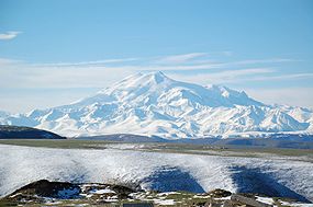
Elevation extremes
- Lowest point: Caspian SeaCaspian SeaThe Caspian Sea is the largest enclosed body of water on Earth by area, variously classed as the world's largest lake or a full-fledged sea. The sea has a surface area of and a volume of...
level: −28 m - Highest point: Mount ElbrusMount ElbrusMount Elbrus is an inactive volcano located in the western Caucasus mountain range, in Kabardino-Balkaria and Karachay-Cherkessia, Russia, near the border of Georgia. Mt. Elbrus's peak is the highest in the Caucasus, in Russia...
: 5,642 m