
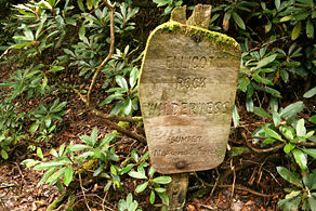
Ellicott Rock Wilderness
Encyclopedia
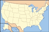
Georgia (U.S. state)
Georgia is a state located in the southeastern United States. It was established in 1732, the last of the original Thirteen Colonies. The state is named after King George II of Great Britain. Georgia was the fourth state to ratify the United States Constitution, on January 2, 1788...
, North Carolina
North Carolina
North Carolina is a state located in the southeastern United States. The state borders South Carolina and Georgia to the south, Tennessee to the west and Virginia to the north. North Carolina contains 100 counties. Its capital is Raleigh, and its largest city is Charlotte...
, and South Carolina
South Carolina
South Carolina is a state in the Deep South of the United States that borders Georgia to the south, North Carolina to the north, and the Atlantic Ocean to the east. Originally part of the Province of Carolina, the Province of South Carolina was one of the 13 colonies that declared independence...
come together. It is the only wilderness that straddles three states. Approximately 2021 acres (8.2 km²) are located in Georgia in the Chattahoochee National Forest, approximately 3394 acres (13.7 km²) are located in North Carolina in the Nantahala National Forest
Nantahala National Forest
The Nantahala National Forest, established in 1920, is a national forest located in the American state of North Carolina. The word "Nantahala" is a Cherokee word meaning "Land of the Noonday Sun." The name is appropriate as, in some spots, the sun only reaches the floors of the deep gorges of the...
, and approximately 2859 acres (11.6 km²) are located in South Carolina in the Andrew Pickens Ranger District of the Sumter National Forest
Sumter National Forest
The Sumter National Forest is one of two forests in South Carolina that are managed together by the United States Forest Service, the other being the Francis Marion National Forest. The Sumter National Forest consists of which are divided into several non-contiguous sections in western South...
. Bisecting the Wilderness is the Chattooga River
Chattooga River
The Chattooga River is the main tributary of the Tugaloo River. Its headwaters are located southwest of Cashiers, North Carolina, and it stretches to where it has its confluence with the Tallulah River within Lake Tugalo, held back by the Tugalo Dam...
, a Wild and Scenic River. The Wilderness is managed by the United States Forest Service
United States Forest Service
The United States Forest Service is an agency of the United States Department of Agriculture that administers the nation's 155 national forests and 20 national grasslands, which encompass...
and is part of the National Wilderness Preservation System
National Wilderness Preservation System
The National Wilderness Preservation System of the United States protects federally managed land areas designated for preservation in their natural condition. It was established by the Wilderness Act upon the signature of President Lyndon B. Johnson on September 3, 1964...
.
The Wilderness is named for “Ellicott's Rock
Ellicott's Rock
In 1811, Andrew Ellicott made a survey for the State of Georgia to resolve the boundary dispute between Georgia and North Carolina. He marked a large rock in the Chattooga River with "NC-GA", standing for North Carolina - Georgia....
,” a rock on the east bank of the Chattooga River on which surveyor Andrew Ellicott
Andrew Ellicott
Andrew Ellicott was a U.S. surveyor who helped map many of the territories west of the Appalachians, surveyed the boundaries of the District of Columbia, continued and completed Pierre Charles L'Enfant's work on the plan for Washington, D.C., and served as a teacher in survey methods for...
chiseled a mark in 1811 to determine the border between Georgia and North Carolina.
The highest elevation
Elevation
The elevation of a geographic location is its height above a fixed reference point, most commonly a reference geoid, a mathematical model of the Earth's sea level as an equipotential gravitational surface ....
in the Georgia portion of the Ellicott Rock Wilderness is the 3672 feet (1,119.2 m) summit of Glade Mountain
Glade Mountain
Glade Mountain, elevation , is the highest point in the Ellicott Rock Wilderness, which straddles Georgia, North Carolina and South Carolina. It is also in the Chattahoochee National Forest in Rabun County, Georgia.- References :**- External links :*...
, which is also the high point of the Wilderness. The Chattooga River drops from 2381 feet (725.7 m) to 2100 feet (640.1 m) as it flows through the Wilderness. Fork Mountain, elevation 3,294, is the highest point in the South Carolina portion of the Elliott Rock Wilderness and is the second-highest summit in South Carolina.
It was named to the National Register of Historical Places in 1973 - Object - #73001722.
External links
- US Forest Service entry for Ellicott Rock Wilderness
- Wilderness.net entry for the Ellicott Rock Wilderness
- GORP entry for the Ellicott Rock Wilderness
- Map of Ellicott Rock Wilderness
- Entry in Hiking the Carolinas for the Ellicott Rock Wilderness
- Sherpa Guide to the Ellicott Rock Wilderness
- TopoQuest Map showing location of Ellicott Rock