

Eldon Hill
Encyclopedia

Peak District
The Peak District is an upland area in central and northern England, lying mainly in northern Derbyshire, but also covering parts of Cheshire, Greater Manchester, Staffordshire, and South and West Yorkshire....
National Park in the county of Derbyshire
Derbyshire
Derbyshire is a county in the East Midlands of England. A substantial portion of the Peak District National Park lies within Derbyshire. The northern part of Derbyshire overlaps with the Pennines, a famous chain of hills and mountains. The county contains within its boundary of approx...
, England
England
England is a country that is part of the United Kingdom. It shares land borders with Scotland to the north and Wales to the west; the Irish Sea is to the north west, the Celtic Sea to the south west, with the North Sea to the east and the English Channel to the south separating it from continental...
four kilometres southwest of the village of Castleton. It is a grass-covered limestone
Limestone
Limestone is a sedimentary rock composed largely of the minerals calcite and aragonite, which are different crystal forms of calcium carbonate . Many limestones are composed from skeletal fragments of marine organisms such as coral or foraminifera....
hill which reaches a height of 470 metres (1542 feet). It is primarily pastureland and is used for rough grazing, although a large proportion of the hill has been lost to limestone quarrying. It lies within the Castleton Site of Special Scientific Interest
Site of Special Scientific Interest
A Site of Special Scientific Interest is a conservation designation denoting a protected area in the United Kingdom. SSSIs are the basic building block of site-based nature conservation legislation and most other legal nature/geological conservation designations in Great Britain are based upon...
. Eldon Hill was formed when a bed of pure limestone was squeezed and upfolded by geological forces to form a dome; it is the highest limestone hill north of the River Wye
River Wye, Derbyshire
The River Wye is a limestone river in the Peak District of Derbyshire, England. It is in length, and is one of the major tributaries of the River Derwent, which flows into the River Trent, and ultimately into the Humber and the North Sea....
.
The hill is of considerable geological, historical and industrial interest; it lies at the northern limit of the carboniferous
Carboniferous
The Carboniferous is a geologic period and system that extends from the end of the Devonian Period, about 359.2 ± 2.5 Mya , to the beginning of the Permian Period, about 299.0 ± 0.8 Mya . The name is derived from the Latin word for coal, carbo. Carboniferous means "coal-bearing"...
limestone in the Peak District, as further north it merges into the millstone grit
Gritstone
Gritstone or Grit is a hard, coarse-grained, siliceous sandstone. This term is especially applied to such sandstones that are quarried for building material. British gritstone was used for millstones to mill flour, to grind wood into pulp for paper and for grindstones to sharpen blades. "Grit" is...
of the Dark Peak
Dark Peak
The Dark Peak is the higher, wilder northern part of the Peak District in England.It gets its name because , the underlying limestone is covered by a cap of Millstone Grit which means that in winter the soil is almost always saturated with water...
. The hill's name comes from the Old English language
Old English language
Old English or Anglo-Saxon is an early form of the English language that was spoken and written by the Anglo-Saxons and their descendants in parts of what are now England and southeastern Scotland between at least the mid-5th century and the mid-12th century...
and means Elves Hill, as many years ago people believed that elves lived in the many potholes and caves on the hill. In 1285 the hill was called Elvedon.
The main feature of Eldon Hill which strikes all visitors is the amount of quarry
Quarry
A quarry is a type of open-pit mine from which rock or minerals are extracted. Quarries are generally used for extracting building materials, such as dimension stone, construction aggregate, riprap, sand, and gravel. They are often collocated with concrete and asphalt plants due to the requirement...
ing that has been done on the site. Quarrying permission was granted in 1950 and huge quantities of limestone have been excavated, mostly for road-building purposes. A large amount of the northern and northwestern slopes of the hill have disappeared and it has been called the best-known eyesore in the Peak District. In 1995 an application by RMC Aggregates to extend the quarrying further east was denied as parliament tightened up on environmental problems caused by old mineral permissions granted between 1948 and 1981. The quarry closed in 1999 and now stands unused with vegetation starting to grow on the quarry face. There have been some attempts at natural restoration with several aquatic pools being established in the former workings. The termination of quarrying has also given cavers
Caving
Caving—also occasionally known as spelunking in the United States and potholing in the United Kingdom—is the recreational pastime of exploring wild cave systems...
the chance to explore some of the narrow caves exposed by the work, with Sidetrack Cave being the most impressive.
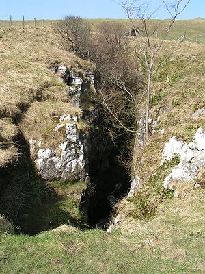
350 metres south of the summit lies Eldon Hole. At 55 metres it is the deepest pothole in the area and was named as one of the Seven Wonders of the Peak by the philosopher Thomas Hobbes
Thomas Hobbes
Thomas Hobbes of Malmesbury , in some older texts Thomas Hobbs of Malmsbury, was an English philosopher, best known today for his work on political philosophy...
in 1636. Close to the summit of the hill lies a Bronze Age
Bronze Age
The Bronze Age is a period characterized by the use of copper and its alloy bronze as the chief hard materials in the manufacture of some implements and weapons. Chronologically, it stands between the Stone Age and Iron Age...
tumulus
Tumulus
A tumulus is a mound of earth and stones raised over a grave or graves. Tumuli are also known as barrows, burial mounds, Hügelgrab or kurgans, and can be found throughout much of the world. A tumulus composed largely or entirely of stones is usually referred to as a cairn...
, a large burial site measuring 16 by 15 metres and 1.5 metres high. The tumulus has been excavated on several occasions with human skeletons and jewellery amongst the finds. The hill is dotted with numerous lead
Lead
Lead is a main-group element in the carbon group with the symbol Pb and atomic number 82. Lead is a soft, malleable poor metal. It is also counted as one of the heavy metals. Metallic lead has a bluish-white color after being freshly cut, but it soon tarnishes to a dull grayish color when exposed...
mines all of which are disused with many of them capped off for safety.
Eldon Hill can be climbed either from the villages of Peak Forest
Peak Forest
Peak Forest is a small village on the main road the from Chapel-en-le-Frith to Chesterfield in England.The village grew from the earlier settlement of Dam at the conjunction of Perrydale and Damdale. There is an inn, a village shop and a Primary School...
to the south or Castleton to the north. The approach from Castleton goes up Cave Dale
Cave Dale
Cave Dale is a dry limestone valley in the Derbyshire Peak District, England. It is located at grid reference . The northern end of the dale starts at the village of Castleton where the valley sides are almost perpendicular and over 50 metres in height...
with a return down Winnats Pass
Winnats Pass
Winnats Pass is in the High Peak area of the English county of Derbyshire. It lies to the west of the village of Castleton, in the National Trust's High Peak Estate. The road winds through a cleft, surrounded by towering limestone pinnacles...
to give a very interesting walk. The approach from Peak Forest is shorter and passes Eldon Hole on the way. The summit of the hill stands just 100 metres from the edge of the fenced quarry workings and gives good views with Mam Tor
Mam Tor
Mam Tor is a hill near Castleton in the High Peak of Derbyshire, England. Its name literally translates as Heights of the Mother and it is also known as the Shivering Mountain on account of the instability of its lower shale layers...
, Axe Edge Moor
Axe Edge Moor
Axe Edge Moor is the major moorland west of Buxton in the Peak District. It is mainly gritstone . Its highest point is at . This is slightly lower than Shining Tor .The moor is the source of the River Dove, River Manifold, River Dane, River Wye and River Goyt...
and the town of Buxton
Buxton
Buxton is a spa town in Derbyshire, England. It has the highest elevation of any market town in England. Located close to the county boundary with Cheshire to the west and Staffordshire to the south, Buxton is described as "the gateway to the Peak District National Park"...
all well seen.