
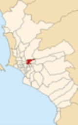
El Agustino
Encyclopedia
El Agustino is a district
of the Lima Province
in Peru
. It is part of city of Lima
.
Officially established as a district on January 6, 1965, the current mayor
(alcalde
) of El Agustino is Víctor Modesto Salcedo Ríos. The district's postal code
is 10.
of 12.54 km². Its administrative center is located 197 meters above sea level
. Originally the boundary with Ate was marked by the Río Surco irrigation ditch, but in 1989 the eastern part of El Agustino (east of the El Agustino hill, which gave the district its name) broke away to form Santa Anita district with the Santa Anita section of Ate and surrounding areas.
, the district has 166,177 inhabitants and a population density of 13,251.8 persons/km². In 1999, there were 32,910 households in the district. It is the 25th most populated district in Lima.
Districts of Peru
The districts of Peru are the third-level country subdivisions of Peru. They are subdivisions of the provinces, which in turn are subdivisions of the larger regions or departments...
of the Lima Province
Lima Province
Lima Province is located in the central coast of Peru and is the only province in the country not belonging to any of the twenty-five regions. Its capital is Lima, which is also the nation's capital....
in Peru
Peru
Peru , officially the Republic of Peru , is a country in western South America. It is bordered on the north by Ecuador and Colombia, on the east by Brazil, on the southeast by Bolivia, on the south by Chile, and on the west by the Pacific Ocean....
. It is part of city of Lima
Lima
Lima is the capital and the largest city of Peru. It is located in the valleys of the Chillón, Rímac and Lurín rivers, in the central part of the country, on a desert coast overlooking the Pacific Ocean. Together with the seaport of Callao, it forms a contiguous urban area known as the Lima...
.
Officially established as a district on January 6, 1965, the current mayor
Mayor
In many countries, a Mayor is the highest ranking officer in the municipal government of a town or a large urban city....
(alcalde
Alcalde
Alcalde , or Alcalde ordinario, is the traditional Spanish municipal magistrate, who had both judicial and administrative functions. An alcalde was, in the absence of a corregidor, the presiding officer of the Castilian cabildo and judge of first instance of a town...
) of El Agustino is Víctor Modesto Salcedo Ríos. The district's postal code
Postal code
A postal code is a series of letters and/or digits appended to a postal address for the purpose of sorting mail. Once postal codes were introduced, other applications became possible.In February 2005, 117 of the 190 member countries of the Universal Postal Union had postal code systems...
is 10.
Geography
The district has a total land areaArea
Area is a quantity that expresses the extent of a two-dimensional surface or shape in the plane. Area can be understood as the amount of material with a given thickness that would be necessary to fashion a model of the shape, or the amount of paint necessary to cover the surface with a single coat...
of 12.54 km². Its administrative center is located 197 meters above sea level
Sea level
Mean sea level is a measure of the average height of the ocean's surface ; used as a standard in reckoning land elevation...
. Originally the boundary with Ate was marked by the Río Surco irrigation ditch, but in 1989 the eastern part of El Agustino (east of the El Agustino hill, which gave the district its name) broke away to form Santa Anita district with the Santa Anita section of Ate and surrounding areas.
Boundaries
- North: San Juan de LuriganchoSan Juan de LuriganchoSan Juan de Lurigancho is a district in Lima, Peru, located in the area known as Cono Este. It is sometimes referred to as simple "SJL" on various forms of transportation...
and LuriganchoLuriganchoLurigancho-Chosica is a district of the Lima Province in Peru, located in the valley of the Rímac River which it shares with neighboring Chaclacayo and Ate districts. It was created on January 2, 1857. Its capital is the town of Chosica. The district has a total land area of 236.47 km²... - East: AteAte DistrictAte, also known as Ate-Vitarte, is a district of the Lima Province in Peru. Located in the eastern part of the province, it is one of the districts that comprise the city of Lima.-Geography:The district has a total land area of 77.72 km²...
and Santa AnitaSanta Anita DistrictSanta Anita is a district of the Lima Province in Peru. It is part of city of Lima.Officially established as a district on October 25, 1989 from parts of Ate and El Agustino separated by the Rio Surco, a ditch which went all the way to Santiago de Surco. The current mayor of Santa Anita is Osiris... - South: Ate, San LuisSan Luis District, LimaSan Luis is a district of the Lima Province in Peru. It is part of city of Lima.Officially established as a district on May 30, 1968, the current mayor of San Luis is Fernando Javier Durand Mejía. The district's postal code is 30....
, La VictoriaLa Victoria District, LimaLa Victoria is a district of the Lima Province in Peru and one of the districts that comprises the city of Lima. One of the most populous in Lima.... - West: Downtown LimaLima DistrictLima is a district of the Lima Province in Peru. It is not where the inner city zone of Lima, the country's capital city, is located, San Isidro District being such area in Lima....
Demographics
According to a 2002 estimate by the INEIInstituto Nacional de Estadística e Informática
The Instituto Nacional de Estadística e Informática is a semi-autonomous Peruvian government agency which coordinates, compiles, and evaluates statistical information for the country...
, the district has 166,177 inhabitants and a population density of 13,251.8 persons/km². In 1999, there were 32,910 households in the district. It is the 25th most populated district in Lima.
External links
- Municipalidad Distrital de El Agustino - El Agustino District Council Official Website