
Effigy Mounds National Monument
Encyclopedia
Effigy Mounds National Monument preserves three prehistoric sites in Allamakee County
and Clayton County, Iowa
in the midwestern United States
.
. They are contiguous and easily accessible. The Sny Magill
Unit (112 mounds) is approximately 11 miles (17.7 km) south of the other units, and offers no visitor facilities.
It forms the heart of a cluster of interrelated protected areas. It is adjacent to the Upper Mississippi River National Wildlife and Fish Refuge
, the Driftless Area National Wildlife Refuge
, the Yellow River State Forest
, and a short distance to the south, Pikes Peak State Park
. There are also a number of state-owned wildlife management areas, such as the one at Sny Magill Creek
, where Clayton County also maintains a county park.
 Prehistoric mounds are common from the plains of the Midwest to the Atlantic seaboard
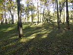
, but only in this general area was there a culture that regularly constructed mounds in the shape of mammals, birds, or reptiles. Mounds were usually constructed in single building episodes. First sod is removed from the ground in the shape of the effigy. Important people were to be buried the in the heart and head of the effigy. Finally earth was made into mounds over the shape.The monument contains 2526 acres (10.2 km²) with 206 mounds of which 31 are effigies. The Largest, Great Bear Mound, measures 42 meters from head to tail and rises over a meter above the original ground level. Human cultures have occupied this part of the country for so long. Historically, most of the Great Plains
to the west of the Mississippi River
was covered in grassland
s, which are very prone to fires that keep trees from becoming established. Here in extreme northeastern Iowa, the Effigy Mounds area was a point of transition between the eastern hardwood forests and the central prairies. Native American and early settlers would have been able to draw on natural resources available in forest
s, wetland
s, and prairie
s, making the site hospitable for humans for many centuries.
, located at the park entrance, contains museum exhibits highlighting archaeological and natural specimens, an auditorium and book sales outlet. The park has 14 miles of hiking trails. No paved public automobile access roads exist in the park. Rangers give guided hikes and prehistoric tool demonstrations that are scheduled and advertised, mid-June through Labor Day weekend. Educational programs are presented on- and off-site by appointment.
Natural features in the monument include forests, tallgrass prairie
s, wetlands and river
s. There are no lodging or camping facilities in the park. Excellent camping is available at nearby Pikes Peak State Park
and Yellow River State Forest
in Iowa; there is also Wyalusing State Park
in Wisconsin
. Various primitive campgrounds exist in the area as well. The national monument is quite close to the town of Marquette, Iowa
, and is just across the Mississippi River from the city of Prairie du Chien, Wisconsin
, where ample motel and gambling-boat facilities exist.
Effigy Mounds was proclaimed a National Monument
on October 25, 1949, largely because of the efforts of Charles R. Keyes
, head of the Iowa Archaeological Survey, and Ellison Orr, chief field supervisor for the Iowa Archaeological Survey.
. The adjacent Driftless Area National Wildlife Refuge takes its name from this region.
Allamakee County, Iowa
-2010 census:The 2010 census recorded a population of 14,330 in the county, with a population density of . There were 7,617 housing units, of which 5,845 were occupied.-2000 census:...
and Clayton County, Iowa
Clayton County, Iowa
-2010 census:The 2010 census recorded a population of 18,129 in the county, with a population density of . There were 8,999 housing units, of which 7,599 were occupied.-2000 census:...
in the midwestern United States
United States
The United States of America is a federal constitutional republic comprising fifty states and a federal district...
.
Mounds
The North Unit (67 mounds) and South Unit (29 mounds) are located where the counties meet along the Mississippi RiverMississippi River
The Mississippi River is the largest river system in North America. Flowing entirely in the United States, this river rises in western Minnesota and meanders slowly southwards for to the Mississippi River Delta at the Gulf of Mexico. With its many tributaries, the Mississippi's watershed drains...
. They are contiguous and easily accessible. The Sny Magill
Sny Magill Creek
Sny Magill Creek is a minor tributary of the Upper Mississippi River, rising in central Clayton County, Iowa and flowing to the Upper Mississippi River at Effigy Mounds National Monument in the vicinity of Marquette, Iowa. It has a drainage of . It is regarded as one of the best trout streams in...
Unit (112 mounds) is approximately 11 miles (17.7 km) south of the other units, and offers no visitor facilities.
It forms the heart of a cluster of interrelated protected areas. It is adjacent to the Upper Mississippi River National Wildlife and Fish Refuge
Upper Mississippi River National Wildlife and Fish Refuge
The Upper Mississippi River National Wildlife and Fish Refuge is a . 261 river mile long National Wildlife Refuge located in and along the Upper Mississippi River. It runs from Wabasha, Minnesota in the north to Rock Island, Illinois in the south....
, the Driftless Area National Wildlife Refuge
Driftless Area National Wildlife Refuge
Driftless Area National Wildlife Refuge is a United States National Wildlife Refuge in northeastern Iowa, southwestern Wisconsin and northwestern Illinois...
, the Yellow River State Forest
Yellow River State Forest
Yellow River State Forest is partly forested land owned by the Iowa Department of Natural Resources. It is located in the southeastern corner of Allamakee County, the most northeasterly of Iowa's counties...
, and a short distance to the south, Pikes Peak State Park
Pikes Peak State Park
Pikes Peak State Park is a state park of Iowa, USA, featuring a bluff overlooking the Upper Mississippi River opposite the confluence of the Wisconsin River. The park is operated by the Iowa Department of Natural Resources. It is nearly a thousand acres in extent. The nearest city is McGregor,...
. There are also a number of state-owned wildlife management areas, such as the one at Sny Magill Creek
Sny Magill Creek
Sny Magill Creek is a minor tributary of the Upper Mississippi River, rising in central Clayton County, Iowa and flowing to the Upper Mississippi River at Effigy Mounds National Monument in the vicinity of Marquette, Iowa. It has a drainage of . It is regarded as one of the best trout streams in...
, where Clayton County also maintains a county park.
Atlantic Seaboard
The Atlantic seaboard watershed is a watershed of North America along both*the Atlantic Canada coast south of the Gulf of Saint Lawrence Watershed &*the East Coast of the United States north of the watershed of the Okeechobee Waterway....
, but only in this general area was there a culture that regularly constructed mounds in the shape of mammals, birds, or reptiles. Mounds were usually constructed in single building episodes. First sod is removed from the ground in the shape of the effigy. Important people were to be buried the in the heart and head of the effigy. Finally earth was made into mounds over the shape.The monument contains 2526 acres (10.2 km²) with 206 mounds of which 31 are effigies. The Largest, Great Bear Mound, measures 42 meters from head to tail and rises over a meter above the original ground level. Human cultures have occupied this part of the country for so long. Historically, most of the Great Plains
Great Plains
The Great Plains are a broad expanse of flat land, much of it covered in prairie, steppe and grassland, which lies west of the Mississippi River and east of the Rocky Mountains in the United States and Canada. This area covers parts of the U.S...
to the west of the Mississippi River
Mississippi River
The Mississippi River is the largest river system in North America. Flowing entirely in the United States, this river rises in western Minnesota and meanders slowly southwards for to the Mississippi River Delta at the Gulf of Mexico. With its many tributaries, the Mississippi's watershed drains...
was covered in grassland
Grassland
Grasslands are areas where the vegetation is dominated by grasses and other herbaceous plants . However, sedge and rush families can also be found. Grasslands occur naturally on all continents except Antarctica...
s, which are very prone to fires that keep trees from becoming established. Here in extreme northeastern Iowa, the Effigy Mounds area was a point of transition between the eastern hardwood forests and the central prairies. Native American and early settlers would have been able to draw on natural resources available in forest
Forest
A forest, also referred to as a wood or the woods, is an area with a high density of trees. As with cities, depending where you are in the world, what is considered a forest may vary significantly in size and have various classification according to how and what of the forest is composed...
s, wetland
Wetland
A wetland is an area of land whose soil is saturated with water either permanently or seasonally. Wetlands are categorised by their characteristic vegetation, which is adapted to these unique soil conditions....
s, and prairie
Prairie
Prairies are considered part of the temperate grasslands, savannas, and shrublands biome by ecologists, based on similar temperate climates, moderate rainfall, and grasses, herbs, and shrubs, rather than trees, as the dominant vegetation type...
s, making the site hospitable for humans for many centuries.
Public access
The visitor centerVisitor center
A visitor center or centre , visitor information center, tourist information center, is a physical location that provides tourist information to the visitors who tour the place or area locally...
, located at the park entrance, contains museum exhibits highlighting archaeological and natural specimens, an auditorium and book sales outlet. The park has 14 miles of hiking trails. No paved public automobile access roads exist in the park. Rangers give guided hikes and prehistoric tool demonstrations that are scheduled and advertised, mid-June through Labor Day weekend. Educational programs are presented on- and off-site by appointment.
Natural features in the monument include forests, tallgrass prairie
Tallgrass prairie
The tallgrass prairie is an ecosystem native to central North America, with fire as its primary periodic disturbance. In the past, tallgrass prairies covered a large portion of the American Midwest, just east of the Great Plains, and portions of the Canadian Prairies. They flourished in areas with...
s, wetlands and river
River
A river is a natural watercourse, usually freshwater, flowing towards an ocean, a lake, a sea, or another river. In a few cases, a river simply flows into the ground or dries up completely before reaching another body of water. Small rivers may also be called by several other names, including...
s. There are no lodging or camping facilities in the park. Excellent camping is available at nearby Pikes Peak State Park
Pikes Peak State Park
Pikes Peak State Park is a state park of Iowa, USA, featuring a bluff overlooking the Upper Mississippi River opposite the confluence of the Wisconsin River. The park is operated by the Iowa Department of Natural Resources. It is nearly a thousand acres in extent. The nearest city is McGregor,...
and Yellow River State Forest
Yellow River State Forest
Yellow River State Forest is partly forested land owned by the Iowa Department of Natural Resources. It is located in the southeastern corner of Allamakee County, the most northeasterly of Iowa's counties...
in Iowa; there is also Wyalusing State Park
Wyalusing State Park
Wyalusing State Park is a Wisconsin state park at the confluence of the Mississippi and Wisconsin Rivers in the town of Wyalusing, just south of Prairie du Chien. Wyalusing means "home of the warrior" in the Lenape language spoken by Munsee-Delaware Indians who settled in the area in the 19th...
in Wisconsin
Wisconsin
Wisconsin is a U.S. state located in the north-central United States and is part of the Midwest. It is bordered by Minnesota to the west, Iowa to the southwest, Illinois to the south, Lake Michigan to the east, Michigan to the northeast, and Lake Superior to the north. Wisconsin's capital is...
. Various primitive campgrounds exist in the area as well. The national monument is quite close to the town of Marquette, Iowa
Marquette, Iowa
Marquette is a city in Clayton County, Iowa, United States. The population was 421 at the 2000 census. The city, which is located on the Mississippi River, is named after Jesuit missionary Jacques Marquette, who along with Louis Joliet discovered the Mississippi River just southeast of the city on...
, and is just across the Mississippi River from the city of Prairie du Chien, Wisconsin
Prairie du Chien, Wisconsin
Prairie du Chien is a city in and the county seat of Crawford County, Wisconsin, United States. The population was 5,911 at the 2010 census. Its Zip Code is 53821....
, where ample motel and gambling-boat facilities exist.
Effigy Mounds was proclaimed a National Monument
U.S. National Monument
A National Monument in the United States is a protected area that is similar to a National Park except that the President of the United States can quickly declare an area of the United States to be a National Monument without the approval of Congress. National monuments receive less funding and...
on October 25, 1949, largely because of the efforts of Charles R. Keyes
Charles R. Keyes
For the Iowa geologist, see Charles Rollin Keyes.Charles Reuben Keyes was a pioneering Iowa archaeologist, and linguist. He is best remembered as the founder of modern Iowa archaeology. While his early work dealt with lingusitcs, by the 1920s Keyes focused his research almost exclusively on...
, head of the Iowa Archaeological Survey, and Ellison Orr, chief field supervisor for the Iowa Archaeological Survey.
Driftless Area
The Effigy Mounds National Monument is also noted for being in the Driftless Area, an area of North America which escaped glaciation during the last ice ageWisconsin glaciation
The last glacial period was the most recent glacial period within the current ice age occurring during the last years of the Pleistocene, from approximately 110,000 to 10,000 years ago....
. The adjacent Driftless Area National Wildlife Refuge takes its name from this region.
- The Park Service writes that:
"Patchy remnants of Pre-Illinoian glacial driftMoraineA moraine is any glacially formed accumulation of unconsolidated glacial debris which can occur in currently glaciated and formerly glaciated regions, such as those areas acted upon by a past glacial maximum. This debris may have been plucked off a valley floor as a glacier advanced or it may have...
more than 500,000 years old recently have been discovered in the area. Unlike the rest of Iowa, the Paleozoic Plateau was bypassed by the last of the PleistocenePleistoceneThe Pleistocene is the epoch from 2,588,000 to 11,700 years BP that spans the world's recent period of repeated glaciations. The name pleistocene is derived from the Greek and ....
glaciers (the WisconsinWisconsin glaciationThe last glacial period was the most recent glacial period within the current ice age occurring during the last years of the Pleistocene, from approximately 110,000 to 10,000 years ago....
), allowing the region's fast cutting streams to expose and carve out deep channels in the bedrock-dominated terrain. The area is characterized by thin loessLoessLoess is an aeolian sediment formed by the accumulation of wind-blown silt, typically in the 20–50 micrometre size range, twenty percent or less clay and the balance equal parts sand and silt that are loosely cemented by calcium carbonate...
soil cover, isolated patches of glacial drift, deeply entrenched river valleys, and karstKARSTKilometer-square Area Radio Synthesis Telescope is a Chinese telescope project to which FAST is a forerunner. KARST is a set of large spherical reflectors on karst landforms, which are bowlshaped limestone sinkholes named after the Kras region in Slovenia and Northern Italy. It will consist of...
(sinkholeSinkholeA sinkhole, also known as a sink, shake hole, swallow hole, swallet, doline or cenote, is a natural depression or hole in the Earth's surface caused by karst processes — the chemical dissolution of carbonate rocks or suffosion processes for example in sandstone...
s, caveCaveA cave or cavern is a natural underground space large enough for a human to enter. The term applies to natural cavities some part of which is in total darkness. The word cave also includes smaller spaces like rock shelters, sea caves, and grottos.Speleology is the science of exploration and study...
s, and springs) topography."
See also
- Iowa archaeologyIowa archaeologyThe archaeology of Iowa is the study of the buried remains of human culture within the state of Iowa from the earliest prehistoric through the late historic periods. When the American Indians first arrived in what is now Iowa more than 13,000 years ago, they were hunters and gatherers living in a...
- Indians of IowaIndians of IowaIndians of Iowa include numerous Native American tribes which have lived in the state of Iowa historically and prehistorically:-Chewerean-Siouan speaking tribes from the prehistoric period:*Ho-Chunk...
- Indian Mounds ParkIndian Mounds ParkThe term Indian Mounds Park may refer to:* Beattie Park Mound Group - Rockford, Illinois* Effigy Mounds National Monument, Iowa* Indian Mound Park * Indian Mounds Park * Indian Mounds Park...
- List of burial mounds in the United States
External links
- Official NPS website: Effigy Mounds National Monument
- Sny Magill CreekSny Magill CreekSny Magill Creek is a minor tributary of the Upper Mississippi River, rising in central Clayton County, Iowa and flowing to the Upper Mississippi River at Effigy Mounds National Monument in the vicinity of Marquette, Iowa. It has a drainage of . It is regarded as one of the best trout streams in...
Unit coordinates: 42°56′26"N 91°10′0"W