
Echo Mountain
Encyclopedia
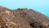
Echo Mountain is a summit on the Angeles National Forest
above Altadena, California
.
 Echo Mountain was shaped from an alluvial fan
between Rubio and Las Flores canyons. It is geographically defined by Castle Canyon to its leeward
side, Rubio Canyon at its foot, and Las Flores Canyon on its windward side. Echo has a mean elevation of 3207 feet (977 m) above sea level. It is most visible as a short mountain extension whose ridge protrudes below the peak of Inspiration Point.
Echo Mountain's name is derived from the number of repetitions one's voice could emit into Castle Canyon. Boy Scout projects were made to find the "sweet spot" where the largest number of repetitions could be heard. During the days of the Mount Lowe Railway
"echophones" were set up to assist in voice projections near the best sweet spots.
 On 6 January 1993, Echo Mountain, also referred to as Mount Echo, was delineated as part of the Mount Lowe Railway monument area listed by the U.S. Forest Service on the National Register of Historic Places
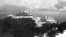
. On top of the mountain are the ruins of "White City", a resort along the scenic Mount Lowe Railway
, which could easily be seen from the valley below. From its point and down an incline to its foot in Rubio Canyon was the Great Incline funicular
of the Mount Lowe Railway, whose white cars could be seen ascending and descending Echo.
located at the top of Lake Avenue
, or via the fire road which extends from Millard Canyon to a point along the old right of way, which will lead to the backside of the promontory.
Angeles National Forest
The Angeles National Forest of the U.S. National Forest Service is located in the San Gabriel Mountains of Los Angeles County, southern California. It was established on July 1, 1908, incorporating the first San Bernardino National Forest and parts of the former Santa Barbara and San Gabriel...
above Altadena, California
Altadena, California
Altadena is an unincorporated area and census-designated place in Los Angeles County, California, United States, approximately from the downtown Los Angeles Civic Center, and directly north of the city of Pasadena, California...
.
Geography
Alluvial fan
An alluvial fan is a fan-shaped deposit formed where a fast flowing stream flattens, slows, and spreads typically at the exit of a canyon onto a flatter plain. A convergence of neighboring alluvial fans into a single apron of deposits against a slope is called a bajada, or compound alluvial...
between Rubio and Las Flores canyons. It is geographically defined by Castle Canyon to its leeward
Windward and leeward
Windward is the direction upwind from the point of reference. Leeward is the direction downwind from the point of reference. The side of a ship that is towards the leeward is its lee side. If the vessel is heeling under the pressure of the wind, this will be the "lower side"...
side, Rubio Canyon at its foot, and Las Flores Canyon on its windward side. Echo has a mean elevation of 3207 feet (977 m) above sea level. It is most visible as a short mountain extension whose ridge protrudes below the peak of Inspiration Point.
Echo Mountain's name is derived from the number of repetitions one's voice could emit into Castle Canyon. Boy Scout projects were made to find the "sweet spot" where the largest number of repetitions could be heard. During the days of the Mount Lowe Railway
Mount Lowe Railway
The Mount Lowe Railway was the third in a series of scenic mountain railroads in America created as a tourist attraction on Echo Mountain and Mount Lowe, north of Los Angeles, California. The railway, originally incorporated by Professor Thaddeus S. C. Lowe as the Pasadena & Mt. Wilson Railroad Co...
"echophones" were set up to assist in voice projections near the best sweet spots.
History
National Register of Historic Places
The National Register of Historic Places is the United States government's official list of districts, sites, buildings, structures, and objects deemed worthy of preservation...
. On top of the mountain are the ruins of "White City", a resort along the scenic Mount Lowe Railway
Mount Lowe Railway
The Mount Lowe Railway was the third in a series of scenic mountain railroads in America created as a tourist attraction on Echo Mountain and Mount Lowe, north of Los Angeles, California. The railway, originally incorporated by Professor Thaddeus S. C. Lowe as the Pasadena & Mt. Wilson Railroad Co...
, which could easily be seen from the valley below. From its point and down an incline to its foot in Rubio Canyon was the Great Incline funicular
Funicular
A funicular, also known as an inclined plane or cliff railway, is a cable railway in which a cable attached to a pair of tram-like vehicles on rails moves them up and down a steep slope; the ascending and descending vehicles counterbalance each other.-Operation:The basic principle of funicular...
of the Mount Lowe Railway, whose white cars could be seen ascending and descending Echo.
Trail access
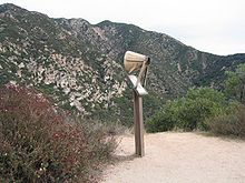
Echo Mountain can be reached by the Sam Merrill TrailSam Merrill Trail
The Sam Merrill Trail is a major hiking trail in the Las Flores Canyon of the San Gabriel Mountain Range north of Altadena, California which leads to the top of Echo Mountain. It was built by Charles Warner and the Forest Conservation Club of Pasadena during the 1930s...
located at the top of Lake Avenue
Lake Avenue (Pasadena)
Lake Avenue is a major north-south feeder road for the Pasadena and Altadena communities in Los Angeles County, California. The road was developed in the mid 19th century and takes its name from a lake which was located at its southern most end known variously as Mission Lake, Kewen Lake, and...
, or via the fire road which extends from Millard Canyon to a point along the old right of way, which will lead to the backside of the promontory.