
Eastern Idaho Railroad
Encyclopedia
Watco Companies
Watco Companies, Inc. is a Pittsburg, Kansas-based transportation company that was formed in 1983 by Charles R. Webb. Watco is composed of three divisions: transportation, mechanical and transloading. WCI is the owner of Watco Transportation Services, Inc...
(WAMX), of Pittsburg, Kansas
Pittsburg, Kansas
Pittsburg is a city in Crawford County, in southeastern Kansas, United States. It is the most populous city in Crawford County and in southeastern Kansas. As of the 2010 census, the city population was 20,233.-History:...
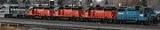
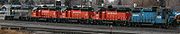
, a short line operator. EIRR operates two segments, that move more than 35,000 carloads per year to the Union Pacific, with interchanges at Idaho Falls on the Northern Segment, and Minidoka
Minidoka, Idaho
Minidoka is a city in Minidoka County, Idaho, United States. The population was 129 at the 2000 census. It is part of the Burley, Idaho Micropolitan Statistical Area....
on the Southern segment. The annual income is reported as being under 25 million dollars.
The Southern segment
The Southern lines consist of:- UP's former Twin Falls Branch (Minidoka to BuhlBuhl, IdahoBuhl is a city located on the old Oregon Trail in the western half of Twin Falls County, Idaho, United States. The population was 4,037 at the 2000 census. It is part of the Twin Falls, Idaho Micropolitan Statistical Area....
, 74 miles) - UP's former North Side Branch (RupertRupert, IdahoRupert is the county seat and largest city of Minidoka County, Idaho, United States. It is part of the Burley, Idaho Micropolitan Statistical Area...
to WendellWendell, IdahoWendell is a city in Gooding County, Idaho, United States. The population was 2,338 at the 2000 census.-Geography:Wendell is located at .According to the United States Census Bureau, the city has a total area of , all of it land....
, 57 miles) - the Raft River Industrial Lead (BurleyBurley, IdahoBurley is a city in Cassia and Minidoka counties in the southern portion of the U.S. state of Idaho. The population was 10,345 at the 2010 census. The city is the county seat of Cassia County....
to Declo, 9miles) - the Oakley Industrial Lead (Burley to Martin, 11 miles).
All lines connect for a total of 152 miles (244.6 km). Operations are based out of the ex-UP depots at Twin Falls
Twin Falls, Idaho
Twin Falls is the county seat and largest city of Twin Falls County, Idaho, United States. The population was 44,125 at the 2010 censusTwin Falls is the largest city of Idaho's Magic Valley region...
and Rupert. The southern segment interchanges with U.P. at Minidoka, Idaho.
The Northern Segment
The Northern lines consist of:- Union Pacific's former (Utah northern) main line in Idaho Falls (5 miles)
- the Yellowstone Branch (Idaho Falls to AshtonAshton, IdahoAshton is a city in Fremont County, Idaho, United States. It is part of the Rexburg, Idaho Micropolitan Statistical Area. The population was 1,129 at the 2000 census. The district is noted for seed potato production and bills itself as the world's largest seed potato growing area.-Geography and...
, 52 miles) - the St Anthony Industrial Lead (Saint AnthonySt. Anthony, IdahoSt. Anthony is a city in and the county seat of Fremont County, Idaho, United States. The population was 3,342 at the 2000 census. It is part of the Rexburg, Idaho Micropolitan Statistical Area.-Geography:St...
to Egin, 12 miles) - the Goshen Industrial Lead (AmmonAmmon, IdahoAmmon is a city in Bonneville County, Idaho, United States. As of the 2000 census the population of Ammon was 6,187, with an estimated 2006 population of 12,065.Having nearly doubled in size since 2000, Ammon is among the fastest-growing cities in Idaho...
to Lincoln Jct., 4 miles) - the East Belt Branch (Newdale to Orvin, 38 miles),
- the West Belt Industrial Lead (Ucon to Menan, 10 miles).
All lines connect for a total of 119 miles (191.5 km), served by four locomotives, with operations based out of an office trailer on the north end of the Idaho Falls yard, the point at which EIRR interchanges with UP's Montana
Montana
Montana is a state in the Western United States. The western third of Montana contains numerous mountain ranges. Smaller, "island ranges" are found in the central third of the state, for a total of 77 named ranges of the Rocky Mountains. This geographical fact is reflected in the state's name,...
sub.