

Eagle Creek
Encyclopedia
Stream
A stream is a body of water with a current, confined within a bed and stream banks. Depending on its locale or certain characteristics, a stream may be referred to as a branch, brook, beck, burn, creek, "crick", gill , kill, lick, rill, river, syke, bayou, rivulet, streamage, wash, run or...
in Hood River County
Hood River County, Oregon
-Demographics:As of the census of 2000, there were 20,411 people, 7,248 households, and 5,175 families residing in the county. The population density was 39 people per square mile . There were 7,818 housing units at an average density of 15 per square mile...
, Oregon
Oregon
Oregon is a state in the Pacific Northwest region of the United States. It is located on the Pacific coast, with Washington to the north, California to the south, Nevada on the southeast and Idaho to the east. The Columbia and Snake rivers delineate much of Oregon's northern and eastern...
, United States
United States
The United States of America is a federal constitutional republic comprising fifty states and a federal district...
. The creek drains into the Columbia River
Columbia River
The Columbia River is the largest river in the Pacific Northwest region of North America. The river rises in the Rocky Mountains of British Columbia, Canada, flows northwest and then south into the U.S. state of Washington, then turns west to form most of the border between Washington and the state...
in Multnomah County
Multnomah County, Oregon
Multnomah County is one of 36 counties in the U.S. state of Oregon. Though smallest in area, it is the most populous as its county seat, Portland, is the state's largest city...
, with its outlet on the Columbia River Gorge
Columbia River Gorge
The Columbia River Gorge is a canyon of the Columbia River in the Pacific Northwest of the United States. Up to deep, the canyon stretches for over as the river winds westward through the Cascade Range forming the boundary between the State of Washington to the north and Oregon to the south...
. It is in the Mount Hood National Forest
Mount Hood National Forest
The Mount Hood National Forest is located east of the city of Portland, Oregon, and the northern Willamette River valley. The Forest extends south from the Columbia River Gorge across more than of forested mountains, lakes and streams to the Olallie Scenic Area, a high lake basin under the slopes...
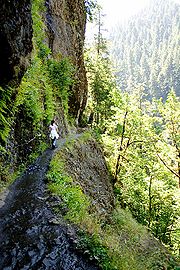
. The Eagle Creek Trail – the most popular trail in the Gorge – follows the creek.
Tunnel Falls and Punch Bowl Falls
Punch Bowl Falls
Punch Bowl Falls are a group of famous waterfalls on Eagle Creek in Hood River County, Oregon, United States. Eagle Creek drains into the Columbia River, with its outlet on the Columbia River Gorge in Multnomah County....
, located on Eagle Creek, are remote and scenic waterfall
Waterfall
A waterfall is a place where flowing water rapidly drops in elevation as it flows over a steep region or a cliff.-Formation:Waterfalls are commonly formed when a river is young. At these times the channel is often narrow and deep. When the river courses over resistant bedrock, erosion happens...
s along the creek. The Historic Columbia River Highway crosses the creek's outlet to the Columbia River
Columbia River
The Columbia River is the largest river in the Pacific Northwest region of North America. The river rises in the Rocky Mountains of British Columbia, Canada, flows northwest and then south into the U.S. state of Washington, then turns west to form most of the border between Washington and the state...
. A substantial hike through some occasionally rough terrain is required to get to the creek's namesake waterfall.
Punch Bowl Falls has been featured in inspirational posters and other media (see illustration below).
Eagle Creek Trail was built by the CCC
Civilian Conservation Corps
The Civilian Conservation Corps was a public work relief program that operated from 1933 to 1942 in the United States for unemployed, unmarried men from relief families, ages 18–25. A part of the New Deal of President Franklin D...
and WPA
Works Progress Administration
The Works Progress Administration was the largest and most ambitious New Deal agency, employing millions of unskilled workers to carry out public works projects, including the construction of public buildings and roads, and operated large arts, drama, media, and literacy projects...
in the 1930s for the Pacific Crest Trail
Pacific Crest Trail
The Pacific Crest Trail is a long-distance mountain hiking and equestrian trail on the Western Seaboard of the United States. The southern terminus is at the California border with Mexico...
, probably to cross the Columbia River at Bonneville Dam
Bonneville Dam
Bonneville Lock and Dam consists of several run-of-the-river dam structures that together complete a span of the Columbia River between the U.S. states of Oregon and Washington at River Mile 146.1. The dam is located east of Portland, Oregon, in the Columbia River Gorge. The primary functions of...
. The PCT was rerouted to its current route some 1.5 miles (2.4 km) further east sometime by the early 1970s to connect with the Bridge of the Gods
Bridge of the Gods (modern structure)
The Bridge of the Gods is a steel truss cantilever bridge that spans the Columbia River between Cascade Locks, Oregon and Washington state near North Bonneville. It is approximately 40 miles east of Portland, Oregon and 4 miles upriver from the Bonneville Dam...
across the Columbia River.
- Eagle Creek 45.640556°N 121.9325°W
- Eagle Creek Trail 45.5725°N 121.820556°W