
Downs Link
Encyclopedia
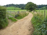
The Downs Link is a 36.7-mile (58.7 km) footpath and bridleway linking the North Downs Way
at St. Martha's Hill
in Surrey
with the South Downs Way
near Steyning
in West Sussex
and on via the Coastal Link to Shoreham-by-Sea
.
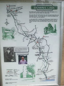 The Downs Link follows for much of its route the course of two dismantled railways - the Cranleigh Line
and the Steyning Line
- both of which closed in the 1960s as a result of the Beeching Axe
. Between 1965 and 1970 the track was lifted and much of the track ballast
was removed. The coppiced woodland along many of the cuttings and embankment sides remained unmanaged until 2 April 1970 when ownership of much of the track was sold by the British Railways Board
to Surrey County Council
and Hambleton Rural District Council (which became Waverley Borough Council in 1974) for £17,500. The local authorities managed the land until 1984, clearing scrub to allow the general public to use it as a recreational facility.
In 1984, the local authorities working together with other authorities and the Manpower Services Commission established the Downs Link, a 30 miles (48.3 km) long footpath and bridleway connecting the North
and South Downs
National Trails. The Link was opened on 9 July 1984 by the Mayor of Waverley, Anne Hoath, at Baynards station; it subsequently received a commendation in the National Conservation Award Scheme jointly organised by The Times
newspaper and the Royal Institution of Chartered Surveyors
.
, but a trail of regional importance supported by three local authorities - Surrey County Council, West Sussex County Council and Waverley Borough Council.
The route of the Link deviates from the original railway alignment between Slinfold
and Christ's Hospital for some two miles (3 km) where a section of the old line has been sold to an adjacent landowner. Attempts to establish a right of way across this section have been resisted by the owner, and the Link is re-routed along the main road. Nevertheless, another missing section in the Downs Link was filled in April 2007 with the granting of a new right of way from Baystone Bridge, along the route of the old railway line, to a point near Christ's Hospital station.
North Downs Way
The North Downs Way is a long-distance path in southern England, opened in 1978. It runs from Farnham to Dover, past Godalming, Guildford, Dorking, Merstham, Otford and Rochester, along the Surrey Hills Area of Outstanding Natural Beauty and Kent Downs AONB.East of Boughton Lees, the path splits...
at St. Martha's Hill
St. Martha's Hill
St Martha's Hill is a landmark of the parish of St Martha's in Surrey, England, situated between Guildford and Chilworth, Surrey. It is a prominent hill on the Greensand Ridge just to the south of the North Downs in southeast England. The top of the hill provides good views of Newland's Corner and...
in Surrey
Surrey
Surrey is a county in the South East of England and is one of the Home Counties. The county borders Greater London, Kent, East Sussex, West Sussex, Hampshire and Berkshire. The historic county town is Guildford. Surrey County Council sits at Kingston upon Thames, although this has been part of...
with the South Downs Way
South Downs Way
The South Downs Way is a long distance footpath and bridleway running along the South Downs in southern England, and is one of 15 National Trails in England and Wales...
near Steyning
Steyning
Steyning is a small town and civil parish in the Horsham District of West Sussex, England. It is located at the north end of the River Adur gap in the South Downs, four miles north of Shoreham-by-Sea...
in West Sussex
West Sussex
West Sussex is a county in the south of England, bordering onto East Sussex , Hampshire and Surrey. The county of Sussex has been divided into East and West since the 12th century, and obtained separate county councils in 1888, but it remained a single ceremonial county until 1974 and the coming...
and on via the Coastal Link to Shoreham-by-Sea
Shoreham-by-Sea
Shoreham-by-Sea is a small town, port and seaside resort in West Sussex, England. Shoreham-by-Sea railway station is located less than a mile from the town centre and London Gatwick Airport is away...
.
History
Cranleigh Line
The Cranleigh Line was a short railway line that connected Guildford, the county town of Surrey, with the West Sussex market town of Horsham, via Cranleigh, a distance of 19¼ miles...
and the Steyning Line
Steyning Line
The Steyning Line was a railway line that connected the West Sussex market town of Horsham with the once bustling south-coast port of Shoreham-by-Sea, with the possibility of an onward connection to Brighton...
- both of which closed in the 1960s as a result of the Beeching Axe
Beeching Axe
The Beeching Axe or the Beeching Cuts are informal names for the British Government's attempt in the 1960s to reduce the cost of running British Railways, the nationalised railway system in the United Kingdom. The name is that of the main author of The Reshaping of British Railways, Dr Richard...
. Between 1965 and 1970 the track was lifted and much of the track ballast
Track ballast
Track ballast forms the trackbed upon which railway sleepers or railroad ties are laid. It is packed between, below, and around the ties. It is used to facilitate drainage of water, to distribute the load from the railroad ties, and also to keep down vegetation that might interfere with the track...
was removed. The coppiced woodland along many of the cuttings and embankment sides remained unmanaged until 2 April 1970 when ownership of much of the track was sold by the British Railways Board
British Railways Board
The British Railways Board was a nationalised industry in the United Kingdom that existed from 1962 to 2001. From its foundation until 1997, it was responsible for most railway services in Great Britain, trading under the brand names British Railways and, from 1965, British Rail...
to Surrey County Council
Surrey County Council
Surrey County Council is the county council that governs the non-metropolitan county of Surrey in England. The council is composed of 80 elected councillors.The council is controlled by the Conservative party.The leader of the council is David Hodge....
and Hambleton Rural District Council (which became Waverley Borough Council in 1974) for £17,500. The local authorities managed the land until 1984, clearing scrub to allow the general public to use it as a recreational facility.
In 1984, the local authorities working together with other authorities and the Manpower Services Commission established the Downs Link, a 30 miles (48.3 km) long footpath and bridleway connecting the North
North Downs Way
The North Downs Way is a long-distance path in southern England, opened in 1978. It runs from Farnham to Dover, past Godalming, Guildford, Dorking, Merstham, Otford and Rochester, along the Surrey Hills Area of Outstanding Natural Beauty and Kent Downs AONB.East of Boughton Lees, the path splits...
and South Downs
South Downs Way
The South Downs Way is a long distance footpath and bridleway running along the South Downs in southern England, and is one of 15 National Trails in England and Wales...
National Trails. The Link was opened on 9 July 1984 by the Mayor of Waverley, Anne Hoath, at Baynards station; it subsequently received a commendation in the National Conservation Award Scheme jointly organised by The Times
The Times
The Times is a British daily national newspaper, first published in London in 1785 under the title The Daily Universal Register . The Times and its sister paper The Sunday Times are published by Times Newspapers Limited, a subsidiary since 1981 of News International...
newspaper and the Royal Institution of Chartered Surveyors
Royal Institution of Chartered Surveyors
The Royal Institution of Chartered Surveyors is an independent, representative professional body which regulates property professionals and surveyors in the United Kingdom and other sovereign nations....
.
Present day
The Downs Link is not a National Trail within the meaning of the National Parks and Access to the Countryside Act 1949National Parks and Access to the Countryside Act 1949
The National Parks and Access to the Countryside Act 1949 is an Act of the Parliament of the United Kingdom which created the National Parks Commission which later became the Countryside Commission and then the Countryside Agency, which became Natural England when it merged with English Nature in...
, but a trail of regional importance supported by three local authorities - Surrey County Council, West Sussex County Council and Waverley Borough Council.
The route of the Link deviates from the original railway alignment between Slinfold
Slinfold
Slinfold is a village and civil parish in the Horsham District of West Sussex, England. It lies just off the A29 road 3.4 miles west of Horsham.The parish has a land area of 1695 hectares...
and Christ's Hospital for some two miles (3 km) where a section of the old line has been sold to an adjacent landowner. Attempts to establish a right of way across this section have been resisted by the owner, and the Link is re-routed along the main road. Nevertheless, another missing section in the Downs Link was filled in April 2007 with the granting of a new right of way from Baystone Bridge, along the route of the old railway line, to a point near Christ's Hospital station.
External links
- West Sussex County Council Page
- Downs Link: A Six Stage Route Guide (2009)
- Downs Link: A Six Stage Route Guide (2003)
- Downs Link (West Sussex County Council)
- The Downs Link Route Map
- Downs Link - General Information