
Dove Holes
Encyclopedia
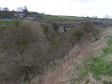
Dove Holes is a village in the High Peak district of Derbyshire
, England
. It has a population of about 1,200. It straddles the A6 road and it lies three miles from Buxton
and three miles from Chapel-en-le-Frith
. Trains run from Dove Holes railway station
into Manchester
.
Residents of the village live either in the village or on outlying farms. There are around six farms in the village and many more within the boundaries of the parish. There are also large limestone quarries that, over the years, have made an important contribution to the development and economy of the village. Additionally, there are several businesses, a general store and a post office
. There are two public house
s, one of which offers accommodation. There is a daily milk delivery service and a mobile library every fortnight. There is a church, Methodist chapel and a community centre. The village lies on the fringe of the Peak District National Park.
Evidence of human occupation at Dove Holes can be traced back to the Neolithic
Period (late Stone Age
) because of the existence of a henge
, known locally as The Bull Ring
, and an adjoining tumulus
. In medieval times the area was used as the royal hunting Forest of High Peak
(now known as Peak Forest
), an area set aside as a royal hunting forest
. The village's name is believed to derive from the Celtic word dwfr (dwr in modern Welsh
), which means water, hence Water Holes or Dove Holes. The same word is the origin of the name 'Dover
' for the famous Channel
ferryport.
In 1650, a General Survey of the Manor of High Peak was made to assess the property of the late King Charles
. This recorded that people were burning limestone around the village and that there were 14 kilns thereabouts, the burnt lime (quicklime) being slaked and used by farmers to condition the soil in their fields. At that time, lime kilns could be built and demolished without authority.
With the coming of the Industrial Revolution
, and the opening of the Peak Forest Tramway
in 1796, the limestone quarries were commercialised. The first of these was at nearby Loads Knowl and others quickly followed along Dove Holes Dale. Undoubtedly, the opening of the Peak Forest Tramway and the consequent expansion of commercial limestone quarries contributed greatly to the expansion of the village. For the first time, there was an outlet for limestone in Manchester
via the Peak Forest Tramway, Bugsworth Basin
, the Peak Forest Canal
and the Ashton Canal
.
There is a Trent Barton
bus garage on the east side of the A6, replacing the one which used to be in Buxton.
In 2001, the village was voted the Ugliest Village in Britain.
Cemex
operate a quarry in Dove Holes.
Derbyshire
Derbyshire is a county in the East Midlands of England. A substantial portion of the Peak District National Park lies within Derbyshire. The northern part of Derbyshire overlaps with the Pennines, a famous chain of hills and mountains. The county contains within its boundary of approx...
, England
England
England is a country that is part of the United Kingdom. It shares land borders with Scotland to the north and Wales to the west; the Irish Sea is to the north west, the Celtic Sea to the south west, with the North Sea to the east and the English Channel to the south separating it from continental...
. It has a population of about 1,200. It straddles the A6 road and it lies three miles from Buxton
Buxton
Buxton is a spa town in Derbyshire, England. It has the highest elevation of any market town in England. Located close to the county boundary with Cheshire to the west and Staffordshire to the south, Buxton is described as "the gateway to the Peak District National Park"...
and three miles from Chapel-en-le-Frith
Chapel-en-le-Frith
Chapel-en-le-Frith is a small town in Derbyshire, England, on the edge of the Peak District near the border with Cheshire, from Manchester. Dubbed "The Capital of the Peak District", the settlement was established by the Normans in the 12th century, originally as a hunting lodge within the Forest...
. Trains run from Dove Holes railway station
Dove Holes railway station
Dove Holes railway station serves the village of Dove Holes, Derbyshire, England. The station is on the Manchester Piccadilly to Buxton line 37 km Dove Holes railway station serves the village of Dove Holes, Derbyshire, England. The station is on the Manchester Piccadilly to Buxton line...
into Manchester
Manchester
Manchester is a city and metropolitan borough in Greater Manchester, England. According to the Office for National Statistics, the 2010 mid-year population estimate for Manchester was 498,800. Manchester lies within one of the UK's largest metropolitan areas, the metropolitan county of Greater...
.
Residents of the village live either in the village or on outlying farms. There are around six farms in the village and many more within the boundaries of the parish. There are also large limestone quarries that, over the years, have made an important contribution to the development and economy of the village. Additionally, there are several businesses, a general store and a post office
Post office
A post office is a facility forming part of a postal system for the posting, receipt, sorting, handling, transmission or delivery of mail.Post offices offer mail-related services such as post office boxes, postage and packaging supplies...
. There are two public house
Public house
A public house, informally known as a pub, is a drinking establishment fundamental to the culture of Britain, Ireland, Australia and New Zealand. There are approximately 53,500 public houses in the United Kingdom. This number has been declining every year, so that nearly half of the smaller...
s, one of which offers accommodation. There is a daily milk delivery service and a mobile library every fortnight. There is a church, Methodist chapel and a community centre. The village lies on the fringe of the Peak District National Park.
Evidence of human occupation at Dove Holes can be traced back to the Neolithic
Neolithic
The Neolithic Age, Era, or Period, or New Stone Age, was a period in the development of human technology, beginning about 9500 BC in some parts of the Middle East, and later in other parts of the world. It is traditionally considered as the last part of the Stone Age...
Period (late Stone Age
Stone Age
The Stone Age is a broad prehistoric period, lasting about 2.5 million years , during which humans and their predecessor species in the genus Homo, as well as the earlier partly contemporary genera Australopithecus and Paranthropus, widely used exclusively stone as their hard material in the...
) because of the existence of a henge
Henge
There are three related types of Neolithic earthwork which are all sometimes loosely called henges. The essential characteristic of all three types is that they feature a ring bank and ditch but with the ditch inside the bank rather than outside...
, known locally as The Bull Ring
The Bull Ring
The Bull Ring is a Class II henge that was built in the late Neolithic period near Dove Holes in Derbyshire, England.It has coordinates , and is National Monument number 23282...
, and an adjoining tumulus
Tumulus
A tumulus is a mound of earth and stones raised over a grave or graves. Tumuli are also known as barrows, burial mounds, Hügelgrab or kurgans, and can be found throughout much of the world. A tumulus composed largely or entirely of stones is usually referred to as a cairn...
. In medieval times the area was used as the royal hunting Forest of High Peak
Forest of High Peak
The Forest of High Peak was, in medieval times, a moorland forest covering most of the North West of Derbyshire, in England as far south as Tideswell and Buxton....
(now known as Peak Forest
Peak Forest
Peak Forest is a small village on the main road the from Chapel-en-le-Frith to Chesterfield in England.The village grew from the earlier settlement of Dam at the conjunction of Perrydale and Damdale. There is an inn, a village shop and a Primary School...
), an area set aside as a royal hunting forest
Royal forest
A royal forest is an area of land with different meanings in England, Wales and Scotland; the term forest does not mean forest as it is understood today, as an area of densely wooded land...
. The village's name is believed to derive from the Celtic word dwfr (dwr in modern Welsh
Welsh language
Welsh is a member of the Brythonic branch of the Celtic languages spoken natively in Wales, by some along the Welsh border in England, and in Y Wladfa...
), which means water, hence Water Holes or Dove Holes. The same word is the origin of the name 'Dover
Dover
Dover is a town and major ferry port in the home county of Kent, in South East England. It faces France across the narrowest part of the English Channel, and lies south-east of Canterbury; east of Kent's administrative capital Maidstone; and north-east along the coastline from Dungeness and Hastings...
' for the famous Channel
English Channel
The English Channel , often referred to simply as the Channel, is an arm of the Atlantic Ocean that separates southern England from northern France, and joins the North Sea to the Atlantic. It is about long and varies in width from at its widest to in the Strait of Dover...
ferryport.
In 1650, a General Survey of the Manor of High Peak was made to assess the property of the late King Charles
Charles I of England
Charles I was King of England, King of Scotland, and King of Ireland from 27 March 1625 until his execution in 1649. Charles engaged in a struggle for power with the Parliament of England, attempting to obtain royal revenue whilst Parliament sought to curb his Royal prerogative which Charles...
. This recorded that people were burning limestone around the village and that there were 14 kilns thereabouts, the burnt lime (quicklime) being slaked and used by farmers to condition the soil in their fields. At that time, lime kilns could be built and demolished without authority.
With the coming of the Industrial Revolution
Industrial Revolution
The Industrial Revolution was a period from the 18th to the 19th century where major changes in agriculture, manufacturing, mining, transportation, and technology had a profound effect on the social, economic and cultural conditions of the times...
, and the opening of the Peak Forest Tramway
Peak Forest Tramway
The Peak Forest Tramway was an early horse- and gravity-powered industrial railway system in Derbyshire, England. Opened for trade on 31 August 1796, it remained in operation until the 1920s. Much of the route and the structures associated with the line remain...
in 1796, the limestone quarries were commercialised. The first of these was at nearby Loads Knowl and others quickly followed along Dove Holes Dale. Undoubtedly, the opening of the Peak Forest Tramway and the consequent expansion of commercial limestone quarries contributed greatly to the expansion of the village. For the first time, there was an outlet for limestone in Manchester
Manchester
Manchester is a city and metropolitan borough in Greater Manchester, England. According to the Office for National Statistics, the 2010 mid-year population estimate for Manchester was 498,800. Manchester lies within one of the UK's largest metropolitan areas, the metropolitan county of Greater...
via the Peak Forest Tramway, Bugsworth Basin
Bugsworth Basin
Bugsworth Basin is a canal basin at the terminus of the Peak Forest Canal. It is located at Buxworth in the valley of the Black Brook, close to Whaley Bridge...
, the Peak Forest Canal
Peak Forest Canal
The Peak Forest Canal, is a narrow locked artificial waterway in northern England. It is long and forms part of the connected English/Welsh inland waterway network.-General description:...
and the Ashton Canal
Ashton Canal
The Ashton Canal is a canal built in Greater Manchester in North West England.-Route:The Ashton leaves the Rochdale Canal at Ducie St. Junction in central Manchester, and climbs for through 18 locks, passing through Ancoats, Holt Town, Bradford-with-Beswick, Clayton, Openshaw, Droylsden,...
.
There is a Trent Barton
Trent Barton
Trent Barton is one of the very small number of significant independent bus operators in the United Kingdom. It was formed as the result of merging Derbyshire's Trent Buses with Nottinghamshire's Barton Transport....
bus garage on the east side of the A6, replacing the one which used to be in Buxton.
In 2001, the village was voted the Ugliest Village in Britain.
Cemex
Cemex
CEMEX is the world's largest building materials supplier and third largest cement producer. Founded in Mexico in 1906, the company is based in Monterrey, Mexico...
operate a quarry in Dove Holes.