

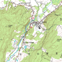
Digital raster graphic
Encyclopedia
Digital image
A digital image is a numeric representation of a two-dimensional image. Depending on whether or not the image resolution is fixed, it may be of vector or raster type...
resulting from scanning a paper USGS topographic map
Topographic map
A topographic map is a type of map characterized by large-scale detail and quantitative representation of relief, usually using contour lines in modern mapping, but historically using a variety of methods. Traditional definitions require a topographic map to show both natural and man-made features...
for use on a computer. DRGs created by USGS are typically scanned at 250 dpi
DPI
DPI may stand for* Dots per inch, a measure of printing resolution* Dhaka Polytechnic Institute, an educational institution of Bangladesh* Death Pact International, one of the first open source musical concept projects...
and saved as a TIFF. The raster
Raster graphics
In computer graphics, a raster graphics image, or bitmap, is a data structure representing a generally rectangular grid of pixels, or points of color, viewable via a monitor, paper, or other display medium...
image usually includes the original border information, referred to as the "map collar". The map file is UTM projected
Map projection
A map projection is any method of representing the surface of a sphere or other three-dimensional body on a plane. Map projections are necessary for creating maps. All map projections distort the surface in some fashion...
and georeference
Georeference
To georeference something means to define its existence in physical space. That is, establishing its location in terms of map projections or coordinate systems. The term is used both when establishing the relation between raster or vector images and coordinates, and when determining the spatial...
d to the surface of the earth. DRG's are regularly used in GIS
Geographic Information System
A geographic information system, geographical information science, or geospatial information studies is a system designed to capture, store, manipulate, analyze, manage, and present all types of geographically referenced data...
applications.
External links
- Libre Map ProjectLibre Map ProjectThe Libre Map Project is an online collection of all digital USGS 1:24K scale topographic maps covering the United States, available as a free download....
- USGS Sites
- Kentucky Raster Graphics Image Download Center
- Montana State Library Digital Raster Graphics download page
- Pennsylvania Spatial Data AccessPennsylvania Spatial Data AccessPennsylvania Spatial Data Access is Pennsylvania's official public access geospatial information clearinghouse.PASDA was developed as a research and outreach program by the Pennsylvania State University as a service to the citizens, governments, and businesses of the Commonwealth...
sites - [ftp://www.pasda.psu.edu/pub/pasda/other_states/wv/drg24k FTP site, DRGs for West Virginia (free)]
- [ftp://www.pasda.psu.edu/pub/pasda/other_states/ny/drg24k FTP site, DRGs for New York (free)]
- [ftp://www.pasda.psu.edu/pub/pasda/other_states/va/drg24k FTP site, DRGs for Virginia (free)]
- [ftp://www.pasda.psu.edu/pub/pasda/other_states/md/drg24k FTP site, DRGs for Maryland (free)]
- [ftp://www.pasda.psu.edu/pub/pasda/other_states/dc/drg24k FTP site, DRGs for Washington DC (free)]
- [ftp://www.pasda.psu.edu/pub/pasda/other_states/de/drg24k FTP site, DRGs for Delaware (free)]
- [ftp://www.pasda.psu.edu/pub/pasda/other_states/nc/drg24k FTP site, DRGs for North Carolina (free)]
- Texas Natural Resources Information SystemTexas Natural Resources Information SystemThe Texas Natural Resources Information System is the principal state archive in Texas for natural resources data. TNRIS provides a central access point for Texas Natural Resources data, census data, digital and paper maps, and information about datasets collected by state agencies and other...