

Texas Natural Resources Information System
Encyclopedia
The Texas Natural Resources Information System (TNRIS) is the principal state archive in Texas
for natural resources data. TNRIS provides a central access point for Texas Natural Resources data, census data, digital and paper maps, and information about datasets collected by state agencies and other organizations. TNRIS is a division of the Texas Water Development Board (TWDB) and receives guidance from the Texas Geographic Information Council (TGIC).
The staff includes individuals trained in the natural, computer and library sciences. TNRIS supplies data to government, academia, private sector, and to the public.
The TNRIS offices are located in the Stephen F. Austin Building, 1700 North Congress Avenue, in Austin, Texas.
TNRIS is a division of the Texas Water Development Board (TWDB). The TWDB receives advice on the operation of TNRIS from the Texas Geographic Information Council (TGIC), a geographic data planning and coordination group serving state and regional government agencies in the State of Texas. TGIC also advises the Executive Director of the Department of Information Resources on statewide rules and guidelines for agency use of geographic information technologies.
 The Research and Distribution Center (RDC) provides research materials and assistance in
locating maps, reports, and information. The Research Center collection includes aerial photographs,
USGS topographic maps, wetlands maps, Census maps and reports, and water resources
records.
Aerial Photographs
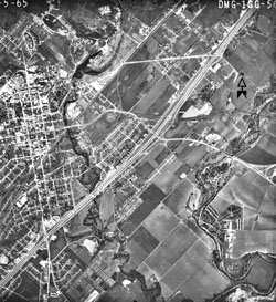
TNRIS has a large collection of remotely sensed imagery from various sources that is available to researchers and to the public. Holdings include photographs from the Texas Department of Transportation, the USDA-SCS, the USGS, NASA and private aerial survey companies. These aerial photos span several decades and can be used for historical change analysis. The collection (over 600,000 photos) contains predominantly black-and-white prints. The photography archive is open to the public, but materials must be used and copied in-house. RDC staff are scanning this valuable aerial photo collection and will make it available on CD-ROM and on the Internet.
Maps
TNRIS holdings include many types of federal, state, and specialized maps. TNRIS serves as a repository and distribution center for USGS topographic maps, National Wetlands Inventory (NWI) maps, current FEMA flood hazard maps, river basin and aquifer maps, well driller’s maps, and historic topographic maps. The current series of USGS topographic maps for Texas can be purchased from TNRIS. Historic topographic maps, FEMA maps, land use maps, and wetland maps can be used for research in-house or sent out to be copied. River basin, aquifer, and well driller’s maps are produced on demand. TNRIS’ collection of historic aerial photos are being scanned and made available in digital format. RDC staff assists customers with research projects, fills map orders, and arranges photocopying and reproduction services.
 Unlike the archival and clearinghouse activities of other TNRIS branches, the main function of The Texas Strategic Mapping Program (StratMap) is to create data for public distribution. StratMap manages the production and maintenance of seven high-resolution digital data layers for each of the 4376 7.5-minute quadrangles covering Texas. The statewide datasets include 1:12,000 scale color infrared orthoimagery, 1:24,000 scale digital elevation models and 1:24,000 scale digitized hypsography (elevation contours and spot elevations), hydrography (flowing water, water bodies and marshlands), soils (NRCS Soil Survey Geographic Data Base coverages), transportation (streets, roads, railroads and pipelines) and boundaries (counties, city limits, federal lands, state parks). Through StratMap, Texans receive the most comprehensive and highest quality statewide base mapping data layers available in the USA. With the completion of phase 1 data layers, the second phase of StratMap continues to locate, acquire, and produce geospatial data layers in support of spatial analyses and mapping efforts in the State of Texas.
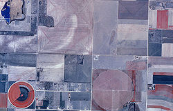
Currently, Stratmap has engaged in a collaborative partnership among state agencies and several technical contributing partners with interest in creating a new statewide aerial map for Texas. The project is based on a partnership with the U.S. Department of Agriculture Farm Services Agency and Texas. The images are acquired by airborne digital cameras and controlled by global positioning systems. Specialized processing removes optical distortions and assembles all of the images into a unified mapping coordinate system. This production process creates an image which has all of the utility of a map. The processed images are referenced to a USGS coordinate grid system and made available as individual image map files. All of these images are in the public domain and available from TNRIS and the Farm Services Agency. The project is also breaking new ground in producing imagery that will have one-half meter resolution which is twice as much detail as previously acquired for the state.
The StratMap statewide transportation dataset is a publicly available digital data layer which serves as a cartographic product for seamless basemap production.
StratMap Transportation
The StratMap political boundary dataset contains: Political jurisdictions, City boundaries, County boundaries, State boundaries and federal parks, Landmark boundaries (airports, universities, wildlife refuges, and military bases)
Political Boundaries
The 1:24,000 National Hydrography Dataset (NHD), jointly developed by the US Geological Survey (USGS) and the Environmental Protection Agency (EPA), is a hydrologic data network designed to show all surface water features including rivers and streams, ponds and lakes, springs, canals, wetlands, and shorelines.
Hydrography - NHD
The elevation data consists of vector contours and other raster based elevation dataset, e.g. DEMs, NED, and LiDAR
Elevation
The SSURGO
dataset was developed in partnership with the Natural Resources Conservation Service (NRCS) and is an updated digital version of the county soil surveys.
Elevation
National Agriculture Imagery Program
A Digital Orthophoto Quadrangle (DOQ) is a digital mapping product that combines the geometric qualities of a map with the detail of an aerial photograph. DOQs are digitally derived aerial photos that have been corrected so image distortion caused by perspective, camera tilt, and terrain relief are removed. Distances, bearings, and area calculations can all be measured on DOQs.
DOQQ
The BIC provides a catalog of data and information, several Internet websites, listings of data available through the center, and a newsletter to promote data sharing and discuss border-related issues. BIC staff conduct an ongoing inventory of borderlands geospatial data and information about environmental projects. An outreach function of BIC is sponsorship of border meetings and symposia, as well as workshops and presentations on border environmental issues. The geographic area covered is approximately 100 kilometers either side of the Rio Grande in Texas and Mexico. Data include water quality, level and streamflow, meteorological reports,
paper and digital maps, aerial photos and satellite imagery, and census publications.
Borderlands Center
FEMA's Map modernization Program officially ended with FY08 mapping assignments and did not map the entire state. The purpose of the Floodplain Mapping group within TNRIS is to work with its partners and support a program to increase local awareness and ownership of flood hazard maps. This effort will result in homeowners, business owners, State and local government officials, and other citizens of Texas receiving more accurate flood hazard and risk information. This process will start with taking a look at floodplain mapping needs statewide. The Texas Floodplain Mapping Needs tool has been developed to aid in the collection of those needs. Other efforts will be underway soon.
Oversight of the HPIDS contracting process is administered by the Texas Water Development Board in conjunction with the Texas Natural Resources Information System—the state's clearinghouse for digital maps and geographic data. The Texas contract is the first in the country to have the following combination of characteristics:
A pool of qualified providers with common agreement to state quality standards, delivering the latest technology and services at competitive cost.
State competition statutes have been met through this advertisement and selection method, giving state and local agencies an expedited path to purchasing.
Integrated statement of work structure allows for individual projects to be defined and prioritized against a single master contract.
Increased coordination of state efforts in acquisition of authoritative sources of geographic data.
This new Texas geographic information system (GIS) procurement model enhances the ability of the state to coordinate effectively with federal, regional and municipal governments and to actively manage geographic data resources as freely shared and integrated information. All public agencies will be engaged to share plans and information to combine funding, obtain volume discounts, and coordinate standardized products.
Texas
Texas is the second largest U.S. state by both area and population, and the largest state by area in the contiguous United States.The name, based on the Caddo word "Tejas" meaning "friends" or "allies", was applied by the Spanish to the Caddo themselves and to the region of their settlement in...
for natural resources data. TNRIS provides a central access point for Texas Natural Resources data, census data, digital and paper maps, and information about datasets collected by state agencies and other organizations. TNRIS is a division of the Texas Water Development Board (TWDB) and receives guidance from the Texas Geographic Information Council (TGIC).
History
TNRIS was established by the Legislature in 1968 as the Texas Water-Oriented Data Bank. In 1972, after four years of growth and diversification, it was renamed the Texas Natural Resources Information System. The mission of TNRIS is to provide a "centralized information system incorporating all Texas natural resource data, socioeconomic data related to natural resources, and indexes related to that data that are collected by state agencies or other entities." (Texas Water Code, 16.021).The staff includes individuals trained in the natural, computer and library sciences. TNRIS supplies data to government, academia, private sector, and to the public.
The TNRIS offices are located in the Stephen F. Austin Building, 1700 North Congress Avenue, in Austin, Texas.
TNRIS is a division of the Texas Water Development Board (TWDB). The TWDB receives advice on the operation of TNRIS from the Texas Geographic Information Council (TGIC), a geographic data planning and coordination group serving state and regional government agencies in the State of Texas. TGIC also advises the Executive Director of the Department of Information Resources on statewide rules and guidelines for agency use of geographic information technologies.
Research and distribution
locating maps, reports, and information. The Research Center collection includes aerial photographs,
USGS topographic maps, wetlands maps, Census maps and reports, and water resources
records.
Aerial Photographs
TNRIS has a large collection of remotely sensed imagery from various sources that is available to researchers and to the public. Holdings include photographs from the Texas Department of Transportation, the USDA-SCS, the USGS, NASA and private aerial survey companies. These aerial photos span several decades and can be used for historical change analysis. The collection (over 600,000 photos) contains predominantly black-and-white prints. The photography archive is open to the public, but materials must be used and copied in-house. RDC staff are scanning this valuable aerial photo collection and will make it available on CD-ROM and on the Internet.
Maps
TNRIS holdings include many types of federal, state, and specialized maps. TNRIS serves as a repository and distribution center for USGS topographic maps, National Wetlands Inventory (NWI) maps, current FEMA flood hazard maps, river basin and aquifer maps, well driller’s maps, and historic topographic maps. The current series of USGS topographic maps for Texas can be purchased from TNRIS. Historic topographic maps, FEMA maps, land use maps, and wetland maps can be used for research in-house or sent out to be copied. River basin, aquifer, and well driller’s maps are produced on demand. TNRIS’ collection of historic aerial photos are being scanned and made available in digital format. RDC staff assists customers with research projects, fills map orders, and arranges photocopying and reproduction services.
StratMap
Currently, Stratmap has engaged in a collaborative partnership among state agencies and several technical contributing partners with interest in creating a new statewide aerial map for Texas. The project is based on a partnership with the U.S. Department of Agriculture Farm Services Agency and Texas. The images are acquired by airborne digital cameras and controlled by global positioning systems. Specialized processing removes optical distortions and assembles all of the images into a unified mapping coordinate system. This production process creates an image which has all of the utility of a map. The processed images are referenced to a USGS coordinate grid system and made available as individual image map files. All of these images are in the public domain and available from TNRIS and the Farm Services Agency. The project is also breaking new ground in producing imagery that will have one-half meter resolution which is twice as much detail as previously acquired for the state.
Transportation
The StratMap statewide transportation dataset is a publicly available digital data layer which serves as a cartographic product for seamless basemap production.
StratMap Transportation
Political Boundaries
The StratMap political boundary dataset contains: Political jurisdictions, City boundaries, County boundaries, State boundaries and federal parks, Landmark boundaries (airports, universities, wildlife refuges, and military bases)
Political Boundaries
Hydrography - NHD
The 1:24,000 National Hydrography Dataset (NHD), jointly developed by the US Geological Survey (USGS) and the Environmental Protection Agency (EPA), is a hydrologic data network designed to show all surface water features including rivers and streams, ponds and lakes, springs, canals, wetlands, and shorelines.
Hydrography - NHD
Elevation (Hypsography/Digital Elevation Models/LiDAR)
The elevation data consists of vector contours and other raster based elevation dataset, e.g. DEMs, NED, and LiDAR
LIDAR
LIDAR is an optical remote sensing technology that can measure the distance to, or other properties of a target by illuminating the target with light, often using pulses from a laser...
Elevation
Soil Survey Geographic Dataset (SSURGO)
The SSURGO
SSURGO
SSURGO refers to digital soils data produced and distributed by the Natural Resources Conservation Service - National Cartography and Geospatial Center ....
dataset was developed in partnership with the Natural Resources Conservation Service (NRCS) and is an updated digital version of the county soil surveys.
Elevation
National Agriculture Imagery ProgramNational Agriculture Imagery ProgramThe National Agriculture Imagery Program acquires aerial imagery during the agricultural growing seasons in the continental United States...
(NAIP) and DOQQ Imagery
A Digital Orthophoto Quadrangle (DOQ) is a digital mapping product that combines the geometric qualities of a map with the detail of an aerial photograph. DOQs are digitally derived aerial photos that have been corrected so image distortion caused by perspective, camera tilt, and terrain relief are removed. Distances, bearings, and area calculations can all be measured on DOQs.
DOQQ
Borderlands Information Center
The Texas/Mexico Borderlands Information Center (BIC) is a central repository, dissemination, and referral center for natural resource and census data covering both sides of the Texas/Mexico border region. It also promotes closer ties, communication, and data sharing among agencies involved in border issues to reduce redundant data collection and project activities. The BIC is supported by the EPA, which provides funding for a full-time staff member, data purchases, and other expenditures needed to operate the Center and establish contacts in Mexico. The aim of the BIC is to be thoroughly binational in scope and to encourage a free interchange of data and information among institutions on both sides of the border.The BIC provides a catalog of data and information, several Internet websites, listings of data available through the center, and a newsletter to promote data sharing and discuss border-related issues. BIC staff conduct an ongoing inventory of borderlands geospatial data and information about environmental projects. An outreach function of BIC is sponsorship of border meetings and symposia, as well as workshops and presentations on border environmental issues. The geographic area covered is approximately 100 kilometers either side of the Rio Grande in Texas and Mexico. Data include water quality, level and streamflow, meteorological reports,
paper and digital maps, aerial photos and satellite imagery, and census publications.
Borderlands Center
National Flood Insurance Program (NFIP)
Texas Water Development Board became a Cooperating Technical Partner with FEMA in October 2000. In the 80th State Legislature the TWDB was named the state agency tasked with coordinating the National Flood Insurance Program (NFIP) within the state in 2007. The NFIP and Floodplain mapping is administered by the Texas Water Development Board and in conjunction with the Texas Natural Resources Information System-the state's clearinghouse for digital maps and geographic data.FEMA's Map modernization Program officially ended with FY08 mapping assignments and did not map the entire state. The purpose of the Floodplain Mapping group within TNRIS is to work with its partners and support a program to increase local awareness and ownership of flood hazard maps. This effort will result in homeowners, business owners, State and local government officials, and other citizens of Texas receiving more accurate flood hazard and risk information. This process will start with taking a look at floodplain mapping needs statewide. The Texas Floodplain Mapping Needs tool has been developed to aid in the collection of those needs. Other efforts will be underway soon.
High Priority Imagery and Data Sets (HPIDS)
The Council on Competitive Government , has established a new procurement process designed to strengthen Texas' capabilities to create and maintain digital maps for government entities and the public. This new process was established through the use of a state master contract referred to as High Priority Imagery and Data Sets (HPIDS). High priority data sets are digital map layers used for emergency management, economic development and as a resource in making informed policy decisions.Oversight of the HPIDS contracting process is administered by the Texas Water Development Board in conjunction with the Texas Natural Resources Information System—the state's clearinghouse for digital maps and geographic data. The Texas contract is the first in the country to have the following combination of characteristics:
A pool of qualified providers with common agreement to state quality standards, delivering the latest technology and services at competitive cost.
State competition statutes have been met through this advertisement and selection method, giving state and local agencies an expedited path to purchasing.
Integrated statement of work structure allows for individual projects to be defined and prioritized against a single master contract.
Increased coordination of state efforts in acquisition of authoritative sources of geographic data.
This new Texas geographic information system (GIS) procurement model enhances the ability of the state to coordinate effectively with federal, regional and municipal governments and to actively manage geographic data resources as freely shared and integrated information. All public agencies will be engaged to share plans and information to combine funding, obtain volume discounts, and coordinate standardized products.
External links
- www.tnris.org Official Agency Site
- Texas Water Development Board Parent Agency