

Diamante River
Encyclopedia
Argentina
Argentina , officially the Argentine Republic , is the second largest country in South America by land area, after Brazil. It is constituted as a federation of 23 provinces and an autonomous city, Buenos Aires...
province
Provinces of Argentina
Argentina is subdivided into twenty-three provinces and one autonomous city...
of Mendoza
Mendoza Province
The Province of Mendoza is a province of Argentina, located in the western central part of the country in the Cuyo region. It borders to the north with San Juan, the south with La Pampa and Neuquén, the east with San Luis, and to the west with the republic of Chile; the international limit is...
. It is born from glacier
Glacier
A glacier is a large persistent body of ice that forms where the accumulation of snow exceeds its ablation over many years, often centuries. At least 0.1 km² in area and 50 m thick, but often much larger, a glacier slowly deforms and flows due to stresses induced by its weight...
s on the Maipo
Maipo (volcano)
Maipo is a stratovolcano in the Andes, lying on the border between Argentina and Chile. It is located south of Tupungato and about southeast of Santiago....
, a volcano in the Andes
Andes
The Andes is the world's longest continental mountain range. It is a continual range of highlands along the western coast of South America. This range is about long, about to wide , and of an average height of about .Along its length, the Andes is split into several ranges, which are separated...
range in the Argentine–Chile
Chile
Chile ,officially the Republic of Chile , is a country in South America occupying a long, narrow coastal strip between the Andes mountains to the east and the Pacific Ocean to the west. It borders Peru to the north, Bolivia to the northeast, Argentina to the east, and the Drake Passage in the far...
an border, and flows east until emptying in the Desaguadero River
Desaguadero River
The Desaguadero River is the general name of a river in western Argentina that receives a number of different names on its path of 1,515 kilometres, with its most important section named Desaguadero proper.-Spring:...
. Its drainage basin
Drainage basin
A drainage basin is an extent or an area of land where surface water from rain and melting snow or ice converges to a single point, usually the exit of the basin, where the waters join another waterbody, such as a river, lake, reservoir, estuary, wetland, sea, or ocean...
covers an area of 2,750 km² in the central region of Mendoza.
The Diamante is fed by ice-thaw-fed streams that flow into its source, the Diamante Lake. It has an average flow of 33 m³/s, with its maximum during the spring and summer; the October–March period accounts for 70% of the annual water volume.
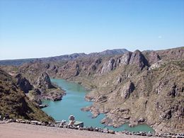
The upper course of the river turns south and then back north, and becomes entrenched
Entrenched river
An entrenched river is a river that is confined to a canyon or gorge, usually with a relatively narrow width and little or no flood plain, and often with meanders worn into the landscape...
within the deep, narrow Agua del Toro Canyon, where it is dam
Dam
A dam is a barrier that impounds water or underground streams. Dams generally serve the primary purpose of retaining water, while other structures such as floodgates or levees are used to manage or prevent water flow into specific land regions. Hydropower and pumped-storage hydroelectricity are...
med to produce hydroelectricity
Hydroelectricity
Hydroelectricity is the term referring to electricity generated by hydropower; the production of electrical power through the use of the gravitational force of falling or flowing water. It is the most widely used form of renewable energy...
by the Agua del Toro Dam, at about 69° W, and a few kilometres later by the Los Reyunos Dam
Los Reyunos Dam
The Los Reyunos Dam is a dam on the Diamante River, in central Mendoza Province, Argentina, some twenty-two miles from the city of San Rafael. The dam, built of stone and compacted clay to minimize execution and cost, is 440 feet high and contains a reservoir covering an area of 1,828 acres .The...
. Together these two power station
Power station
A power station is an industrial facility for the generation of electric energy....
s generate 500 MW
Watt
The watt is a derived unit of power in the International System of Units , named after the Scottish engineer James Watt . The unit, defined as one joule per second, measures the rate of energy conversion.-Definition:...
.
Upon reaching the plain, the Diamante loses part of its volume through infiltration and evaporation. It turns in a gentle arc, passing south of the city of San Rafael
San Rafael, Mendoza
San Rafael is a city in the southern region of the Mendoza Province, Argentina. With more than 170,000 inhabitants , it is the largest city and the seat of San Rafael Department....
, in the geographical center of Mendoza, where it is used for irrigation
Irrigation
Irrigation may be defined as the science of artificial application of water to the land or soil. It is used to assist in the growing of agricultural crops, maintenance of landscapes, and revegetation of disturbed soils in dry areas and during periods of inadequate rainfall...
(together with the Atuel River
Atuel River
The Atuel River is a river located mainly in the south of the Argentine province of Mendoza, with its last part in La Pampa. It is a tributary of the Desaguadero River....
).
The river splits in multiple branches shortly before reaching the Desaguadero (here called Salado), on the border with the province of San Luis
San Luis Province
San Luis is a province of Argentina located near the geographical center of the country . Neighboring provinces are, from the north clockwise, La Rioja, Córdoba, La Pampa, Mendoza and San Juan.-History:...
.