
.gif)
Deep River (North Carolina)
Encyclopedia
Cape Fear River
The Cape Fear River is a long blackwater river in east central North Carolina in the United States. It flows into the Atlantic Ocean near Cape Fear, from which it takes its name. The overall water quality of the river is continuously measured and monitored by and conducted by the , , and the...
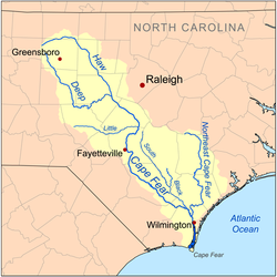
, approximately 125 miles (200 km) long, in north central North Carolina
North Carolina
North Carolina is a state located in the southeastern United States. The state borders South Carolina and Georgia to the south, Tennessee to the west and Virginia to the north. North Carolina contains 100 counties. Its capital is Raleigh, and its largest city is Charlotte...
in the United States
United States
The United States of America is a federal constitutional republic comprising fifty states and a federal district...
.
Course
It rises in the piedmontPiedmont (United States)
The Piedmont is a plateau region located in the eastern United States between the Atlantic Coastal Plain and the main Appalachian Mountains, stretching from New Jersey in the north to central Alabama in the south. The Piedmont province is a physiographic province of the larger Appalachian division...
country in western Guilford County
Guilford County, North Carolina
Guilford County is a county located in the U.S. state of North Carolina. In 2010, the Census Bureau estimated the county's population to be 491,230. Its seat is Greensboro. Since 1938, an additional county court has been located in High Point, North Carolina, making Guilford one of only a handful...
, east of Kernersville
Kernersville, North Carolina
Kernersville is a town in Forsyth County in the U.S. state of North Carolina. The population was 17,126 at the 2000 census. In 2007 the U.S. Census estimated the town's population at 22,309. Kernersville is located at the heart of the Piedmont Triad metropolitan area, which consists of the cities...
. It flows southeast past High Point
High Point, North Carolina
High Point is a city located in the Piedmont Triad region of North Carolina. As of 2010 the city had a total population of 104,371, according to the US Census Bureau. High Point is currently the eighth-largest municipality in North Carolina....
and Randleman
Randleman, North Carolina
Randleman is a city in Randolph County, North Carolina, United States. The population was 3,557 at the 2000 census. It is the home of NASCAR's Petty family, the Richard Petty Museum, and the Victory Junction Gang Camp.-Geography:...
, forming the Randleman Lake
Randleman Lake
Randleman Lake is a reservoir on the Deep River in Randolph and Guilford Counties in central North Carolina, extending from just northwest of Randleman to east of High Point. The lake was created in 2004 with the construction of the Randleman Lake Dam...
. It passes northeast of Asheboro
Asheboro, North Carolina
Asheboro is a city in Randolph County, North Carolina, United States. The population was 21,672 at the 2000 census. It is the county seat of Randolph County, and is the home of the state-owned North Carolina Zoo.-Geography:...
, then flows east to Franklinville
Franklinville, North Carolina
Franklinville is a town in Randolph County, North Carolina, United States. The population was 1,258 at the 2000 census.-Geography:Franklinville is located at ....
then to Ramseur
Ramseur, North Carolina
Ramseur is a town in Randolph County, North Carolina, United States. The population was 1,589 at the 2000 census.-Geography:Ramseur is located at ....
, then passing north of Sanford
Sanford, North Carolina
Sanford is a city in Lee County, North Carolina, United States. The population was 23,220 at the 2000 census. It is the county seat of Lee County.-Geography:Sanford is located at ....
. It joins Haw River
Haw River
The Haw River is a tributary of the Cape Fear River, approximately 110 mi long, that is entirely contained in north central North Carolina in the United States...
near Haywood
Haywood, North Carolina
Haywood is an unincorporated community in southeastern Chatham County, North Carolina, United States. Haywood was one of the sites considered in 1792 as a possible location for North Carolina's new capital, although Raleigh was ultimately chosen....
, just below the Haw's emergence from Jordan Lake
Jordan Lake
B. Everett Jordan Lake is a reservoir located west of Raleigh and south of Durham in Chatham County, North Carolina, in the United States of America. The northernmost end of the lake actually reaches into southwestern Durham County...
, to form the Cape Fear River
Cape Fear River
The Cape Fear River is a long blackwater river in east central North Carolina in the United States. It flows into the Atlantic Ocean near Cape Fear, from which it takes its name. The overall water quality of the river is continuously measured and monitored by and conducted by the , , and the...
.
Dams
The river has 12 dams or relict dam structures and is the source river of the Randleman lake project that covers 3000 acres (12 km²) of property on the river near U.S. Route 220U.S. Route 220
U.S. Route 220 is a long U.S. Route in the eastern United States.US 220 is a spur route of U.S. Route 20 but at present, the two routes do not intersect nor do they connect via other spurs of US 20. The former U. S. Route 120, which was signed in Pennsylvania between 1926 and 1967, intersected...
. The river crosses the fall line
Fall line
A fall line is a geomorphologic unconformity between an upland region of relatively hard crystalline basement rock and a coastal plain of softer sedimentary rock. A fall line is typically prominent when crossed by a river, for there will often be rapids or waterfalls...
of North Carolina, an area where rivers are quite rocky and have a moderately high gradient. This gradient was used to power mills along the river to support the early textile
Textile
A textile or cloth is a flexible woven material consisting of a network of natural or artificial fibres often referred to as thread or yarn. Yarn is produced by spinning raw fibres of wool, flax, cotton, or other material to produce long strands...
industry in North Carolina. The river, popular with canoe
Canoe
A canoe or Canadian canoe is a small narrow boat, typically human-powered, though it may also be powered by sails or small electric or gas motors. Canoes are usually pointed at both bow and stern and are normally open on top, but can be decked over A canoe (North American English) or Canadian...
ists, was a center of a great deal of activity during the American Revolution
American Revolution
The American Revolution was the political upheaval during the last half of the 18th century in which thirteen colonies in North America joined together to break free from the British Empire, combining to become the United States of America...
at places such as Franklinville and the House In The Horseshoe.
Until recently, the Deep River was host to the Carbonton Dam, the largest dam on the river at 17 feet (5.2 m) high and 270 feet (82 m) wide. In the fall of 2005, the dam was removed for the purpose of creating environmental mitigation
Environmental mitigation
Environmental mitigation, compensatory mitigation, or mitigation banking, are terms used primarily by the United States government and the related environmental industry to describe projects or programs intended to offset known impacts to an existing historic or natural resource such as a stream,...
credit by Restoration Systems, LLC, a leading environmental mitigation company in North Carolina. The project, which restored 10 miles (16 km) of the former impoundment around the House in the Horseshoe to free-flowing river, requires the company to monitor the Deep River for five years in order to document ecological and water chemistry changes as result of the removal.