

D'Entrecasteaux Islands
Encyclopedia
New Guinea
New Guinea is the world's second largest island, after Greenland, covering a land area of 786,000 km2. Located in the southwest Pacific Ocean, it lies geographically to the east of the Malay Archipelago, with which it is sometimes included as part of a greater Indo-Australian Archipelago...
in the Solomon Sea
Solomon Sea
The Solomon Sea is a sea located within the Pacific Ocean. It lies between Papua New Guinea and the Solomon Islands. Many major battles were fought there during World War II.-Extent:...
in Milne Bay Province
Milne Bay Province
Milne Bay is a province of Papua New Guinea. Its capital is Alotau. The province covers 14,000 km² of land and 252,990 km² of sea, within the province there are more than 600 islands, about 160 of which are inhabited...
of Papua New Guinea
Papua New Guinea
Papua New Guinea , officially the Independent State of Papua New Guinea, is a country in Oceania, occupying the eastern half of the island of New Guinea and numerous offshore islands...
. The group spans a distance of 160 km, has a total land area of approximately 3,100 km² and is separated from the Papua New Guinea mainland by the 30 km wide Ward Hunt Strait
Ward Hunt Strait
The Ward Hunt Strait is a 30 km wide stretch of water separating Papua New Guinea from Goodenough Island in the D'Entrecasteaux Islands. The Dart Reefs are located in the centre of the channel....
in the north and the 18 km wide Goschen Strait in the south. D'Entrecasteaux Islands show signs of volcanism
Volcanism
Volcanism is the phenomenon connected with volcanoes and volcanic activity. It includes all phenomena resulting from and causing magma within the crust or mantle of a planet to rise through the crust and form volcanic rocks on the surface....
.
People
The inhabitants of D'Entrecasteaux Islands are indigenous subsistence horticulturalistsHorticulture
Horticulture is the industry and science of plant cultivation including the process of preparing soil for the planting of seeds, tubers, or cuttings. Horticulturists work and conduct research in the disciplines of plant propagation and cultivation, crop production, plant breeding and genetic...
living in small, traditional settlements. People of this area produced and traded clay pots as well as participated in the Kula
Kula ring
Kula, also known as the kula exchange or kula ring, is a ceremonial exchange system conducted in the Milne Bay Province of Papua New Guinea.The Kula ring spans 18 island communities of the Massim archipelago, including the Trobriand Islands...
exchange of shell valuables, travelling widely to other islands on sea-going sailing canoes. During the more recent past, people harvested copra
Copra
Copra is the dried meat, or kernel, of the coconut. Coconut oil extracted from it has made copra an important agricultural commodity for many coconut-producing countries. It also yields coconut cake which is mainly used as feed for livestock.-Production:...
, trochus
Trochus
Trochus is a genus of medium-sized to very large sea snails. They are marine gastropod molluscs in the family Trochidae, the top snails....
and pearlshells and some timber for cash. Alluvial gold mining was once important and in recent years the area has been subject to mineral
Mining
Mining is the extraction of valuable minerals or other geological materials from the earth, from an ore body, vein or seam. The term also includes the removal of soil. Materials recovered by mining include base metals, precious metals, iron, uranium, coal, diamonds, limestone, oil shale, rock...
exploration.
Description
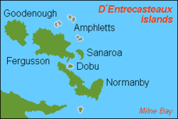
Goodenough Island
Goodenough Island in the Solomon Sea is the westernmost of the three large islands of the D'Entrecasteaux Islands in Milne Bay Province of Papua New Guinea. It lies to the east of mainland New Guinea and south west of the Trobriand Islands.It should not be confused with Goodenough's Island...
(Nidula), then across Moresby Straight to Fergusson
Fergusson Island
Fergusson Island is the largest island of the D'Entrecasteaux Islands, in Papua New Guinea. It has an area of just over 500 square miles , and mostly consists of mountainous regions, covered by rain forests...
(Moratau), the largest of the three, and across Dawson Straight to Normanby (Duau). In addition there are numerous small islands and reefs. Sanaroa
Sanaroa Island
Sanaroa Island is an island, part of D'Entrecasteaux Islands in Papua New Guinea, located east of Fergusson Island in Milne Bay Province, at .-Education:...
and Dobu
Dobu Island
Dobu Island is an island, part of D'Entrecasteaux Islands in Papua New Guinea. It is located south of Fergusson Island and north of Normanby Island.The people of Dobu were the subject of a seminal anthropological study by Reo Fortune...
are the most significant of the smaller islands. The highest peak in the group is the 2,566 meter Mount Vineuo on Goodenough Island.
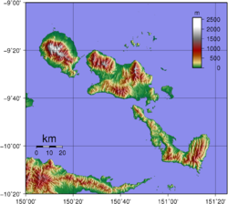
The D'Entrecasteaux Islands are volcanic with a number of areas of volcanism and active geothermal fields. Fergusson island has three volcanic masses over 1,828 m high. There are geothermal areas in the south east area of Goodenough Island and the Bwabwadana and Iamalele on Fergusson Island. A particularly active hot springs is located at Deidei on Fergusson. Between Fergusson and Normanby Islands the Dawson Straights Group has several volcanic centres that may define a partly submerged caldera
Caldera
A caldera is a cauldron-like volcanic feature usually formed by the collapse of land following a volcanic eruption, such as the one at Yellowstone National Park in the US. They are sometimes confused with volcanic craters...
; one of the cones on southwestern Fergusson Island may have erupted in 1350. Geologically the islands are blocks of the Australian plate
Plate tectonics
Plate tectonics is a scientific theory that describes the large scale motions of Earth's lithosphere...
that were once thrust deep in to the Earth's crust by plate collision. Since then, the blocks have risen to emerge as tall domed structures draped in pieces of the sea floor.
History
The group was named for the French navigator Antoine Raymond Joseph de Bruni d'EntrecasteauxBruni d'Entrecasteaux
Antoine Raymond Joseph de Bruni d'Entrecasteaux was a French navigator who explored the Australian coast in 1792 while seeking traces of the lost expedition of La Pérouse....
who, in his ship the Espérance, passed through the area in 1792 while searching for his missing compatriot, Jean-François de Galaup, comte de La Pérouse
Jean-François de Galaup, comte de La Pérouse
Jean François de Galaup, comte de Lapérouse was a French Navy officer and explorer whose expedition vanished in Oceania.-Early career:...
. Almost a century latter in 1874 Captain John Moresby
John Moresby
Captain John Moresby was a British Naval Officer who explored the coast of New Guinea and discovered the site of Port Moresby.Moresby was born in Allerford, Somerset, England, the son of Admiral Sir Fairfax Moresby...
of HMS Basilisk made a running survey
Running survey
A running survey is a rough survey made by a vessel while coasting. Bearings to landmarks are taken at intervals as the vessel sails offshore, and are used to fix features on the coast and further inland...
of the west coast of the islands and became the first European to make landfall.
In 1891 the Methodist Church of Australia established a mission station on Dobu Island. There natives were recruited to work in gold mines and on copra plantations. Another mission was established in 1898 at Bwaidoga, Mud Bay, on the south coast of Goodenough Island.
The island group became a focus of activity in World War II
World War II
World War II, or the Second World War , was a global conflict lasting from 1939 to 1945, involving most of the world's nations—including all of the great powers—eventually forming two opposing military alliances: the Allies and the Axis...
when Imperial Japanese troops were marooned on Goodenough Island briefly in 1942, before being attacked by the Australian 2/12th Battalion. In 1943 RAAF
Royal Australian Air Force
The Royal Australian Air Force is the air force branch of the Australian Defence Force. The RAAF was formed in March 1921. It continues the traditions of the Australian Flying Corps , which was formed on 22 October 1912. The RAAF has taken part in many of the 20th century's major conflicts...
mobile works squadrons constructed an airfield with a 6000 ft (1,829 m) airstrip and other facilities at Vivigani Airfield
Vivigani Airfield
Vivigani Airfield was an airstrip at Vivigani on Goodenough Island, part of the D'Entrecasteaux Islands in Papua New Guinea.-World War II:The Australian 2/12th Battalion reached Vivigani on 27 October 1942, occupying the island after defeating the Imperial Japanese troops marooned on the island...
on the site of a smaller, pre-war airstrip that existed at that location. It was used by allied forces from June 1943 to August 1944 as a staging point for operations in New Guinea and nearby occupied islands. Vivigani airstrip has been open to commercial service since 1963. A US Navy PT-Boat base was established on Fergusson Island in June, 1942. Normanby Island may have been a secret British military base during the war.