

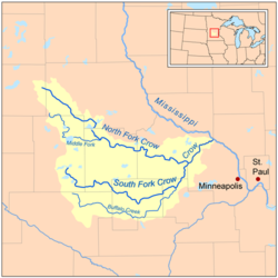
Crow River (Minnesota)
Encyclopedia
Tributary
A tributary or affluent is a stream or river that flows into a main stem river or a lake. A tributary does not flow directly into a sea or ocean...
of the Mississippi River
Mississippi River
The Mississippi River is the largest river system in North America. Flowing entirely in the United States, this river rises in western Minnesota and meanders slowly southwards for to the Mississippi River Delta at the Gulf of Mexico. With its many tributaries, the Mississippi's watershed drains...
in south-central Minnesota
Minnesota
Minnesota is a U.S. state located in the Midwestern United States. The twelfth largest state of the U.S., it is the twenty-first most populous, with 5.3 million residents. Minnesota was carved out of the eastern half of the Minnesota Territory and admitted to the Union as the thirty-second state...
in the United States
United States
The United States of America is a federal constitutional republic comprising fifty states and a federal district...
. It drains a watershed
Drainage basin
A drainage basin is an extent or an area of land where surface water from rain and melting snow or ice converges to a single point, usually the exit of the basin, where the waters join another waterbody, such as a river, lake, reservoir, estuary, wetland, sea, or ocean...
of 2,756 square miles (7,138 km²).
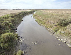
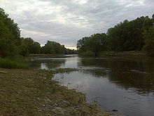
Hydrography
The Crow River flows for most of its length as three streams:- The North Fork Crow River, about 120 miles (195 km) long, flows from Grove Lake in eastern Pope CountyPope County, MinnesotaAs of the census of 2000, there were 11,236 people, 4,513 households, and 3,064 families residing in the county. The population density was 17 people per square mile . There were 5,827 housing units at an average density of 9 per square mile...
and follows a generally east-southeastward course through southwestern StearnsStearns County, MinnesotaAs of the census of 2000, there were 133,166 people, 47,604 households, and 32,132 families residing in the county. The population density was 99 people per square mile . There were 50,291 housing units at an average density of 37 per square mile...
, northeastern KandiyohiKandiyohi County, MinnesotaKandiyohi County is a county located in the U.S. state of Minnesota. As of 2010, its population was 42,239. Its county seat is Willmar.- History :...
, northern MeekerMeeker County, MinnesotaAs of the census of 2000, there were 22,644 people, 8,590 households, and 6,133 families residing in the county. The population density was 37 people per square mile . There were 9,821 housing units at an average density of 16 per square mile...
and central WrightWright County, MinnesotaWright County is a county located in the U.S. state of Minnesota, founded in 1855. As of 2010, the population was 124,700. Its county seat is Buffalo.-History:...
Counties, through Rice Lake and Lake Koronis and past the towns of RegalRegal, MinnesotaRegal is a city in Kandiyohi County, Minnesota, United States, along the North Fork of the Crow River. The population was 34 at the 2010 census.-Geography:According to the United States Census Bureau, the city has a total land area of ....
, PaynesvillePaynesville, MinnesotaAs of the census of 2000, there were 2,267 people, 934 households, and 594 families residing in the city. The population density was 1,715.2 people per square mile . There were 984 housing units at an average density of 744.5 per square mile...
and KingstonKingston, MinnesotaKingston is a city in Meeker County, Minnesota, along the North Fork of the Crow River. The population was 161 at the 2010 census.-Geography:According to the United States Census Bureau, the city has a total area of , all of it land....
. A minor headwaters tributary of the North Fork is named Skunk River. - The Middle Fork Crow River, about 50 miles (80 km) long, rises near BelgradeBelgrade, MinnesotaBelgrade is a town in Stearns County, Minnesota, United States. The population was 740 at the 2010 census. It is part of the St. Cloud Metropolitan Statistical Area.-Geography:...
in southwestern Stearns County and flows into Kandiyohi County, initially southward through Mud Lake and Nest Lake and past the town of New LondonNew London, MinnesotaAs of the census of 2000, there were 1,066 people, 415 households, and 261 families residing in the city. The population density was 1,103.4 people per square mile . There were 439 housing units at an average density of 454.4 per square mile...
, then eastward through Green Lake and Calhoun Lake and into northern Meeker County, where it joins the North Fork. - The South Fork Crow River, about 100 miles (160 km) long, flows from Wagonga and Little Kandiyohi Lakes in south-central Kandiyohi County and follows a generally eastward course through southwestern Meeker, northern McLeodMcLeod County, MinnesotaAs of the census of 2000, there were 34,898 people, 13,449 households, and 9,427 families residing in the county. The population density was 71 people per square mile . There were 14,087 housing units at an average density of 29 per square mile...
, northwestern CarverCarver County, MinnesotaAs of the census of 2000, there were 70,205 people, 24,356 households, and 18,778 families residing in the county. The population density was 197 people per square mile . There were 24,883 housing units at an average density of 70 per square mile...
and southeastern Wright Counties, past the towns of CosmosCosmos, MinnesotaCosmos is a city in Meeker County, Minnesota, United States, along the South Fork of the Crow River. The population was 473 at the 2010 census.Minnesota State Highways 4 and 7 are two of the main arterial routes in the community....
, HutchinsonHutchinson, MinnesotaAccording to the 2000 United States Census , there were 13,080 people, 5,333 households, and 3,418 families residing in the city. The population density was 1,763.6 people per square mile . There were 5,667 housing units at an average density of 764.1 per square mile...
, Lester PrairieLester Prairie, MinnesotaAs of the census of 2000, there were 1,377 people, 516 households, and 379 families residing in the city. The population density was 1,910.4 people per square mile . There were 531 housing units at an average density of 736.7 per square mile...
, MayerMayer, MinnesotaMayer is a city in Carver County, Minnesota, along the South Fork of the Crow River. The population was 1,749 at the 2010 census.-Geography:...
, WatertownWatertown, MinnesotaAs of the census of 2000, there were 3,029 people, 1,078 households, and 775 families residing in the city. The population density was 1,808.0 people per square mile . There were 1,100 housing units at an average density of 656.6 per square mile...
and DelanoDelano, MinnesotaDelano is a city in Wright County, Minnesota, United States. The population was 5,464 at the 2010 census. It is part of the Twin Cities Metropolitan Statistical Area.-Geography:...
. Portions of the South Fork's upper course have been heavily straightened and channelized.
Rockford, Minnesota
As of the census of 2000, there were 3,484 people, 1,296 households, and 929 families residing in the city. The population density was 2,021.2 people per square mile . There were 1,333 housing units at an average density of 773.3 per square mile...
to form the Crow River, which flows for about 30 miles (50 km) northeastward. The river's course is used to define the boundary between Wright
Wright County, Minnesota
Wright County is a county located in the U.S. state of Minnesota, founded in 1855. As of 2010, the population was 124,700. Its county seat is Buffalo.-History:...
and Hennepin
Hennepin County, Minnesota
Hennepin County is a county located in the U.S. state of Minnesota, named in honor of the 17th-century explorer Father Louis Hennepin. As of 2010 the population was 1,152,425. Its county seat is Minneapolis. It is by far the most populous county in Minnesota; more than one in five Minnesotans live...
Counties.
The Crow flows past Greenfield
Greenfield, Minnesota
Greenfield is a city in Hennepin County, Minnesota, United States, along the Crow River. The population was 2,777 at the 2010 census.-Geography:...
, Hanover
Hanover, Minnesota
Hanover is a city in Hennepin and Wright counties in the U.S. state of Minnesota. The population was 2,938 at the 2010 census. Most of Hanover lies in Wright County; only a small part of the city extends into Hennepin County....
, St. Michael
St. Michael, Minnesota
As of the census of 2000, there were 9,099 people, 2,926 households, and 2,437 families residing in the city. The population density was 279.4 people per square mile . There were 3,058 housing units at an average density of 93.9 per square mile...
, Otsego
Otsego, Minnesota
As of the census of 2000, there were 6,389 people, 2,062 households, and 1,674 families residing in the city. The population density was 217.5 people per square mile . There were 2,120 housing units at an average density of 72.2 per square mile...
and Dayton
Dayton, Minnesota
Dayton is a city in Hennepin and Wright counties in the U.S. state of Minnesota. The population was 4,671 at the 2010 census. Dayton is mainly in Hennepin County, but a part of the city extends into Wright County as well. It is the northernmost city in Hennepin County.The city of Dayton, platted...
; it enters the Mississippi River from the south at the common boundary between Otsego and Dayton.