
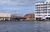
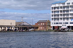
Crisfield, Maryland
Encyclopedia
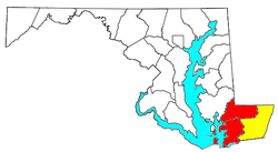
Somerset County, Maryland
-2010:Whereas according to the 2010 U.S. Census Bureau:*53.5% White*42.3% Black*0.3% Native American*0.7% Asian*0.0% Native Hawaiian or Pacific Islander*1.7% Two or more races*1.5% Other races*3.3% Hispanic or Latino -2000:...
, Maryland
Maryland
Maryland is a U.S. state located in the Mid Atlantic region of the United States, bordering Virginia, West Virginia, and the District of Columbia to its south and west; Pennsylvania to its north; and Delaware to its east...
, United States, located on the Tangier Sound
Tangier Sound
Tangier Sound is a sound of the Chesapeake Bay bounded on the west by Tangier Island in Virginia, and Smith Island and South Marsh Island in Maryland, by Deal Island in Maryland on the north, and the mainland of the Eastern Shore of Maryland and Pocomoke Sound on the east...
, an arm of the Chesapeake Bay
Chesapeake Bay
The Chesapeake Bay is the largest estuary in the United States. It lies off the Atlantic Ocean, surrounded by Maryland and Virginia. The Chesapeake Bay's drainage basin covers in the District of Columbia and parts of six states: New York, Pennsylvania, Delaware, Maryland, Virginia, and West...
. The population was 2,723 at the 2000 census. It is included in the Salisbury, Maryland
Salisbury, Maryland
-Demographics:Salisbury is the principal city of the Salisbury-Ocean Pines CSA, a Combined Statistical Area that includes the Salisbury metropolitan area and the Ocean Pines micropolitan area , which had a combined population of 176,657 at the 2010 census.As of the census of 2000, there were...
Metropolitan Statistical Area
Salisbury metropolitan area
The Salisbury Metropolitan Statistical Area, as defined by the United States Census Bureau, is an area consisting of two counties—Somerset and Wicomico—on Maryland's Eastern Shore, anchored by the city of Salisbury...
. Crisfield has the distinction of being the southernmost incorporated city in Maryland.
The city now known as Crisfield began as Annemessex Neck, a small fishing village. Its name was changed to Somers Cove, after Benjamin Summers, during European colonization. Only after the business potential for seafood was discovered did the quiet fishing town grow into a large city, due to the efforts of John W. Crisfield
John W. Crisfield
John Woodland Crisfield was a U.S. Congressman from Maryland, representing the sixth district from 1847—1849 and the first district from 1861—1863. The city of Crisfield, Maryland, is named after him. Politically he was a strong supporter of Union during American Civil War, opposing...
in bringing the Pennsylvania Railroad
Pennsylvania Railroad
The Pennsylvania Railroad was an American Class I railroad, founded in 1846. Commonly referred to as the "Pennsy", the PRR was headquartered in Philadelphia, Pennsylvania....
to the town. Crisfield briefly became the second most populous city in the entire state of Maryland, known as the "Seafood Capital of the World"; indeed, its success was so great that the train soot and oyster shells prompted the extension of the city's land into the marshes, so that the downtown area is literally built atop oyster shells, a common claim by those from the city.
Crisfield began to slip into decline as the declining health of the Chesapeake Bay began to reduce the watermen's catches. A "strategic revitalization plan" is underway to address the city's future growing needs, however. Currently, Crisfield is largely a destination for tourism. It hosts many annual events and festivals, the most prominent of which is the National Hard Crab Derby.
History
The Annemessex, a branch of the local PocomokePocomoke Indian Tribe
The Pocomoke were an Algonquian tribe who lived on what is now known as the Eastern Shore of Maryland. The Pocomoke and the Wicocomico were considered brother tribes.-External links:*...
Indian tribe of the Algonquin Nation, were the first inhabitants of the area now known as Crisfield. At the time, it was a small village known as Annemessex Neck, which the Pocomoke used for fishing. The Annemessex River nearby is the namesake of this branch of the Pocomokes. On February 10, 1663, Benjamin Summers, a settler from Yorkshire
Yorkshire
Yorkshire is a historic county of northern England and the largest in the United Kingdom. Because of its great size in comparison to other English counties, functions have been increasingly undertaken over time by its subdivisions, which have also been subject to periodic reform...
or Hertfordshire
Hertfordshire
Hertfordshire is a ceremonial and non-metropolitan county in the East region of England. The county town is Hertford.The county is one of the Home Counties and lies inland, bordered by Greater London , Buckinghamshire , Bedfordshire , Cambridgeshire and...
, England, arrived from Northampton County, Virginia
Northampton County, Virginia
As of the census of 2010, there were 12,389 people, 5,321 households, and 3,543 families residing in the county. The population density was 63 people per square mile . There were 6,547 housing units at an average density of 32 per square mile...
to claim his headright
Headright
A headright system is a legal grant of land to settlers who lived in Jamestown, Virginia. Headrights are most notable for their role in the expansion of the thirteen British colonies in North America; the Virginia Company of London gave headrights to settlers, and the Plymouth Company followed suit...
. He patented a 300 acres (1.21 km²) [though in actuality only 250 acres (1.01 km²)] parcel of land, which he named "Emmessex". He later patented another 200 acre (0.809372 km²) of land on September 23, 1683, naming it "Musketa Hummock". Both of these plots of land are located in the present-day Crisfield Election District. Another plot of land, named "Little Worth" and totalling 100 acre (0.404686 km²), was also patented in Annemessex. These three plots of land would eventually come to be known collectively as Somers Cove.
Somers Cove soon became a major distribution center for seafood along the East Coast. The town grew faster than many other settlements on the Delmarva Peninsula
Delmarva Peninsula
The Delmarva Peninsula is a large peninsula on the East Coast of the United States, occupied by most of Delaware and portions of Maryland and Virginia...
, with over 100 buildings in 1804 before Princess Anne
Princess Anne, Maryland
Princess Anne is a town in Somerset County, Maryland, United States. The population was 2,313 at the 2000 census. It is the county seat of Somerset County.Princess Anne is included in the Salisbury, Maryland Metropolitan Statistical Area....
and Salisbury
Salisbury, Maryland
-Demographics:Salisbury is the principal city of the Salisbury-Ocean Pines CSA, a Combined Statistical Area that includes the Salisbury metropolitan area and the Ocean Pines micropolitan area , which had a combined population of 176,657 at the 2010 census.As of the census of 2000, there were...
, with 40 and 4 respectively. It was only later discovered how lucrative the area was as a survey of the Chesapeake Bay in 1854 showed how much the waters around Somers Cove were colonized by oysters.
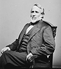
John W. Crisfield
John Woodland Crisfield was a U.S. Congressman from Maryland, representing the sixth district from 1847—1849 and the first district from 1861—1863. The city of Crisfield, Maryland, is named after him. Politically he was a strong supporter of Union during American Civil War, opposing...
, a Princess Anne
Princess Anne, Maryland
Princess Anne is a town in Somerset County, Maryland, United States. The population was 2,313 at the 2000 census. It is the county seat of Somerset County.Princess Anne is included in the Salisbury, Maryland Metropolitan Statistical Area....
attorney, was instrumental in bringing the Eastern Shore Railroad, a branch of the Pennsylvania Railroad
Pennsylvania Railroad
The Pennsylvania Railroad was an American Class I railroad, founded in 1846. Commonly referred to as the "Pennsy", the PRR was headquartered in Philadelphia, Pennsylvania....
system, to the Somers Cove seaport. The Crisfield Secondary Branch of the railroad opened on November 6 of that year. The town was later formally incorporated in 1872 as a city, which was renamed Crisfield in honor of the attorney's efforts. Due to the railroad, the economy of the new city was bolstered and Crisfield prospered greatly, as did other towns and settlements along its route, such as Marion Station
Marion Station, Maryland
Marion Station, also known as Marion, is an unincorporated community in Somerset County, Maryland, United States. It is located at the northern intersection of Maryland Route 413 and Maryland Route 667. After the arrival of the Pennsylvania Railroad arm known as the "Eastern Shore Railroad"...
to the north. Seafood was soon being shipped all over the United States, and Crisfield became known as the "Seafood Capital of the World", a nickname still carried by the city. An industrial boom followed, and by 1904, the City of Crisfield was the second largest city in Maryland, after Baltimore, with the population topping off at about 25,000 at the time, the attractiveness of the city's seafood industry having drawn in residents from as far away as New England
New England
New England is a region in the northeastern corner of the United States consisting of the six states of Maine, New Hampshire, Vermont, Massachusetts, Rhode Island, and Connecticut...
and the Midwestern United States
Midwestern United States
The Midwestern United States is one of the four U.S. geographic regions defined by the United States Census Bureau, providing an official definition of the American Midwest....
. The city also had a baseball team before long: the Crisfield Crabbers, who were the city's entry for the defunct Eastern Shore Baseball League
Eastern Shore Baseball League
The Eastern Shore Baseball League was a Class D minor league baseball league that operated on the Delmarva Peninsula for parts of three different decades. The league's first season was in 1922 and the last was in 1949, although the years were not consecutive, and featured teams from Maryland,...
.
The success of the city's seafood industry caused the city to end up with large amounts of train soot and oyster shells. Around the turn of the 20th century, businessmen would buy plots of land at the southwest edge of the city and discard the shells and soot into the salt marshes, creating a new, roughly half-mile long peninsula. Downtown Crisfield was built atop this new land, and this leads to the common statement that Crisfield was so prosperous that it is "literally built on top of oyster shells".
The city experienced several fires, the most well-known of which is known as the Great Fire of 1928. It began on March 29 at the Crisfield Opera House and quickly spread to the downtown area, completely destroying it and causing over $1 million in damages.
Crisfield's prosperity began to decline along with the health of the Chesapeake Bay. Oyster populations began to decline to the point where the watermen could no longer fully support themselves on their daily catches. Businesses began to move out of Crisfield, while others shut down. On April 1, 1976, the railroad that had brought prosperity to Crisfield was abandoned as Conrail
Consolidated Rail Corporation
The Consolidated Rail Corporation, commonly known as Conrail , was the primary Class I railroad in the Northeast U.S. between 1976 and 1999. The federal government created it to take over the potentially profitable lines of bankrupt carriers, including the Penn Central Transportation Company and...
was established; however, the railroad was succeeded by a new, straight vehicular highway
Maryland Route 413
Maryland Route 413 is a state highway in Somerset County in the U.S. state of Maryland. The route runs from a dead end at Crisfield's city dock, which is located on the Tangier Sound, northeast to U.S. Route 13 in Westover. It is the main highway leading into Crisfield, and is known as...
built before its abandoning and alongside its right-of-way. As large businesses in the United States grew, it passed the shrinking Crisfield by until only the late 20th century. Fast-food restaurants began to slowly find business in the city, starting in the late 1990s, alongside the many seafood restaurants already in town, and a large supermarket has been in city plans for a decade, though it only opened in April 2010. Crisfield has also been a target for large waterfront properties, with several large condominiums being built in the mid-2000s in the downtown area, along with other places flanking Crisfield's harbors. A "strategic revitalization plan" has been in the works since 2006, however, to address future growing needs and beautification of the city.
Crisfield continues to be famous for its seafood throughout Maryland and the United States, particularly the Maryland Crab, and it abounds with restaurants, seafood packing houses, and seafood distribution companies. Several seafood restaurants across the country carry the city's name.
Geography
Crisfield is a very compact city, utilizing almost all of its area for urban usage. According to the United States Census BureauUnited States Census Bureau
The United States Census Bureau is the government agency that is responsible for the United States Census. It also gathers other national demographic and economic data...
, the city has a total area of 3 mi2, of which, 1.6 mi2 of it is land and 1.4 mi2 of it (46.36%) is water. The city of Crisfield is surrounded by salt marshes and was built on a floodplain. As such, the city is especially prone to flooding during large storms and hurricanes, especially the downtown area.
Crisfield is the southern-most city in the state of Maryland; the point farthest south is geographically located at Ape Hole. Regardless of this, Southern Maryland
Southern Maryland
Southern Maryland in popular usage is composed of the state's southernmost counties on the "Western Shore" of the Chesapeake Bay. This region includes all of Calvert, Charles and St. Mary's counties and sometimes the southern portions of Anne Arundel and Prince George's counties.- History...
is an official region of the state not associated with the Eastern Shore
Eastern Shore of Maryland
The Eastern Shore of Maryland is a territorial part of the U.S. state of Maryland that lies predominately on the east side of the Chesapeake Bay and consists of nine counties. The origin of term Eastern Shore was derived to distinguish a territorial part of the State of Maryland from the Western...
, and areas of Saint Mary's County
Saint Mary's County, Maryland
Saint Mary's County is a county located in the U.S. state of Maryland.As of 2010, the population was 105,151. Its county seat is Leonardtown...
are often claimed to be the southernmost point of the state.
Climate
Crisfield's location on the Atlantic Coastal PlainAtlantic Coastal Plain
The Atlantic coastal plain has both low elevation and low relief, but it is also a relatively flat landform extending from the New York Bight southward to a Georgia/Florida section of the Eastern Continental Divide, which demarcates the plain from the ACF River Basin in the Gulf Coastal Plain to...
in Maryland
Maryland
Maryland is a U.S. state located in the Mid Atlantic region of the United States, bordering Virginia, West Virginia, and the District of Columbia to its south and west; Pennsylvania to its north; and Delaware to its east...
gives it a humid subtropical climate
Humid subtropical climate
A humid subtropical climate is a climate zone characterized by hot, humid summers and mild to cool winters...
, with hot, humid summers and cool to mild winters. Its proximity to water, as well as a common trend on the Delmarva Peninsula, means that the city does not see much snowfall in the winters.
Demographics
Combined Statistical Area
The United States Office of Management and Budget defines micropolitan and metropolitan statistical areas. Metropolitan and micropolitan statistical areas consist of one or more counties...
(CSA) which includes the Salisbury metropolitan area
Salisbury metropolitan area
The Salisbury Metropolitan Statistical Area, as defined by the United States Census Bureau, is an area consisting of two counties—Somerset and Wicomico—on Maryland's Eastern Shore, anchored by the city of Salisbury...
(Somerset
Somerset County, Maryland
-2010:Whereas according to the 2010 U.S. Census Bureau:*53.5% White*42.3% Black*0.3% Native American*0.7% Asian*0.0% Native Hawaiian or Pacific Islander*1.7% Two or more races*1.5% Other races*3.3% Hispanic or Latino -2000:...
and Wicomico
Wicomico County, Maryland
As of the census of 2010, there were 98,733 people, 37,220 households, and 24,172 families residing in the county. The population density was 261.7 people per square mile . There were 41,192 housing units at an average density of 109.2 per square mile...
counties) and the Ocean Pines micropolitan area
Worcester County, Maryland
-2010:Whereas according to the 2010 U.S. Census Bureau:*82.0% White*13.6% Black*0.3% Native American*1.1% Asian*0.0% Native Hawaiian or Pacific Islander*1.7% Two or more races*1.3% Other races*3.2% Hispanic or Latino -2000:...
(Worcester County
Worcester County, Maryland
-2010:Whereas according to the 2010 U.S. Census Bureau:*82.0% White*13.6% Black*0.3% Native American*1.1% Asian*0.0% Native Hawaiian or Pacific Islander*1.7% Two or more races*1.3% Other races*3.2% Hispanic or Latino -2000:...
), which had a combined population of 155,934 at the 2000 census
United States Census, 2000
The Twenty-second United States Census, known as Census 2000 and conducted by the Census Bureau, determined the resident population of the United States on April 1, 2000, to be 281,421,906, an increase of 13.2% over the 248,709,873 persons enumerated during the 1990 Census...
. Salisbury
Salisbury, Maryland
-Demographics:Salisbury is the principal city of the Salisbury-Ocean Pines CSA, a Combined Statistical Area that includes the Salisbury metropolitan area and the Ocean Pines micropolitan area , which had a combined population of 176,657 at the 2010 census.As of the census of 2000, there were...
is the principal city of this CSA.
As of the census
Census
A census is the procedure of systematically acquiring and recording information about the members of a given population. It is a regularly occurring and official count of a particular population. The term is used mostly in connection with national population and housing censuses; other common...
of 2000, there were 2,723 people, 1,172 households, and 723 families residing in the city. The population density
Population density
Population density is a measurement of population per unit area or unit volume. It is frequently applied to living organisms, and particularly to humans...
was 1,674.9 people per square mile (645.0/km²). There were 1,357 housing units at an average density of 834.7 per square mile (321.4/km²). The racial makeup of the city was 58.54% White, 37.46% African American, 0.40% Native American, 0.51% Asian, 0.04% Pacific Islander, 0.37% from other races
Race (United States Census)
Race and ethnicity in the United States Census, as defined by the Federal Office of Management and Budget and the United States Census Bureau, are self-identification data items in which residents choose the race or races with which they most closely identify, and indicate whether or not they are...
, and 2.68% from two or more races. Hispanic or Latino of any race were 1.65% of the population.
There were 1,172 households out of which 30.3% had children under the age of 18 living with them, 32.9% were married couples
Marriage
Marriage is a social union or legal contract between people that creates kinship. It is an institution in which interpersonal relationships, usually intimate and sexual, are acknowledged in a variety of ways, depending on the culture or subculture in which it is found...
living together, 25.4% had a female householder with no husband present, and 38.3% were non-families. 34.3% of all households were made up of individuals and 18.9% had someone living alone who was 65 years of age or older. The average household size was 2.30 and the average family size was 2.92.
In the city the population was spread out with 27.8% under the age of 18, 8.3% from 18 to 24, 24.5% from 25 to 44, 21.2% from 45 to 64, and 18.1% who were 65 years of age or older. The median age was 37 years. For every 100 females there were 75.6 males. For every 100 females age 18 and over, there were 71.3 males.
The median income for a household in the city was $17,979, and the median income for a family was $23,929. Males had a median income of $30,078 versus $20,670 for females. The per capita income
Per capita income
Per capita income or income per person is a measure of mean income within an economic aggregate, such as a country or city. It is calculated by taking a measure of all sources of income in the aggregate and dividing it by the total population...
for the city was $12,387. About 30.5% of families and 34.2% of the population were below the poverty line, including 46.8% of those under age 18 and 30.2% of those age 65 or over.
Crime
Crisfield gained a new police chief in 2007—Chief Michael L. Tabor, who retired from the BaltimoreBaltimore
Baltimore is the largest independent city in the United States and the largest city and cultural center of the US state of Maryland. The city is located in central Maryland along the tidal portion of the Patapsco River, an arm of the Chesapeake Bay. Baltimore is sometimes referred to as Baltimore...
Police Department
Baltimore Police Department
The Baltimore Police Department provides police services to the city of Baltimore, Maryland and was officially established by the Maryland Legislature on March 16, 1853...
to head law enforcement in the city. Since then, crime rates have been on a steady decline, generally halving between 2006 and 2008. The most prevalent crime in the city is property crime, down from a high of 180 in 2006 to 92 in 2008. Theft is also very common. Violent crimes, such as murder and forcible rape, are rare, though the numbers for those are on the decline as well. In January 2010, it was reported that Crisfield experienced an 81% decrease in crime rates of all kinds since 2007.
Economy
Crisfield's economy is centered largely around retail, health care, and automotive. Seafood is also an important part of Crisfield's economy, just as it has been for most of its existence, with several packing plants existing within the city. The largest employer inside Crisfield's limits is the McCready Memorial Hospital. The second largest employer in the city is the Sherwin-Williams plant (formerly Rubberset company), which manufactures paintbrushes and roller covers.In the past, the economy was centered on the watermen and seafood, and about 150 seafood processing and packing plants were located within the city in its heyday. As the health of the Chesapeake Bay began decline, so did the numbers of catches for the blue crab (numbers have fallen by 70% since the 1990s) and regulations have been placed on catching female crabs in order to control overharvesting.
Most of the labor force in Crisfield work outside of the city and elsewhere on the peninsula. The largest seafood employer in Somerset County is also located outside the city, but nearby in Hopewell. Additionally, a new industrial park is slated for construction as early as September 2010 just north of Crisfield, near Carvel Hall and along MD 413. This new park will expand Crisfield's corporate limits.
Culture
Due to Crisfield being the main access point to Smith Island, it is an area with many speakers of the unique Smith Island accent. It also serves the Smith Island cake, the Maryland state dessert, in many of its restaurants.Annual events
Since 1986, Crisfield has hosted the Scorchy Tawes Pro-Am Fishing Tournament. The 3-day tournament gives cash prizes for different fishing categories. A block-party is held each night of the tournament at Side Street Restaurant.The annual J. Millard Tawes
J. Millard Tawes
John Millard Tawes , a member of the United States Democratic Party, was the 54th Governor of Maryland in the United States from 1959 to 1967. He remains the only Marylander to be elected to the three positions of State Treasurer, Comptroller, and Governor.-Early life and family:Tawes was born to...
Crab
Crab
True crabs are decapod crustaceans of the infraorder Brachyura, which typically have a very short projecting "tail" , or where the reduced abdomen is entirely hidden under the thorax...
and Clam
Clam
The word "clam" can be applied to freshwater mussels, and other freshwater bivalves, as well as marine bivalves.In the United States, "clam" can be used in several different ways: one, as a general term covering all bivalve molluscs...
Bake takes place on the third Wednesday of each July. It began in 1976 and attracts many politicians from across the state each year.
Crisfield's largest event is the annual National Hard Crab Derby & Fair, which began in 1947 and occurs every Labor Day weekend. Major highlights of the Crab Derby include a parade through Main Street, the Little Miss, Little Mr. and Miss Crustacean Pageants, the Boat Docking Contest (which began in 1971), the Crab Picking contest, and the Crab Bowl. The Crab Bowl turns the Somers Cove Marina
Somers Cove Marina
-External links:*...
into fairgrounds with rides, concerts, vendor stands, and fireworks.
Museums
Crisfield has several museums: the J. Millard Tawes Historical Museum, the Ward Brothers Workshop, and the J. Millard Tawes Library.Government
Crisfield is said to have a mayor–council–manager government. Administration is handled by the City Manager, who is appointed by the mayor and city council. The mayor is elected by the citizens of Crisfield, and the council members are as well. All serve four-year terms.Sports and recreation
The city once had a minor league baseball team: the Crisfield Crabbers. They were the entry to the Eastern Shore Baseball LeagueEastern Shore Baseball League
The Eastern Shore Baseball League was a Class D minor league baseball league that operated on the Delmarva Peninsula for parts of three different decades. The league's first season was in 1922 and the last was in 1949, although the years were not consecutive, and featured teams from Maryland,...
; however, that league has been dismantled, so there is no longer a team.
Through Program Open Space, the city of Crisfield has recently received funding to build a new Crisfield Municipal Park, the first public park located in the city. The park will feature a gazebo, a picnic area, and a playground.
Crisfield is also located near and has access to Janes Island State Park
Janes Island State Park
Janes Island State Park is a state park in the state of Maryland. It is located in Somerset County, Maryland, on the Chesapeake Bay. The park features boat launch, canoe/kayak rental, cabins, camp fire programs, camp sites, camp store, dump station, fishing and crabbing, flat water canoeing and...
. Janes Island is a large marshy island made of almost completely undeveloped land, and is colonized by various birds and marine life. The park offers fishing, swimming, picnicking, camping, and has about thirty miles of water trails which can be accessed by canoe. The beaches allow swimming as well. There is also a playground near the entrance.
Public schools
Public schools in Crisfield are within the Somerset County Public SchoolsSomerset County Public Schools (Maryland)
Somerset County Public Schools is a public school system serving the residents of Somerset County, Maryland, United States.-History:The Somerset County schools became desegregated in 1969 after the federal government began to withheld education funds. The first African American School...
district, which is headquartered in Westover
Westover, Maryland
Westover is an unincorporated community in Somerset County, Maryland, United States. It is located on Maryland Route 413 near its terminus at U.S. Route 13. The small community is home to many important services in Somerset County....
. There are only two public schools in Crisfield:
- Carter G. Woodson Elementary School – This school is located on South Somerset Avenue and currently serves grades K–5. This was changed from 2004, where it was the middle school, serving grades 6–8; school consolidation in the county changed the school and gave it a renovation. Much earlier than that, the school was the Crisfield Colored High School.
- Crisfield Academy and High School – Originally known as just Crisfield High School, this building is located on North Somerset Avenue between the intersections of Potomac Street and Mercury Lane, and serves grades 8–12. Before consolidation, it handled grades 9–12. The school is the first educational facility built beyond the original Crisfield Academy, and has existed in four different buildings on three different sites, all located close to or on Somerset Avenue.
Private schools
- Crisfield Christian Academy – The building, located on Maryland AvenueMaryland Route 413Maryland Route 413 is a state highway in Somerset County in the U.S. state of Maryland. The route runs from a dead end at Crisfield's city dock, which is located on the Tangier Sound, northeast to U.S. Route 13 in Westover. It is the main highway leading into Crisfield, and is known as...
north of Maple Street, hosts the only private religious school in the city.
Other
- Crisfield Head Start – Crisfield's branch of the Head Start program was placed in the old Crisfield Elementary School #3 on Jacksonville RoadMaryland Route 358Maryland Route 358 is a state highway in the U.S. state of Maryland. Known as Jacksonville Road, the state highway runs from MD 413 in Crisfield north to the end of state maintenance near Alfred J. Lawson Road. MD 358 connects Crisfield with Janes Island State Park and Crisfield Municipal...
for over twenty years. In the mid-2000s the building was razed to make way for a Food Lion, and operations moved elsewhere. As of 2010, the facility occupies the H. Dewayne Whittington Primary School building on Asbury Avenue. Before school consolidation, this building was the public primary school, serving grades K–2.
Travel by water
As Crisfield's heritage is on the water, it has many points of access to the Tangier Sound and Chesapeake Bay. Crisfield has two public docks: the city dock, which is located at the end of Main Street (MD 413), which is where large commercial ships tend to dock. The city dock has a pavilion and is usually the site of many events that occur in Crisfield. The other is the county dock, located one block west at the end of Broad Street, which is largely a dock used for freight. This dock was recently rehabilitated in the mid-2000s. There is also the Little Boat Harbor, located on Brick Kiln Road, which is utilized mostly by smaller workboats.Crisfield also has a large marina
Marina
A marina is a dock or basin with moorings and supplies for yachts and small boats.A marina differs from a port in that a marina does not handle large passenger ships or cargo from freighters....
, called Somers Cove Marina
Somers Cove Marina
-External links:*...
, built in the 1960s and is currently owned by the State of Maryland. The marina is where boats to Smith Island
Smith Island, Maryland
Smith Island is a census-designated place in Somerset County, Maryland, United States. It is included in the Salisbury, Maryland Metropolitan Statistical Area....
and Tangier Island, Virginia can be boarded. Currently, there is also service from Crisfield to Reedville, Virginia
Reedville, Virginia
Reedville is an unincorporated town in Northumberland County in the Northern Neck region of the U.S. state of Virginia. It is located at the eastern terminus of U.S...
. The Somers Cove Marina is also notable as it is the main site of many of the large events in the city, such as the National Hard Crab Derby.
Throughout Crisfield's history, there has been discussion of a high-speed ferry link between Crisfield and a point on the Western Shore, with large vessels that can accommodate large numbers of vehicles and tractor-trailers. The Western Shore connection point has ranged from Point Lookout State Park in Maryland to Reedville
Reedville, Virginia
Reedville is an unincorporated town in Northumberland County in the Northern Neck region of the U.S. state of Virginia. It is located at the eastern terminus of U.S...
in Northumberland County
Northumberland County, Virginia
Northumberland County is a county located on the Northern Neck in the Commonwealth of Virginia, a state in the United States. In 2010, its population was 12,330. Its county seat is Heathsville...
, Virginia
Virginia
The Commonwealth of Virginia , is a U.S. state on the Atlantic Coast of the Southern United States. Virginia is nicknamed the "Old Dominion" and sometimes the "Mother of Presidents" after the eight U.S. presidents born there...
. Proponents of this high-speed ferry link cite that it will reduce travel times to adjacent points on the western shore by as much as two and a half hours as the Bay Bridges are far from one another, and that they will spur tourism and economic growth on both sides.
Major roads
The city of Crisfield is accessible by two main state highways: Maryland Route 413Maryland Route 413
Maryland Route 413 is a state highway in Somerset County in the U.S. state of Maryland. The route runs from a dead end at Crisfield's city dock, which is located on the Tangier Sound, northeast to U.S. Route 13 in Westover. It is the main highway leading into Crisfield, and is known as...
(the main route through the city and is known colloquially as "The Strip") and Maryland Route 667
Maryland Route 667
Maryland Route 667 is a state highway in Somerset County in the U.S. state of Maryland. The east–west route runs from the city of Crisfield, which is located on the Tangier Sound, to U.S. Route 13 west of Pocomoke, and passes through Hopewell, Marion, Hudson's Corner, and Rehobeth along...
. Both routes connect directly to U.S. Route 13
U.S. Route 13 in Maryland
U.S. Route 13 is a U.S. Highway running from Fayetteville, North Carolina north to Morrisville, Pennsylvania. In the U.S. state of Maryland, the route runs from the Virginia border south of Pocomoke City in Worcester County north to the Delaware border in Delmar, Wicomico County, where the route...
, the main north–south thoroughfare of the Delmarva Peninsula
Delmarva Peninsula
The Delmarva Peninsula is a large peninsula on the East Coast of the United States, occupied by most of Delaware and portions of Maryland and Virginia...
. Additionally, Maryland Route 358
Maryland Route 358
Maryland Route 358 is a state highway in the U.S. state of Maryland. Known as Jacksonville Road, the state highway runs from MD 413 in Crisfield north to the end of state maintenance near Alfred J. Lawson Road. MD 358 connects Crisfield with Janes Island State Park and Crisfield Municipal...
(Jacksonville Road) leads to the nearby Janes Island State Park
Janes Island State Park
Janes Island State Park is a state park in the state of Maryland. It is located in Somerset County, Maryland, on the Chesapeake Bay. The park features boat launch, canoe/kayak rental, cabins, camp fire programs, camp sites, camp store, dump station, fishing and crabbing, flat water canoeing and...
, and Maryland Route 460
Maryland Route 460
Maryland Route 460 is a state highway in the U.S. state of Maryland. Known as Hall Highway, the state highway runs from McCready Memorial Hospital east to MD 413 within Crisfield in southwestern Somerset County...
(Hall Highway) is the main access point to the hospital. Maryland Route 380
Maryland Route 380
Maryland Route 380 is a state highway in the U.S. state of Maryland. The state highway runs from Ape Hole Road in Lawsonia, Maryland north to Main Street at the city limit of Crisfield in southwestern Somerset County. MD 380, which is the southernmost state highway in Maryland, provides access...
(Byrdtown Road and Main Street Extension) lead to the Crisfield suburbs of Lawsonia and Byrdtown; this area is commonly referred to by the locals as "Down Neck".
Major streets not maintained by the state are Somerset Avenue, which is located at the northern edge of town and travels south, paralleling the eastern city boundary and fronted mostly by homes; all of the public schools in the city are located down this corridor. There is also Main Street, which provides access to City Hall, the post office, police department, the library, and many of the businesses in the city, and also intersects Somerset Avenue at the only stoplight in the city. Main Street merges with Maryland Route 413 near the Crisfield Fire Department, becoming a four-lane boulevard. Broadway Avenue, running parallel to Main Street one block south, was once a major business center in the city as well, fronted by many businesses and churches and passed directly through the city's marina; however, it no longer reaches the marina, and a large amount of the stores and warehouses along it are now closed.
Public transportation
Crisfield is also served by the commuter bus service of the lower Eastern Shore, Shore TransitShore Transit
Shore Transit is a commuter bus service on the Lower Eastern Shore of the state of Maryland in the United States, servicing Somerset, Wicomico, and Worcester counties. The company comes from the consolidation of Somerset Commuter, Worcester County Ride, and Wicomico Transit...
. Two routes serve the city of Crisfield: Route 1 (known locally simply as "the Crisfield bus"), and Route 3, which operates on Sunday only. Both routes travel along Somerset Avenue and MD 413, getting between the two by way of Cove Street, and also provide access to McCready Memorial Hospital. All buses provide access to Princess Anne
Princess Anne, Maryland
Princess Anne is a town in Somerset County, Maryland, United States. The population was 2,313 at the 2000 census. It is the county seat of Somerset County.Princess Anne is included in the Salisbury, Maryland Metropolitan Statistical Area....
, where there is a transfer hub, and riders can get access to Salisbury
Salisbury, Maryland
-Demographics:Salisbury is the principal city of the Salisbury-Ocean Pines CSA, a Combined Statistical Area that includes the Salisbury metropolitan area and the Ocean Pines micropolitan area , which had a combined population of 176,657 at the 2010 census.As of the census of 2000, there were...
and other points on the Eastern Shore.
Airports
Crisfield has a single airport, though its location is closer to Hopewell: the Crisfield Municipal AirportCrisfield Municipal Airport
Crisfield Municipal Airport is a public airport located from Crisfield in Somerset County, Maryland, United States. Crisfield is located near the center of the Delmarva Peninsula in the heart of Bay Country. The Atlantic Ocean is to the east and the Chesapeake Bay just a few miles to the west...
. The main access road to the airport is on Plantation Road in Hopewell, south of the MD 667 intersection there; from Crisfield it is accessible via Jacksonville Road
Maryland Route 358
Maryland Route 358 is a state highway in the U.S. state of Maryland. Known as Jacksonville Road, the state highway runs from MD 413 in Crisfield north to the end of state maintenance near Alfred J. Lawson Road. MD 358 connects Crisfield with Janes Island State Park and Crisfield Municipal...
. The airport has been a recent target for expansion.
Public utilities
Crisfield possesses three water towers and a public sewer system; both provide municipal services as far north as Plantation Road in Hopewell. The most recent water tower was installed in the early 2000s. It also possesses one single sewage water treatment plant, which is notably overburdened and obsolete.The main electrical provider in the city is Delmarva Power and Light, held by Pepco Holdings
Pepco Holdings
Pepco Holdings, Inc. is a holding company incorporated in February of 2001 for the purpose of effecting the acquisition of Conectiv Power Delivery by Potomac Electric Power Company . The acquisition was completed on August 1, 2002 at which time Pepco and Conectiv became wholly owned subsidiaries...
, and a large substation is located north of town. Choptank Electric Cooperative also serves the city's outskirts. In the past, Crisfield possessed a power plant, located downtown on Seventh Street. This was removed around the time of the decommissioning of the rail line, as the railroad once ended there; power is now tapped from a substation in Princess Anne
Princess Anne, Maryland
Princess Anne is a town in Somerset County, Maryland, United States. The population was 2,313 at the 2000 census. It is the county seat of Somerset County.Princess Anne is included in the Salisbury, Maryland Metropolitan Statistical Area....
via subtransmission line. The main telephone provider is Verizon Communications
Verizon Communications
Verizon Communications Inc. is a global broadband and telecommunications company and a component of the Dow Jones Industrial Average...
. In the mid-2000s, a fiber-optic cable
Optical fiber cable
An optical fiber cable is a cable containing one or more optical fibers. The optical fiber elements are typically individually coated with plastic layers and contained in a protective tube suitable for the environment where the cable will be deployed....
was installed along the length of MD 413, improving internet service. A prominent cellphone tower
Cell site
A cell site is a term used to describe a site where antennas and electronic communications equipment are placed, usually on a radio mast, tower or other high place, to create a cell in a cellular network...
was also installed in the center of Marion Station to the north in 2010.
Health care
Crisfield currently possesses the only hospital in Somerset County—McCready Memorial Hospital, which is accessible by Hall HighwayMaryland Route 460
Maryland Route 460 is a state highway in the U.S. state of Maryland. Known as Hall Highway, the state highway runs from McCready Memorial Hospital east to MD 413 within Crisfield in southwestern Somerset County...
and by Byrd Road from the north on Jacksonville Road
Maryland Route 358
Maryland Route 358 is a state highway in the U.S. state of Maryland. Known as Jacksonville Road, the state highway runs from MD 413 in Crisfield north to the end of state maintenance near Alfred J. Lawson Road. MD 358 connects Crisfield with Janes Island State Park and Crisfield Municipal...
. The nearest hospital outside of this one is in Salisbury
Salisbury, Maryland
-Demographics:Salisbury is the principal city of the Salisbury-Ocean Pines CSA, a Combined Statistical Area that includes the Salisbury metropolitan area and the Ocean Pines micropolitan area , which had a combined population of 176,657 at the 2010 census.As of the census of 2000, there were...
or in Berlin
Berlin, Maryland
Berlin is a town in Worcester County, Maryland, United States. The population was 3,491 at the 2000 census.-History:The town of Berlin had its start around the 1790s, part of the Burley Plantation, a land grant dating back to 1677...
. McCready Hospital is located on the Annemessex River, and is flanked by the Alice Byrd Tawes Nursing Home, which was built in 1968 and was replaced by a new four-story building in 2010.
Notable people
- Ward BrothersWard BrothersThe Ward brothers, Lemuel T. Ward and Steven W. Ward , were two brothers from Crisfield, Maryland, who became famous for their wooden wildfowl carvings, commonly called decoys. Their decoys are highly prized by collectors. Few examples of their work survive on the open market, as private...
, famous wooden-carved, wildfowl, decoy makers - J. Millard TawesJ. Millard TawesJohn Millard Tawes , a member of the United States Democratic Party, was the 54th Governor of Maryland in the United States from 1959 to 1967. He remains the only Marylander to be elected to the three positions of State Treasurer, Comptroller, and Governor.-Early life and family:Tawes was born to...
, 54th Governor of Maryland - Harry Clifton Byrd, American university administrator, educator, athlete, coach, and politician
In popular culture
Crisfield and its environs are the setting for most of the books in the Tillerman Cycle series by Cynthia VoigtCynthia Voigt
Cynthia Voigt is an American author of books for young adults dealing with various topics such as adventure, mystery, racism and child abuse. Her first book in the Tillerman family series, Homecoming, was nominated for several international prizes and made into a 1996 film...
.
The movie Hookman 2 was mostly filmed in Crisfield in winter 2010–2011 and is scheduled for release in fall 2011. Crisfield is the hometown of most of the cast and crew members and is called "Hometown, Maryland" in the movie.
See also
- EshelmanEshelmanEshelman was a marque of small American automobiles and other vehicles and implements including motor scooters, garden tractors, pleasure boats, aircraft, golf carts, snowplows, trailers, mail-delivery vehicles and more. The Cheston L...
- Janes Island LightJanes Island LightThe Janes Island Light was a screw-pile lighthouse located near Crisfield in the U.S. state of Maryland. Twice destroyed by ice, it was replaced in 1935 with an automated beacon.-History:...
- Marion Station, MarylandMarion Station, MarylandMarion Station, also known as Marion, is an unincorporated community in Somerset County, Maryland, United States. It is located at the northern intersection of Maryland Route 413 and Maryland Route 667. After the arrival of the Pennsylvania Railroad arm known as the "Eastern Shore Railroad"...
, a nearby community which also prospered due to the railroad and went into decline later - Tulls Corner, MarylandTulls Corner, MarylandTulls Corner is an unincorporated community in Somerset County, Maryland, United States.-History:Tulls Corner is located in Quindocqua just west of Quindocqua United Methodist Church, at the intersection of Tulls Corner Road and L. Q. Powell Road, near Marion Station, Maryland...
, a nearby ghost town - Crisfield ArmoryCrisfield ArmoryThe Crisfield Armory is a historic National Guard armory located at Crisfield, Somerset County, Maryland, United States. It is two stories tall with a full basement, emulates a Medieval fortification, and was built in 1927. Attached to the rear of this two-story main block is a narrower one-story...
- Crisfield Historic DistrictCrisfield Historic DistrictCrisfield Historic District is a national historic district at Crisfield, Somerset County, Maryland, United States. It consists of a cohesive collection of houses, churches, and commercial buildings dating primarily from about 1870 to 1930. They reflect the rapid growth of the town as the center...
- WBEY-FMWBEY-FMWBEY-FM is a radio station broadcasting a Country music format. Licensed to Crisfield, Maryland, USA. The station is currently owned by Bay Broadcasting, Inc. and features programing from ABC Radio .-External links:*...