

Craighead County, Arkansas
Encyclopedia
Craighead County is a county
located in the U.S. state
of Arkansas
. As of the 2010 census, the population was 96,443. It is included in the Jonesboro, Arkansas Metropolitan Statistical Area
. Craighead County is Arkansas's 58th county, formed on February 19, 1859, and named for state Senator Thomas Craighead
. The county has two county seat
s — Jonesboro
and Lake City
. It is one of several dry counties
within the state of Arkansas, in which the sale of alcoholic beverages is largely prohibited.
on April 9, 1682 by René Robert Cavelier, Sieur de La Salle who laid claim to all of the land drained by the Mississippi River
and its assorted tributaries. LaSalle's claim was named Louisiana
in honor of Louis XIV
, King of France
.
The Treaty of Fontainebleau (1762)
was signed between France and Spain
and ownership of the Louisiana
territory west of the Mississippi River
was transferred to the Spanish crown as a result of the Seven Years' War
and Craighead County became a Spanish possession.
Spain remained in control of the territory encompassing the county until October 1, 1800 when Napoleon Bonaparte forced Spain to return the lost territories to France under the Treaty of Ildefonso. Napoleon maintained grandiose plans to establish a vast French Empire in Louisiana
but the Royal Navy
prevented him from transferring troops or settlers to the acquired territories.
Fear was high in the United States
that Napoleon would attempt to close the Mississippi River
to American trade. President Thomas Jefferson
inquired about purchasing an area near the mouth of the river to ensure that it would stay open to American goods. Napoleon, having realized that his plans could not come to fruition, offered to sell the United States
the entire territory of Louisiana, including Craighead County, for $23,213,568.
The treaty was finalized in 1803 and the land that would become Craighead County became the possession of the United States
.
Craighead County remained in the Louisiana Territory
until the State of Louisiana was admitted to the Union. At that time the territory that includes modern day Arkansas was attached to the Missouri Territory
.
In 1813 the area was included in a new political subdivision known as Arkansas County which was a political subdivision of the Arkansas District of the Territory of Missouri. In 1815 the county was further subdivided and Lawrence County was formed with its seat at Davidsonville. This new county included most of what is now northern Arkansas. The modern Craighead county lay partially within Arkansas County and partially within Lawrence County.
Residents of the Missouri Territory soon began petitioning Congress for admission to the Union. Their request did not include the District of Arkansas and Arkansas residents petitioned for separate territorial status for their district. In 1819 the Arkansas Territory was formed.
In 1838, Poinsett County was formed and included most of present day Craighead County. This situation persisted until 1850 when residents of the area complained about the distance to the Poinsett County seat.
In 1858 State Senator William A. Jones
campaign platform included a promise to seek the formation of a new county for the area. His election was successful and helped push legislation for the formation of the new county.
The new county was to be formed from lands taken from Greene, Mississippi, and Poinsett counties, and it was to be named "Crowley County" in honor of Crowley's Ridge
which runs through the center of the county.
Senator Thomas Craighead
represented Mississippi County, and opposed the bill because the farmland it took from Mississippi County (commonly known as the Buffalo Island area) was a major source of property taxes for the county.
One day while Senator Craighead was away from the floor, Senator Jones amended the bill to change the county's name to "Craighead County". The Senate, thinking it was a compromise, approved the bill as amended; by the time Senator Craighead returned, the bill had already left the Senate, and he took no further action.
Craighead County was officially formed February 19, 1859; in gratitude, the citizens then named the main county seat Jonesboro, for Senator Jones. (Some sources say the name was actually proposed by Senator Craighead in a resolution.) Lake City, just across the St. Francis River from the Buffalo Island area, was added as a second county seat in 1883.
On January 1st 2011 Ed Hill was sworn in as Craighead County Judge.
On May 5th 2011 Craighead County Computer Services opened Craighead County first Data Center in the basement of the Craighead Courthouse Annex.
Information Technology Director- Erin Johnson
is the county's most prominent geological feature.
 As of the census
of 2000, there were 82,148 people, 32,301 households, and 22,093 families residing in the county. The population density
was 116 people per square mile (45/km²). There were 35,133 housing units at an average density of 49 per square mile (19/km²). The racial makeup of the county was 89.27% White
, 7.78% Black
or African American
, 0.33% Native American
, 0.60% Asian
, 0.02% Pacific Islander
, 0.93% from other races
, and 1.06% from two or more races. 2.12% of the population were Hispanic
or Latino
of any race.
There were 32,301 households out of which 32.30% had children under the age of 18 living with them, 53.30% were married couples
living together, 11.40% had a female householder with no husband present, and 31.60% were non-families. 25.20% of all households were made up of individuals and 9.10% had someone living alone who was 65 years of age or older. The average household size was 2.46 and the average family size was 2.96.
In the county the population was spread out with 24.10% under the age of 18, 14.00% from 18 to 24, 28.70% from 25 to 44, 21.40% from 45 to 64, and 11.80% who were 65 years of age or older. The median age was 33 years. For every 100 females there were 93.80 males. For every 100 females age 18 and over, there were 90.50 males.
The median income for a household in the county was $32,425, and the median income for a family was $40,688. Males had a median income of $30,366 versus $21,109 for females. The per capita income
for the county was $17,091. About 11.60% of families and 15.40% of the population were below the poverty line, including 19.40% of those under age 18 and 13.40% of those age 65 or over.
Universities:
County (United States)
In the United States, a county is a geographic subdivision of a state , usually assigned some governmental authority. The term "county" is used in 48 of the 50 states; Louisiana is divided into parishes and Alaska into boroughs. Parishes and boroughs are called "county-equivalents" by the U.S...
located in the U.S. state
U.S. state
A U.S. state is any one of the 50 federated states of the United States of America that share sovereignty with the federal government. Because of this shared sovereignty, an American is a citizen both of the federal entity and of his or her state of domicile. Four states use the official title of...
of Arkansas
Arkansas
Arkansas is a state located in the southern region of the United States. Its name is an Algonquian name of the Quapaw Indians. Arkansas shares borders with six states , and its eastern border is largely defined by the Mississippi River...
. As of the 2010 census, the population was 96,443. It is included in the Jonesboro, Arkansas Metropolitan Statistical Area
Jonesboro metropolitan area
The Jonesboro Metropolitan Statistical Area, as defined by the United States Census Bureau, is an area consisting of two counties – Craighead and Poinsett – in northeast Arkansas, anchored by the city of Jonesboro. As of the 2000 census, the MSA had a population of 107,762...
. Craighead County is Arkansas's 58th county, formed on February 19, 1859, and named for state Senator Thomas Craighead
Thomas Craighead
Thomas B. Craighead was an American politician and lawyer from the state of Arkansas. He served in the Arkansas State Senate representing Crittenden and Mississippi Counties.-Early life:...
. The county has two county seat
County seat
A county seat is an administrative center, or seat of government, for a county or civil parish. The term is primarily used in the United States....
s — Jonesboro
Jonesboro, Arkansas
Jonesboro is a city in and one of the two county seats of Craighead County, Arkansas, United States. According to the 2010 US Census, the population of the city was 67,263. A college town, Jonesboro is the largest city in northeastern Arkansas and the fifth most populous city in the state...
and Lake City
Lake City, Arkansas
Lake City is a town in Craighead County, Arkansas in the United States, along the St. Francis River. The population is 2,082 according to the 2010 census. It is included in the Jonesboro, Arkansas Metropolitan Statistical Area...
. It is one of several dry counties
Dry county
A dry county is a county in the United States whose government forbids the sale of alcoholic beverages. Some prohibit off-premises sale, some prohibit on-premises sale, and some prohibit both. Hundreds of dry counties exist across the United States, almost all of them in the South...
within the state of Arkansas, in which the sale of alcoholic beverages is largely prohibited.
History
Craighead County was part of the territory claimed by FranceFrance
The French Republic , The French Republic , The French Republic , (commonly known as France , is a unitary semi-presidential republic in Western Europe with several overseas territories and islands located on other continents and in the Indian, Pacific, and Atlantic oceans. Metropolitan France...
on April 9, 1682 by René Robert Cavelier, Sieur de La Salle who laid claim to all of the land drained by the Mississippi River
Mississippi River
The Mississippi River is the largest river system in North America. Flowing entirely in the United States, this river rises in western Minnesota and meanders slowly southwards for to the Mississippi River Delta at the Gulf of Mexico. With its many tributaries, the Mississippi's watershed drains...
and its assorted tributaries. LaSalle's claim was named Louisiana
Louisiana
Louisiana is a state located in the southern region of the United States of America. Its capital is Baton Rouge and largest city is New Orleans. Louisiana is the only state in the U.S. with political subdivisions termed parishes, which are local governments equivalent to counties...
in honor of Louis XIV
Louis XIV of France
Louis XIV , known as Louis the Great or the Sun King , was a Bourbon monarch who ruled as King of France and Navarre. His reign, from 1643 to his death in 1715, began at the age of four and lasted seventy-two years, three months, and eighteen days...
, King of France
France
The French Republic , The French Republic , The French Republic , (commonly known as France , is a unitary semi-presidential republic in Western Europe with several overseas territories and islands located on other continents and in the Indian, Pacific, and Atlantic oceans. Metropolitan France...
.
The Treaty of Fontainebleau (1762)
Treaty of Fontainebleau (1762)
The Treaty of Fontainebleau was a secret agreement in which France ceded Louisiana to Spain. The treaty followed the last battle in the French and Indian War, the Battle of Signal Hill in September 1762, which confirmed British control of Canada. However, the associated Seven Years War continued...
was signed between France and Spain
Spain
Spain , officially the Kingdom of Spain languages]] under the European Charter for Regional or Minority Languages. In each of these, Spain's official name is as follows:;;;;;;), is a country and member state of the European Union located in southwestern Europe on the Iberian Peninsula...
and ownership of the Louisiana
Louisiana
Louisiana is a state located in the southern region of the United States of America. Its capital is Baton Rouge and largest city is New Orleans. Louisiana is the only state in the U.S. with political subdivisions termed parishes, which are local governments equivalent to counties...
territory west of the Mississippi River
Mississippi River
The Mississippi River is the largest river system in North America. Flowing entirely in the United States, this river rises in western Minnesota and meanders slowly southwards for to the Mississippi River Delta at the Gulf of Mexico. With its many tributaries, the Mississippi's watershed drains...
was transferred to the Spanish crown as a result of the Seven Years' War
Seven Years' War
The Seven Years' War was a global military war between 1756 and 1763, involving most of the great powers of the time and affecting Europe, North America, Central America, the West African coast, India, and the Philippines...
and Craighead County became a Spanish possession.
Spain remained in control of the territory encompassing the county until October 1, 1800 when Napoleon Bonaparte forced Spain to return the lost territories to France under the Treaty of Ildefonso. Napoleon maintained grandiose plans to establish a vast French Empire in Louisiana
Louisiana
Louisiana is a state located in the southern region of the United States of America. Its capital is Baton Rouge and largest city is New Orleans. Louisiana is the only state in the U.S. with political subdivisions termed parishes, which are local governments equivalent to counties...
but the Royal Navy
Royal Navy
The Royal Navy is the naval warfare service branch of the British Armed Forces. Founded in the 16th century, it is the oldest service branch and is known as the Senior Service...
prevented him from transferring troops or settlers to the acquired territories.
Fear was high in the United States
United States
The United States of America is a federal constitutional republic comprising fifty states and a federal district...
that Napoleon would attempt to close the Mississippi River
Mississippi River
The Mississippi River is the largest river system in North America. Flowing entirely in the United States, this river rises in western Minnesota and meanders slowly southwards for to the Mississippi River Delta at the Gulf of Mexico. With its many tributaries, the Mississippi's watershed drains...
to American trade. President Thomas Jefferson
Thomas Jefferson
Thomas Jefferson was the principal author of the United States Declaration of Independence and the Statute of Virginia for Religious Freedom , the third President of the United States and founder of the University of Virginia...
inquired about purchasing an area near the mouth of the river to ensure that it would stay open to American goods. Napoleon, having realized that his plans could not come to fruition, offered to sell the United States
United States
The United States of America is a federal constitutional republic comprising fifty states and a federal district...
the entire territory of Louisiana, including Craighead County, for $23,213,568.
The treaty was finalized in 1803 and the land that would become Craighead County became the possession of the United States
United States
The United States of America is a federal constitutional republic comprising fifty states and a federal district...
.
Craighead County remained in the Louisiana Territory
Louisiana Territory
The Territory of Louisiana or Louisiana Territory was an organized incorporated territory of the United States that existed from July 4, 1805 until June 4, 1812, when it was renamed to Missouri Territory...
until the State of Louisiana was admitted to the Union. At that time the territory that includes modern day Arkansas was attached to the Missouri Territory
Missouri Territory
The Territory of Missouri was an organized incorporated territory of the United States that existed from June 4, 1812 until August 10, 1821, when the southeastern portion of the territory was admitted to the Union as the State of Missouri.-History:...
.
In 1813 the area was included in a new political subdivision known as Arkansas County which was a political subdivision of the Arkansas District of the Territory of Missouri. In 1815 the county was further subdivided and Lawrence County was formed with its seat at Davidsonville. This new county included most of what is now northern Arkansas. The modern Craighead county lay partially within Arkansas County and partially within Lawrence County.
Residents of the Missouri Territory soon began petitioning Congress for admission to the Union. Their request did not include the District of Arkansas and Arkansas residents petitioned for separate territorial status for their district. In 1819 the Arkansas Territory was formed.
In 1838, Poinsett County was formed and included most of present day Craighead County. This situation persisted until 1850 when residents of the area complained about the distance to the Poinsett County seat.
In 1858 State Senator William A. Jones
William Atkinson Jones
William Atkinson Jones was a member of the U.S. House of Representatives from 1891 to 1918.Jones was born in Warsaw, Virginia, and graduated from the law department of the University of Virginia in 1870...
campaign platform included a promise to seek the formation of a new county for the area. His election was successful and helped push legislation for the formation of the new county.
The new county was to be formed from lands taken from Greene, Mississippi, and Poinsett counties, and it was to be named "Crowley County" in honor of Crowley's Ridge
Crowley's Ridge
Crowley's Ridge is an unusual geological formation that rises 250 to above the alluvial plain of the Mississippi embayment in a line from southeastern Missouri to the Mississippi River near Helena, Arkansas. It is the most prominent feature in the Mississippi Alluvial Plain between Cape...
which runs through the center of the county.
Senator Thomas Craighead
Thomas Craighead
Thomas B. Craighead was an American politician and lawyer from the state of Arkansas. He served in the Arkansas State Senate representing Crittenden and Mississippi Counties.-Early life:...
represented Mississippi County, and opposed the bill because the farmland it took from Mississippi County (commonly known as the Buffalo Island area) was a major source of property taxes for the county.
One day while Senator Craighead was away from the floor, Senator Jones amended the bill to change the county's name to "Craighead County". The Senate, thinking it was a compromise, approved the bill as amended; by the time Senator Craighead returned, the bill had already left the Senate, and he took no further action.
Craighead County was officially formed February 19, 1859; in gratitude, the citizens then named the main county seat Jonesboro, for Senator Jones. (Some sources say the name was actually proposed by Senator Craighead in a resolution.) Lake City, just across the St. Francis River from the Buffalo Island area, was added as a second county seat in 1883.
On January 1st 2011 Ed Hill was sworn in as Craighead County Judge.
On May 5th 2011 Craighead County Computer Services opened Craighead County first Data Center in the basement of the Craighead Courthouse Annex.
Information Technology Director- Erin Johnson
Geography
According to the 2000 census, the county has a total area of 712.98 square miles (1,846.6 km²), of which 710.84 square miles (1,841.1 km²) (or 99.70%) is land and 2.14 square miles (5.5 km²) (or 0.30%) is water. Crowley's RidgeCrowley's Ridge
Crowley's Ridge is an unusual geological formation that rises 250 to above the alluvial plain of the Mississippi embayment in a line from southeastern Missouri to the Mississippi River near Helena, Arkansas. It is the most prominent feature in the Mississippi Alluvial Plain between Cape...
is the county's most prominent geological feature.
List Of Highways
- U.S. 63 Business
 Highway 1
 Highway 1 Business
 Highway 18
 Highway 18 Spur
 Highway 69
 Highway 91
 Highway 135
 Highway 139
 Highway 141
 Highway 148
 Highway 158
 Highway 226
 Highway 230
 Highway 349
 Highway 351
 Highway 463
Adjacent counties
- Greene County (north)
- Dunklin CountyDunklin County, MissouriDunklin County is a county located in the Bootheel of Southeast Missouri in the United States. As of the 2000 U.S. Census, the county's population was 33,155. A 2008 estimate, however, showed the population to be 31,454. The largest city and county seat is Kennett...
, MissouriMissouriMissouri is a US state located in the Midwestern United States, bordered by Iowa, Illinois, Kentucky, Tennessee, Arkansas, Oklahoma, Kansas and Nebraska. With a 2010 population of 5,988,927, Missouri is the 18th most populous state in the nation and the fifth most populous in the Midwest. It...
(northeast) - Mississippi County (east)
- Poinsett County (south)
- Jackson County (west)
- Lawrence County (northwest)
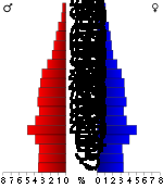
Demographics
Census
A census is the procedure of systematically acquiring and recording information about the members of a given population. It is a regularly occurring and official count of a particular population. The term is used mostly in connection with national population and housing censuses; other common...
of 2000, there were 82,148 people, 32,301 households, and 22,093 families residing in the county. The population density
Population density
Population density is a measurement of population per unit area or unit volume. It is frequently applied to living organisms, and particularly to humans...
was 116 people per square mile (45/km²). There were 35,133 housing units at an average density of 49 per square mile (19/km²). The racial makeup of the county was 89.27% White
Race (United States Census)
Race and ethnicity in the United States Census, as defined by the Federal Office of Management and Budget and the United States Census Bureau, are self-identification data items in which residents choose the race or races with which they most closely identify, and indicate whether or not they are...
, 7.78% Black
Race (United States Census)
Race and ethnicity in the United States Census, as defined by the Federal Office of Management and Budget and the United States Census Bureau, are self-identification data items in which residents choose the race or races with which they most closely identify, and indicate whether or not they are...
or African American
Race (United States Census)
Race and ethnicity in the United States Census, as defined by the Federal Office of Management and Budget and the United States Census Bureau, are self-identification data items in which residents choose the race or races with which they most closely identify, and indicate whether or not they are...
, 0.33% Native American
Race (United States Census)
Race and ethnicity in the United States Census, as defined by the Federal Office of Management and Budget and the United States Census Bureau, are self-identification data items in which residents choose the race or races with which they most closely identify, and indicate whether or not they are...
, 0.60% Asian
Race (United States Census)
Race and ethnicity in the United States Census, as defined by the Federal Office of Management and Budget and the United States Census Bureau, are self-identification data items in which residents choose the race or races with which they most closely identify, and indicate whether or not they are...
, 0.02% Pacific Islander
Race (United States Census)
Race and ethnicity in the United States Census, as defined by the Federal Office of Management and Budget and the United States Census Bureau, are self-identification data items in which residents choose the race or races with which they most closely identify, and indicate whether or not they are...
, 0.93% from other races
Race (United States Census)
Race and ethnicity in the United States Census, as defined by the Federal Office of Management and Budget and the United States Census Bureau, are self-identification data items in which residents choose the race or races with which they most closely identify, and indicate whether or not they are...
, and 1.06% from two or more races. 2.12% of the population were Hispanic
Race (United States Census)
Race and ethnicity in the United States Census, as defined by the Federal Office of Management and Budget and the United States Census Bureau, are self-identification data items in which residents choose the race or races with which they most closely identify, and indicate whether or not they are...
or Latino
Race (United States Census)
Race and ethnicity in the United States Census, as defined by the Federal Office of Management and Budget and the United States Census Bureau, are self-identification data items in which residents choose the race or races with which they most closely identify, and indicate whether or not they are...
of any race.
There were 32,301 households out of which 32.30% had children under the age of 18 living with them, 53.30% were married couples
Marriage
Marriage is a social union or legal contract between people that creates kinship. It is an institution in which interpersonal relationships, usually intimate and sexual, are acknowledged in a variety of ways, depending on the culture or subculture in which it is found...
living together, 11.40% had a female householder with no husband present, and 31.60% were non-families. 25.20% of all households were made up of individuals and 9.10% had someone living alone who was 65 years of age or older. The average household size was 2.46 and the average family size was 2.96.
In the county the population was spread out with 24.10% under the age of 18, 14.00% from 18 to 24, 28.70% from 25 to 44, 21.40% from 45 to 64, and 11.80% who were 65 years of age or older. The median age was 33 years. For every 100 females there were 93.80 males. For every 100 females age 18 and over, there were 90.50 males.
The median income for a household in the county was $32,425, and the median income for a family was $40,688. Males had a median income of $30,366 versus $21,109 for females. The per capita income
Per capita income
Per capita income or income per person is a measure of mean income within an economic aggregate, such as a country or city. It is calculated by taking a measure of all sources of income in the aggregate and dividing it by the total population...
for the county was $17,091. About 11.60% of families and 15.40% of the population were below the poverty line, including 19.40% of those under age 18 and 13.40% of those age 65 or over.
Cities and towns
|
Brookland, Arkansas Brookland is a town in Craighead County, Arkansas, United States. The population was 1,332 at the 2000 census. It is included in the Jonesboro, Arkansas Metropolitan Statistical Area.-Geography:Brookland is located at .... Caraway, Arkansas Caraway is a town in Craighead County, Arkansas, United States. The population was 1,349 at the 2000 census. It is included in the Jonesboro, Arkansas Metropolitan Statistical Area.-Geography:Caraway is located at .... Cash, Arkansas Cash is a town in Craighead County, Arkansas, United States. The population was 294 at the 2000 census. It is included in the Jonesboro, Arkansas Metropolitan Statistical Area.-Geography:Cash is located at .... |
Egypt, Arkansas Egypt is a town in Craighead County, Arkansas, United States. The population was 101 at the 2000 census. It is included in the Jonesboro, Arkansas Metropolitan Statistical Area.-Geography:Egypt is located at .... Herman, Arkansas Herman is an unincorporated community in Craighead County, Arkansas, United States. Its location is .-History of the Community Name:The locale of Herman began as a railroad stop with the post office being called Bellefield... Jonesboro, Arkansas Jonesboro is a city in and one of the two county seats of Craighead County, Arkansas, United States. According to the 2010 US Census, the population of the city was 67,263. A college town, Jonesboro is the largest city in northeastern Arkansas and the fifth most populous city in the state... Lake City, Arkansas Lake City is a town in Craighead County, Arkansas in the United States, along the St. Francis River. The population is 2,082 according to the 2010 census. It is included in the Jonesboro, Arkansas Metropolitan Statistical Area... |
Monette, Arkansas Monette is a city in Craighead County, Arkansas, United States. The population was 1,247 at the 2009 census. It is included in the Jonesboro, Arkansas Metropolitan Statistical Area.-Geography:Monette is located at .... |
Townships
- Big Creek (BonoBono, ArkansasBono is a city in Craighead County, Arkansas, United States. The population was 1,512 at the 2000 census. Population estimate as of 2008 was 1,599. It is included in the Jonesboro, Arkansas Metropolitan Statistical Area...
) - Black Oak (CarawayCaraway, ArkansasCaraway is a town in Craighead County, Arkansas, United States. The population was 1,349 at the 2000 census. It is included in the Jonesboro, Arkansas Metropolitan Statistical Area.-Geography:Caraway is located at ....
) - Brookland (BrooklandBrookland, ArkansasBrookland is a town in Craighead County, Arkansas, United States. The population was 1,332 at the 2000 census. It is included in the Jonesboro, Arkansas Metropolitan Statistical Area.-Geography:Brookland is located at ....
) - Buffalo (MonetteMonette, ArkansasMonette is a city in Craighead County, Arkansas, United States. The population was 1,247 at the 2009 census. It is included in the Jonesboro, Arkansas Metropolitan Statistical Area.-Geography:Monette is located at ....
) - Gilkerson (part of JonesboroJonesboro, ArkansasJonesboro is a city in and one of the two county seats of Craighead County, Arkansas, United States. According to the 2010 US Census, the population of the city was 67,263. A college town, Jonesboro is the largest city in northeastern Arkansas and the fifth most populous city in the state...
) - Greenfield (small part of JonesboroJonesboro, ArkansasJonesboro is a city in and one of the two county seats of Craighead County, Arkansas, United States. According to the 2010 US Census, the population of the city was 67,263. A college town, Jonesboro is the largest city in northeastern Arkansas and the fifth most populous city in the state...
) - Herndon
- Jonesboro (largest portion of JonesboroJonesboro, ArkansasJonesboro is a city in and one of the two county seats of Craighead County, Arkansas, United States. According to the 2010 US Census, the population of the city was 67,263. A college town, Jonesboro is the largest city in northeastern Arkansas and the fifth most populous city in the state...
) - Lake City
- Lester
- Little Texas (small part of CashCash, ArkansasCash is a town in Craighead County, Arkansas, United States. The population was 294 at the 2000 census. It is included in the Jonesboro, Arkansas Metropolitan Statistical Area.-Geography:Cash is located at ....
) - Maumelle (BayBay, ArkansasBay is a city in Craighead County, Arkansas, United States. The population was 1,800 at the 2000 census. It is included in the Jonesboro, Arkansas Metropolitan Statistical Area.-Geography:Bay is located at ....
, part of JonesboroJonesboro, ArkansasJonesboro is a city in and one of the two county seats of Craighead County, Arkansas, United States. According to the 2010 US Census, the population of the city was 67,263. A college town, Jonesboro is the largest city in northeastern Arkansas and the fifth most populous city in the state...
) - Nettleton (part of JonesboroJonesboro, ArkansasJonesboro is a city in and one of the two county seats of Craighead County, Arkansas, United States. According to the 2010 US Census, the population of the city was 67,263. A college town, Jonesboro is the largest city in northeastern Arkansas and the fifth most populous city in the state...
) - Powell
- Prairie
- Promised Land (EgyptEgypt, ArkansasEgypt is a town in Craighead County, Arkansas, United States. The population was 101 at the 2000 census. It is included in the Jonesboro, Arkansas Metropolitan Statistical Area.-Geography:Egypt is located at ....
) - Taylor
- Texas (most of CashCash, ArkansasCash is a town in Craighead County, Arkansas, United States. The population was 294 at the 2000 census. It is included in the Jonesboro, Arkansas Metropolitan Statistical Area.-Geography:Cash is located at ....
)
Education
School districts include:- Jonesboro Public SchoolsJonesboro Public SchoolsJonesboro Public Schools is a school district headquartered in Jonesboro, Arkansas.-Secondary schools:* High schools** Jonesboro High School* Junior high schools** Annie Camp Junior High School** Douglas MacArthur Junior High School...
- Nettleton Public Schools
- Valley View Public Schools
- Westside Consolidated School DistrictWestside Consolidated School DistrictWestside Consolidated School District #5 is a school district headquartered in unincorporated Craighead County, Arkansas, near Jonesboro.The district serves several rural communities in the county, including Bono, Cash, and Egypt...
Universities:
- Arkansas State University